Showing 267 items
matching historic property
-
 Federation University Historical Collection
Book - School of Mines Ballarat Minute Book, Ballarat School of Mines and Industries, Ballarat, Ballarat School of Mines Property and Equipment committee,Historical Educational Specification Committee, Legislation/constitution committee and appeal committee minutes 1983-88, 07/10/1976
School of mines Ballarat is a predecessor of Federation UniversityThese minute books record the meetings of several different committees, including Equipment committee, student loan fund committee, legislation and constitution committee, appeal committee, and historic committee of School of Mines in the 1970's and give us an understanding of the operations of the School of Mines in that era and of the people involved with the institution at that time. It shows projects that were being undertaken at the institution at the time and gives us an historical perspective on project costs and the type of work being doneLarge dark red book with cold writing on the front cover and labels stuck on the spine5 labels on the spineschool of mine ballarat, property and equipment committee, k.j flecknoe, r.c morgan, p.r. shiells, r.c lovett, s.a mendelson, e.j tippett, g.d macgregor, l.f.j hillman, t.a wiseman, i.c clarke, m.b john, w.t ryan, j. van dreven, historical committee, r. h hollioake, p.h dixon, j. vernon, arthur nicholson, g.h beanland, b.c muir, a.k webb, b. light, m.r armstrong, the wattle tea rooms -
 Phillip Island and District Historical Society Inc.
Photograph, Underdown home in Rhyll, About 1900
The Underdown family were early settlers on the Island, possibly in the 1890s. They lived in Reid Street, Rhyll. Name of donor was Ossie or Oswald Underdown.[Source Cherry McFee]Faded black & white photo on cardboard mount of a man, believed to be Mr Underdown, standing in front of a house with a dog and horse.Underdown property in Rhyll. Later Strawberry Gardens.underdown family, rhyll, buildings - historical, historic homes, local identities, oswald underdown, photographs -
 Phillip Island and District Historical Society Inc.
Photograph, 1960's
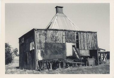
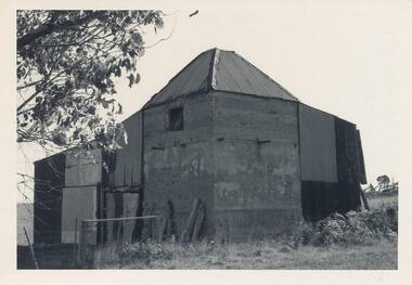
Donated by N. M. & J. D. Archibald. April, 1973.Chicory Kiln. Rhyll. Mr. U. Stoppa. Poured cement, Iron and Wood outside. built about 1940. Mr. Alex Neely & family on property. Chicory Kiln Album.local history, photography, photographs, agriculture buildings, historic, chicory kiln, rhyll, phillip island, u stoppa, a neely, n & j archibald -
 Phillip Island and District Historical Society Inc.
Photograph, 1960's
Donated by N. M. & J. D. Archibald. April, 1973.Black & White Photograph. Chicory Kiln. Rhyll - Mr. V. Stoppa. concrete. Built in 1940's on the old Duffus property. Built by Mr. Boyes. Chicory Kiln Album.local history, photography, photographs, agriculture buildings, historic, chicory kiln, rhyll, phillip island, u stoppa, mr boyes, n & j archibald -
 Phillip Island and District Historical Society Inc.
Photograph, 1978/9
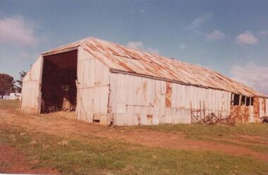
The big Hayshed was built by J. D. McHaffie on his property at Ventnor. He used timber washed up by the sea and roofing iron from the dome of the Exhibition Building in London. After purchasing the historic McHaffie homestead, Mr Harbison removed most of the buildings to Innishowen. It was still standing in 1977."Innishowen". Coloured photograph of large galvanised iron haystack, rusted with age. Part of timber frame visible at right hand side. Training Jinker shown against the side of shed.local history, photographs, buildings - historical, coloured photograph, john cook, innishowen, ventnor, phillip island -
 Phillip Island and District Historical Society Inc.
Photograph, 1978/79
Glen Isla built by Bob Anderson about 1870. The Anderson family lived there for many years. Purchased by Mr & Mrs Lunn in 1971. A single fronted weatherboard white painted with blue roof. A large two story building behind. Mr & Mrs Baker bought Glen Isla early 2000s and run as an Accommodation property.Glen Isla built by Bob Anderson about 1870.local history, photographs, buildings, historic, buildings - historical, coloured photograph, john cook, phillip island, glen isla homestead -
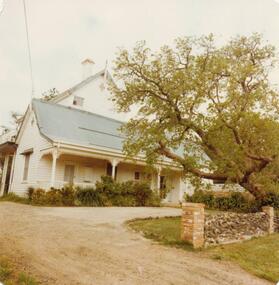 Phillip Island and District Historical Society Inc.
Photograph, 1978/79
Glen Isla built by Bob Anderson about 1870. The Anderson family lived there for many years. Mr & Mrs Lunn bought Glen Isla in 1971. A single fronted white weatherboard cottage, large 2 story building behind seemingly attached. Sprawling tree across right front of photograph behind a rock fence with brick pillars - a wide yellow gravel drive. Bought by Mr & Mrs Baker early 2000s and run as an accommodation property.Glen Isla built by Bob Anderson about 1870local history, photographs, buildings, historic, buildings - historical, coloured photograph, john cook, phillip island, glen isla homestead -
 Phillip Island and District Historical Society Inc.
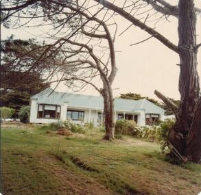
Photograph, 1978/79
"Tallawalla" once named "Everton". Built by Joseph Richardson about 1870 and lived in by several generations of the Richardsons for many years. Bought by Mr & Mrs Ed Rayner. Ranch style white painted home with blue roof. Set to back of property - garden - drive and two tall trees in the foreground. A large tree on left side of home."Talawalla" once named "Everton". Built by Joseph Richardson - 1870.local history, photographs, buildings, historic, buildings - historical, coloured photograph, john cook, phillip island, talawalla homestead -
 Phillip Island and District Historical Society Inc.
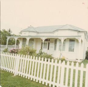
Photograph, 1978/79
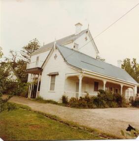
Originally The Warley Hospital built by Robert Walpole in 1908 and moved to its present site in Genista Street, when the present hospital building was erected c 1967. Now owned by Mr Reith. In 1923 Mr & Mrs W E Thompson purchased the property of the late Robert Walpole and presented it to the people of Phillip Island for a hospital.Early house built by Robert Walpole. White timber with pale blue roof. Lace work on verandah. Two bay windows. White picket fence.local history, photographs, buildings, historic, buildings - historical, coloured photograph, john cook, phillip island, warley hospital -
 Phillip Island and District Historical Society Inc.
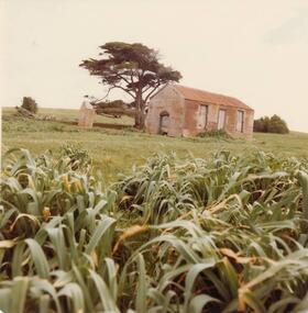
Photograph, 1978 - 79
One of a pair of settlers homes on the property of the Cameron Family, Watts Road, Ventnor. built about 1880.Photograph of two houses at Cameron property, Ventnor. One intact - the other in ruins. Built of corrugated iron.local history, photographs, buildings - historic, coloured photograph, john cook, phillip island, cameron's settlers homes -
 Greensborough Historical Society
Book, Heidelberg since 1836: a pictorial History. Text by Cyril Cummins, 1971_
A history of white settlement of the Heidelberg area. Contains historic photos and description of the growth of the area.Produced by the Heidelberg Historical Society with financial assistance from the City of Heidelberg.A history of Heidelberg compiled to mark the centenary of Heidelberg being granted 'shire' status in 1871. Covers the period 1836-1970. 5 copies. (copy 5 is not for loan and filed in FileCab:Heidelberg - this copy was the property of Frances Sheppard, Secretary to the Town Clerk and includes other memorabilia)Elsa Jones [and address] 1971heidelberg, heidelberg historial society -
 Greensborough Historical Society
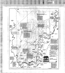
Map, Heidelberg: Historic River Landscape Assessment, Historical Maps. Map A To 1838. Country of the Wawarang, 1985c
Geographical area of around 35 sq. kilometres marked with physical features such as major roads, rivers, vegetation and properties, with contemporary notes on landowners, descriptions and comments on the land and its development. Bounded by Shire of Diamond Valley to the North, Darebin Creek to the West and Plenty River to the East.Black an white sketch map on white paperheidelberg, heidelberg - maps -
 Greensborough Historical Society
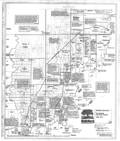
Map, Heidelberg: Historic River Landscape Assessment. Historical Maps. Map B 1838-1851, "The Distinctly aristocratic locality", 1985c
Geographical area of around 35 sq. kilometres marked with physical features such as major roads, rivers, vegetation and properties, with contemporary notes on landowners, descriptions and comments on the land and its development. Bounded by Shire of Diamond Valley to the North, Darebin Creek to the West and Plenty River to the EastBlack and white sketch map on white paperheidelberg, heidelberg - maps -
 Greensborough Historical Society
Map, Heidelberg. Historic River Landscape Assessment. Historical maps: Map C 1851-1863. "The Garden of the colony", 1985c
Geographical area of around 35 sq. kilometres marked with physical features such as major roads, vegetation and properties, with locations and notes of the increasing number of farms, gardens orchards and vineyards which had become established in addition to pastoral runs. Bounded by Shire of Diamond Valley to the North, Darebin Creek to the West and Plenty River to the East.Black and white sketch map on white paperheidelberg, heidelberg - maps -
 Greensborough Historical Society
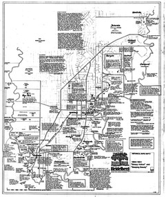
Map, Heidelberg: Historic River Landscape Assessment. Historical maps. Map D 1864 -1901 "Sleepy Hollow" and "Sleeping beauty", 1985c
Geographical area of c. 35 sq. kilometres marked with physical features such as major roads, rivers, vegetation and properties, with locations and notes on the increasing number of farms, orchards and vineyards that had been developed in addition to pastoral runs. Bounded by Shire of Diamond Valley to the North, Darebin Creek to the West, and Plenty River to the East.Black and white sketch on white paper. Second copy 600 x 430 cm printed in black on semi-opaque paperheidelberg, heidelberg - maps -
 Greensborough Historical Society
Map, Heidelberg: Historic River Landscape Assessment. Historical maps. Map E 1901-1934 "A Time of projects and improvements", 1985c
Geographical area of around 35 sq. kilometres marked with physical features such as major roads, railways (new extension to Eltham), rivers and properties, also housing sub-divisions and community facilities such as hospitals, parks and sporting reserves and indications of new small scale industries such as dairying. Bounded by Shire of Diamond Valley to the North, Darebin Creek to the West and Plenty River to the East. Black and white sketch map on white paperheidelberg, heidelberg - maps -
Glenelg Shire Council Cultural Collection
Document - Application Form - register of historic buildings, n.d
Application form to add a property to the register of historic buildings. Reverse has instructions on how to complete the form. White paper, black print - photocopy.historic buildings, register, application -
 Kiewa Valley Historical Society
Article - "This Week" - History of Green Tea, Green Tea - The Facts
'The Japanese company Ito En has been working solidly for the last five years to establish a green tea industry in this area .' The article includes assistance from the Alpine Shire, the cost and benefits of the schemeThis is of historic and social significance regarding industries in Mt Beauty and the Kiewa Valley especially as some no longer grow green tea as the affect of bush fires (smoke) made the industry not viable.Article with Title "Green Tea - The Facts" published on Page Seven from local publication "This Week" Falls Creek. Bogong. Mt. Beauty Summer Edition 21 Friday January 23rd 2004. Refers to properties of which there are 50% in the Kiewa Valley including Mt Beauty.green tea in mt beauty, japanese company ito en -
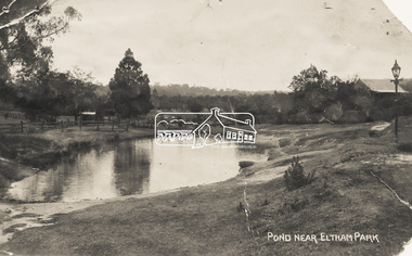 Eltham District Historical Society Inc
Photograph - Photo Postcard, Pond near Eltham Park, c.1910
This card depicts the pond near Eltham Park (later Eltham Lower Park) circa 1910. The view is taken from Maria Street (Main Road) opposite Dalton Street looking northwest across the Dalton Street road extension reserve (now Wingrove Park Trail) and Jarrold farm. A haystack is visible. Also visible is a gas streetlight and White Cloud cottage which belonged to the Jarrold family From the same collection as accession no. 00778, (Yarra at Eltham) - sent from Eltham and addressed to "Mr J. L. Brown, "Elthamville", Tinning Street, Brunswick" "with love from Nellie" who was most probably a member of the extended Brown family, and no. 00780 (Eltham, J.H. Clark Photo - dated 20 May 1911). Sending postcards to family and friends including short messages was a common form of communication in the early 20th century. Part of a slide show presentation "Bridges & Waterways of the Shire" by Russell Yeoman to the 13 September 1989 Society meeting. The presentation included slides of historic photos from the Shire of Eltham Pioneers collections as well as several recent views.Sending postcards to family and friends including short messages was a common form of communication in the early 20th century.Sepia postcard in very poor condition which has been removed from an album. Glue residue and album page adhering preventing information being readFront: Pond near Eltham Parkpostcard, eltham, pond, dalton street, duck pond, eltham park, elthamville, gas lamp, haystack, jarrold cottage, jarrold property, main road, maria street, white cloud cottage, wingrove park trail -
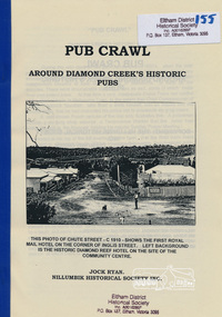 Eltham District Historical Society Inc
Book, Nillumbik Historical Society, Pub Crawl: around Diamond Creek's historic pubs by Jock Ryan, 2001
Hotels described include: Evelyn Arms Hotel or Tunnel Camp Hotel or Half-Way House, the Diamond Reef Hotel, the Loyal Diamond Lodge Hotel and the Royal Mail Hotel all located in Diamond Creek during a rapid population growth in Diamond Creek in the 1860s.This small publication discusses the history of local hotels in the Diamond Creek area during a significant period of development in the 1860s when mining took place in the local area. The history of hotels connects to the wider history and important social and civic link to the community at that time. [10] p. includes text and very poor photocopy reproductions of historical photographs. Perfect bound with plastic front cover only.EDHS Property stamp on front coverdiamond creek, hotels, pubs, bars, 1860s -
 Warrnambool and District Historical Society Inc.
Book, Book Certificate of Titles A-Z Index, C 1890
... . This book has many local names and properties and is an historic ...This book contains certificates of title and Crown grants which record local changes of ownership.many are in the township of Warrnambool while others relate to areas such as Nullawarre, Purnim and Framlingham.These documents come under the Transfer of lands act of 1890.This book has many local names and properties and is an historic link for the district.Brown heavy card cover with red fabric binding. It has an alphabetical index at the front followed by 200 pages of certificates of title.Descriptions of the land is written at the top of the pages with drawn and coloured diagrams below. The dates range from C 1878 to to C 1966. Some are certificate of title and others are Crown Grant. warrnambool, certificate of titles warrnambool 1900 -
 Eltham District Historical Society Inc
Negative - Photograph, Eltham War Memorial Obelisk 1914-1918, cnr. Main Road and Bridge Street, c.1925
Located on what was referred to as Obelisk Corner, improvements have been been made since the unveiling in August 1919 with the provision of a stone retaining wall topped with a chain link and granite stone boundary, most likely in conjunction with improvements to the intersection into Main Road. Along with the use of the name Obelisk Corner, the Bridge Street bridge was also known as Obelisk Bridge. The Eltham Obelisk was originally located at the corner of Bridge and Main Roads in 1919. In 1943 (WW2) the local community commenced plans to establish the Eltham War Memorial, a living memorial to benefit the children as opposed to a one in stone as per the obelisk. The Eltham War Memorial Trust was established in 1945. In 1947 the Trust intended for the Obelisk to be relocated from Bridge Street and Main Road to the Garden of Remembrance which was planned as part of the Baby Health Centre which was to be the first of three buildings of the Eltham War Memorial to be built in 1951. In 1951 the Eltham RSL was invited to be represented on the Eltham War Memorial Trust. Around this time, with pending roadworks, the obelisk was relocated to the front garden of the Eltham RSL sub branch on Main Road for safe keeping. In 2007, a suggestion was proposed by Harry Gilham (President, EDHS) to John Cohen (ERSL) to claim a special site along with the historic Shillinglaw trees on the now vacant former Eltham Shire Office site adjacent to the Eltham War Memorial precinct for relocation of the obelisk. In 2010 following the financial collapse and sale of the Eltham RSL Sub-Branch property and amalgamation with the Montmorency Eltham RSL sub-branch, the location of the obelisk was again in immediate jepoardy and in conjunction with Nillumbik Shire Council, the obelisk was relocated in front of the Eltham War Memorial buildings in preparation for the Dawn Service on Anzac Day 2012.This photo forms part of a collection of photographs gathered by the Shire of Eltham for their centenary project book,"Pioneers and Painters: 100 years of the Shire of Eltham" by Alan Marshall (1971). The collection of over 500 images is held in partnership between Eltham District Historical Society and Yarra Plenty Regional Library (Eltham Library) and is now formally known as the 'The Shire of Eltham Pioneers Photograph Collection.' It is significant in being the first community sourced collection representing the places and people of the Shire's first one hundred years.Digital image 4 x 5 inch B&W Negsepp, shire of eltham pioneers photograph collection, eltham, main road, eltham war memorial, bridge street, obelisk, obelisk corner -
 Eltham District Historical Society Inc
Photograph, Eltham War Memorial 1914-1918. Cnr. Main Road and Bridge Street, 3 August 1919
Dated 1919, the Eltham Obelisk is decorated with wreaths, most likely for what was originally known as Armistice Day though now known as Remembrance Day, 11 November. The location of the Obelisk at the corner of Bridge Street and Main Road became known as Obelisk Corner and the Bridge Street bridge was also referred to as Obelisk Bridge. The Eltham Obelisk was originally located at the corner of Bridge and Main Roads in 1919. In 1943 (WW2) the local community commenced plans to establish the Eltham War Memorial, a living memorial to benefit the children as opposed to a one in stone as per the obelisk. The Eltham War Memorial Trust was established in 1945. In 1947 the Trust intended for the Obelisk to be relocated from Bridge Street and Main Road to the Garden of Remembrance which was planned as part of the Baby Health Centre which was to be the first of three buildings of the Eltham War Memorial to be built in 1951. In 1951 the Eltham RSL was invited to be represented on the Eltham War Memorial Trust. Around this time, with pending roadworks, the obelisk was relocated to the front garden of the Eltham RSL sub branch on Main Road for safe keeping. In 2007, a suggestion was proposed by Harry Gilham (President, EDHS) to John Cohen (ERSL) to claim a special site along with the historic Shillinglaw trees on the now vacant former Eltham Shire Office site adjacent to the Eltham War Memorial precinct for relocation of the obelisk. In 2010 following the financial collapse and sale of the Eltham RSL Sub-Branch property and amalgamation with the Montmorency Eltham RSL sub-branch, the location of the obelisk was again in immediate jepoardy and in conjunction with Nillumbik Shire Council, the obelisk was relocated in front of the Eltham War Memorial buildings in preparation for the Dawn Service on Anzac Day 2012.This photo forms part of a collection of photographs gathered by the Shire of Eltham for their centenary project book,"Pioneers and Painters: 100 years of the Shire of Eltham" by Alan Marshall (1971). The collection of over 500 images is held in partnership between Eltham District Historical Society and Yarra Plenty Regional Library (Eltham Library) and is now formally known as 'The Shire of Eltham Pioneers Photograph Collection.' It is significant in being the first community sourced collection representing the places and people of the Shire's first one hundred years.Digital image 4 x 5 inch B&W Negsepp, shire of eltham pioneers photograph collection, eltham, main road, bridge street, eltham war memorial, obelisk, obelisk corner, wreath -
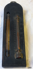 Flagstaff Hill Maritime Museum and Village
Thermometer, Early 20th Century
... with a historic person or property or with a known manufacturer or date ...A Storm Glass and Thermometer such as this one would be used in predicting or forecasting the weather. Farmers used predictions they read from their Storm Glass to prepare for stormy weather or for choosing a good time for planting or harvesting their crops. This could mean to them the difference between a good year and a year without income. This design has been in use since the early 1800’s. According to Admiral Fitzroy (who studied the storm glass and wrote instructions on its use) the liquid in the glass changes composition and appearance according to the direction of the air moving around it. He advised the user to disturb the contents once or twice a year by tipping it upside down and shaking it gently. Item is a good example of a barometer/thermometer that would have been in most homes and farms from the late 19th century and early 20th century. This item would have been massed produced at the time therefore easily available and quite cheap to purchase making this particular item not very significant as not associated with a historic person or property or with a known manufacturer or date.Storm Glass and Thermometer, commonly called a 'Cottage Barometer', mounted on a rectangular dark rectangle of wood, top corners rounded. The Storm Glass (or weather glass, or chemical weather glass) is suspended in a long oval shaped hole in the wood on left side, held in place at top and at bottom with 2 metal bands secured by nails. The glass of this gauge is hand blown, sealed at the top with another layer of glass. The watery fluid in the storm glass is opaque brownish colour with dark particles floating in it. (Storm glasses were usually filled with a variation of a mix of camphor, distilled water, ethyl alcohol and silver nitrate.) The alcohol thermometer is mounted on the right side of the wood, bulb resting in a hollow, attached at top and near base by 2 thin metal strips, with clover-leaf shaped ends, nailed into place. Over the bulb is nailed a metal guard with 3 ventilation slits cut into it. On left of thermometer is a scale, stamped into wood, 30 below zero to 130 above zero, in 2 degree intervals. A border of 2 thin parallel lines, with remnants of light coloured paint, is around the block of wood. On the reverse side, a metal plate is nailed to the top with a mounting hole in it. Impressed sideways along edge of barometer is "STORMY" "CHANGE" "FAIR". Across the top of the thermometer is a fleur de leis in the wood, and above this it is stamped "FAHRENHEIT". On right of the thermometer, stamped into the wood, is "BLOOD/HEAT", "SUMR/HEAT", "TEMPE/RATE", "FREEZ/ING". On the back of the wood, at the base, are remnants of a white sticker with "...111.73". Carved into the wood is "HOLLAND / AV". flagstaff hill, warrnambool, shipwrecked coast, flagstaff hill maritime museum, maritime museum, shipwreck coast, flagstaff hill maritime village, great ocean road, barometer, cottage barometer, storm glass, thermometer, chemical weather glass -
 Glen Eira Historical Society
Album - Album page, Lynedoch Avenue, Circa 1972
This photograph is part of the Caulfield Historical Album 1972. This album was created in approximately 1972 as part of a project by the Caulfield Historical Society to assist in identifying buildings worthy of preservation. The album is related to a Survey the Caulfield Historical Society developed in collaboration with the National Trust of Australia (Victoria) and Caulfield City Council to identify historic buildings within the City of Caulfield that warranted the protection of a National Trust Classification. Principal photographer thought to be Trevor Hart, member of Caulfield Historical Society. Most photographs were taken between 1966-1972 with a small number of photographs being older and from unknown sources. All photographs are black and white except where stated, with 386 photographs over 198 pages. National Trust - 9 Lynedoch Avenue, CAULFIELD NORTH VIC 3161 - Property No B3310 https://vhd.heritagecouncil.vic.gov.au/places/65663 - this record is just one photo with no text; the photo is almost identical to the photograph of the smaller gate on this album page. Page 124 of Photograph Album with two square photographs of gates.Handwritten: Lynedoch Avenue [top right] / 124 [bottom right]trevor hart, gates, cast iron gate, caulfield north, gate, hedge, cast iron spears, stone plinths, masonry column, masonry pillar, lynedoch avenue, st kilda east -
 Glen Eira Historical Society
Album - Album page, Munster Avenue, Circa 1972
This photograph is part of the Caulfield Historical Album 1972. This album was created in approximately 1972 as part of a project by the Caulfield Historical Society to assist in identifying buildings worthy of preservation. The album is related to a Survey the Caulfield Historical Society developed in collaboration with the National Trust of Australia (Victoria) and Caulfield City Council to identify historic buildings within the City of Caulfield that warranted the protection of a National Trust Classification. Principal photographer thought to be Trevor Hart, member of Caulfield Historical Society. Most photographs were taken between 1966-1972 with a small number of photographs being older and from unknown sources. All photographs are black and white except where stated, with 386 photographs over 198 pages. This house continues to occupy the property at 5 Munster Avenue Carnegie (Google map image capture Feb 2019).Page 136 of Photograph Album with one landscape photograph of an Edwardian house on Munster Avenue.Handwritten: Munster Street / Avenue [top right] / 136 [bottom right]trevor hart, garden, verandah, bull nosed verandah, edwardian, coloured glass, corrugated iron roof, bay window, gable, chimneys, porch, munster avenue, carnegie, box bay window, weatherboards, cast iron work, timber houses -
 Glen Eira Historical Society
Album - Album page, Neerim Road, Circa 1972
This photograph is part of the Caulfield Historical Album 1972. This album was created in approximately 1972 as part of a project by the Caulfield Historical Society to assist in identifying buildings worthy of preservation. The album is related to a Survey the Caulfield Historical Society developed in collaboration with the National Trust of Australia (Victoria) and Caulfield City Council to identify historic buildings within the City of Caulfield that warranted the protection of a National Trust Classification. Principal photographer thought to be Trevor Hart, member of Caulfield Historical Society. Most photographs were taken between 1966-1972 with a small number of photographs being older and from unknown sources. All photographs are black and white except where stated, with 386 photographs over 198 pages. Property is included the City of Glen Eira's Amendment C190glen as HO177 Ida Villa. As of 18/03/2021, Amendment C190 is noted as "Approval Under Consideration" by the Minister of Planning.Page 147 of Photograph Album with one landscape photograph of a Victorian brick house on Neerim Road.Handwritten: Neerim Road [top left] / 234 [under photo] / 147 [bottom left]trevor hart, neerim road, arched windows, verandah, porch, decorative brackets, bull nosed verandah, cast iron columns, ross land sales, ross, carnegie, victorian style, cast iron work, polychrome bricks, brick houses, tessellated tiled deck, ida villa -
 Glen Eira Historical Society
Album - Album page, St Joseph's Presbytery, Orrong Road, Circa 1972
This photograph is part of the Caulfield Historical Album 1972. This album was created in approximately 1972 as part of a project by the Caulfield Historical Society to assist in identifying buildings worthy of preservation. The album is related to a Survey the Caulfield Historical Society developed in collaboration with the National Trust of Australia (Victoria) and Caulfield City Council to identify historic buildings within the City of Caulfield that warranted the protection of a National Trust Classification. Principal photographer thought to be Trevor Hart, member of Caulfield Historical Society. Most photographs were taken between 1966-1972 with a small number of photographs being older and from unknown sources. All photographs are black and white except where stated, with 386 photographs over 198 pages. St Joseph's buildings and grounds are contributory properties to HO72 Elsternwick Estate and environs - City of Glen Eira.Page 162 - two photographs of St Joseph's Presbytery, Orrong Road.Handwritten: St Joseph's Presbytery Orrong Road [top right] / PREVIOUSLY "THE EMS" 1908 [under left photo] / 162 [bottom right]trevor hart, orrong road, curved windows, decorative brackets, arched windows, bay window, portico, slate roof, st joseph's presbytery, catholic church, st joseph's church, st joseph's primary school, porte cochere, the ems, elsternwick, rendered walls, clergy residences, drives, late victorian style, house names -
 Glen Eira Historical Society
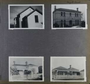
Album - Album page, Regent Street, Circa 1972
This photograph is part of the Caulfield Historical Album 1972. This album was created in approximately 1972 as part of a project by the Caulfield Historical Society to assist in identifying buildings worthy of preservation. The album is related to a Survey the Caulfield Historical Society developed in collaboration with the National Trust of Australia (Victoria) and Caulfield City Council to identify historic buildings within the City of Caulfield that warranted the protection of a National Trust Classification. Principal photographer thought to be Trevor Hart, member of Caulfield Historical Society. Most photographs were taken between 1966-1972 with a small number of photographs being older and from unknown sources. All photographs are black and white except where stated, with 386 photographs over 198 pages. At least 2 of these houses (17 and 84) are contributory properties to HO72 Elsternwick Estate and environs.Page 172 of Photograph Album with four photographs of differerent properties on Regent Street.Handwritten: Regent Street [top right] / 17 [under bottom left photo] / 84 [under bottom right photo] / 172 [bottom right]trevor hart, regent street, elsternwick, houses, mansions, cast iron work, verandahs -
 Glen Eira Historical Society
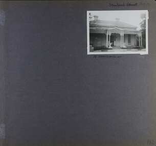
Album - Album page, Staniland Grove, Circa 1972
This album was created in approximately 1972 as part of a project by the Caulfield Historical Society to assist in identifying buildings worthy of preservation. The album is related to a Survey the Caulfield Historical Society developed in collaboration with the National Trust of Australia (Victoria) and Caulfield City Council to identify historic buildings within the City of Caulfield that warranted the protection of a National Trust Classification. Principal photographer thought to be Trevor Hart, member of Caulfield Historical Society. Most photographs were taken between 1966-1972 with a small number of photographs being older and from unknown sources. All photographs are black and white except where stated, with 386 photographs over 198 pages. 15 Staniland Grove is a contributory property to HO72 Elsternwick Estate and environs.Page 192 of Photograph Album with one photograph of a house on Staniland Grove.Handwritten: Staniland Street altered to Staniland Grove [top right] / 15 STANILAND ST [under photo] /192 [bottom right]trevor hart, chimneys, porch, villa residence, garden, verandah, 1890's, late victorian, decorative brackets, cast iron lacework, 1880's, slate roof, single storey, cast iron columns, cast iron frieze, elsternwick, boom period, triangulated pediment, coloured glass, mosaic tiling, complex tiled patterns, pots, italianate, staniland grove, rendered