Showing 80 items
matching plan of changing house
-
 City of Kingston
Pamphlet - Colour, W. H. Wood Estate Agent, Realising sub-divisional auction sale Bentleigh Park Estate, Bentleigh, 1920
Sales plan for land in the suburb of Bentleigh, bounded by Centre Road, and incorporating subdivisions on either side of Elizabeth Street (Wheatley Road), Oak Street and Beech Street.The developing urban area of Bentleigh within the City of Kingston. This land sale pamphlet illustrates the subdivision of land within the municipality and the changing demographic of the district as new houses are constructed close to infrastructure.Colour pamphlet advertising a realising sub-divisional auction sale of the Bentleigh Park Estate, Bentleigh. Incorporates a map of the estate bordered by Centre Road, and including Elizabeth Street (Wheatley Road), Oak Street and Beech Street.Hand drawn in grey pencil: a small square on subdivision 33 Hand drawn in grey pencil: a small square incorporating a cross on subdivision 24 Hand written in black ink on reverse: Bentleigh Park / Estate / Ward late Andersonsland sales, estate, bentleigh -
 City of Kingston
Pamphlet - Colour, T. H. Ould Publishing Co, The Ridge Estate, Cheltenham, c. 1930
Sales plan for land in the suburb of Cheltenham, bounded by Johnston Street, Silver Street and Cavanagh Street, incorporating lots on either side of Sunray Avenue.The developing urban area of Cheltenham within the City of Kingston. This land sale pamphlet illustrates the subdivision of land within the municipality and the changing demographic of the district as new houses are constructed close to infrastructure.Colour pamphlet advertising for sale lots in The Ridge Entrance Estate, Cheltenham. Incorporates a map of the estate bordered by Johnston Street, Silver Street and Cavanagh Street, including subdivision lots on either side of Sunray Avenueland sales, estate, cheltenham -
 City of Kingston
Pamphlet - Colour, S. M. Reynolds, Estate Agent, Moorabbin Shire Hall Estate Second Section, c. 1930
Sales plan for land in the suburb of Moorabbin, bounded by South Road and Highbury Street, including Prince Street, Charming Street, Thomas Avenue and Keith Road.The developing urban area of Moorabbin within the City of Kingston. This land sale pamphlet illustrates the subdivision of land within the municipality and the changing demographic of the district as new houses are constructed close to infrastructure.Colour pamphlet advertising for private sale the Moorabbin Shire Hall Estate, Moorabbin. Incorporates a map of the estate bordered by South Road and Highbury Street, including Prince Street, Charming Street, Keith Road and Thomas Avenue.Handwritten in grey pencil on subdivision map below subdivision 63: £4 Handwritten in grey pencil on subdivision map below subdivision 66: 4 Handwritten in grey pencil on subdivision map below subdivision 80: 3. Handwritten in grey pencil on subdivision map below subdivision 81: 4 Handwritten in grey pencil on subdivision map below subdivision 83: 2 Handwritten in grey pencil on subdivision map below subdivision 96: £3 Handwritten in grey pencil on subdivision map below subdivision 97: 3 Handwritten in grey pencil on subdivision map to the left of subdivision 102: 3 Handwritten in grey pencil on subdivision map on the corner of Thomas Avenue and Highbury Street: vertical line next to a square with a cross in it.land sales, estate, moorabbin -
 City of Kingston
Pamphlet - Colour, Fergusson & Mitchell Lith, Sandringham Rises, c. 1888
Sales plan for land in the suburb of Sandringham, bounded by Bluff Road, Bay Road and William Street, and incorporating Frances Street.The developing urban area of Highett (then called Sandringham) within the City of Kingston. This land sale pamphlet illustrates the subdivision of land within the municipality and the changing demographic of the district as new houses are constructed close to infrastructure.Colour pamphlet advertising for sale 35 lots in Sandringham Rises, Sandringham. Incorporates a map of the estate bordered by Bluff Road, Bay Road and William Street, including Frances Street.Handwritten in grey pencil next to the words 'THREE O'CLOCK': 1888 Handwritten in blue ben next to the words '& BUSINESS SITES': 1888land sales, sandringham, highett -
 City of Kingston
Pamphlet - Colour, Brock Bros, South Brighton Township Estate, 1888
Sales plan for land in the suburb of South Brighton (Moorabbin), bounded by Point Nepean Road, South Road, Patterson Street and the Mordialloc Railway Line. Incorporates Wolsely Street and Gordon StreetThe developing urban area of Moorabbin within the City of Kingston. This land sale pamphlet illustrates the subdivision of land within the municipality and the changing demographic of the district as new houses are constructed close to infrastructure.Colour pamphlet advertising for private sale the South Brighton Township Estate, South Brighton. Incorporates a map of the estate bordered by Point Nepean Road, South Road, Patterson Street, and the Mordialloc Railway Line. Includes Wolsley Street and Gordon Street. land sales, south brighton, estate, moorabbin -
 City of Kingston
Pamphlet - Colour, Stillwell and Co, The Hill Estate, Highett, 1917
Sales plan for land in the suburb of Highett, bounded by Point Nepean Road and including Sandford Street, Turner Road, Alfred Street and Peace Street.The developing urban area of Highett within the City of Kingston. This land sale pamphlet illustrates the subdivision of land within the municipality and the changing demographic of the district as new houses are constructed close to infrastructure.Colour pamphlet advertising for sale at auction The Hill Estate, Highett. Incorporates a map of the estate bordered by Point Nepean Road and including Sandford Street, Turner Road, Alfred Street and Peace Street.Handwritten in grey pencil on subdivision map next to subdivisions 91, 92, 93, 106, 107 and 108: x Handwritten in grey pencil on back cover: The / Hill Estate / Highettland sales, estate, highett -
 City of Kingston
Pamphlet - Colour, Farrow Falcon Press, Printers, Ozone Estate, Bluff Road, Hampton, c.1940
Sales plan for land in the suburb of Hampton (Highett), bounded by Bluff Road, Wickham Road, Peterson Street and June Street. Includes Morley Street, Follett Avenue, and Parrett StreetThe developing urban area of Highett within the City of Kingston. This land sale pamphlet illustrates the subdivision of land within the municipality and the changing demographic of the district as new houses are constructed close to infrastructure.Colour pamphlet advertising for private sale the Ozone Estate, Bluff Road Hampton. Incorporates a map of the estate bordered by Bluff Road, Wickham Road, June Street and Peterson Street including Morley Street, Follett Avenue and Parrett Street.Handwritten in grey pencil on reverse: Ozone Printed in purple ink on front top right-hand corner: Vendors are - Leslie Harcourt MacGowan, Esq / Neerim Road, Caulfield / & / Arthur Alfred Parrett, Esq / 311 Flinders Lane / Melbourneland sales, estate, hampton, highett -
 City of Kingston
Pamphlet - Colour, Farrow Falcon Press, Printers, Ozone Estate, Bluff Road, Hampton, c. 1940
Sales plan for land in the suburb of Hampton (Highett), bounded by Bluff Road, Wickham Road, Peterson Street and June Street. Includes Morley Street, Follett Avenue, and Parrett StreetThe developing urban area of Highett within the City of Kingston. This land sale pamphlet illustrates the subdivision of land within the municipality and the changing demographic of the district as new houses are constructed close to infrastructure.Colour pamphlet advertising for private sale the Ozone Estate, Bluff Road Hampton. Incorporates a map of the estate bordered by Bluff Road, Wickham Road, June Street and Peterson Street including Morley Street, Follett Avenue and Parrett Street.Handwritten in grey pencil on rear: Ozone Estateland sales, estate, highett, hampton -
 City of Kingston
Pamphlet - Black and white, J. F. Brady, The Hill Estate, Highett, c. 1905
Sales plan for land in the suburb of Highett, bounded by Sandford Street, Turner Street and Point Nepean RoadThe developing urban area of Highett within the City of Kingston. This land sale pamphlet illustrates the subdivision of land within the municipality and the changing demographic of the district as new houses are constructed close to infrastructure.Black and white pamphlet advertising for sale the Hill Estate, Highett. Incorporates a map of the estate bordered by Sandford Street, Turner Street and Point Nepean Road.Handwritten in grey pencil on reverse: The Hillland sales, highett, estate -
 City of Kingston
Pamphlet - Colour, Highett Town, 1888
Sales plan for land in the suburb of Highett, bounded by Highett Road, Worthing Terrace and the railway line, and incorporating Major Street and Train Street.The developing urban area of Highett within the City of Kingston. This land sale pamphlet illustrates the subdivision of land within the municipality and the changing demographic of the district as new houses are constructed close to infrastructure.Colour pamphlet advertising for private sale the Station Entrance Estate, Highett. Incorporates a map of the estate bordered by Wickham Road, Railway Parade, Highett Road and Point Nepean Road.land sales, highett -
 City of Kingston
Pamphlet - Colour, J. F. Brady, Matthiesson's Estate, Highett, c. 1905
Sales plan for land in the suburb of Highett, bounded by Tennyson Street, James Street and Point Nepean Road and including Maher Street, Connors Street, Enright Street, Edward Street, James Street and Matthieson Street.The developing urban area of Highett within the City of Kingston. This land sale pamphlet illustrates the subdivision of land within the municipality and the changing demographic of the district as new houses are constructed close to infrastructure.Colour pamphlet advertising for private sale subdivisions in the Matthiesson's Estate, Highett. Incorporates a map of the estate bordered by Tennyson Street, James Street and Point Nepean Road and including Maher Street, Connors Street, Enright Street, Edward Street, James Street and Matthieson Street.Handwritten in blue pencil: x marked on every subdivision on the map Handwritten in grey pencil at the end of the Price List: x not sold Handwritten in grey pencil adjacent to subdivisions 58, 167 and 166: JP. Turner Handwritten in grey pencil adjacent to subdivision 164: [indecipherable] Markings in grey pencil around the edges of the subdivision map Handwritten in grey pencil on reverse: Matthiesson / Matthiesson Estate / Matthiesson Estateland sales, estate, highett -
 City of Kingston
Pamphlet - Colour, Smith, Nicolson Pty. Ltd, Cheltenham Estate, c. 1890
Sales plan for land in the suburb of Cheltenham, bounded by Point Nepean Road and Swinden Avenue, including Evesham Road and Wallingford Street.The developing urban area of Cheltenham within the City of Kingston. This land sale pamphlet illustrates the subdivision of land within the municipality and the changing demographic of the district as new houses are constructed close to infrastructure.Colour pamphlet advertising for private sale Cheltenham Estate. Incorporates a map of the estate bordered by Point Nepean Road and Swinden Avenue, including Evesham Road, and Wallingford Street.Handwritten in red ink on subdivison 45: D / H Handwritten in red ink on subdivision 46: Anderson Handwritten in red ink on subdivisions 88, 87, 77 and 56: K / D Handwritten in red ink on subdivision 86: D / H Handwritten in red ink on subdivision 63 and 62: Hudson Handwritten in red ink on subdivision 59 [indecipherable] Handwritten in red ink on subdivision 58: aB Handwritten in red ink on subdivision 57: Lavosh Handwritten in grey pencil on subdivision 28, 26, 24, 67, 58, 49: B Handwritten in grey pencil on subdivisions 78 and 79: Paint Handwritten in purple pencil on subdivsion 114 and 86: B land sales, estate, cheltenham -
 City of Kingston
Pamphlet - Colour, Moorabbin News Print, Auction = Sale Heather Grove Estate, c. 1914
Sales plan for land in the suburb of Cheltenham, bounded by Tulip Grove and Heather Grove.The developing urban area of Highett within the City of Kingston. This land sale pamphlet illustrates the subdivision of land within the municipality and the changing demographic of the district as new houses are constructed close to infrastructure.Colour pamphlet advertising auction of Heather Grove Estate, Cheltenham. Incorporates a map of the estate bordered by Wickham Road, Railway Parade, Highett Road and Point Nepean Road.Handwritten in grey pencil on subdivision 1: Sold / 20/- Handwritten in grey pencil on subdivision 2: 25/- Handwritten in grey pencil on subdivision 3: 30/- Handwritten in grey pencil on subdivision 4: 110 / 30/- Handwritten in grey pencil on subdivisions 1, 11, 10, 9 and 8: Sold Handwritten in grey pencil beneath 'Heather Grove': 20/- 20/- 20/- 20/- Handwritten in black ink on subdivison 12 and 7: £85 Handwritten in back ink on subdivision 5: £60 Handwritten in back ink on subdivision 6: £65 Handwritten in grey pencil above subdivision map: 1-8-9-10-11 Handwritten in grey pencil above subdivision map: [enclosed in a circle] 12- / £75 Handwritten in grey pencil above subdivision map: [enclosed in a circle] 2 / £85 Handwritten in grey pencil above subdivision map: [enclosed in a circle] 3 / £100 Handwritten in grey pencil above subdivision map: [enclosed in a circle] 4 / £100 Handwritten in grey pencil above subdivision map: [enclosed in a circle] 5 / £60 Handwritten in grey pencil above subdivision map: [enclosed in a circle] 6 / £65 Handwritten in grey pencil above subdivision map: [enclosed in a circle] 7 / £25- Handwritten in grey pencil above subdivision map: [enclosed in a circle] £125 / [indecipherable] Handwritten in grey pencil above subdivision map: 37.00 / 18.10 / 56.80 / 3 / [horizontal line] / 59 8 Handwritten in grey pencil along railway line marking: 21/6 / 12/6 / 13/- / 19/-land sales, estate, cheltenham -
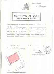 Melbourne Legacy
Certificate - Title Deed, Certificate of Title under the "Transfer of Land Act 1954", 1956
Junior Legacy Melbourne purchased 293 Swanston Street Melbourne in 1956 from the Commonwealth Government of Australia with money gifted to Legacy in memory of David Dureau. The title deed is in the name of Junior Legacy Melbourne, which was then working from 45 Market Street. Junior Legacy became Legacy Melbourne, and ultimately Melbourne Legacy, and as such is still using the three floors of the building.For over 60 years Melbourne Legacy has been able to conduct activities and fund raising for beneficiaries from this building; the facilities have been sufficiently extensive to enable complete flexibility in meeting the changing requirements.Double sided sheet of heavy white/cream paper, printed in black ink with plan drawn in red.01283.1 A216948 D.A. Tregent written in pencil 01383.2 3373, 571 and A216948 handwritten in blue/black inkproperties, dureau house -
 Melbourne Legacy
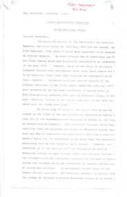
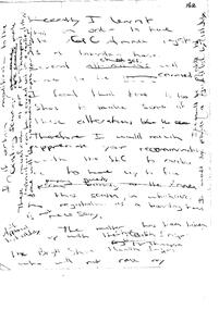
Document, Topic 1 - "How wide the beam?": Introductory statistical paper
1973 comprehensive statistical survey of likely numbers of Legatees, widows and children projected for 15 years, by W.K. Roberts, an Actuary at AMP, Melbourne. This was commissioned in order to consider the future of Legacy at a meeting in Hobart on March 24, 1973. The paper is identified as Appendix E, but the document it is appended to is missing. For the first time figures included the post 1945 conflicts, making the decline in child numbers more gradual, increasing the widow numbers more steeply, and predicting that Legatee numbers would be maintained until 1983 with the caveat that their capacity would change as they aged. Pinned to the printed survey is an anonymous handwritten note giving the number of children in residence at Harelands, Stanhope and Blamey House in 1972-4.Part of the history of Melbourne Legacy's involvement with residential care for children, indicating their awareness of the need to plan for the future.01666.1 White printed double sided sheets, black on white. 01666.2 Yellow copy paper with handwritten text in blue ink. residences, review, blamey house, harelands, stanhope -
 Melbourne Legacy
Document - Report, Future Requirements Committee: third and final report (H53), 1978
A report by the Future Requirements Committee dated 11 October 1978. The Committee members were(Chairman): I.W. Anderson, E. Cohen, A.N. Kemsley, L.D. King, J.M. Poulton, R.L. Simmons The Committee notes that its recommendations would probably be resisted by some Legatees but were necessary to meet the changing needs of dependants. They highlighted cancelling the supply of firewood, cessation in 1978 of the Badge Day appeal in Melbourne and the special Christmas promotion, and the Christmas Garden Party at Government House. Boys and Girls classes to be phased out, and Blamey House and Stanhope residences to be closed in 1979-80, with dental care to cease in 1980. They also recommended that more use should be made of labour available from ALL Legatees, and Legacy staff should be strictly monitored as the changes were brought into effect.After two World Wars, Melbourne Legacy recognised that the need for their traditional services was changing and they needed to be vigilant about the transparency of their expenditure.5 photocopied foolscap pages - poor qualityPage 1: 'Copy President from ER' in red ballpoint, 'H53' in blue ball point, 'B' in black.review committee, planning -
 City of Kingston
Pamphlet - Colour, Arthur Tuckett & Son, Auctioneers and Subdivisional Specialists, Auction of Station Estate, Moorabbin, 1923
Sales plan for land in the suburb of Moorabbin, bounded by Railway Crescent, South Road, Jasper Road and Pattersons Road.The developing urban area of Moorabbin within the City of Kingston. This land sale pamphlet illustrates the subdivision of land within the municipality and the changing demographic of the district as new houses are constructed.Colour pamphlet advertising an auction of the Station Estate Moorabbin. Incorporates details of the shopping facilities, proximity to the railway line, variety of schools and churches in the area, and a sales plan for home sites and shop fronts. Incorporates a map of the estate bordered by Pattersons Road, Japer Road, South Road and Railway Crescent. Handwritten in grey pencil top right front page: Station Estate / late [indecipherable] Handwritten in red pencil on subdivision map: x [on majority of properties marked on the map] Handwritten in grey pencil on subdivision map: additional subdivisions drawn in and large lines drawn across the mapmoorabbin, land sales, estate -
 Falls Creek Historical Society
Document - Hand-Written Note In Pencil - Annexe Register As Boarding House
Bob (Herman) Hymans (a former member of the Royal Netherlands Navy) was born in Bloemendaal, Holland on 30th September 1922. During World War II he fought against the Japanese in the Dutch East Indies (now Indonesia) and was imprisoned in Changi and on the Burma Railway. After gaining qualifications as a Ski Instructor, Bob arrived in Falls Creek in July 1950. Working as an Instructor and Supervisor at Bogong Lodge, Bob decided his future was in accommodation. He was successful in negotiating an indenture for land from the State Electricity Commission (SEC). It took Bob two years to build his Grand Coeur Chalet but, tragically, it was burned down in August 1961. Bob also built the first Chairlift in Australia. This was a single chairlift and the structure was built from wooden electricity poles. He was constantly full of new ideas and proposals for the village. Bob Hymans died on 7th July 2007. This Collection of documents and letters tells the story of Bob's endeavours to develop Falls Creek into the ski village it is today.This item is significant because it documents proposals put forward by Bob Hymans to develop facilities in the Falls Creek Tourist Area.A note, probably a draft of a letter, discussing plans by Bob Hymans to convert his annexe to be officially registered as a boarding house. The issue has been discussed with the Health Inspector at Bright. Necessary modifications before the start of the next season. He was seeking permission to have up to 5 lodgers stay during the current year, with further changes to be made for further expansion to satisfy Health Department requirements. Mr. Hymans was asking the Management Committee for support by putting this recommendation to the State Electricity Commission.falls creek tourist area management committee, falls creek administration, bob hymans -
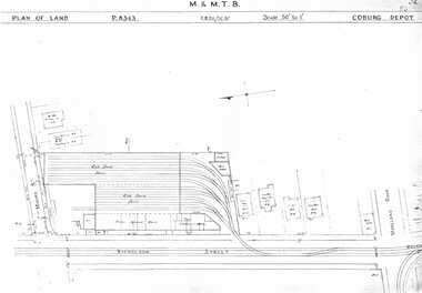 Melbourne Tram Museum
Drawing, Melbourne & Metropolitan Tramways Board (MMTB), "Coburg Depot", c1937
Set of two photocopied plans or drawings on A3 sheet of Coburg Depot - c1937 .1 - P8343 - Plan showing depot block and building plan with adjacent private houses and properties .2 - P8344 - Detail plan of depot - with notes about possible plans and changes - 4/1967. shows substation location.trams, tramways, drawings, depots, property, coburg depot, substation -
 Bendigo Historical Society Inc.
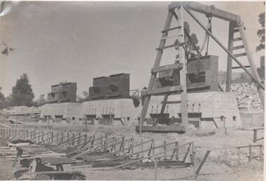
Photograph - Napoleon Reef Gold Mine Battery Site, 1936
The Napoleon (BML) gold mine (1932) was located near McDougall Road, Golden Gully, between Martin and Hattam Street. It had a depth of 921 feet. It was one of the latest and most lavish of Bendigo's mines. Plant and equipment were electrically driven. The four-compartment shaft, extra large by goldfield's standards, measured 17 feet 6 inches by 5 feet 2 inches and was cement lined below 900 feet instead of being red gum boxed as was the usual practice. The workshop was equipped to carry out all repairs for the equally lavish BML mines on the Nell Gwynne and Carshalton reefs. (The Gold Mines of Bendigo, Book 2, Arthur Victor Palmer) 'Napoleon BML Mines No Liability have issued a report for the fortnight ended September 5, where it states that the development scheme has been formulated and necessary equipment is being ordered. The Napoleon main shaft, (about 1700 feet south of the old Napoleon shaft) will be a four compartment shaft (17ft 6 inches by ft 2 inches inside the timber). aLevels will be opened at approximately 100 ft vertical intervals and cross-cuts extended approximately 125 ft each side of centre country to explore a cross-section across the anticline opposite to the shaft. At every fifth level, main drives will be extended north to connect with the old Napoleon shaft and south approximately 1800 ft. At the latter point, another cross-section of the anticline will be explored by rising and cross-cutting. The old Napoleon will be unwatered and on the 500ft and 1000 ft levels main drives will be driven to connect with main levels from the Napoleon main shaft to the south as well as being driven north 1800 ft where another cross-section of the anticline will be explored. Cross-sections further north and south may be developed as desired and also at intermediate points if necessary. Clearing and grading of the main shaft site are now in progress and the erection of the office and store building is proceeding. The design of engine room, change house and machine shops is now in hand and erection will proceed as soon as working plans and specifications are prepared.' The main shaft has been commenced at 3ft and advanced 10 ft. to 13 ft. https://trove.nla.gov.au/newspaper/article/10975478?searchTerm=napoleon%20bml (The Argus, 8th. September 1934, 'Mining' page 18) Significant to mining history of Bendigo.Black and white photograph of a stamper head being lowered into position on the battery site of the Napoleon Reef Gold Mine. A wooden gantry supports the battery head as it being lowered. Three large concrete foundations are visible in immediate background, two of which have stampers already in position, the third stamper is being lowered onto the final foundation. In immediate foreground, 'boxing' is erected for future concrete pours. napoleon gold mine, napoleon reef gold mine