Showing 10923 items matching " plan."
-
 Melbourne Tram Museum
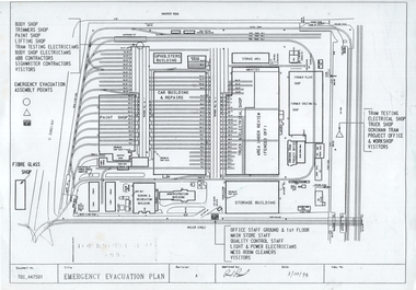
Document - Preston Workshops, Public Transport Corporation (PTC), Emergency Evacuation Plan", Oct. 1994
Plan dated 3/10/1994 shows the layout of the Preston Workshops tracks, buildings at the time and emergency evacuation assembly points. At the time operated by the Public Transport Corporation with ABB Contractors and Goninan Tram Project Offices. Document Number T01_447501.Yields information about the layout of Preston Workshops in 1994.Photocopy of an A4 plan or document.tramways, trams, preston workshops, floor plans, track plans -
 Federation University Historical Collection
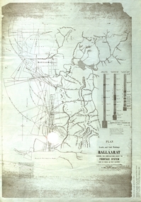
Plan, Plan of Leads and Gold Workings at Baallarat Shewing the Complications Under the Frontage System, 1863, 1863
Facsimile of a plan held by the Public Record Office Victoria. Facsimile of a plan of Ballarat showing leads, gold workings an dthe frontage system.ballarat, mining, inkermann lead, golden point lead, robert davidson, terrible lead, white horse lead, frenchman's lead, little magpie lead, milkmaid's lead, woolshed lead, nuggety lead, blackman's lead, canadian lead, sailor's gully lad, nightingale lead, malakoff lead, black hill gully, pennyweight flat, black hill, winter's pre-emptive right, nelson company, great extended, great republic lead, cgt -
 Greensborough Historical Society
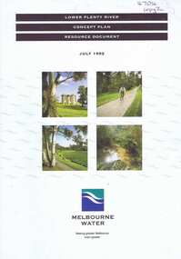
Book, Lower Plenty River concept plan: resource document, 1992_07
Draft concept plan prepared by Brett Cheatley, Malcolm Warren and Ian Womersley, Parks and Waterways Planning Division, Melbourne Water. This document includes information on the heritage and environment of the Lower Plenty River.Book, mainly black and white, colour photographs and plans, 56 pages, 3 copies.plenty river, melbourne water, lower plenty river -
 Clunes Museum
Plan - Building Plans, Proposed Layout Plan Clunes Neighborhood House, 12 June 2009
Architectural plan of proposed Clunes Neighborhood House Free Lending Library Development.A1 size architectural plan of proposed Clunes Neighborhood House Free Lending Library Development. Includes floor plan, front and side elevations. Dated 12 June 2009 by Kevyn Joy Architects.clunes neighbourhood house, kevyn joy architects, building plans -
 Kew Historical Society Inc
Plan, Melbourne & Metropolitan Board of Works : Borough of Kew : Detail Plan No.1578, 1904
The Melbourne and Metropolitan Board of Works (MMBW) plans were produced from the 1890s to the 1950s. They were crucial to the design and development of Melbourne's sewerage and drainage system. The plans, at a scale of 40 feet to 1 inch (1:480), provide a detailed historical record of Melbourne streetscapes and environmental features. Each plan covers one or two street blocks (roughly six streets), showing details of buildings, including garden layouts and ownership boundaries, and features such as laneways, drains, bridges, parks, municipal boundaries and other prominent landmarks as they existed at the time each plan was produced. (Source: State Library of Victoria). This plan forms part of a large group of MMBW plans and maps that was donated to the Society by the Mr Poulter, City Engineer of the City of Kew in 1989. Within this collection, thirty-five hand-coloured plans, backed with linen, are of statewide significance as they include annotations that provide details of construction materials used in buildings in the first decade of the 20th century as well as additional information about land ownership and usage. The copies in the Public Record Office Victoria and the State Library of Victoria are monochrome versions which do not denote building materials so that the maps in this collection are invaluable and unique tools for researchers and heritage consultants. A number of the plans are not held in the collection of the State Library of Victoria so they have the additional attribute of rarity.Original survey plan, issued by the MMBW to a contractor with responsibility for constructing sewers in the area identified on the plan within the Borough of Kew. The plan was at some stage hand-coloured, possibly by the contractor, but more likely by officers working in the Engineering Department of the Borough and later Town, then City of Kew. The hand-coloured sections of buildings on the plan were used to denote masonry or brick constructions (pink), weatherboard constructions (yellow), and public buildings (grey). MMBW Plan No.1578 is significant in that it defines the extent of two private schools: Xavier College and Kew High School (now part of Trinity Grammar) by 1904. In relation to the latter, the plan clarifies which buildings the High School operated from behind the mansion ‘Molina’. Established in 1902, Trinity Grammar was to later lease and subsequently buy Molina (now ‘Merritt House’) and ‘Elsinore’ (now ‘Roberts House’). Xavier College had been established in 1872. This 1904 plan delineates the West Wing and the Great Hall (built in 1890).melbourne and metropolitan board of works, detail plans, maps - borough of kew, mmbw 1578, cartography -
 Kew Historical Society Inc
Plan, Melbourne & Metropolitan Board of Works : Borough of Kew : Detail Plan No.1590, 1905
The Melbourne and Metropolitan Board of Works (MMBW) plans were produced from the 1890s to the 1950s. They were crucial to the design and development of Melbourne's sewerage and drainage system. The plans, at a scale of 40 feet to 1 inch (1:480), provide a detailed historical record of Melbourne streetscapes and environmental features. Each plan covers one or two street blocks (roughly six streets), showing details of buildings, including garden layouts and ownership boundaries, and features such as laneways, drains, bridges, parks, municipal boundaries and other prominent landmarks as they existed at the time each plan was produced. (Source: State Library of Victoria)This plan forms part of a large group of MMBW plans and maps that was donated to the Society by the Mr Poulter, City Engineer of the City of Kew in 1989. Within this collection, thirty-five hand-coloured plans, backed with linen, are of statewide significance as they include annotations that provide details of construction materials used in buildings in the first decade of the 20th century as well as additional information about land ownership and usage. The copies in the Public Record Office Victoria and the State Library of Victoria are monochrome versions which do not denote building materials so that the maps in this collection are invaluable and unique tools for researchers and heritage consultants. A number of the plans are not held in the collection of the State Library of Victoria so they have the additional attribute of rarity.Original survey plan, issued by the MMBW to a contractor with responsibility for constructing sewers in the area identified on the plan within the Borough of Kew. The plan was at some stage hand-coloured, possibly by the contractor, but more likely by officers working in the Engineering Department of the Borough and later Town, then City of Kew. The hand-coloured sections of buildings on the plan were used to denote masonry or brick constructions (pink), weatherboard constructions (yellow), and public buildings (grey). Surveyed by the Board of Works in 1903 and published in 1904, Plan No.1590 shows development north of Cotham Road. While this plan includes built structures in Mary Street, Cotham Road, High Street, Park Hill Road, Kent Street, Ridgeway Avenue, and Ermington Lane (now Ermington Place), only part of this section was notated and coloured in this contractor’s copy. Numerous houses, large and small are named on the plan: ‘Cholula’, ‘Belper’, ‘The Uplands’, ‘Spring Grove’ facing Cotham Road; ‘Marion’ facing Kent Street; and ‘Kia Ora’ facing Ridgeway Avenue.melbourne and metropolitan board of works, detail plans, mmbw 1590, survey plans - borough of kew, cartography -
 Kew Historical Society Inc
Plan, Melbourne & Metropolitan Board of Works : Borough of Kew : Detail Plan No.1302, 1910
The Melbourne and Metropolitan Board of Works (MMBW) plans were produced from the 1890s to the 1950s. They were crucial to the design and development of Melbourne's sewerage and drainage system. The plans, at a scale of 40 feet to 1 inch (1:480), provide a detailed historical record of Melbourne streetscapes and environmental features. Each plan covers one or two street blocks (roughly six streets), showing details of buildings, including garden layouts and ownership boundaries, and features such as laneways, drains, bridges, parks, municipal boundaries and other prominent landmarks as they existed at the time each plan was produced. (Source: State Library of Victoria)This plan forms part of a large group of MMBW plans and maps that was donated to the Society by the Mr Poulter, City Engineer of the City of Kew in 1989. Within this collection, thirty-five hand-coloured plans, backed with linen, are of statewide significance as they include annotations that provide details of construction materials used in buildings in the first decade of the 20th century as well as additional information about land ownership and usage. The copies in the Public Record Office Victoria and the State Library of Victoria are monochrome versions which do not denote building materials so that the maps in this collection are invaluable and unique tools for researchers and heritage consultants. A number of the plans are not held in the collection of the State Library of Victoria so they have the additional attribute of rarity.Original survey plan, issued by the MMBW to a contractor with responsibility for constructing sewers in the area identified on the plan within the Borough of Kew. The plan was at some stage hand-coloured, possibly by the contractor, but more likely by officers working in the Engineering Department of the Borough and later Town, then City of Kew. The hand-coloured sections of buildings on the plan were used to denote masonry or brick constructions (pink), weatherboard constructions (yellow), and public buildings (grey). The absence of buildings and or property in Kew facing the Yarra is the most notable feature of this plan. Walmer Street and its bridge stretched, then and now, from Studley Park Road to Victoria Street, Richmond. On the Richmond side of the Yarra, there was evidence in 1904 of industry (‘Wool shed’; Soap Works’) and entertainment (‘Skittle Alley’). In reality, another Plan (No.1303) shows Chinese Gardens bordering the Yarra on the Kew side and buildings in Young Street.melbourne and metropolitan board of works, detail plans, mmbw 1302, cartography -
 Greensborough Historical Society
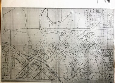
Map, City of Heidelberg, Subdivision plan of Greensborough, 1965c
Subdivision plan of Greensborough including Briar Hill and Greenhills. Supplied by Bill Cecil whose parents owned the Greensborough Post Office and it is assumed that these maps were used by Bill (who delivered the post on horseback) to keep up to date with the growing number of new streets and housing in Greensborough.Copies of subdivision plan for Greensboroughgreensborough, briar hill, greenhills -
 Greensborough Historical Society
Book, Lower Plenty River concept plan: prescription document, 1992_07
Draft concept plan prepared. by Brett Cheatley, Malcolm Warren and Ian Womersley, Parks and Waterways Planning Division, Melbourne Water. Includes management areas and key strategies for the Lower Plenty River.Book, mainly black and white print, colour photographs and plans, 66 pages. 3 copiesplenty river, melbourne water, lower plenty river -
 Federation University Historical Collection
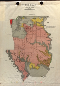
Map - Plan, E.J. Dunn, Bungal County of Grant Parish Plan
E.J. Dunn was the surveyor of this parish plan.Colour geological plan of Bungal in the County of Grant, Victoria. The areas circled in red ar craters.plan, bungal, bungeltap, black horse co. egerton, egerton, mount egerton, sister rose shaft, south learmonth co, kerrit bareet, bungaeeltap, yaloak, eastern moorabool river, corong, bungal station preemptive right, lal lal, western moorabool river, moorabool rover, borhoneychurck, mount egerton battery, bungal creek -
 Kew Historical Society Inc
Plan, Melbourne and Metropolitan Board of Works, Melbourne & Metropolitan Board of Works : Borough of Kew : Detail Plan No.1294 & 1295, 1904
The Melbourne and Metropolitan Board of Works (MMBW) plans were produced from the 1890s to the 1950s. They were crucial to the design and development of Melbourne's sewerage and drainage system. The plans, at a scale of 40 feet to 1 inch (1:480), provide a detailed historical record of Melbourne streetscapes and environmental features. Each plan covers one or two street blocks (roughly six streets), showing details of buildings, including garden layouts and ownership boundaries, and features such as laneways, drains, bridges, parks, municipal boundaries and other prominent landmarks as they existed at the time each plan was produced. (Source: State Library of Victoria). This plan forms part of a large group of MMBW plans and maps that was donated to the Society by the Mr Poulter, City Engineer of the City of Kew in 1989. Within this collection, thirty-five hand-coloured plans, backed with linen, are of statewide significance as they include annotations that provide details of construction materials used in buildings in the first decade of the 20th century as well as additional information about land ownership and usage. The copies in the Public Record Office Victoria and the State Library of Victoria are monochrome versions which do not denote building materials so that the maps in this collection are invaluable and unique tools for researchers and heritage consultants. A number of the plans are not held in the collection of the State Library of Victoria so they have the additional attribute of rarity.Original survey plan, issued by the MMBW to a contractor with responsibility for constructing sewers in the area identified on the plan within the Borough of Kew. The plan was at some stage hand-coloured, possibly by the contractor, but more likely by officers working in the Engineering Department of the Borough and later Town, then City of Kew. The hand-coloured sections of buildings on the plan were used to denote masonry or brick constructions (pink), weatherboard constructions (yellow), and public buildings (grey).The streets and built structures in MMBW Detail Plan 1294 & 1295 were surveyed in 1903 and released to contractors in 1904. This plan is one of two in the collection where the lithographers amalgamated two separate plans. Both plans include sections of Studley Park. Dominating the south and west corners of Kew Junction are the Clifton and Kew Hotels. The Kew Hotel, owned by Patrick O’Shaughnessy was one of the oldest in Kew. MMBW plans were amended over time to take account of new subdivisions such as that which created Merrion Place. Of the four mansions shown in Studley Park Road, three remain – ‘Field Place’, the home of Frances Henty, ‘Leaghur’ and ‘Darley’. ‘Byram’ (later ‘Goathland’, then ‘Tara Hall’) was an architectural marvel. Designed in 1888 by E.G. Kilburn for the paper magnate George Ramsden, it was demolished in 1960. While an earlier sale of the southern section of Byram had created Tara Avenue in 1927, the demolition of the house in 1960 enabled the extension of Tara Avenue northward.melbourne and metropolitan board of works, detail plans, mmbw 1294, mmbw 1295, cartography -
 Yarra Ranges Regional Museum
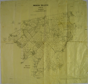
Map, H J Green, Acting Govt. Printer, Wandin Yallock, County of Evelyn (Parish Plan), c. 1910 - 1920
Parish Plan of Wandin Yallock. Location of Silvan Reservoir marked in ink on map.Parish Plan of Wandin Yallock. Location of Silvan Reservoir marked in ink on map. wandin yallock, maps -
 Kew Historical Society Inc
Plan, Melbourne & Metropolitan Board of Works / Borough of Kew, Detail Plan No.1593, 1905
The Melbourne and Metropolitan Board of Works (MMBW) plans were produced from the 1890s to the 1950s. They were crucial to the design and development of Melbourne's sewerage and drainage system. The plans, at a scale of 40 feet to 1 inch (1:480), provide a detailed historical record of Melbourne streetscapes and environmental features. Each plan covers one or two street blocks (roughly six streets), showing details of buildings, including garden layouts and ownership boundaries, and features such as laneways, drains, bridges, parks, municipal boundaries and other prominent landmarks as they existed at the time each plan was produced. (Source: State Library of Victoria)This plan forms part of a large group of MMBW plans and maps that was donated to the Society by the Mr Poulter, City Engineer of the City of Kew in 1989. Within this collection, thirty-five hand-coloured plans, backed with linen, are of statewide significance as they include annotations that provide details of construction materials used in buildings in the first decade of the 20th century as well as additional information about land ownership and usage. The copies in the Public Record Office Victoria and the State Library of Victoria are monochrome versions which do not denote building materials so that the maps in this collection are invaluable and unique tools for researchers and heritage consultants. A number of the plans are not held in the collection of the State Library of Victoria so they have the additional attribute of rarity.Original survey plan, issued by the MMBW to a contractor with responsibility for constructing sewers in the area identified on the plan within the Borough of Kew. The plan was at some stage hand-coloured, possibly by the contractor, but more likely by officers working in the Engineering Department of the Borough and later Town, then City of Kew. The hand-coloured sections of buildings on the plan were used to denote masonry or brick constructions (pink), weatherboard constructions (yellow), and public buildings (grey). The laborious task of hand-tinting these Board of Works plans was not without hazards as is evidenced by Plan No. 1593. On the Plan, the original colourist spilt black and green ink, partially obscuring some parts. The most obvious casualty is ‘Clifton’ located on the corner of Cotham Road and Park Street [now Adeney Avenue]. Included in this Plan, and outlined in pink is that part of the section that the contracting engineer was tasked with completing. This included sewering on both sides of this part of Cotham Road, but excluded properties such as ‘Glendonald’ and ‘Monnington’. This area was to undergo a series of subdivisions including the ‘Clifton Estate’, which created housing lots on Adeney Avenue and Florence Avenue in 1916. The most notable occupant of Clifton was William Adeney [died 1893], a pioneer of Camperdown, after which Park Street was later renamed.melbourne and metropolitan board of works, detail plans, survey plans - borough of kew, mmbw 1593, cartography -
 Kew Historical Society Inc
Plan, Melbourne & Metropolitan Board of Works : Borough of Kew : Detail Plan No.1291, 1905
The Melbourne and Metropolitan Board of Works (MMBW) plans were produced from the 1890s to the 1950s. They were crucial to the design and development of Melbourne's sewerage and drainage system. The plans, at a scale of 40 feet to 1 inch (1:480), provide a detailed historical record of Melbourne streetscapes and environmental features. Each plan covers one or two street blocks (roughly six streets), showing details of buildings, including garden layouts and ownership boundaries, and features such as laneways, drains, bridges, parks, municipal boundaries and other prominent landmarks as they existed at the time each plan was produced. (Source: State Library of Victoria). This plan forms part of a large group of MMBW plans and maps that was donated to the Society by the Mr Poulter, City Engineer of the City of Kew in 1989. Within this collection, thirty-five hand-coloured plans, backed with linen, are of statewide significance as they include annotations that provide details of construction materials used in buildings in the first decade of the 20th century as well as additional information about land ownership and usage. The copies in the Public Record Office Victoria and the State Library of Victoria are monochrome versions which do not denote building materials so that the maps in this collection are invaluable and unique tools for researchers and heritage consultants. A number of the plans are not held in the collection of the State Library of Victoria so they have the additional attribute of rarity.Original survey plan, issued by the MMBW to a contractor with responsibility for constructing sewers in the area identified on the plan within the Borough of Kew. The plan was at some stage hand-coloured, possibly by the contractor, but more likely by officers working in the Engineering Department of the Borough and later Town, then City of Kew. The hand-coloured sections of buildings on the plan were used to denote masonry or brick constructions (pink), weatherboard constructions (yellow), and public buildings (grey). A detail plan of part of Studley Park bordered by the major streets of Hodgson Street, Stevenson Street and Studley Park Road. Included on the plan are a number of significant Studley Park mansions in existence at the beginning of the 20th century. The unnamed street shown in the middle of the plan is McEvoy Street. The most important house still extant is Campion House, formerly named Dalsraith [Dalswraith] and Glendalough, owned since the 1940s by the Society of Jesus. Campion House can be seen on the corner of Hodgson and Studley Park Road. Its stables at the rear of the block have now been incorporated into a contemporary residence. An interesting feature of the plan is the 1910 annotation by Ed Seitz, professional designing engineer. Is Seitz the contractor who modified the MMBW original?melbourne and metropolitan board of works, detail plans, mmbw 1291, cartography -
Federation University Historical Collection
Plan - Main Street Plan, John Carruthers, Plan of Main Street Ballarat done by J Carruthers 1858, 1858
This is an Historical plan of Ballarat and gives us a look back in time.long thin hand drawn plan of Main Street Ballarat on brown wax paper.j carruthers, main st, main street, free trade hotel, eureka street, specimen hill road, humffray street, star hotel, old kaiser hotel, golden age hotel, royal mail hotel, john carruthers -
 Greensborough Historical Society
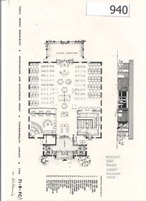
Plan, Watsonia High School Library: floor plan 1971, 1971_
In the early 1970s "Commonwealth Libraries" were funded in secondary schools. This is the proposed plan for the Watsonia High School Library.An example of school library plans from the 1970s.3 copies of a one-page floor plan and front elevation of building.Written on front "Watsonia"watsonia high school, commonwealth libraries -
 Kew Historical Society Inc
Plan, Melbourne & Metropolitan Board of Works : Borough of Kew : Detail Plan No.1350, 1910
The Melbourne and Metropolitan Board of Works (MMBW) plans were produced from the 1890s to the 1950s. They were crucial to the design and development of Melbourne's sewerage and drainage system. The plans, at a scale of 40 feet to 1 inch (1:480), provide a detailed historical record of Melbourne streetscapes and environmental features. Each plan covers one or two street blocks (roughly six streets), showing details of buildings, including garden layouts and ownership boundaries, and features such as laneways, drains, bridges, parks, municipal boundaries and other prominent landmarks as they existed at the time each plan was produced. (Source: State Library of Victoria). This plan forms part of a large group of MMBW plans and maps that was donated to the Society by the Mr Poulter, City Engineer of the City of Kew in 1989. Within this collection, thirty-five hand-coloured plans, backed with linen, are of statewide significance as they include annotations that provide details of construction materials used in buildings in the first decade of the 20th century as well as additional information about land ownership and usage. The copies in the Public Record Office Victoria and the State Library of Victoria are monochrome versions which do not denote building materials so that the maps in this collection are invaluable and unique tools for researchers and heritage consultants. A number of the plans are not held in the collection of the State Library of Victoria so they have the additional attribute of rarity.Original survey plan, issued by the MMBW to a contractor with responsibility for constructing sewers in the area identified on the plan within the Borough of Kew. The plan was at some stage hand-coloured, possibly by the contractor, but more likely by officers working in the Engineering Department of the Borough and later Town, then City of Kew. The hand-coloured sections of buildings on the plan were used to denote masonry or brick constructions (pink), weatherboard constructions (yellow), and public buildings (grey). MMBW Plan No. 1350 depicts the western end of Studley Park on the north side of the Studley Park Road. ‘Raheen’, then the home of Sir Henry Wrixon is named, the plan identifying those parts of the house that were built of brick and timber. The two houses between Raheen and the River Yarra are also shown. Other parts of the plan show neighbouring streets: Yarra Street, Studley Park Avenue, Studley Street and Fenwick Street. Each, apart from Fenwick Street was subsequently renamed. At the corner of Fenwick and Stawell Streets, the home of Joseph Butterworth Coombs, later called ‘Hope Mansell’, is represented but unnamed.melbourne and metropolitan board of works, detail plans, mmbw 1350, cartography -
 Rutherglen Historical Society
Aperture Card microfilm, Victorian Land Tiltes Office, Parish Plan Barnawartha North Schedule (Duplicate)
Town layout of Barnawarthacard with a single microfilm insertMetric Planschedule -
 Rutherglen Historical Society
Aperture Card microfilm, Victorian Land Tiltes Office, Parish Plan Barnawartha North Schedule
Town layout of Barnawarthacard with a single microfilm insertMetric Planschedule -
 Greensborough Historical Society
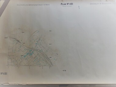
Map, Melbourne & Metropolitan Board of Works, MMBW Plan No.481, 23/09/1949
MMBW plan of part of central Greensborough, Main Street and surrounds, from sports ovals in North to Grimshaw Street in South.Map shows buildings and topography for the area.MMBW plan, black and colour ink on beige parchment, 2 copies."Scale:160 feet to 1 inch"melbourne and metropolitan board of works, mmbw, greensborough -
 Kew Historical Society Inc
Plan, Survey Plan, Park Hill Road, Kew, 1880-1890
The streets identified on the survey plan - Cotham Road, Park Hill Road East, Park Hill Road West in Kew were each gazetted by the Victorian Government in 1865. The hand-coloured survey plan was completed by Holland Loxton, Town Clerk and Surveyor of the Borough of Kew from 1866. The unnamed survey plan includes names of land owners in addition to measurements (2 chains to 1 inch) and streets. Named owners include Webster, Payne and Francom which will enable us to narrow down the creation date of the survey.Handdrawn survey plan by a former surveyor and town clerk of KewHand drawn and coloured survey plan created by Holland Loxton, Surveyor and Town Clerk of Kew, showing land owned by Payne in Park Hill Road, Kew. The plan includes street names, land measurements and land owners.surveys - kew, maps - kew, holland loxton, park hill road - kew, holland loxton -- surveyor, survey plans -- parkhill road -- kew (vic.) -
 Federation University Historical Collection
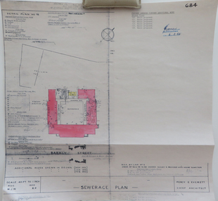
Plan, Plan (dyeline): Ballarat Girls' School Sewerage Plan, 1950
Plan (dyeline) for Ballarat Girls' School sewerage plan percy everett, ballarat girls' school, sewerage plans -
 Greensborough Historical Society
Plan, Plan of Manatunga Circuit Greensborough subdivision, 1970_
Plan of Manatunga Circuit subdivision. Prepared by O'Connor and Beveridge (land surveyors) for Development Underwriting (developers). Plan of subdivision. Part of Crown Portion 3. Parish of Nillumbik, County of Evelyn.An original example of a subdivision plan in the expanding suburb of Greensborough. The 1960s and 1970s saw this area develop from a rural farming area to a suburb.Plan of subdivision. Printed on buff paper, hand coloured. Mounted on cardboard. Includes 2 small cards attached.Various handwritten comments. Small cards from Survey Branch, Office of Titles.greensborough, manatunga circuit, diamond creek road, plenty river drive -
 Kew Historical Society Inc
Plan, Melbourne & Metropolitan Board of Works : Borough of Kew : Detail Plan No.1301, 1910
The Melbourne and Metropolitan Board of Works (MMBW) plans were produced from the 1890s to the 1950s. They were crucial to the design and development of Melbourne's sewerage and drainage system. The plans, at a scale of 40 feet to 1 inch (1:480), provide a detailed historical record of Melbourne streetscapes and environmental features. Each plan covers one or two street blocks (roughly six streets), showing details of buildings, including garden layouts and ownership boundaries, and features such as laneways, drains, bridges, parks, municipal boundaries and other prominent landmarks as they existed at the time each plan was produced. (Source: State Library of Victoria)This plan forms part of a large group of MMBW plans and maps that was donated to the Society by the Mr Poulter, City Engineer of the City of Kew in 1989. Within this collection, thirty-five hand-coloured plans, backed with linen, are of statewide significance as they include annotations that provide details of construction materials used in buildings in the first decade of the 20th century as well as additional information about land ownership and usage. The copies in the Public Record Office Victoria and the State Library of Victoria are monochrome versions which do not denote building materials so that the maps in this collection are invaluable and unique tools for researchers and heritage consultants. A number of the plans are not held in the collection of the State Library of Victoria so they have the additional attribute of rarity.Original survey plan, issued by the MMBW to a contractor with responsibility for constructing sewers in the area identified on the plan within the Borough of Kew. The plan was at some stage hand-coloured, possibly by the contractor, but more likely by officers working in the Engineering Department of the Borough and later Town, then City of Kew. The hand-coloured sections of buildings on the plan were used to denote masonry or brick constructions (pink), weatherboard constructions (yellow), and public buildings (grey). Throughout its history, the land in what is known today as Studley Ward of the City of Boroondara has been subject to continuing subdivision. This is evident in Plan 1301, where later hands have modified the original map to include streets created subsequent to the printing of the plan in 1904. Other annotations such as the ‘Reserved for Road Purposes’ beside the Yarra never eventuated. The plan continued to be modified to at least 1953, when a later hand noted that a particular site was ‘Property site P. McIntyre house’ in Swinton Avenue. Two significant houses in the area are outlined on the plan: ‘Swinton’ on the corner of the streets then named Effey and Maud Streets (now Swinton Avenue) and ‘Fairhaven’ [unnamed] in Stevenson Street. The gardens of the two David Syme owned mansions of ‘Blythswood’ and ‘Rockingham’, stretching down to the River Yarra, are also represented.melbourne and metropolitan board of works, detail plans, mmbw 1301, cartography -
 RMIT Design Archives
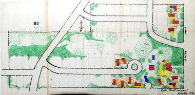
Work on paper - Architectural drawings, Colour plan of Lum road estate, 1970-1986
This plan of Lum Road Estate includes layout of roads, gardens, building and carparks. From 1970 until August 1971 Robin Boyd and his practice Romberg & Boyd Architects worked on designs for housing on the Lum Road Estate, Wheelers Hill. Berenice Harris, Linley Vellacott and Karl Fender drew many of the sketch plans for the project homes, while Robin Boyd drew the perspectives. This colour plan of the estate was drawn by Robin Boyd, but not signed. Frederick Romberg later annotated the drawing with details of its authorship. Colour plan of Lum road estate. Includes layout of roads, gardens, buildings and flora.Inscribed lower right on recto in black ink, 'Robin Boyd original / 12/6/86 F.R' ; Inscriber upper left on recto, grey pencil, '3400'.architecture, design, rmit design archives, domestic architecture -
 Greensborough Historical Society
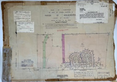
Poster - Planning Document, City of Heidelberg et al, Subdivision Plan # H 41 - Crown portion 8, Parish of Keelbundoora - Yallambie, and Crown Portion 9, Parish of Keelbundoora, 1922-1967
Planning Document: Subdivision Plan # H 41 Side 1, Crown portion 8, Parish of Keelbundoora - Yallambie Road, Allima Avenue, Koolya Court, Ekam Court (Jennings Estate). Side 2: Crown Portion 9, Parish of Keelbundoora consist of 5 small subdivision sheets: 1. Somers Avenue, Stewart Terrace, Toubay Street and Railway Place (no date); 2. Somers Avenue, Maxwell Street, Greensborough Road, 1924; 3. Heidelberg Avenue, Golf Avenue, St Andrews Avenue (no date); 4. Birdwood Avenue, May Street (no date); 5. Strathallan Road 1924.An example of hard copy subdivision plans from the Greensborough area. Mainly from the Shire of Diamond Valley era (1964-1994).Plan (2 sided) mounted on heavy card. Stamped and handwritten Council permissions, dates and other details.subdivision plans, city of heidelberg, yallambie, macleod, greensborough -
 Federation University Historical Collection
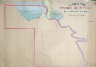
Plan, Plan of the Squires Mount Mercer Gold Mining Plant
This plan is associated with former Ballarat School of Mines Student Richard Squire (1875-1876). Gift of the Squire FamilyLarge plan paper on linen, scale of 150 feet to one inch. Handcoloured. mount mercer, squires mine, mining, gold mining, gold, plan -
 Greensborough Historical Society
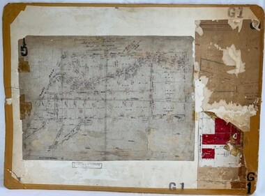
Poster - Planning Document, Shire of Diamond Valley, Subdivision Plan # G 1, Watsonia, 1962 and 1976
Plan of Subdivisions in Shire of Diamond Valley: Side 1: subdivision of LP5406 bounded by Plenty Road, Greensborough Road, Meakin Avenue, Watsonia and includes Aqueduct Road, 1976. Side 2: 2 plans - Keelbundoora: Morwell Avenue and Grace Street; Nillumbik: Inglis Street and Chute Street Diamond Creek, 1962An example of hard copy subdivision plans from the Greensborough area. Mainly from the Shire of Diamond Valley era (1964-1994).Plan (2 sided) mounted on heavy card. Contains 2 sheets pasted together.Stamped and handwritten Council permissions, dates and other details. subdivision plans, diamond creek, shire of diamond valley -
 Greensborough Historical Society
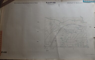
Map, Melbourne & Metropolitan Board of Works, MMBW Plan No.480, 17/10/1949
MMBW plan of part of central Greensborough, from Plenty River in North to Grimshaw Street in South, Sellars Street in West to Kerr Street in East.Map shows buildings and topography for the area.MMBW plan, black and colour ink on beige parchment, 4 copies."Scale:160 feet to 1 inch"melbourne and metropolitan board of works, mmbw, greensborough -
 Bacchus Marsh & District Historical Society
Map, Lerderderg Park Lands sale plan. 1911
This plan was for the sale of parcels of land from the Lerderderg Park Estate property in 1911. Advertising for the sale appeared in the Bacchus Marsh Express newspaper through July of 1911. The property was situated only a few kilometers from the township of Bacchus Marsh. The agents for the sale were L. A. Fairbairn & Co.Lerderderg Park Estate was a significant and early colonial property in the Bacchus Marsh area. This plan provides details about the first time the property was subdivided for sale. It is therefore documents an important moment in the history of this property and the broader trend of the subdivision of older and larger properties in the district.A single page paper plan showing allotments of land for sale from the Lerderderg Park property owned by John Wills. The parcels of land for sale are coloured in red.The Lerderderg River and Pyke's Creek Irigation Channel shown on the plan are in blue ink. The rest of the plan is a dark cream or beige colur with the text in black ink. The plan has been extensively annotated with hand-written notes indicating the names of people who purchased the various parcels of lands and the prices paid for those lands. Part of the top of the plan containing some text appears to be missing. The plan is pasted into a bound volume containing 76 maps or plans in total. Top: Have received instructions to Sell, account Mr John Wills, his renowned LERDERDERG PARK LANDS, so well and favourably known throughout the Commonwealth. In areas from 3 acres to 1276 acres. Every lot is either rich lucerne land (or portion now under lucerne) with some higher land adjoining Railway Station, and 2 Milk factories within 2 miles, absolutely the finest land in Victoria. Bottom: THIS IS THE FIRST SUBDIVISIONAL SALE of Rich Flats in Bacchus Marsh since the Pyke's Creek Scheme, and every lot is commanded by it. Only 32 miles from Melbourne.bacchus marsh victoria maps, land sales, lerderderg park estate, land subdivision