Showing 156 items matching "1 field regiment"
-
 4th/19th Prince of Wales's Light Horse Regiment Unit History Room
Photograph, Col Frank Pearson
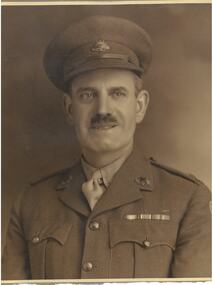
Francis Charles Pearson was born on 23rd August 1913 in Ballarat. During the course of his long life -he died just before his 96th birthday - he was a successful businessman, notably in the field of air conditioning, as well as a world renown farmer noted for his cattle breeding methods. This was in addition to a meritorious military career. Frank Pearson enlisted as a 16 year old cadet in 6 Field Company, Australian Engineers on 29 Jan 1930., CSM in 1935, he transferred to 2 Field Coy RAE on 1 July 1936. Next, he joined the cadre of 2 AA Searchlight Coy, RAE and was commissioned on 14 Oct 1939. That unit became 53rd AA Coy, providing personnel for 1/54 AA Coy late in 1939. Lt Pearson was was 2IC at this time. When the unit was mobilised on 14 Sep 1940, T/Capt Pearson was appointed OC. Seconded to the AIF on 14 May 1941 he was appointed to raise A Squadron, 2/6 Armoured Regiment, and once that was done, he raised B Squadron. Promoted temporary Major in June 1942 he served with the regiment in Stuart tanks during the difficult operations around Cape Endaiadere and Buna from October 1942 until April 1943. After return to Australia the regiment waited in vain for further operational employment. Frank Pearson was demobilised on 23 October 1945. With the raising of the Citizen Military Forces in 1948, Major Pearson was appointed 2IC 8th/13th Victorian Mounted Rifles. On 1 January 1953 he assumed command of 4th/19th Prince of Walers's Light Horse Regiment, a post he held until the end of 1956. After service in more senior postings he retired with the rank of Colonel on 24 August 1964. From then until just a few years before his passing, Colonel Pearson remained actively involved in the life of his regiment. Following a couple of less successful attempts to do so, he was instrumental in establishing the regimental museum, these days the Unit History Room. Undaunted by a continuing sequence of changing venues it is to his credit that the history of the regiment is not only preserved but readily available to today's members of the unit and the general public. Coloured photo of Colonel Francis (Frank) Pearson OAM ED. Mounted in wooden frame.frank pearson, photographs -
 Flagstaff Hill Maritime Museum and Village
Weapon - Cannon, 1866
In the years following the Crimean War (1854-1857J) there was a great concern in the Colony that Imperial Russia would attempt an invasion. Coastal defences in the colony of Victoria were greatly strengthened by the Government as a result. Warrnambool was originally protected by cannons at Cannon Hill, approximately 1 kilometer west of the Flagstaff Hill Fortifications. These cannons included two 1866 guns, both 80 Pound Rifled Muzzle Loaders (RML) purchased by Victoria’s Colonial Government. They were part of a shipment of 26 such guns sent from England in December 1866. They are registered as No. 23 (80cwt-2qr-0lbs) - Gun 1, and No.13 (81cwt-1qr-12lbs) - Gun 2. They were cast at the Royal Gun Factory, Woolwich Arsenal, in 1866 and have a 6.3 inch bore. Both barrels carry the Royal Cypher of Queen Victoria, Insignia of the Royal Engineers, within the Garter and Motto surmounted by the Crown, with the Royal Cypher of Queen Victoria within the Garter (letters in centre “VR”, motto “HONI SOIT QUI MAL Y PENSE”, "Shame be to him who thinks evil of it."). The guns were originally supplied with wooden carriages. (The Royal Arsenal at Woolwich, England, was established eleven years after the Restoration of King Charles II. It was the principal supplier of armaments to the British and Empire Governments. At the height of its operations during World War One the factory covered 1300 acres and employed very nearly 80,000 workers. Woolwich was the Headquarters of the Royal Artillery since the raising of that Regiment in 1716. The Arsenal was closed in the late 1960’s.) These two cannons were transferred to the Warrnambool Garrison Artillery Battery Fortifications erected at Flagstaff Hill in 1887 as part of Victoria’s Coastal Defences. The original wooden carriages were subsequently replaced with the present iron garrison carriages in 1888. They are a “C” pivot. The ‘racers’ or curved track set into the floor of the gun emplacement (which enabled the guns to be traversed more quickly) are as specified for guns up to 10 inch, being of wrought iron 2.78 inches wide. A temporary third gun, now no longer on Flagstaff Hill’s site, was a 5 inch Rifled Breech Loading (BL) Armstrong gun mounted on an Elswick hydro pneumatic disappearing carriage It was faster to load and fire than the 80 pound RMLs and its arrival spelt the end of the older 80 pound guns’ useful life, apart from being used for practice sessions. The 5 inch BL gun was the main defensive weapon of the Warrnambool Battery until the Battery was downgraded in importance and the gun was recalled to Melbourne in 1910. The State of Victoria took over the ownership of the guns at the time of Australian Federation in 1901. In about 1901/1902 the Garrison Battery was converted to the Warrnambool Battery of the Australian Field Artillery (No 4 Field Battery). It was equipped with 4.7 inch naval guns mounted on field carriages. They were now a mobile unit but continued to use the Warrnambool Garrison area at Flagstaff Hill for practice. When the Fortifications were declared obsolete the two 80 Pounder RML were relocated to Cannon Hill in 1910. On the outbreak of World War One the 4.7 inch guns were recalled to Melbourne, and the Battery was disbanded. Most of the personnel probably re-enlisted in the local 4th Australian Light Horse Regiment. The two 80 Pounder RML were moved back to the Fortifications in 1973. They were both fully restored by Army First Year Apprentices at the Ordinance Factory in Bendigo in time for the centenary year of the fortifications in 1987. The guns are capable of firing 80 pound (32.3kg) armour piercing exploding shells 3.65kms out to sea. They were original manned by volunteers before a paid Garrison was established. Now the Guns are again fired by volunteers on Special Event days. Since restoration the Gun Number 1 had been fired on a regular basis but Gun Number 2 hadn’t been fired since the mid 1990’s. In April 2015 Gun Number 2 was serviced in preparation for the firing of both cannons on the ANZAC Centenary commemorations on April 25th 2015. Other guns from the original Cannon Hill location were obsolete by the time the 1887 Warrnambool Garrison Artillery Battery was built. These guns are (1) a 32 Pounder Muzzle Loading Smooth Bore (SB) cast in 1813 at the famous Carron Foundry, number 80837 and now located in the Warrnambool Botanic Gardens (2) a 68 Pounder Muzzle Loading Smooth Bore cast in 1861 at the equally august Low Moor Foundry, number 10310 and now located on the lawn area at the entrance to Flagstaff Hill Maritime Village. Both of these guns are mounted on their original wooden garrison carriages. There are only seven 32 Pounder SB made by Carron and fifteen 68 Pounder SB made at Low Moor known to exist in the State of Victoria (Conservation Management Plan for Victorian Guns and Cannon, South Western Victoria, May 2008, ref W/F/05)The Warrnambool Garrison has been added to the Victorian Heritage Register H1250 “for its intact battery and guns, a strong reminder of Victoria’s wealth and determination to protect itself from the perceived threat of invasion in the 1880’s.” The City of Warrnambool is one of several custodians of a collection of artillery pieces of heritage significance at a state, national and international level. These pieces are directly related to the defence of south-west Victoria in the 19th century. The care and preservation come under the Heritage Act 1995. Cannon. 80 Pound Rifled Muzzle Loading (RML) Gun on iron carriage and slide, installed in the Battery at Flagstaff Hill’s Fortifications. Made in 1866 at the Royal Gun Factory (R-G-F), Woolich, England. Gun Reg No 13. Flagstaff Hill Garrison Gun 2 (Gun No. 2). Insignia of the Royal Engineers, and the weight of the gun, stamped on top of the gun’s barrel. There is a brass plate on the side of the gun with the details of 1987 restoration.Stamped into the metal on top of the barrel, Insignia of the Royal Engineers; Garter and Motto “HONI SOIT QUI MAL Y PENSE”, surmounted by the Crown, with the Royal Cypher of Queen Victoria “VR” within the Garter. Also stamped on top of the gun are 2 inward pointing arrows above the weight ”81-1-12”. Brass plate “RESTORATION / BY / FIRST YEAR / APPRENTICES / ORDANANCE FACTORY / BENDIGO 1987”flagstaff hill, warrnambool, shipwrecked coast, flagstaff hill maritime museum, maritime museum, shipwreck coast, flagstaff hill maritime village, great ocean road, colonial defences, victoria’s coastal defences, warrnambool fortification, warrnambool garrison battery, warrnambool volunteer corps, ordinance, armaments, cannon hill fortifications, 4th australian light horse regiment, no 4 field battery, 80 pound cannon rifled muzzle loaders (rml), victorian colonial government, royal gun factory england, woolwich arsenal, royal cypher of queen victoria, garrison gun -
 Running Rabbits Military Museum operated by the Upwey Belgrave RSL Sub Branch
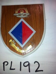
Plaque
Plaque '2/5 field Regiment with colour Patch" Damaged requires repairplaque, army -
 Running Rabbits Military Museum operated by the Upwey Belgrave RSL Sub Branch
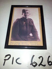
Photo
Photo of John George "Geordie" Johnson 81st Field Regiment Royal Artillery 459 Batteryphoto, army -
 National Vietnam Veterans Museum (NVVM)
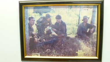
Photograph, Ski, Johnno , Dick, Snow, 1968
Colour photo in Black and Gold Frame.4 Soldiers in field (1 other in background ) Resting /Armed.Coral Belmoral tet 68 Ski Johnno Dick Snow 3 Royal Aust Regiment.battle of coral-balmoral, tet offensive, 1968, 3 rar, photograph -
 National Vietnam Veterans Museum (NVVM)
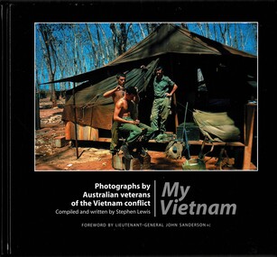
Book, Lewis, Stephen, My Vietnam: Photograph by Australian veterans of the Vietnam conflict. (Copy 1), 2002
My Vietnam is a pictoria journey seen through the cameras of over 80 Australian veterans of the Vietnam conflict.The book is signed by the author. The dustjacket is missing & the hard cover of the book is damaged along the edges & the top of the pages appears water damaged.My Vietnam is a pictoria journey seen through the cameras of over 80 Australian veterans of the Vietnam conflict. 1961-1975 - participation, australian, vietnam war, 1961- 1975 - pictorial works, australian national serviceman, 12th field regiment, royal australian artillery -
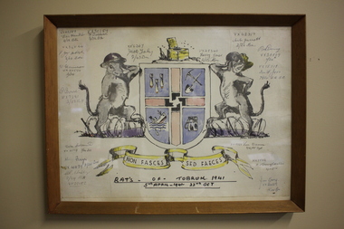 Wangaratta RSL Sub Branch
Work on paper - Coat of Arms, Rats of Tobruk 1941, 1941
Hand drawn Coat of Arms for the soldiers known as the Rats of Tobruk with signatures of those involved in the engagement between 5th April to the 22nd of October 1941 The drawing is signed by artist John DOWIE AM, SX6087 who served with the 2/43rd Battalion Signatories are: VX42389 Eric Hamilton, 2/32 Battalion; VX30189 F.Baldwin, 2/23 Battalion; VX34544, F.J.Mc.Intosh 2/24 Battalion; VX34554 W.Harrison, 2/24 Battalion; WX7281 P.Bone 2/25 Battalion; VX33719 Duke Goldsmith, 2/24 Battalion; VX41179 Harry Frazer, 2/24 Battalion; VX29652 A.R.Stribley, 2/24 Battalion; SX6367 Jack Foley, 2/43 Battalion; VX48340 Harry Jones, 2/23 Battalion; VX42317 Aub Jarrott, 2/24Battalion; VX28869 Rod Deering 2/24Battalion; VX15719 Ian F. Joss 7th Division AASC; VX19723 Len Dauria, 2/12 Field Regiment; NX35852 R.E (Snowy) Cornelius 2/13 Battalion; VX32559 Jim Gray, 2/24Battalion - James Cyril GRAY Born 6/1/1916 in Orroroo South Australia. Enlisted 28/5/1940 at Mildura. Awarded Military Medal for remarkable coolness, bravery and leadership at Tobruk on 24/4 and 1/5/1941. He was promoted to Sergeant on 14/8/1941, Lieutenant in November 1942 then Captain on 9/4/1945. He was wounded in action on 11/9/1943 and discharged on 20/12/1945. He married and had three children. He died on 10/4/1992 aged 76 and buried at Wangaratta Cemetery.This original drawing is by John DOWIE SX6087 who served with the 2/43rd Battalion during the second world war and is signed by the artist and soldiers from the 2/24th Battalion known as "Wangaratta's Own". John Stuart Dowie AM (15 January 1915 – 19 March 2008) was an Australian painter, sculptor and teacher. He was born in the suburb of Prospect in Adelaide, South Australia, and studied architecture at the University of Adelaide. During World War II, Dowie worked in the Military History Unit of the Australian Imperial Force, and as an assistant to Australia's official war sculptor, Lyndon Dadswell. As a soldier, he was one of the Rats of Tobruk. After studying art in London and Florence, Dowie returned to Australia. His work includes over 50 public sculpture commissions, including the "Three Rivers" fountain in Victoria Square, "Alice" in Rymill Park, the "Victor Richardson Gates" at Adelaide Oval and the "Sir Ross & Sir Keith Smith Memorial" at Adelaide Airport. He was made a Member of the Order of Australia in 1981 in recognition of service to the arts as a sculptor and painter. Dowie died on 19 March 2008, aged 93. There is a similiar version of the drawing on page 32 of the book Desert Sand and Jungle Green by Geoffrey Boss-Walker which is an illustrated history of the 2/43rd Battalion.Timber frame containing hand drawn Coat of Arms consisting of "rats" as shield supporters, crest with a swastika in the centre and motto surrounded by signatures.Signatures of artist John Dowie and soldiers engaged at Tobruk. The crest depicts a latrine and the motto reads NON FASCES SED FAECES (Latin translation - "Do not move but the dregs") rats of tobruk, coat of arms, 1941, john dowie -
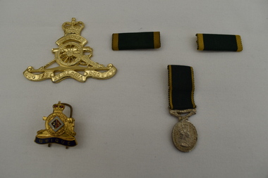 Dandenong/Cranbourne RSL Sub Branch
Souvenir - Badge x 2..Colour Bar x 2. 1 x Efficient Service Medal. (Colour Bars from E S M medals.)
The Efficient Service Medal was instituted in 1930 and awarded to non - commissioned officers and men of the Citizens Military Forces for 12 years of efficient service.2/5 Field Regiment Lapel Badge and Hat Badge Efficient Service Medal Queen Elizabeth 2nd on front - For Efficient Service on rear. -
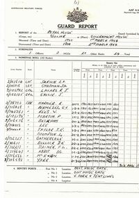 8th/13th Victorian Mounted Rifles Regimental Collection
Document - Royal guard report, AAF A18 Guard Report, 2 March 1954
The 8th/13th Victorian Mounted Rifles was raised as a regiment of the Royal Australian Armoured Corps on 1 May 1948 with Headquarters in Melbourne and squadrons in Sale, Benalla/Wangaratta and Albury. In 1955 Regimental Headquarters moved to Wangaratta and a second squadron was located at Albury. The Sale squadron transferred to 4th/19th Prince of Wales’s Light Horse. In 1977 8/13 VMR Regiment was reduced to an independent squadron A Squadron 8th/13th Victorian Mounted Rifles and in 1991 was linked with 4th/19th Prince of Wales’s Light Horse forming the VMR Squadron of that regiment. The queen was resident at Government House Melbourne for nine days and during the time guard duties were shared by 1st Battalion Royal Australian Regiment, 3rd Division Royal Australian Artillery, 5th Infantry Battalion (Victorian Scottish), 6th Infantry Battalion (Royal Melbourne Regiment), 4th/19th Prince of Wales's Light Horse, 8th/13th Victorian Mounted Rifles, 2nd Medium Regiment, 22nd Field Regiment and Melbourne University Rifles. Rare document relating to guard duty at Government House Melbourne mounted by a unit of the Citizen Military Forces from Victoria during a royal visit .Photocopy of a three page report prepared for period 1/2 March 1954 when 8th/13th Victorian Mounted Rifles Regiment provided the guard at Government House Melbourne during the visit of Her Majesty Queen Elizabeth II. The report lists the officer, 4 non commissioned officers and 20 other ranks comprising the guard together with timings and locations of the sentry posts. Also details of the guard duties, the general remarks at the conclusion of the guard period and the signatures of the Guard Commander, Captain LA Jackson 8th/13th Victorian Mounted Rifles and the Relieving Guard Commander Captain EJ King, 2nd Medium Regiment. queen elizabeth ii, royal visit 1954, government house, melbourne, guard, vmr -
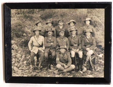 8th/13th Victorian Mounted Rifles Regimental Collection
Photograph - 3rd LH Bde 1918
Following Gallipoli service, 3rd Light Horse Brigade comprising 8th (Victorian), 9th (South Australian/ Victorian) and 10th (West Australian) Light Horse Regiments formed part of the ANZAC Mounted Corps under command of Sir Harry Chauvel in the campaigns through Egypt, Palestine and Syria, 1916-1918. Fine study of senior officers of a Light Horse Brigade in the Middle East during World War 1 (1914-1918).Small Black and white photograph of Brigadier Wilson and Staff, 3rd Light Horse Brigade circa 1918.Back row L-R, Lieutenant Latham, Major Worthington, Captain Lyall, Captain Barker. Front row L-R. Lieutenant - Colonel Stewart ( Field Ambulance ), Lieutenant - Colonel Todd ( 10 Light Horse ), Brigadeer Wilson, ( Brig.( OMD ) , Lieutenant Colonel Wilson ( Brig. OND ), Lieutenant - Colonel Scott ( 9th Light Horse ), Lieutenant - Colonel Daly ( 8th Light Horse ) & seated in front Captain Hammond3rd light horse brigade, wilson, wwi, world war one, middle east -
 8th/13th Victorian Mounted Rifles Regimental Collection
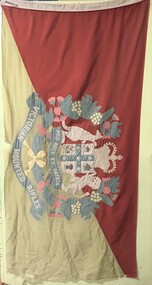
Flag - 8/13 VMR flag
The 8th/13th Victorian Mounted Rifles was raised as a regiment of the Royal Australian Armoured Corps on 1 May 1948 with Headquarters in Melbourne and squadrons in Sale, Benalla/Wangaratta and Albury. In 1955 Regimental Headquarters moved to Wangaratta and a second squadron was located at Albury. The Sale squadron transferred to 4th/19th Prince of Wales’s Light Horse. In 1977 8/13 VMR Regiment was reduced to an independent squadron A Squadron 8th/13th Victorian Mounted Rifles and in 1991 was linked with 4th/19th Prince of Wales’s Light Horse forming the VMR Squadron of that regiment.Coloured flag, red and yellow field divided diagonally with 8/13 Victorian Mounted Rifles crest superimposed at centre.vmr, victorian mounted rifles, flag -
 8th/13th Victorian Mounted Rifles Regimental Collection
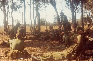
Photograph
Regiments conducted Courses Camps to train RAAC crewmen. The 8th/13th Victorian Mounted Rifles was raised as a regiment of the Royal Australian Armoured Corps on 1 May 1948 with Headquarters in Melbourne and squadrons in Sale, Benalla/Wangaratta and Albury. In 1955 Regimental Headquarters moved to Wangaratta and a second squadron was located at Albury. The Sale squadron transferred to 4th/19th Prince of Wales’s Light Horse. In 1977 8/13 VMR Regiment was reduced to an independent squadron A Squadron 8th/13th Victorian Mounted Rifles and in 1991 was linked with 4th/19th Prince of Wales’s Light Horse forming the VMR Squadron of that regiment.Colour photograph of soldiers resting in bush setting."Assault Troopers Course field debrief conducted by Lt Dan Wyborn ( kneeling ). Lt Tom Goode ( standing ).Puckapunyal Range Courses Camp 1982."assault trooper, wyborn daniel lieutenant, goode tom lieutenant -
 8th/13th Victorian Mounted Rifles Regimental Collection
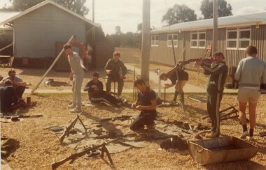
Photograph
Regiments conducted Courses Camps to train RAAC crewmen.The 8th/13th Victorian Mounted Rifles was raised as a regiment of the Royal Australian Armoured Corps on 1 May 1948 with Headquarters in Melbourne and squadrons in Sale, Benalla/Wangaratta and Albury. In 1955 Regimental Headquarters moved to Wangaratta and a second squadron was located at Albury. The Sale squadron transferred to 4th/19th Prince of Wales’s Light Horse. In 1977 8/13 VMR Regiment was reduced to an independent squadron A Squadron 8th/13th Victorian Mounted Rifles and in 1991 was linked with 4th/19th Prince of Wales’s Light Horse forming the VMR Squadron of that regiment.Colour photograph of soldiers on edge of parade ground with weapons." ASLT Troopers Course cleaning weapons after field exercise.Weapons being inspected by CSM ( Green tanksuit ) WO11Len gaughan. Courses Camp Puckapunyal 1982. -
 8th/13th Victorian Mounted Rifles Regimental Collection
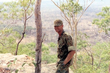
Born digital image, September 1993
The Dibb Report into mainland defence of Australia,1986, among other things identified the requirement for protection of key assets in Northern Australia and the possibility of involving Army Reserve (Ares) units in this thus releasing regular forces for offensive operations. Dibb also pointed out that this defined role would result in a huge lift in Ares morale. In June 1988, the 3rd Division (3Div) conducted a Tactical Exercise without Troops (TEWT), Exercise ‘Distant Trumpet’ in the Katherine- Darwin area to study problems associated with defence against low level incursions against Tindal RAAF Base. Exercise ‘Northern Explorer’ followed in October of that year when units of the 3Div including A Squadron 8/13 Victorian Mounted Rifles sent patrol groups to get a first taste of environment and conditions. Post-Exercise reports had to include recommendations re: health, equipment and adaptation of Standing Operating Procedures (SOPs) in preparation for the new role deploying to Northern Australia. The first deployment by 8/13 Vistorian Mounted Rifles was in 1988. Deployments continued i following years. In September 1993, 3 Troop (Wangaratta) VMR Squadron 4/19 PWLH commanded by Captain Kelvin Robertson deployed to NT. The training began with airfield defence at Tindal followed by a 1000km recon into Arnhem Land in four Landrovers. The troop reported on the conditions of the roads, airfields, bridges (mainly causeways) resources such as fuel supplies in the towns and infrastructure. Each troop taking different route. 3 Troop had the Northern route through Kakadu National park across the East Alligator River to Oenpelli then to Maningrida and Ramangining and south to the Central Arnhem Road and back to Tindal Air force Base. Kelvin Robertson enlisted on 6 April 1981 at Cobram where Lieutenant Dan Wyborn was the troop leader at 2 Troop A Squadron 8th/13th Victorian Mounted Rifles (2TP A SQN 8/13 VMR). He completed the Initial Employment Training Course (IET) and then an M113A1 driver’s course in March 1982. Course Senior Instructor (SI) was Captain (CAPT) John McLean and wing instructor Warrant Officer Class 2 (WO2) Mick Baxter (ex-Driving & Servicing Wing instructor at the School of Armour). He served with 2TP at Cobram as a trooper Driver/Signaller until June 1982 when he was selected for officer training. He served two years as an Officer Cadet in Course 21 at Officer Cadet Training Unit (OCTU) graduating in June 1984. He returned to 8/13 VMR and completed the 1/85 Army Reserve (ARES) Regimental Officers Basic Course (ROBC Reconnaissance), then was posted immediately as 1 TP LDR for the Hay Booligal Annual Field Exercise (AFX). In 1985 he took command of 2TP at Cobram until Nov 1987 when he transferred to C Squadron First Armoured Regiment (CSQN 1AR). This began six months full time duty in which Lieutenant (LT) Robertson completed the regular army 1/88 (ROBC Tank), and then served as CSQN's first and only ARES Leopard Tank TP LDR until the next ARES LT was trained up as 2TP LDR. He later served as the CSQN Liaison Officer (LO) on the First Brigade (1 Bde) exercise ‘Predators Advance’ and as a staff officer on a Second Division (2Div) exercise. In Jan 1991 he studied at the Reserve Command and Staff College (RCSC). Upon completion of Grade 3 he was promoted to CAPT and transferred back to a reconnaissance troop, 3TP VMR SQN 4th/19th Prince of Wales’s Light Horse (4/19PWLH) at Wangaratta. CAPT Robertson transferred to the Inactive List in 1994, but in 2011 returned to the Active List serving as Operations Captain (OPS CAPT) at Regimental Headquarters (RHQ) 12th/16th Hunter River Lancers (12/16 HRL)and later Second-In-Command (2IC) Tamworth-based Operations Support Squadron (OPSPT SQN), and at 9 day exercises at Singleton range and an exercise at Townville High Range in Protective Mobility Vehicle (PMV) Bushmasters. In 2013 after completing the ARES Grade 3 Staff Officers course in Brisbane he returned home to Jerilderie and served as 2IC A SQN 4/19 PWLH based at Latchford Barracks Bonegilla. He was awarded the Defence Long Service Medal (DLSM) in 2014. Highlights of his career included being Parade Commander for the 75th anniversary Beersheba parade in Canberra on 31 October 1992. The guard, drawn from the VMR SQN 4/19 PWLH represented the 4th Light Horse Regiment, a participant of the Charge. Then twenty years later, 2012, he was invited to speak at the Quirindi Anzac Day ceremony. On this occasion he was serving with 12/16 HRL, so in two ceremonies, 20 years apart, he had represented both the 4th LHR and the 12th LHR, the two lead Regiments that charged Beersheba. CAPT Robertson was placed on the Inactive List again in 2015. Illustrates Reserve training in NT.Colour image of soldier with landscape in background being Captain Kelvin Robertson 3 Troop Leader (Wangaratta) VMR Squadron 4th/19th Prince of Wales’s Light Horse Regiment looking out over the Arafura swamp near the Maningrida to Ramingining road in Arnhem Land during exercise in the Northern Territory, September 1993.tindal, robertson -
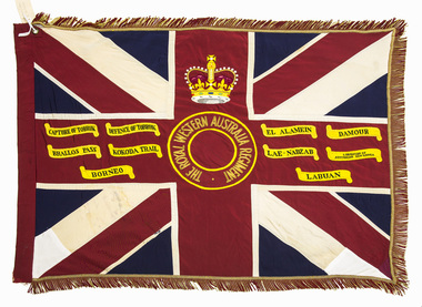 Australian Army Museum of Western Australia
Queen's Colour - 16th Battalion, The Royal Western Australia Regiment
Presented to 1st Battalion, The Royal Western Australia Regiment by Field Marshall HRH The Prince Phillip, Duke of Edinburgh at a parade held at the Western Australian Cricket Association Ground, East Perth on 25 November 1962. The Royal Western Australia Regiment was formed on 1 July 1960 from the amalgamation of all existing infantry battalions in the State at the time :- • 11th/44th Infantry Battalion (The City of Perth Regiment) • 16th Infantry Battalion (The Cameron Highlanders of Western Australia) • 28th Infantry Battalion (The Swan Regiment) At the above presentation of colours to the new battalion, the Colours of the former battalions (four sets of Queen's and Regimental colours) were trooped through the ranks of the battalion and marched off the parade for the last time. These former colours were subsequently laid up in the undercroft at the State War Memorial, King's Park on 29 November 1964. These were transferred to the Army Museum of WA in 1988 as part of the Bicentenary Colours Project. (Refer to Items 4-12 for individual records of these colours) 1st Battalion, The Royal Western Australia Regiment was renumbered 16th Battalion effective from 1st January 1966 as part of a move to reintroduce the old battalion numbers back into the State Regimental system. 16th Battalion, The Royal Western Australia Regiment was presented with a new set of Colours on 27 October 2002. The original 1962 Colours were formally handed over for safe keeping to the Army Museum of Western Australia on 3 November 2002. Battle Honours allocated to the State Infantry Regiments created under the CMF reorganisation in July 1960 were promulgated in Australian Army Order 85/1962. These were a consolidation of the battle honours awarded to the various individual battalions that were amalgamated to form the new regiments. Union flag with gold fringes. In the centre a circle inscribed "THE ROYAL WESTERN AUSTRALIA REGIMENT", surmounted by the Crown. Battle honours emblazoned on the colour : CAPTURE OF TOBRUK, DEFENCE OF TOBRUK, EL ALAMEIN, DAMOUR, BRALLOS PASS, KOKODA TRAIL, LAE-NADZAB, LIBERATION OF AUSTRALIAN NEW GUINEA, BORNEO, LABUAN -
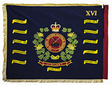 Australian Army Museum of Western Australia
Regimental Colour - 16th Battalion, The Royal Western Australia Regiment
Presented to 1st Battalion, The Royal Western Australia Regiment by Field Marshall HRH The Prince Phillip, Duke of Edinburgh at a parade held at the Western Australian Cricket Association Ground, East Perth on 25 November 1962. The Royal Western Australia Regiment was formed on 1 July 1960 from the amalgamation of the following existing infantry battalions in the State at the time :- • 11th/44th Infantry Battalion (The City of Perth Regiment) • 16th Infantry Battalion (The Cameron Highlanders of Western Australia) • 28th Infantry Battalion (The Swan Regiment) At the above presentation of colours to the new battalion, the Colours of the former battalions (four sets of Queen's and Regimental colours) were trooped through the ranks of the battalion and marched off the parade for the last time. These former colours were subsequently laid up in the undercroft at the State War Memorial, King's Park on 29 November 1964. These were transferred to the Army Museum of WA in 1988 as part of the Bicentenary Colours Project. (Refer to Items 4-12 for individual records of these colours) 1st Battalion, The Royal Western Australia Regiment was renumbered 16th Battalion effective from 1st January 1966 as part of a move to reintroduce the old battalion numbers back into the State Regimental system 16th Battalion, The Royal Western Australia Regiment was presented with a new set of Colours on 27 October 2002. The original 1962 Colours were formally handed over for safe keeping to the Army Museum of Western Australia on 3 November 2002. Battle Honours allocated to the State Infantry Regiments created under the CMF reorganisation in July 1960 were promulgated in Australian Army Order 85/1962. These were a consolidation of the battle honours awarded to the various individual battalions that were amalgamated to form the new regiments. Royal blue with gold and red fringes. In the centre the main device from the regimental badge consisting of a black swan upon a pair of crossed rifles on a red background, within a circle inscribed "THE ROYAL WESTERN AUSTRALIA REGIMENT". The whole enclosed within a wreath of Australian wattle and surmounted by the Crown. Across the lower portion of the wreath a scroll inscribed with the regimental motto "VIGILANT". In the upper canton the Roman numeral "XVI" (Originally this was the numeral "I" - changed to "XVI" in 1966 - see Historical Background details below) Battle honours emblazoned on the colour : SOUTH AFRICA 1899-1902, SOMME 1916-18, POZIERES, BULLECOURT, MESSINES 1917, YPRES 1917, PASSCHENDAELE, AMIENS, MONT ST QUENTIN, HINDENBURG LINE, LANDING AT ANZAC -
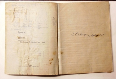 8th/13th Victorian Mounted Rifles Regimental Collection
Book - Field Notebook, Army Book 152 / Correspondence Book / (Field Service), 1916 circa
Field notebook was used by Lieutenant LA Deegan 13th Australian Light Horse Regiment, 1st Anzac Corps Mounted Troops. Book covers the period 20 July 1917 to 1 September 1917.The notebook is well provenanced and is a rare example of the day-to-day correspondence conducted by a regimental officer of a light horse regiment serving on the Western Front in 1917. The contents of the book are of historical significance and were used in "My Corps Cavalry" Doug Hunter, Slouch Hat Publications,1999. Carbon copies are legible and the general condition of the object is good considering its age.Natural coloured soft cover bound carbon copy duplicate book. Book has been used for routine correspondence and reports.deegan leslie lieutenant, 13th light horse, field notebook -
 8th/13th Victorian Mounted Rifles Regimental Collection
Photograph
Shows field dress and webbing equipment worn in 1989. The 8th/13th Victorian Mounted Rifles was raised as a regiment of the Royal Australian Armoured Corps on 1 May 1948 with Headquarters in Melbourne and squadrons in Sale, Benalla/Wangaratta and Albury. In 1955 Regimental Headquarters moved to Wangaratta and a second squadron was located at Albury. The Sale squadron transferred to 4th/19th Prince of Wales’s Light Horse. In 1977 8/13 VMR Regiment was reduced to an independent squadron A Squadron 8th/13th Victorian Mounted Rifles and in 1991 was linked with 4th/19th Prince of Wales’s Light Horse forming the VMR Squadron of that regiment.Black and white photograph of two soldiers of 8/13 Victorian Mounted Rifles cleaning the barrel of a 76mm gun on 76mm M113 Fire Support Vehicle. Corporal Marcos Ludeman at left. -
 The 5th/6th Battalion Royal Victoria Regiment Historical Collection
Booklet - Book, Field Service Regulations Vol 1 1930, 1930
Small Pam with red cover, title written in black on spine. some fading and water damage on cover. Book has 423 pages.wark vc club, inter war -
 Melbourne Legacy
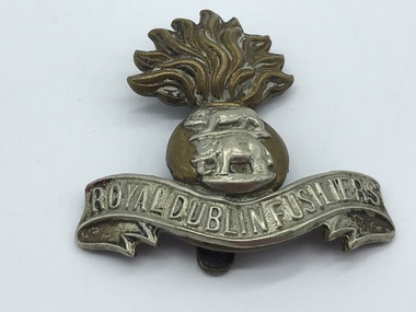
Badge, Royal Dublin Fusiliers Regiment cap badge
A badge that once belonged to J B McLean, he could have brought it back from World War as a souvenir. From information found online: 'The Royal Dublin Fusiliers was an infantry regiment of the British Army, which recruited in the east of Ireland. Created in 1881 by the amalgamation of two former East India Company regiments, it was disbanded in 1922 on the establishment of the Irish Free State.' These were with other World War 1 memorabilia that has come from Private John Basil McLean, 2nd Reinforcements, 37th Battalion, A.I.F. J.B. McLean (Service No. 13824) was from near Maffra, Victoria and enlisted on 22 January 1916. He embarked on 16 December 1916 for Europe. He spent time with the Australian Field Artillery (Pack Section). At the end of the war he worked for a year at the A.I.F. Headquarters in London before returning to Australia on the 'Ceramic', arriving in Portsea in 1920. His full war record is available from the National Archives of Australia (B2455, MCLEAN JBM).This is an example of souvenir retained by an ex soldier.Royal Dublin Fusiliers Regiment cap badge. It is a bi-metal badge in the form of a fused (or flaming) grenade, on the brass ball of which is a white metal Royal Tiger above an elephant (both in white metal). At the base a white metal scroll bearing the title 'ROYAL DUBLIN FUSILIERS'. Royal Dublin Fusiliers world war one, soldier -
 Melbourne Legacy
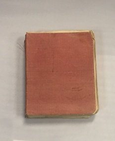
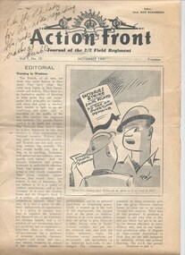
Journal, Action Front. Journal of the 2/2 Field Regiment, 1941
An issue of 'Action Front. Journal of the 2/2 Field Regiment' for the soldiers. This edition is Vol 1 Issue No. 10 April 1919. Comprised of stories, poems, drawings, records of military awards. Printed by M. Shoham's Press, Tel-Aviv. An item from Legatee Frank Doolan, who was on the archive committee and made attempts to collate the history of Legacy. A record of publications made for the troops in World War 2.A copy of 'Action Front. Journal of the 2/2 Field Regiment' a field newspaper published for the troops in World War 2 x 12 pages.Hand written on the front 'Ask the old lady for the notes regarding the rude cracks at their CO'world war two, short stories, poem -
 Melbourne Legacy
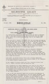
Article, Bulletin VALE Legatee John Ernest Cooper
An article from the Melbourne Legacy Bulletin on the death of Legatee John Cooper (President of Melbourne Legacy in 1968). The article is a reprint of Legatee Kemsley oration at the funeral on 2 April 1980 at St Andrew's Anglican Church Brighton. The Bulletin published articles on Legatees when they passed away. Legatee John Cooper, born in 1919 and died in 1980. During his war service he served in 2/4th Field Regiment with 7th Division in PNG and Borneo, gaining the rank of Lieutenant. He joined Legacy in 1951 after being nominated by Legatee Dudley Gallagher. The article was part of an album of past presidents from 1965 to 1989. The folder included biographical details and obituaries, eulogies and death notices of prominent Legatees. The items have been catalogued separately.A record of Legatee John Cooper a past president of Legacy. The information was collected to record the lives of prominent legatees in a folder.Typed copy of a page from the Legacy Bulletin on the death of Legatee John Cooper - President 1968Bulletin No 2481. 8.4.1980. Page No 1 and 2past presidents, vale, john cooper -
 Melbourne Legacy
Photograph - Portrait, Legatee Arthur H Smith, 194
A portrait of Legatee Arthur Henson Smith who was a legatee that had rejoined to serve in the second World War. His ribbon bar indicates he had served in the first World War. His Vale notice that appeared in the Bulletin on 22 January 1973 says he had landed at Gallipoli on 25 April 1915. He went on to serve with the 2nd Brigade AFA and the 3rd Army Brigade Artillery. On 1 May 1940 he enlisted with the 2/9 Field Regiment of the 2nd AIF with the rank of Lieutenant-Colonel and served in Syria and the Middle East. Arthur Smith was inducted into Legacy in 1935 and served on many committees, until he reluctantly was put on reserve list in 1965 due to illness. He died in 1973. The portrait was in an album of photos taken in the 1940s (mostly 1945). A record of a legatee enlisting to serve in the second World War.Black and white portrait of Arthur H Smith, who was a legatee who re-enlisted in WW2. Part of a photo album with blue leather look back and front cover. From one of 20 pages with black and white photos. Legatee Arthur Henson Smith fought at Gallipoli, he ended WW1 as a Captain and finished WW1 as a Lieutenant Colonel. He died on 19 January 1973.legatee, portrait, arthur smith, vale -
 Bendigo Military Museum
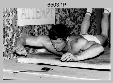
Photograph - 4th Field Survey Squadron – CPL John Ratcliffe World Record, Keswick Barracks, Adelaide SA, 1986
This is a set of 12 photographs of 4th Field Survey Squadron’s CPL John Ratcliffe setting a world record for an exercise routine comprising push-ups, sit-ups and double back-arches at Keswick Barracks, Adelaide in November 1986. A newspaper article of unknown origin titled “John sets world’s best time in routine” was published reporting the achievement. The article reported: “Corporal John Ratcliffe has smashed his personal best time, his greatest expectations and the 16-year-old Australian record for a push-up, sit-up and double back-arch routine. Corporal Ratcliffe, 37, set a world record by doing 1232 push-ups (clapping his chest with his hands between each one), 1936 back-arches and 440 sit-ups in one hour, 16 minutes and 29 seconds yesterday. Officials representing the Guinness Book of Records were present and passed his effort. The record was achieved by repeating a set of 14 push-ups, 22 double back-arches and 5 sit-ups, 88 times. The Australian record for the same routine was set in 1970 in the time of 1 hour 41 minutes. CPL Ratcliffe beat his personal best time by 13 minutes. “I could not do it without them” CPL Ratcliffe said of the crowd. Nearing the end of the routine when he was tiring, the crowd of more than 100 clapped and chanted encouragement. CPL Ratcliffe, who works in the Army’s surveying department, said the most important aspect of the exercise was raising money for Legacy, not getting his name in the record books.” This achievement was also reported in the Army Newspaper dated 11th Dec 1986. There are eight more photos that have not been published in the set of negatives.This is a set of 12 photographs of 4th Field Survey Squadron’s CPL John Ratcliffe setting a exercise routine world record at Keswick Barracks, Adelaide in November 1986. The black & white photographs are on 35mm negative film and are part of the Army Survey Regiment’s Collection. The photographs were scanned at 96 dpi. .1) to .9) - Photo, black & white, 1986. CPL John Ratcliffe during his exercise routine. .10) - Photo, black & white, 1986. CPL John Ratcliffe celebrates the new world record. L to R: Bob Rogister, Wally Chilcott. .11) - Photo, black & white, 1986. CPL John Ratcliffe celebrates the new world record. L to R: Peter Imeson, Bob Rogister, Wally Chilcott. .12) - Photo, black & white, 1986. CPL John Ratcliffe interviewed by media after setting the new world record. .1P to .12P – There are no other personnel identified. ‘CPL RATCLIFFE “WORLD RECORD”. NOV 1986’ annotated on negatives sleeve.royal australian survey corps, rasvy, 4 fd svy sqn -
 Bendigo Military Museum
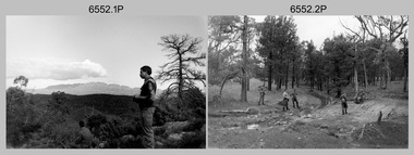
Photograph - 4th Field Survey Squadron Adventurous Training, Wilpena pound, Flinders Ranges, SA, 1989
This is a set of 43 photographs of a 4th Field Survey Squadron adventurous training held at Wilpena pound, in the Flinders Ranges of South Australia in 1989. It is evident the training focussed on teamwork, leadership, abseiling, rock climbing, field craft and living off the land survival skills. Elements from units of the Army Reserve also participated in the training. In this photo set, one of 4th Field Survey’s sections participated in abseiling and trekked to the highest mountain in the Flinders Ranges – St. Mary’s Peak. Refer to items 6553.56P for additional colour photographs taken during the adventurous training exercise.This is a set of 43 photographs of 4th Field Survey Squadron personnel undergoing adventurous training held at Wilpena pound, in the Flinders Ranges of South Australia in 1989. The black & white photographs are on 35mm negative film and are part of the Army Survey Regiment’s Collection. The photographs were scanned at 96 dpi. .1) - Photo, black & white, 1989. L to R: SGT Laurie Justin, SGT Stu Symonds. .2) - Photo, black & white, 1989. L to R: SGT Stu Symonds, CPL Roger Graf, SSGT Max Coletti, SPR Cheryl Deluca-Cardillo, SPR Andrew Quin. .3) & .4) - Photo, black & white, 1989. Wilpena Pound topography. .5) - Photo, black & white, 1989. SGT Stu Symonds. .6) - Photo, black & white, 1989. Abseiling ropes and equipment. .7) to .16) - Photo, black & white, 1989. Abseiling activities, unidentified soldier. .17) to .18) - Photo, black & white, 1989. Abseiling activities, CPL Michelle Griffith. .19) - Photo, black & white, 1989. L to R: unidentified (x5), SGT Mick Hogan, unidentified (x3). .20) - Photo, black & white, 1989. L to R: CPL Roger Graf, CPL Michelle Griffith, SPR Cheryl Deluca-Cardillo, SGT Laurie Justin, SSGT Max Coletti, SPR Andrew Quin. SGT Stu Symonds. .21) - Photo, black & white, 1989. L to R: unidentified (x2), SGT Stu Symonds. .22) & .23) - Photo, black & white, 1989. Wilpena Pound topography. .24) - Photo, black & white, 1989. SSGT Max Coletti. .25) - Photo, black & white, 1989. SSGT Max Coletti, SPR Cheryl Deluca-Cardillo, SGT Stu Symonds. .26) - Photo, black & white, 1989. SGT Stu Symonds. .27) - Photo, black & white, 1989. L to R: CPL Michelle Griffith, SPR Cheryl Deluca-Cardillo, SSGT Max Coletti, SGT Laurie Justin, SPR Andrew Quin, CPL Roger Graf, SGT Stu Symonds. .28) &.29) - Photo, black & white, 1989. Wilpena Pound topography. .30) - Photo, black & white, 1989. SGT Stu Symonds. .31) - Photo, black & white, 1989. CPL Michelle Griffith. .32) - Photo, black & white, 1989. L to R: CPL Michelle Griffith, SGT Stu Symonds, SSGT Max Coletti, SGT Laurie Justin. .33) - Photo, black & white, 1989. L to R: CPL Michelle Griffith, SGT Stu Symonds, CPL Roger Graf (standing), SSGT Max Coletti, SGT Laurie Justin. .34) - Photo, black & white, 1989. L to R: SGT Stu Symonds, CPL Michelle Griffith, CPL Roger Graf (standing), SSGT Max Coletti, SGT Laurie Justin. .35) to .37) - Photo, black & white, 1989. Wilpena Pound topography. .38) - Photo, black & white, 1989. SPR Cheryl Deluca-Cardillo. .39) - Photo, black & white, 1989. L to R: CPL Michelle Griffith, SGT Stu Symonds, SPR Andrew Quin, SGT Laurie Justin. .40) &.41) - Photo, black & white, 1989. Wilpena Pound topography. .1P to .43P – There are no personnel identified. ‘1989 ADV TRAINING’ annotated on negatives sleeve.royal australian survey corps, rasvy, 4 fd svy sqn -
 Bendigo Military Museum
Photograph - 4th Field Survey Squadron Adventurous Training, Wilpena pound, Flinders Ranges, SA, 1989
This is a set of 55 photographs of a 4th Field Survey Squadron adventurous training held at Wilpena pound, in the Flinders Ranges of South Australia in 1989. It is evident the training focussed on teamwork, leadership, abseiling, rock climbing, field craft and living off the land survival skills. Elements from units of the Army Reserve also participated in the training. In this photo set, one of 4th Field Survey’s sections participated in abseiling and trekked to the highest mountain in the Flinders Ranges – St. Mary’s Peak. Refer to item 6552.43P for black & white photographs taken during the adventurous training exercise.This is a set of 55 photographs of 4th Field Survey Squadron personnel undergoing adventurous training held at Wilpena pound, in the Flinders Ranges of South Australia in 1989. The colour photographs are on 35mm negative film and are part of the Army Survey Regiment’s Collection. The photographs were scanned at 96 dpi. .1) & 2)- Photo, colour, 1989. Base camp. WO1 Bill Griggs 2nd from left, remainder unidentified. .3) - Photo, colour, 1989. Old homestead inside Wilpena Pound. SPR Cheryl Deluca-Cardillo, 2nd from left, remainder unidentified. .4) - Photo, colour, 1989. Wilpena Pound topography. .5) - Photo, colour, 1989. Abseiling activities, unidentified personnel. .6) & .7) - Photo, colour, 1989. Flinders Ranges topography. .8) - Photo, colour, 1989. Abseiling activities. L to R: SSGT Max Coletti, SGT Stu Symonds. .9) - Photo, colour, 1989. Abseiling activities, unidentified personnel. .10) - Photo, colour, 1989. Flinders Ranges topography. .11) - Photo, colour, 1989. Abseiling activities. L to R: unidentified, CPL Michelle Griffith, SGT Stu Symonds. .12) - Photo, colour, 1989. Abseiling activities. L to R: unidentified, SPR Andrew Quin, SGT Laurie Justin, SGT Stu Symonds. .13) - Photo, colour, 1989. Abseiling activities. L to R: SGT Stu Symonds SGT Laurie Justin. .14) - Photo, colour, 1989. Abseiling activities. L to R: unidentified, SGT Stu Symonds. .15) - Photo, colour, 1989. Abseiling activities. SGT Laurie Justin. .16) - Photo, colour, 1989. Abseiling activities. SGT Stu Symonds. .17) & .18) - Photo, colour, 1989. Abseiling activities. SPR Cheryl Deluca-Cardillo. .19) - Photo, colour, 1989. Abseiling activities. L to R: SPR Cheryl Deluca-Cardillo, unidentified. .20) - Photo, colour, 1989. Abseiling activities. SSGT Max Coletti. .21) - Photo, colour, 1989. Abseiling activities. SPR Andrew Quin. .22) - Photo, colour, 1989. Abseiling activities. CPL Michelle Griffith. .23) - Photo, colour, 1989. Abseiling activities. CPL Michelle Griffith. .24) - Photo, colour, 1989. Flinders Ranges topography, unidentified personnel. .25) - Photo, colour, 1989. Flinders Ranges topography, unidentified SGT. .26) to .30) - Photo, colour, 1989. Flinders Ranges topography. .31) - Photo, colour, 1989. Flinders Ranges topography, unidentified personnel. .32) & .33) - Photo, colour, 1989. Flinders Ranges topography. L to R: unidentified, CPL Michelle Griffith, SGT Stu Symonds, CPL Roger Graf, SSGT Max Coletti, SGT Laurie Justin. .34) - Photo, colour, 1989. St. Mary’s Peak. L to R: unidentified, CPL Michelle Griffith, CPL Steve Nokes, SGT Stu Symonds. .35) - Photo, colour, 1989. St. Mary’s Peak. SGT Stu Symonds. .36) & .37) - Photo, colour, 1989. St. Mary’s Peak. CPL Steve Nokes. .38) - Photo, colour, 1989. Flinders Ranges topography. .39) - Photo, colour, 1989. St. Mary’s Peak. SGT Laurie Justin. .40) - Photo, colour, 1989. St. Mary’s Peak. SPR Cheryl Deluca-Cardillo. .41) - Photo, colour, 1989. St. Mary’s Peak. SPR Andrew Quin. .42) - Photo, colour, 1989. Flinders Ranges topography, SGT Stu Symonds. .43) - Photo, colour, 1989. Social activities. L to R: unidentified (x6), CPL Perry Langeberg, SGT Laurie Justin. .44) - Photo, colour, 1989. Social activities. L to R: CPL Perry Langeberg, SGT John Zuringer, SGT Laurie Justin, SGT Mick Hogan, unidentified, SGT Stu Symonds. .45) - Photo, colour, 1989. Social activities. L to R: unidentified (x6), CPL Perry Langeberg, SGT John Zuringer. .46) - Photo, colour, 1989. Social activities. L to R: CPL Jamie McRae, SGT Laurie Justin, SGT Mick Hogan, unidentified, SGT Stu Symonds, SPR Cheryl Deluca-Cardillo, WO1 Bill Griggs. .47) - Photo, colour, 1989. Social activities. L to R: SGT Laurie Justin, unidentified, CPL Steve Nokes, SGT Stu Symonds, SPR Cheryl Deluca-Cardillo, WO1 Bill Griggs, unidentified (x2). .48) - Photo, colour, 1989. Social activities. L to R: CPL Steve Nokes, WO1 Bill Griggs, SPR Cheryl Deluca-Cardillo, unidentified (x2), CPL Steve Ellis, CPL Michelle Griffith, SGT Gill Park. .49) - Photo, colour, 1989. Social activities. L to R: CPL Perry Langeberg, SGT John Zuringer, CPL Jamie McRae, SGT Laurie Justin, SGT Mick Hogan, unidentified, SGT Stu Symonds. .50) - Photo, colour, 1989. Sheep cooking in fire pit. L to R: WO2 Peter Symmans, unidentified (x5), CPL Steve Ellis. .51) - Photo, colour, 1989. Sheep cooking in fire pit. L to R: WO2 Peter Symmans, unidentified. .52) - Photo, colour, 1989. Sheep cooking in fire pit. Unidentified personnel. .53) - Photo, colour, 1989. Cooked sheep removed from fire pit. L to R: unidentified. WO2 Peter Symmans, unidentified. .54) - Photo, colour, 1989. Cooked sheep removed from fire pit. L to R: CPL Michelle Griffith, SGT Gill Park, unidentified, SSGT Max Coletti, unidentified, SPR Cheryl Deluca-Cardillo. .55) - Photo, colour, 1989. Cooked sheep removed from fire pit. L to R: unidentified, CPL Michelle Griffith, WO2 Peter Symmans..1P to .55P – There are no personnel identified. ‘1989 ADV TRAINING’ annotated on negatives sleeve.royal australian survey corps, rasvy, 4 fd svy sqn -
 Bendigo Military Museum
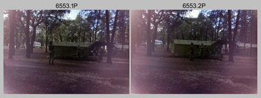
Photograph - 4th Field Survey Squadron deployed on Operation NERIGHT, Queensland & Northern Territory, 1989
This is a set of 19 photographs taken in 1989 during 4th Field Survey Squadron’s deployment on Operation NERIGHT 89 in Queensland and the Northern Territory. It was a two-part operation in 1989 with work conducted in the areas of Camooweal and Weipa. Part 1 was the field completion of topographic maps conducted near Camooweal QLD, along the Barkley Highway on the border between NT and QLD, from the 12th of September to the 20th of October 1989. A Bell Kiowa LOH helicopter from 162 Recce Sqn supported topographic field completion. Operation NERIGHT 89 Part 2 was the acquisition of mapping control by GPS field parties utilising Texas Instruments TI4100 Global Positioning System receivers around Weipa on Cape York Peninsula from the 22nd of September to the 22nd of October 1989. Part 2 Two Bell UH-1H Iroquois helicopters from RAAF’s 35 Squadron were principally used to deploy GPS field parties. Identification photography of control points was taken by air camera operators in AAAvn Pilatus Porter aircraft from 173 Gen Spt Sqn fitted with an RC10 aerial camera. The two parts of the operation were conducted concurrently. This is a set of 19 photographs taken in 1989 during 4th Field Survey Squadron’s deployment on Operation Neright in Queensland & the Northern Territory. The colour photographs are on 35mm negative film and are part of the Army Survey Regiment’s Collection. The photographs were scanned at 96 dpi. .1) to .3) - Photo, colour, 1989. En-route to areas of survey operations. .4) to .5) - Photo, colour, 1989. Unidentified personnel relax next to river/waterhole. .6) - Photo, colour, 1989. Two Bell UH-1H Iroquois helicopters from RAAF’s 35 SQN utilised in the movement of GPS parties. .7) to .9) - Photo, colour, 1989. Unidentified soldier practices repelling from a UH1H Iroquois helicopter. .10) - Photo, colour, 1989. Inside the cockpit of a UH1H Iroquois helicopter. .11) - Photo, colour, 1989. Field Party camp with GPS equipment in foreground. Unidentified soldier prepares a meal. .12) - Photo, colour, 1989. GPS antenna plumbed over a survey ground mark. Witness post on left. .13) & .14) - Photo, colour, 1989. Unknown Cape York Peninsula beaches. .15) & .16) - Photo, colour, 1989. Dramatic fire next to base camp. .17) - Photo, colour, 1989. Aboriginal rock art at unknown location. .18) - Photo, colour, 1989. Aboriginal rock art at unknown location. L to R: unidentified, SPR Andrew Quin. .19) - Photo, colour, 1989. Aboriginal rock art at unknown location. LT Chris Topovsek..1P to .19P – There are no personnel identified. ‘1989 OP NERIGHT’ annotated on negative sleeve.royal australian survey corps, rasvy, 4 fd svy sqn, op neright 89 -
 Bendigo Military Museum
Photograph - 4th Field Survey Squadron 75thAnniversary Corps Day Formal Dinner, Keswick Barracks, Adelaide SA, 1990
This is a set of 14 photographs of a 4th Field Survey Squadron Officers, Warrant Officers and Sergeants Formal Dinner held at Keswick Barracks, Adelaide SA in 1990. This formal dinner was held to commemorate the 75th anniversary of the formation of the Royal Australian Survey Corps. It is apparent there were visiting personnel from the Army Survey Regiment and other unidentified units. See item 6556.8P for photos taken at 4th Field Survey Squadron commemorating the 75th anniversary.This is a set of 14 photographs of a 4th Field Survey Squadron Officer, Warrant Officer and Sergeant’s Formal Dinner held at Keswick Barracks, Adelaide SA in 1990. The colour photographs are on 35mm negative film and are part of the Army Survey Regiment’s Collection. The photographs were scanned at 96 dpi. .1) - Photo, colour, 1990. L to R: SSM WO1 Alan Toogood - Dining President, SGT Peter Hardy – Mr Vice. .2) - Photo, colour, 1990. Guest Arrival. L to R: unidentified officers (x2), unidentified guests (x2), SGT Peter Hardy – Mr Vice, unidentified guest. .3) - Photo, colour, 1990. Guest Arrival. L to R: unidentified guest, unidentified SNCO & senior officer, unidentified guests (x3), SGT Peter Hardy – Mr Vice. .4) - Photo, colour, 1990. Guest Arrival. L to R: unidentified guest, LTCOL George Ricketts (Ret), SSM WO1 Alan Toogood - Dining President, SGT Peter Hardy – Mr Vice. .5) - Photo, colour, 1990. Guest Arrival. L to R: LTCOL Rene van den Tol - CO Army Svy Regt, unidentified guest, SGT Peter Hardy – Mr Vice. .6) - Photo, colour, 1990. Guest Arrival. L to R: SGT Peter Hardy – Mr Vice, probably the RSM of Keswick Barracks. .7) - Photo, colour, 1990. Guest Arrival. SGT Jamie McRae and partner. .8) - Photo, colour, 1990. Guest Arrival. SGT John Zuringer and partner. .9) - Photo, colour, 1990. Head table facing camera L to R: unidentified guest, LTCOL George Ricketts (Ret), unidentified guest, SSM WO1 Alan Toogood - Dining President. Unidentified officer & guests in foreground. .10) - Photo, colour, 1990. Head table facing camera L to R: LTCOL George Ricketts (Ret), unidentified guest, SSM WO1 Alan Toogood - Dining President, OC MAJ Laurie Newton, unidentified officer & guests. Unidentified guests in foreground. .11) - Photo, colour, 1990. Facing camera right of candlesticks L to R: CAPT Danny Galbraith, unidentified guest, SGT Stu Symonds, Tracey Phillips, SGT John Zuringer. .12) - Photo, colour, 1990. Facing camera L to R: WO1 Bill Griggs, unidentified guest, SGT Steve Winner, unidentified guest, SSGT Peter Hammer, unidentified guest, LTCOL Rene van den Tol - CO Army Svy Regt, unidentified guest, SGT John Phillips. Remainder unidentified. .13) - Photo, colour, 1990. Facing camera L to R: unidentified guest, SGT Jamie McRae, unidentified guest, SGT Peter Hardy – Mr Vice. Remainder unidentified. .14) - Photo, colour, 1990. Facing camera L to R: unidentified guests, Mr Darby Munro (behind candlestick), unidentified guest, SGT Eddie Jacobs, unidentified senior officer, unidentified guest, CAPT Tony Stephens. Remainder unidentified. .1P to .14P – There are no personnel identified. ‘1990 CORPS BIRTHDAY’ annotated on negatives sleeve.royal australian survey corps, rasvy, 4 fd svy sqn -
 Bendigo Military Museum
Photograph - 4th Field Survey Squadron 75thAnniversary Corps Day Formal Dinner, Keswick Barracks, Adelaide SA, 1990
This is a set of eight photographs of a 4th Field Survey Squadron Function held at Keswick Barracks, Adelaide SA in 1990. This function was held to commemorate the 75th anniversary of the formation of the Royal Australian Survey Corps. See item 6555.14P for photos taken at a Formal Dinner commemorating the 75th anniversary.This is a set of eight photographs of a 4th Field Survey Squadron 75thAnniversary Corps Day function held at Keswick Barracks, Adelaide SA in 1990. The colour photographs are on 35mm negative film and are part of the Army Survey Regiment’s Collection. The photographs were scanned at 96 dpi. .1) - Photo, colour, 1990. Cake commemorating the of the formation of the Royal Australian Survey Corps. .2) - Photo, colour, 1990. Cutting the 75th anniversary Cake L to R: SPR Doug Willis, OC MAJ Laurie Newton. .3) - Photo, colour, 1990. Cutting the 75th anniversary Cake L to R: OC MAJ Laurie Newton, SPR Doug Willis. .4) & .5) - Photo, colour, 1990. Cutting the 75th anniversary Cake. OC MAJ Laurie Newton with unidentified guests and children. .6) - Photo, colour, 1990. 75th anniversary celebrations L to R: SGT Mal Paterson, WO1 Stevo Hinic, unidentified children. .7) - Photo, colour, 1990. Unauthorised driver attempting to take a Unimog truck for a spin.. .8) - Photo, colour, 1990. SGT John Ratcliffe working on a map overlay..1P to .8P – There are no personnel identified. ‘1990 CORPS BIRTHDAY’ annotated on negatives sleeve.royal australian survey corps, rasvy, 4 fd svy sqn -
 Bendigo Military Museum
Photograph - 4th Field Survey Squadron Adventurous Training, Unknown Location, SA, 1990
This is a set of seven photographs of 4th Field Survey Squadron undergoing adventurous training held at an unknown location in South Australia, in 1990. It is probable the training focussed on teamwork, leadership, field craft and living off the land survival skills. Elements from units of the Army Reserve may have participated in the training. This is a set of seven photographs of 4th Field Survey Squadron personnel undergoing adventurous training held at an unknown location in South Australia in 1990. The colour photographs are on 35mm negative film and are part of the Army Survey Regiment’s Collection. The photographs were scanned at 96 dpi. .1) - Photo, colour, 1990. Unidentified personnel. .2) & .3) - Photo, colour, 1990. L to R: unidentified, SGT John Zuringer, unidentified. .4) - Photo, colour, 1990. L to R: SPR Pat Austine, unidentified. .5) - Photo, colour, 1990. SPR Doug Willis. .6) - Photo, colour, 1990. L to R: SPR Pat Austine, SPR Doug Willis. .7) - Photo, colour, 1990. L to R: unidentified (x2), SPR Pat Austine, SGT John Zuringer, unidentified (x2)..1P to .7P – There are no personnel identified. ‘1990 ADV TRAINING’ annotated on negatives sleeve.royal australian survey corps, rasvy, 4 fd svy sqn