Showing 108 items matching "bay street brighton"
-
 Bayside Gallery - Bayside City Council Art & Heritage Collection
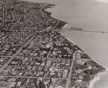
Photograph - gelatin silver photograph, Shaw-Ross Aviation Company, Airspy, Middle Brighton, 1935
... Road St Kilda Street Brighton Beach Port Phillip Bay Gelatin ...brighton, middle brighton, aerial, photograph, airspy, shaw-ross aviation company, suburbs, sea baths, pier, dudley street, st ninian's road, st kilda street, brighton beach, port phillip bay -
 Bayside Gallery - Bayside City Council Art & Heritage Collection
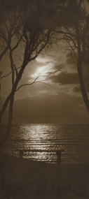
Photograph - sepia photograph, H. Singer, Sunset Brighton Beach, 1919
brighton, beach, sunset, h. singer, photograph, port phillip bay, ti-tree -
 Bayside Gallery - Bayside City Council Art & Heritage Collection
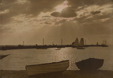
Photograph - sepia photograph, Middle Brighton Pier
brighton, pier, middle brighton pier, boats, port phillip bay, beach -
 Bayside Gallery - Bayside City Council Art & Heritage Collection
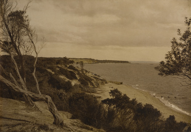
Photograph - sepia photograph, Sandringham
sandringham, beach, coast, red bluff, port phillip bay, ti-tree -
 Bayside Gallery - Bayside City Council Art & Heritage Collection
Photograph, Department of Crown Lands and Survey, Victoria, Melbourne Project: Brighton and Elwood, 1976
The Department of Crown Lands and Survey (1857-1983) was responsible for the administration of survey and mapping and the sale, occupation and management of crown land throughout its existence. This aerial photograph shows parts of Brighton and Elwood and was taken on 1 December 1976brighton, elwood, department of crown lands and survey, aerial photograph, elsternwick park, point ormond, north road, ormond esplanade, st kilda street, glen huntly road, bayside, port phillip bay, map, cartographic material, melbourne project 1976 -
 Bayside Gallery - Bayside City Council Art & Heritage Collection
Photograph, Department of Crown Lands and Survey, Victoria, Melbourne Project: Brighton, Hampton, Sandringham, 1976
The Department of Crown Lands and Survey (1857-1983) was responsible for the administration of survey and mapping and the sale, occupation and management of crown land throughout its existence. This aerial photograph shows parts of Brighton, Hampton and Sandringham and was taken on 1 December 1976brighton, department of crown lands and survey, aerial photograph, bayside, port phillip bay, map, cartographic material, hampton, sandringham, green point, sandringham yacht club, south road, beach road, hampton street, melbourne project 1976 -
 Bayside Gallery - Bayside City Council Art & Heritage Collection
Photograph, Department of Crown Lands and Survey, Victoria, Melbourne Project: Brighton, 1976
The Department of Crown Lands and Survey (1857-1983) was responsible for the administration of survey and mapping and the sale, occupation and management of crown land throughout its existence. This aerial photograph shows parts of Brighton and was taken on 1 December 1976brighton, department of crown lands and survey, aerial photograph, bayside, port phillip bay, map, cartographic material, melbourne project 1976, brighton yacht club, middle brighton baths, north road, st kilda street, new street -
 Bayside Gallery - Bayside City Council Art & Heritage Collection
Photograph, Department of Crown Lands and Survey, Victoria, Melbourne Project: Brighton and Hampton, 1976
The Department of Crown Lands and Survey (1857-1983) was responsible for the administration of survey and mapping and the sale, occupation and management of crown land throughout its existence. This aerial photograph shows parts of Brighton and Hampton and was taken on 1 December 1976. brighton, department of crown lands and survey, aerial photograph, bayside, port phillip bay, map, cartographic material, melbourne project 1976, brighton yacht club, middle brighton baths, hampton, green point, brighton beach, south road, the esplanade, hampton street -
 Bayside Gallery - Bayside City Council Art & Heritage Collection
Photograph, Department of Crown Lands and Survey, Victoria, Brighton, Elwood and Elsternwick, c. 1965-71
The Department of Crown Lands and Survey (1857-1983) was responsible for the administration of survey and mapping and the sale, occupation and management of crown land throughout its existence. This aerial photograph shows parts of Brighton, Elwood and Elsternwick and was taken circa 1965-71.brighton, department of crown lands and survey, aerial photograph, bayside, port phillip bay, map, cartographic material, elwood, elsternwick, elsternwick park, elwood tram depot, elwood pier, new street, glen huntly road, st kilda street, nepean highway -
 Bayside Gallery - Bayside City Council Art & Heritage Collection
Photograph, Department of Crown Lands and Survey, Victoria, Brighton, Brighton East and Bentleigh, c. 1965-71
The Department of Crown Lands and Survey (1857-1983) was responsible for the administration of survey and mapping and the sale, occupation and management of crown land throughout its existence. This aerial photograph shows parts of Brighton, Brighton East and Bentleigh and was taken circa 1965-71.brighton, department of crown lands and survey, aerial photograph, bayside, port phillip bay, map, cartographic material, bentleigh, brighton east, dendy park, dendy street, centre road, nepean highway, south road, football -
 Bayside Gallery - Bayside City Council Art & Heritage Collection
Photograph, Department of Crown Lands and Survey, Victoria, Brighton, Brighton East and Bentleigh, c. 1965-71
The Department of Crown Lands and Survey (1857-1983) was responsible for the administration of survey and mapping and the sale, occupation and management of crown land throughout its existence. This aerial photograph shows parts of Brighton and Brighton East and was taken circa 1965-71.brighton, department of crown lands and survey, aerial photograph, bayside, port phillip bay, map, cartographic material, brighton east, dendy park, dendy street, centre road, nepean highway, south road, brighton golf course, golf -
 Bayside Gallery - Bayside City Council Art & Heritage Collection
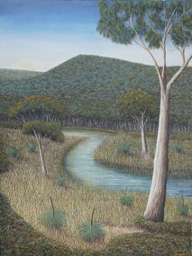
Painting - oil and acrylic on canvas, Robert Kelly, Chinaman's Creek, 2016
Bob Kelly paints landscapes of culturally significant sites along the Mornington Peninsula and depicts these locations as he imagines they originally were before colonisation. Using traditional Western painting techniques, Kelly records the underlying spirit of the Peninsula from a Wathaurong perspective. Chinaman’s Creek in Capel Sound (Rosebud West) was an important watercourse that originally ran from Wonga (Arthur’s Seat) down through Tootgarook Swamp into Port Phillip Bay. It was a great fresh water and food source and home for many Boonwurrung people. Since settlement over 170 years ago, the creek has been drained, blocked, reconstructed and damaged. Kelly depicts a lush green landscape in which the clean creek water winds through the surrounding vegetation of spinifex grasses and gum trees, the background hills are abundant with trees, untouched from man's intervention. Using painstaking detail, Kelly records each blade of grass and ripple on the surface of Chinaman’s Creek. His attention to detail serves to powerfully reimagine this important cultural site, returning it to its former pristine state, and reinvigorating its role as a key place of sustenance for the Indigenous populations of the Peninsula. Chinaman's Creek was a finalist in the 2017 Bayside Acquisitive Art Prize.oil and acrylic on canvaslandscape, creek, trees, chinaman's creek, painting, indigenous, robert kelly, bayside acquisitive art prize, bob kelly, wathaurong, rosebud, arthur's seat, tootgarook swamp, port phillip bay, boonwurrung -
 Bayside Gallery - Bayside City Council Art & Heritage Collection
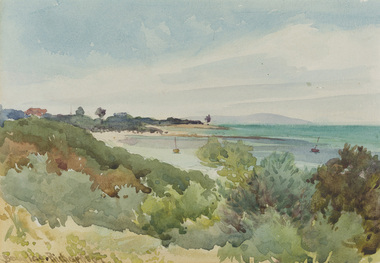
Work on paper - watercolour, Charles Douglas Richardson, Brighton Beach, 1914
watercolourlandscape, beach, brighton, coast, water, boat, charles douglas richardson, cd richardson, c douglas richardson, bayside, mountain, bay -
 Bayside Gallery - Bayside City Council Art & Heritage Collection
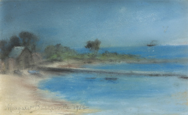
Work on paper - pastel, Margaret Baskerville, Bathing box by beach, 1912
pastelbeach, coast, bathing box, margaret baskerville, bayside, port phillip bay, jetty, ship, bush -
 Bayside Gallery - Bayside City Council Art & Heritage Collection
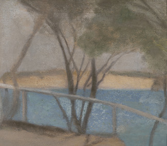
Painting - oil on composition board, Clarice Beckett, Reflected Lights, Beaumaris Bay, c. 1930-31
... Collection Corner Wilson and Carpenter Streets Brighton melbourne ...Clarice Beckett, Reflected Lights, Beaumaris Bay c.1930-31, oil on composition board, 18.2 x 24 cm. Bayside City Council Art and Heritage Collection. Purchased 2014. oil on composition boardcoast, beaumaris, bay, water, reflections, clarice beckett, beaumaris bay, lights, meldrum school, painting -
 Bayside Gallery - Bayside City Council Art & Heritage Collection
Painting - oil on board, Clarice Beckett, Cliff path, c.1929
Painted from Beaumaris Cliffs looking over to Mentone this work is a characteristic example of Beckett's ability to create a sense of place with an economy of means. The bands of floated colour create a flattened 'modern' space while still rendering a truthful impression of the location. oil on boardbeach, coast, cliff, path, tree, clarice beckett, beaumaris, beaumaris bay, bay, bayside, water, meldrum school, painting, mentone -
 Bayside Gallery - Bayside City Council Art & Heritage Collection
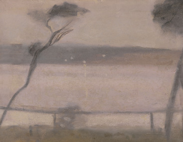
Painting - oil on composition board, Clarice Beckett, Sunset across Beaumaris Bay, c.1930-31
... Collection Corner Wilson and Carpenter Streets Brighton melbourne ...oil on composition boardbeaumaris, bay, coast, water, sunset, trees, landscape, clarice beckett, dusk, handrail, beaumaris bay, meldrum school, reflection -
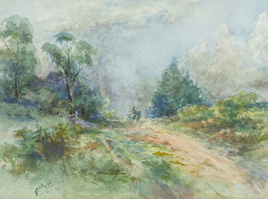
 Bayside Gallery - Bayside City Council Art & Heritage Collection
Work on paper - watercolour, Brighton Beach opposite Grimbley's Hotel
watercolourbrighton, beach, grimbley's hotel, coast, water, landscape, rocks, port philip bay, seascape -
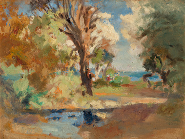
 Bayside Gallery - Bayside City Council Art & Heritage Collection
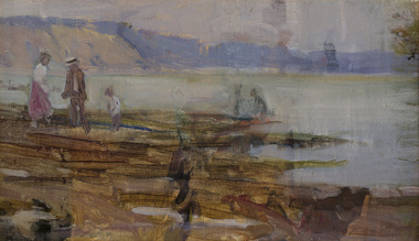
Painting - oil on canvas, Jessie Constance Alicia Traill, Beach scene, early 20th century
This work depicts the coast at Black Rock. Figures in early 20th century outfits are dotted on the oxide rocky outcrops in the foreground and beyond the water the hazy Red Bluff cliff dominates the coast.Impressionismoil on canvasbeach, coast, figures, jessie traill, red bluff, bayside, black rock, bathers, port phillip bay, bay, water -
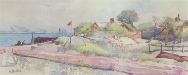 Bayside Gallery - Bayside City Council Art & Heritage Collection
Work on paper - watercolour, Elsie Barlow, Grant's Boat Shed, North Road, c.1920
watercolournorth road, brighton, coast, landscape, boat shed, elsie barlow, boat, port phillip bay -
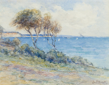 Bayside Gallery - Bayside City Council Art & Heritage Collection
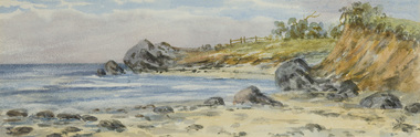
Work on paper - watercolour, William Oliver, Red Bluff at Half Moon Bay, Sandringham, 1929
watercolourcoast, water, landscape, boat, red bluff, half moon bay, sandringham, cliffs, william oliver, bayside, port phillip bay -
 Bayside Gallery - Bayside City Council Art & Heritage Collection
Work on paper - watercolour, Frederick Martin Straw, Richard Morton & Edith Rose Hand's house on Bay Road, Sandringham, 1921
Frederick Martin Straw, Richard Morton & Edith Rose Hand's house on Bay Road, Sandringham 1921, watercolour, 14 x 18.8 cm. Bayside City Council Art and Heritage Collection. Donated by Miss Mary Gillan and Dr Helen Gillan, 2008.watercolourroad, landscape, horse, sandringham, frederick martin straw, bay road, bayside, carriage, house, f.m. straw -
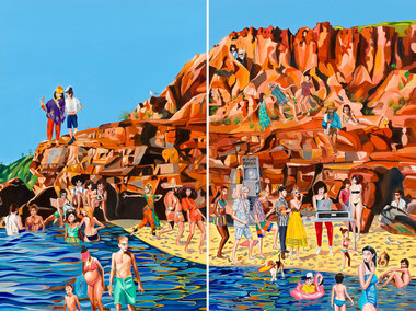 Bayside Gallery - Bayside City Council Art & Heritage Collection
Painting - oil on linen, Rob McHaffie, Word of mouth (Half Moon Bay), 2018
Word of mouth (Half Moon Bay) 2018 is a two-panel work which is the largest painting the artist has made to date. It is a colourful and fun, light-hearted scene of an imaginative party that the artist would love to attend at Half Moon Bay in Black Rock. Depicted in the work are over 30 figures, including international tourists, family and friends of McHaffie as well as famous identities such as musicians David Bowie and Solange Knowles, and fashion designer Karl Lagerfeld. McHaffie’s DJ friend Lucreccia Quintanilla has set up a DJ deck and speakers on the beach while the party goers are wading in the shallow waters, dancing on the cliff and mingling on the beach in what appears to be an idyllic summer’s day in Bayside.oil on linen (diptych)painting, beach, half moon bay, black rock, bayside, coast, party, rob mchaffie, dj, dance, musician, karl lagerfeld, david bowie, solange knowles, lucreccia quintanilla, port phillip bay, word of mouth, mooji, jon campbell, tourists, family, friends, cliff, rocks, water -
 Bayside Gallery - Bayside City Council Art & Heritage Collection
Painting - oil on canvasboard, Gregory Alexander, Ten Wednesdays at Rickett's Point, 2016-18
oil on canvasboardrickett's point, landscape, tree, vegetation, port phillip bay, bay, banksia, fence, beaumaris, bayside, gregory alexander, painting -
 Bayside Gallery - Bayside City Council Art & Heritage Collection
Painting - oil on linen, Stieg Persson, Duck and quail eggs, Italian herbs, 2015
... by Brighton’s iconic Church and Bay Streets, the artist addresses... by Brighton’s iconic Church and Bay Streets, the artist addresses ...With a career spanning over 30 years as a painter, Stieg Persson is a well known figure within the Australian and international art world. Persson’s work is celebrated for his distinct (yet eclectic) style, which consists of elements associated with abstraction, figuration and decorative art, as well as the artist’s deeply intellectual interrogation of Australian culture and society. In this work titled, Duck and quail eggs, Italian herbs, Persson reflects on contemporary parallels in changes of taste and the desire for decadence as a political and social drive. Inspired by Brighton’s iconic Church and Bay Streets, the artist addresses the social currency of luxury and high-end cuisine by depicting rococo style blackboards which offer the latest in fine dining, alcohol, exercise classes, skin treatments and lavish linens. Persson is presenting a subtle critique of the contemporary obsession with food; as contemporary society places greater significance on the connoisseurship of eating, it does so in lieu of engagement with culture as it is traditionally conceived (music, theatre, literature and art).oil on linenstieg persson, brighton, signage, graffiti, food, chalkboard, bayside, painting -
 Bayside Gallery - Bayside City Council Art & Heritage Collection
Painting - oil on board, Miles Evergood, Beaumaris, 1888
oil on boardbeaumaris, bayside, coast, landscape, miles evergood, painting, rickett's point, bay, water, shrub, trees -
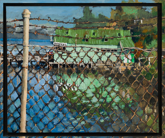 Bayside Gallery - Bayside City Council Art & Heritage Collection
Painting - acrylic on canvas, Mike Green, Keefers, 1976
In the early 1900s, Melbourne builder Charles Keefer was hired by the Moorabbin Council to build the municipal baths at Beaumaris. In 1903, Keefer took over the Beaumaris Boat House and enlarged it to form Keefer's Boat Shed where day trippers and holiday makers could hire boats and venture out into the bay. Although rebuilt following the devastating storms in 1934, Keefer’s Boat Shed was completely destroyed by fire in 1984.Realismkeefer's, boatshed, bayside, coast, beaumaris, fence, water, bay, charles keefer, pier, mike green -
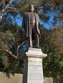 Bayside Gallery - Bayside City Council Art & Heritage Collection
Sculpture, Margaret Baskerville, Sir Thomas Bent, 1913
Arguably Margaret Baskerville’s most famous work, the bronze statue of politician and land speculator Sir Thomas Bent was Baskerville’s first public commission and a significant turning point in her career. Originally located in the centre of the Nepean Highway, in Brighton, it became somewhat of signpost for many Melbournians until it was relocated to the corner of Bay Street in 1980.The statue of Sir Thomas Bent is of historic and social significance to the State of Victoria. The statue is historically significant for commemorating Bent's long, active and infamous political career in Victoria. He was responsible for many important speculative ventures both within his electorate and in the wider context of Victoria. Although not without thought for personal gain, Bent was a committed advocate of public utilities, railways, roads, tramways and gasworks. The statue is historically significant as the first large public commission given to a woman sculptor in Victoria. This work helped the sculptor, Margaret Baskerville, preserve her name as Victoria's first professional woman sculptor. The statue is socially significant as testimony to the late nineteenth century land boom and the financial and political corruption and scandals that accompanied it. https://vhd.heritagecouncil.vic.gov.au/places/12614bronze and granite thomas bent, politician, mayor, premier, bust, sculpture, margaret baskerville, speaker, member of parliament, member of lower house, local government, councillor, brighton, public art, bayside -
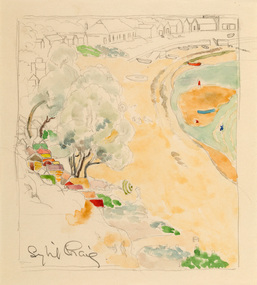 Bayside Gallery - Bayside City Council Art & Heritage Collection
Work on paper - watercolour, Sybil Craig, Half Moon Bay, c.1930
... Collection Corner Wilson and Carpenter Streets Brighton melbourne ...Sybil Craig, Half Moon Bay c.1930, pencil and watercolour, 21 x 18.8 cm. Bayside City Council Art and Heritage Collection. Purchased 2020.half moon bay, sybil craig, bayside, coast, bathing box, bathers, black rock, boat, landscape -
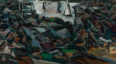 Bayside Gallery - Bayside City Council Art & Heritage Collection
Painting - acrylic on canvas, Craig Gough, Sandringham 20, 1983
acrylic on canvassandringham, craig gough, bayside, half moon bay, coast, port phillip bay, sailing, landscape, sandringham band rotunda