Showing 1505 items
matching bridge street bridge
-
 City of Ballarat Libraries
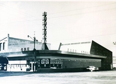
Photograph - Card Box Photographs, Dickins Food Store, Ballarat circa 1970s
... Bridge Street... and Grenville Streets before the establishment of the Bridge Mall... on the corner of Bridge and Grenville Streets before the establishment ...Dickins Food Store was located on the corner of Bridge and Grenville Streets before the establishment of the Bridge Mall. It is now Priceline Pharmacy.dickins food store, bridge mall, bridge street, grenville street, building, vehicle, commercial -
 Eltham District Historical Society Inc
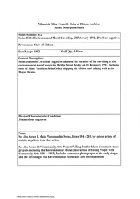
Document - Series Listing, Fraser Faithfull et al, Series 22: Environmental Mural Unveiling, 20 February 1992, 20 colour negatives, 2000
... the Bridge Street bridge on 20 February 1992. Includes shots of Shire... the Bridge Street bridge on 20 February 1992. Includes shots of Shire ...Series consists of 20 colour negatives taken on the occasion of the unveiling of the environmental mural under the Bridge Street bridge on 20 February 1992. Includes shots of Shire President John Cohen snipping the ribbon and talking with artist Megan Evans.shire of eltham archives, series listing -
 Glenelg Shire Council Cultural Collection
Photograph - Photograph - Bridge Construction, 1957
... Otway Street bridge...Black and white photo of Otway street bridge under...Front: Back- 'Bridgewater Rd Bridge - 1957 'Otway Street... Authority Archives Port of Portland Archives Otway Street bridge ...Port of Portland Authority ArchivesFront: Back- 'Bridgewater Rd Bridge - 1957 'Otway Street Bridge' - Pencilport of portland archives, otway street bridge -
 The Beechworth Burke Museum Research Collection
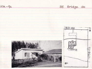
Card (Series) - Index Card, George Tibbits, 35 Bridge Street, Beechworth, 1976
... 35 Bridge Street, Beechworth...Property - 35 Bridge Street (cnr Bridge St and Albert St... Street Beechworth Property - 35 Bridge Street (cnr Bridge St ...George Tibbits, University of Melbourne. Faculty of Architecture, Building and Town & Regional PlanningIndex system that support the research for Beechworth : historical reconstruction / [by] George Tibbits ... [et al]Arranged by street names of BeechworthEach index card includes: street name and number of property, image of property, allotment and section number, property owners and dates of ownership, description of the property according to rate records, property floor plan with dimensions.beechworth, george tibbitsbeechworth, george tibbits -
 Eltham District Historical Society Inc
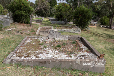
Photograph, Peter Pidgeon, Grave of Richard George, Emily Ann (nee Davis) and Edith Jane Kaylock, Eltham Cemetery, Victoria, 5 April 2021
... Brougham Street Bridge... years the Brougham Street bridge was generally known... side. For many years the Brougham Street bridge was generally ...In his early adult life, Richard Kaylock worked as a whaler (visiting California and New Zealand) and later as a drover on a large cattle station in New South Wales. In 1848 he came to Melbourne, working as a slaughterman, then settled in Eltham in 1854, his occupation thereafter being variously recorded as butcher or orchardist. He also had some experiences at Ballarat during the Eureka Rebellion. He died in 1910 at the age of 84. His obituary described him as a "striking personality" who was "brusque to a fault" and "strictly upright, expecting others to be the same". It seems from his will that he was illiterate. He is buried in Eltham Cemetery with his wife Emily. His property was in Wellington Street (now Brougham Street) and apparently extended across the Diamond Creek. The land on the western side of the creek was farmed, the house being on the eastern side. For many years the Brougham Street bridge was generally known as "Kaylock's Bridge". It formed part of the original coach road to Eltham and in 1922 was described as an "old rustic bridge". Its low level and insubstantial construction made it susceptible to flood damage, necessitating frequent closures until repairs could be carried out. The original bridge was demolished in 1923 and replaced by a "new up-to-date" one. When a lack of finances delayed repairs to the Bridge Street bridge in 1931, traffic had to detour via Brougham Street for some time. Local residents feared that the Bridge Street bridge might never reopen. In Loving Memory Of Our Dear Father & Mother R.G. and E.A. Kaylock Also E.J. Kaylock Died 21st Jan. 1927 The Eternal God Is My PledgeBorn Digitaleltham cemetery, gravestones, brougham street bridge, edith jane kaylock, emily ann kaylock (nee davis), kaylocks bridge, richard george kaylock -
 The Beechworth Burke Museum Research Collection
Card (Series) - Index Card, George Tibbits, 2 Bridge Street, Beechworth, 1976
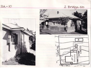
... 2 Bridge Street, Beechworth...Property - 2 Bridge Street (cnr Bridge St and Gorge Rd... Street Beechworth Property - 2 Bridge Street (cnr Bridge St ...George Tibbits, University of Melbourne. Faculty of Architecture, Building and Town & Regional PlanningIndex system that support the research for Beechworth : historical reconstruction / [by] George Tibbits ... [et al]Arranged by street names of BeechworthEach index card includes: street name and number of property, image of property, allotment and section number, property owners and dates of ownership, description of the property according to rate records, property floor plan with dimensions.beechworth, george tibbitsbeechworth, george tibbits -
 The Beechworth Burke Museum Research Collection
Card (Series) - Index Card, George Tibbits, 35A Bridge Street, Beechworth, 1976
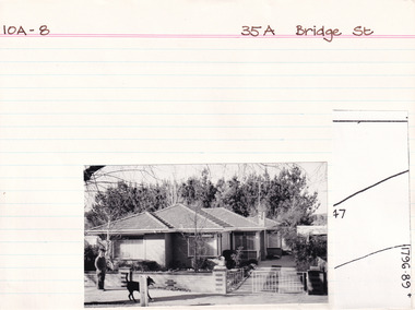
... 35A Bridge Street, Beechworth...Property - 35A Bridge Street (cnr Bridge St & Albert St... Street Beechworth Property - 35A Bridge Street (cnr Bridge St ...George Tibbits, University of Melbourne. Faculty of Architecture, Building and Town & Regional PlanningIndex system that support the research for Beechworth : historical reconstruction / [by] George Tibbits ... [et al]Arranged by street names of BeechworthEach index card includes: street name and number of property, image of property, allotment and section number, property owners and dates of ownership, description of the property according to rate records, property floor plan with dimensions.beechworth, george tibbitsbeechworth, george tibbits -
 The Beechworth Burke Museum Research Collection
Card (Series) - Index Card, George Tibbits, 1 Bridge Street, Beechworth, 1976
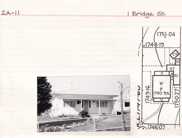
... 1 Bridge Street, Beechworth...Property - ! Bridge Street (cnr Bridge St and Mellish St... Street Beechworth Property - ! Bridge Street (cnr Bridge St ...George Tibbits, University of Melbourne. Faculty of Architecture, Building and Town & Regional PlanningIndex system that support the research for Beechworth : historical reconstruction / [by] George Tibbits ... [et al]Arranged by street names of BeechworthEach index card includes: street name and number of property, image of property, allotment and section number, property owners and dates of ownership, description of the property according to rate records, property floor plan with dimensions.beechworth, george tibbitsbeechworth, george tibbits -
Eltham District Historical Society Inc
Photograph, Diamond Creek floods 1953, 1953
... showing concrete bridge, Eltham South, Diamond Street bridge..., Diamond Street bridge and Glen Park bridge Diamond Creek floods ...Three photographs of Diamond Creek in flood 21/10/1953 showing concrete bridge, Eltham South, Diamond Street bridge and Glen Park bridgediamond creek, floods, eltham, bridges, main road, wattletree road, diamond street, glen park -
Port Melbourne Historical & Preservation Society
Photograph - Queen Street Bridge, Melbourne, 1990s
... Queen Street Bridge, Melbourne...Colour photograph taken from under King Street Bridge... King Street Bridge, looking towards Queen Street Bridge ...Colour photograph taken from under King Street Bridge, looking towards Queen Street Bridge with the Yarra River in foreground and the city skyline in backgroundbuilt environment, engineering - bridges -
 The Beechworth Burke Museum Research Collection
Card (Series) - Index Card, George Tibbits, 10 Bridge Street, Beechworth, 1976
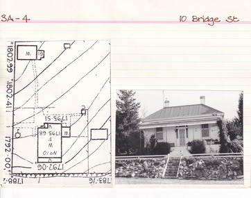
... 10 Bridge Street, Beechworth...Property - 10 Bridge Street (cnr Bridge & Victoria Sts... Street Beechworth Property - 10 Bridge Street (cnr Bridge ...George Tibbits, University of Melbourne. Faculty of Architecture, Building and Town & Regional PlanningIndex system that support the research for Beechworth : historical reconstruction / [by] George Tibbits ... [et al]Arranged by street names of BeechworthEach index card includes: street name and number of property, image of property, allotment and section number, property owners and dates of ownership, description of the property according to rate records, property floor plan with dimensions.beechworth, george tibbitsbeechworth, george tibbits -
 Kew Historical Society Inc
Photograph - Johnston Street Bridge, 1952
... Johnston Street Bridge...Johnston Street Bridge before new bridge constructed. Bus.... Johnston Street Bridge before new bridge constructed. Bus on bridge ...An item from an outstanding and diverse photographic collection, assembled by members of the Christian and Washfold families of Kew.Johnston Street Bridge before new bridge constructed. Bus on bridge, Abbotsford Convent on left and Melbourne skyline in distance. St Ignatius, Richmond without steeple. -
 The Beechworth Burke Museum Research Collection
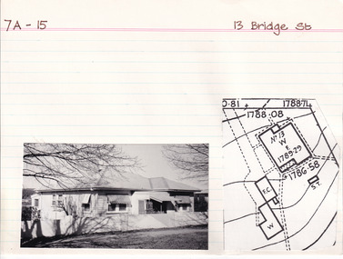
Card (Series) - Index Card, George Tibbits, 13 Bridge Street, Beechworth, 1976
... 13 Bridge Street, Beechworth...Property - 13 Bridge Street (cnr Bridge & Victoria Sts... Street Beechworth Property - 13 Bridge Street (cnr Bridge ...George Tibbits, University of Melbourne. Faculty of Architecture, Building and Town & Regional PlanningIndex system that support the research for Beechworth : historical reconstruction / [by] George Tibbits ... [et al]Arranged by street names of BeechworthEach index card includes: street name and number of property, image of property, allotment and section number, property owners and dates of ownership, description of the property according to rate records, property floor plan with dimensions.beechworth, george tibbitsbeechworth, george tibbits -
 The Beechworth Burke Museum Research Collection
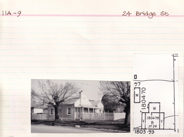
Card (Series) - Index Card, George Tibbits, 24 Bridge Street, Beechworth, 1976
... 24 Bridge Street, Beechworth...Property - 24 Bridge Street (cnr Bridge & Albert Sts... Street Beechworth Property - 24 Bridge Street (cnr Bridge ...George Tibbits, University of Melbourne. Faculty of Architecture, Building and Town & Regional PlanningIndex system that support the research for Beechworth : historical reconstruction / [by] George Tibbits ... [et al]Arranged by street names of BeechworthEach index card includes: street name and number of property, image of property, allotment and section number, property owners and dates of ownership, description of the property according to rate records, property floor plan with dimensions.beechworth, george tibbitsbeechworth, george tibbits -
 The Beechworth Burke Museum Research Collection
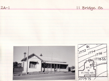
Card (Series) - Index Card, George Tibbits, 11 Bridge Street, Beechworth, 1976
... 11 Bridge Street, Beechworth...Property - 11 Bridge Street (cnr Bridge St & Victoria St... Street Beechworth Property - 11 Bridge Street (cnr Bridge St ...George Tibbits, University of Melbourne. Faculty of Architecture, Building and Town & Regional PlanningIndex system that support the research for Beechworth : historical reconstruction / [by] George Tibbits ... [et al]Arranged by street names of BeechworthEach index card includes: street name and number of property, image of property, allotment and section number, property owners and dates of ownership, description of the property according to rate records, property floor plan with dimensions.beechworth, george tibbitsbeechworth, george tibbits -
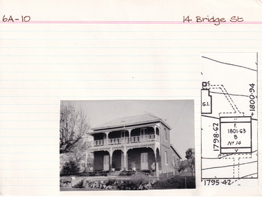 The Beechworth Burke Museum Research Collection
Card (Series) - Index Card, George Tibbits, 14 Bridge Street, Beechworth, 1976
... 14 Bridge Street, Beechworth...Property - 14 Bridge Street (cnr Bridge & Victoria Sts... Street Beechworth Property - 14 Bridge Street (cnr Bridge ...George Tibbits, University of Melbourne. Faculty of Architecture, Building and Town & Regional PlanningIndex system that support the research for Beechworth : historical reconstruction / [by] George Tibbits ... [et al]Arranged by street names of BeechworthEach index card includes: street name and number of property, image of property, allotment and section number, property owners and dates of ownership, description of the property according to rate records, property floor plan with dimensions.beechworth, george tibbitsbeechworth, george tibbits -
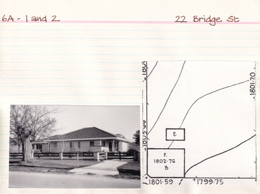 The Beechworth Burke Museum Research Collection
Card (Series) - Index Card, George Tibbits, 22 Bridge Street, Beechworth, 1976
... 22 Bridge Street, Beechworth...Property - 22 Bridge Street (cnr Bridge and Albert Sts... Street Beechworth Property - 22 Bridge Street (cnr Bridge ...George Tibbits, University of Melbourne. Faculty of Architecture, Building and Town & Regional PlanningIndex system that support the research for Beechworth : historical reconstruction / [by] George Tibbits ... [et al]Arranged by street names of BeechworthEach index card includes: street name and number of property, image of property, allotment and section number, property owners and dates of ownership, description of the property according to rate records, property floor plan with dimensions.beechworth, george tibbitsbeechworth, george tibbits -
 Eltham District Historical Society Inc
Postcard - Photograph postcard, Old Bridge, Kaylock's Crossing, Brougham Street, Eltham, c.1912
... Old Bridge, Kaylock's Crossing, Brougham Street, Eltham... of the street. It is not known when the first bridge was constructed... of the street. It is not known when the first bridge was constructed ...Date estimated to be circa 1912 based on the style of printing on the reverse of the card - Kodak Austral paper for real photo postcards, the paper was manufactured c.1908-1914 (See also POSTCARDS ON KODAK PAPER - IS IT POSSIBLE TO "DATE" THEM? http://tps.org.au/bb/viewtopic.php?t=115) Brougham Street was created in Josiah Holloway's 1851 subdivision of Little Eltham. It was one of several east-west streets shown on the subdivision plan as crossing the Diamond Creek. The western part was named Wellington Street on the subdivision plan but was later changed to conform with the name of the eastern part as acknowledgement of the continuity of the street. It is not known when the first bridge was constructed in Brougham Street however it was certainly mentioned at Council’s meeting of 2 June 1884 as being in a dangerous state of repair. This photo (c.1895) of an old bridge shows a very low-level simple log girder bridge crossing the creek at a right angle and so the approaches involved bends in the road alignment. This bridge was generally known as Kaylocks Bridge or Kaylock’s Crossing after the owner of the adjoining land. It was most likely built from around the mid-1850s, or a crossing of some fashion established as Richard George Kaylock, butcher of Little Eltham and his wife Emily Ann settled there in 1854. His property was in Wellington Street (now Brougham Street) and apparently extended across the Diamond Creek. The land on the western side of the creek was farmed, the house being on the eastern side. Kaylock's Bridge formed part of the original coach road to Eltham and in 1922 was described as an "old rustic bridge". Its low level and insubstantial construction made it susceptible to flood damage, necessitating frequent closures until repairs could be carried out. In September 1922, Council called for tenders for a new timber bridge to be constructed at Kaylock’s crossing. An engineering assessment carried out for the Council by Macleod Consulting at the time of the replacement suggested that the construction details indicate that it was in the 1900s, however this dating could possibly have been the result of numerous repairs undertaken over the years to flood damage. The tender was awarded to Mr Weller of Kangaroo Ground who commenced work in February 1923 on a higher-level timber trestle bridge. Work was slowed due to illness of the contractor and the accidental death of a man in March 1923 following the collapse of the bank after he had jumped into a hole that had just been blasted. The bridge was completed around July 1923 at which point the old structure was pulled up, marking what was described in the ‘Advertiser’ newspaper as the passing of an old and well-loved landmark in the district. In April 1924 the approach to Kaylocks bridge was washed away during the heavy flooding that destroyed the Main Road bridge. The western side was repaired, and an extra span was added to the eastern side using timber from the destroyed Main Road bridge. The bridge was again severely damaged four months later in August 1924 When a lack of finances delayed repairs to the Bridge Street bridge in 1931 (also referred to as Obelisk Bridge at the time), traffic had to detour via Brougham Street for some time. Local residents feared that the Bridge Street bridge might never reopen. Kaylocks Bridge was constantly subject to damage by floods. In the 1934 flood it was submerged by two feet of water. In more recent times the bridge was again severely damaged by flooding and repairs made. A new bridge and adjoining footbridge were constructed in 2009.Digital file only Postcards scanned from the collection of Michael Aitken on loan to EDHS, 2 Sep. 2022michael aitken collection, eltham, postcards, bridge, brougham street, diamond creek (creek), kaylocks bridge, wellington street -
 Eltham District Historical Society Inc
Photograph, Old Bridge, Kaylock's Crossing, Brougham Street, Eltham, c.1895
... Old Bridge, Kaylock's Crossing, Brougham Street, Eltham... the first bridge was constructed in Brougham Street however... the first bridge was constructed in Brougham Street however ...Brougham Street was created in Josiah Holloway's 1851 subdivision of Little Eltham. It was one of several east-west streets shown on the subdivision plan as crossing the Diamond Creek. The western part was named Wellington Street on the subdivision plan but was later changed to conform with the name of the eastern part as acknowledgement of the continuity of the street. It is not known when the first bridge was constructed in Brougham Street however it was certainly mentioned at Council’s meeting of 2 June 1884 as being in a dangerous state of repair. This photo (c.1895) of an old bridge shows a very low-level simple log girder bridge crossing the creek at a right angle and so the approaches involved bends in the road alignment. This bridge was generally known as Kaylocks Bridge or Kaylock’s Crossing after the owner of the adjoining land. It was most likely built from around the mid-1850s, or a crossing of some fashion established as Richard George Kaylock, butcher of Little Eltham and his wife Emily Ann settled there in 1854. His property was in Wellington Street (now Brougham Street) and apparently extended across the Diamond Creek. The land on the western side of the creek was farmed, the house being on the eastern side. Kaylock's Bridge formed part of the original coach road to Eltham and in 1922 was described as an "old rustic bridge". Its low level and insubstantial construction made it susceptible to flood damage, necessitating frequent closures until repairs could be carried out. In September 1922, Council called for tenders for a new timber bridge to be constructed at Kaylock’s crossing. An engineering assessment carried out for the Council by Macleod Consulting at the time of the replacement suggested that the construction details indicate that it was in the 1900s, however this dating could possibly have been the result of numerous repairs undertaken over the years to flood damage. The tender was awarded to Mr Weller of Kangaroo Ground who commenced work in February 1923 on a higher-level timber trestle bridge. Work was slowed due to illness of the contractor and the accidental death of a man in March 1923 following the collapse of the bank after he had jumped into a hole that had just been blasted. The bridge was completed around July 1923 at which point the old structure was pulled up, marking what was described in the ‘Advertiser’ newspaper as the passing of an old and well-loved landmark in the district. In April 1924 the approach to Kaylocks bridge was washed away during the heavy flooding that destroyed the Main Road bridge. The western side was repaired, and an extra span was added to the eastern side using timber from the destroyed Main Road bridge. The bridge was again severely damaged four months later in August 1924 When a lack of finances delayed repairs to the Bridge Street bridge in 1931 (also referred to as Obelisk Bridge at the time), traffic had to detour via Brougham Street for some time. Local residents feared that the Bridge Street bridge might never reopen. Kaylocks Bridge was constantly subject to damage by floods. In the 1934 flood it was submerged by two feet of water. In more recent times the bridge was again severely damaged by flooding and repairs made. A new bridge and adjoining footbridge were constructed in 2009. Part of a slide show presentation "Bridges & Waterways of the Shire" by Russell Yeoman to the 13 September 1989 Society meeting. The presentation included slides of historic photos from the Shire of Eltham Pioneers collections as well as several recent views.Photo of earliest known crossing of the Diamond Creek at brougham StreetPostcard photo printbrougham street, eltham, wellington street, kaylocks bridge, bridge, diamond creek (creek) -
 Eltham District Historical Society Inc
Negative - Photograph, Eltham War Memorial Obelisk 1914-1918, cnr. Main Road and Bridge Street, c.1925
... Bridge Street...Bridge Street... of the name Obelisk Corner, the Bridge Street bridge was also known... of the name Obelisk Corner, the Bridge Street bridge was also known ...Located on what was referred to as Obelisk Corner, improvements have been been made since the unveiling in August 1919 with the provision of a stone retaining wall topped with a chain link and granite stone boundary, most likely in conjunction with improvements to the intersection into Main Road. Along with the use of the name Obelisk Corner, the Bridge Street bridge was also known as Obelisk Bridge. The Eltham Obelisk was originally located at the corner of Bridge and Main Roads in 1919. In 1943 (WW2) the local community commenced plans to establish the Eltham War Memorial, a living memorial to benefit the children as opposed to a one in stone as per the obelisk. The Eltham War Memorial Trust was established in 1945. In 1947 the Trust intended for the Obelisk to be relocated from Bridge Street and Main Road to the Garden of Remembrance which was planned as part of the Baby Health Centre which was to be the first of three buildings of the Eltham War Memorial to be built in 1951. In 1951 the Eltham RSL was invited to be represented on the Eltham War Memorial Trust. Around this time, with pending roadworks, the obelisk was relocated to the front garden of the Eltham RSL sub branch on Main Road for safe keeping. In 2007, a suggestion was proposed by Harry Gilham (President, EDHS) to John Cohen (ERSL) to claim a special site along with the historic Shillinglaw trees on the now vacant former Eltham Shire Office site adjacent to the Eltham War Memorial precinct for relocation of the obelisk. In 2010 following the financial collapse and sale of the Eltham RSL Sub-Branch property and amalgamation with the Montmorency Eltham RSL sub-branch, the location of the obelisk was again in immediate jepoardy and in conjunction with Nillumbik Shire Council, the obelisk was relocated in front of the Eltham War Memorial buildings in preparation for the Dawn Service on Anzac Day 2012.This photo forms part of a collection of photographs gathered by the Shire of Eltham for their centenary project book,"Pioneers and Painters: 100 years of the Shire of Eltham" by Alan Marshall (1971). The collection of over 500 images is held in partnership between Eltham District Historical Society and Yarra Plenty Regional Library (Eltham Library) and is now formally known as the 'The Shire of Eltham Pioneers Photograph Collection.' It is significant in being the first community sourced collection representing the places and people of the Shire's first one hundred years.Digital image 4 x 5 inch B&W Negsepp, shire of eltham pioneers photograph collection, eltham, main road, eltham war memorial, bridge street, obelisk, obelisk corner -
 Eltham District Historical Society Inc
Photograph, Eltham War Memorial 1914-1918. Cnr. Main Road and Bridge Street, 3 August 1919
... Eltham War Memorial 1914-1918. Cnr. Main Road and Bridge...bridge street... of the Obelisk at the corner of Bridge Street and Main Road became known... of the Obelisk at the corner of Bridge Street and Main Road became known ...Dated 1919, the Eltham Obelisk is decorated with wreaths, most likely for what was originally known as Armistice Day though now known as Remembrance Day, 11 November. The location of the Obelisk at the corner of Bridge Street and Main Road became known as Obelisk Corner and the Bridge Street bridge was also referred to as Obelisk Bridge. The Eltham Obelisk was originally located at the corner of Bridge and Main Roads in 1919. In 1943 (WW2) the local community commenced plans to establish the Eltham War Memorial, a living memorial to benefit the children as opposed to a one in stone as per the obelisk. The Eltham War Memorial Trust was established in 1945. In 1947 the Trust intended for the Obelisk to be relocated from Bridge Street and Main Road to the Garden of Remembrance which was planned as part of the Baby Health Centre which was to be the first of three buildings of the Eltham War Memorial to be built in 1951. In 1951 the Eltham RSL was invited to be represented on the Eltham War Memorial Trust. Around this time, with pending roadworks, the obelisk was relocated to the front garden of the Eltham RSL sub branch on Main Road for safe keeping. In 2007, a suggestion was proposed by Harry Gilham (President, EDHS) to John Cohen (ERSL) to claim a special site along with the historic Shillinglaw trees on the now vacant former Eltham Shire Office site adjacent to the Eltham War Memorial precinct for relocation of the obelisk. In 2010 following the financial collapse and sale of the Eltham RSL Sub-Branch property and amalgamation with the Montmorency Eltham RSL sub-branch, the location of the obelisk was again in immediate jepoardy and in conjunction with Nillumbik Shire Council, the obelisk was relocated in front of the Eltham War Memorial buildings in preparation for the Dawn Service on Anzac Day 2012.This photo forms part of a collection of photographs gathered by the Shire of Eltham for their centenary project book,"Pioneers and Painters: 100 years of the Shire of Eltham" by Alan Marshall (1971). The collection of over 500 images is held in partnership between Eltham District Historical Society and Yarra Plenty Regional Library (Eltham Library) and is now formally known as 'The Shire of Eltham Pioneers Photograph Collection.' It is significant in being the first community sourced collection representing the places and people of the Shire's first one hundred years.Digital image 4 x 5 inch B&W Negsepp, shire of eltham pioneers photograph collection, eltham, main road, bridge street, eltham war memorial, obelisk, obelisk corner, wreath -
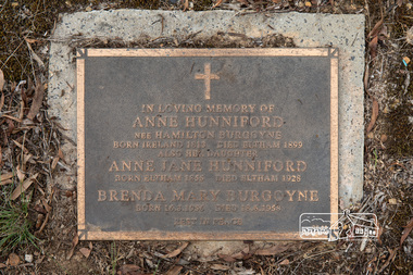 Eltham District Historical Society Inc
Photograph, Peter Pidgeon, Grave of Anne Hunniford (nee Hamilton Burgoyne) and Anne Jane Hunniford, Eltham Cemetery, Victoria, 5 April 2021
... in Maria Street (now Main Road) near Bridge Street (originally... in Maria Street (now Main Road) near Bridge Street (originally ...On February 1, 1854, the first Eltham Post Office was established. At that time, the number of permanent residents would have been fairly small, probably less than 200. In 1855 Thomas Hunniford was appointed as Eltham's postmaster (replacing Frederick Falkiner). He operated the post office from his general store in Maria Street (now Main Road) near Bridge Street (originally facing Bridge Street but later altered to face Main Road). His daughter, Miss Anne Hunniford, was a teacher at Eltham Primary School in her early adult years. Sometime between 1864 and 1868 the management of the post office passed from Thomas Hunniford to his daughter, Anne who managed the Eltham Post Office until illness forced her to retire in 1928. A big improvement in communication was provided for Eltham residents when a telegraph office was established at the post office in 1877. During 1923 a manual telephone exchange was provided at Eltham, the first two subscribers being J.J. O’Connor and Eltham Police Station. Anne was succeeded by her nephew Neville Burgoyne whose family were then running the store, which had been rebuilt and modernised in 1926 to accommodate an expanded post and telegraph office. Anne knew everyone and was respected for her kindly actions in her official and private capacities. In her time there was no official letter delivery to houses; residents were expected to collect their mail at the post office. But if an important letter or telegram arrived, Anne would try to find someone willing to deliver it. Jock Read recalled he started his own private "mail run"; he would charge people 1/- per week to take their letters to the post office for mailing and would return with their mail. Anne died in 1928, aged 73. She is buried in Eltham Cemetery with her mother and with a Burgoyne child born much later. Burgoyne's store was further extended in 1940 and still stands though has undergone several modifications and businesses. In 1954 the post office moved to a shop in the main Eltham shopping centre, then in 1958 a purpose-built post office was opened near the entrance to the railway station. In Loving Memory of Anne Hunniford Nee Hamilton Burgoyne Born Ireland 1813 Died Eltham 1899 Also her daughter Anne Jane Hunniford Born Eltham 1855 Died Eltham 1928 Brenda May Burgoyne Born 16. 8. 1956 Died 18. 6. 1958 Rest In PeaceBorn Digitaleltham cemetery, gravestones, anne hunniford (nee hamilton burgoyne), anne jane hunniford, brenda mary burgoyne -
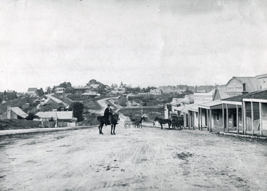 The Beechworth Burke Museum
Photograph, c1900
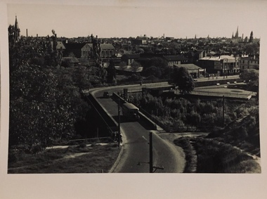
... of another hill. This image is looking down Bridge Street, Newtown...Bridge Street, Newtown, Victoria, Australia... of another hill. This image is looking down Bridge Street, Newtown ...Believed to have been taken sometime between 1858 and 1908, featuring a man with moustache, dressed in hat and long riding coat, seated on a bob-tailed horse, is stopped in the middle of a wide dirt road in Beechworth. He is outside a row of businesses, including R.McKenzie & Sons Grain Store and Mackenzie Family Store (Wholesale & Retail Est. 1855), along a sloping hill. Behind the main rider are a parked horse and laden two-wheeled cart backed up directly outside the grain store's verandah, and another man is driving a horse and four-wheeled wagon forward towards them. At the bottom of the hill is a bridge (Newtown Bridge) with forked road on the far side, leading to a number of houses on both sides of another hill. This image is looking down Bridge Street, Newtown, Beechworth and across to Ford Street (left) and High Street (right). Road-making was a focus of town development during the 1850s, and the wide streets were created on the instructions of the surveyor-general to be between sixty-six and ninety-nine feet wide to give the town a pleasing aspect.This photograph is important in showing the development and expansion of the various businesses and buildings in Bridge Street of Newtown, Beechworth. Black and white rectangular photograph printed on paperReverse: 6980/ PH 118/ 1998.00059/beechworth, new town, newtown, newtown beechworth, local business, mackenzie family store, mackenzie's family store, mackenzie, grain store, bridge, ford steet, high street, colonial australia, australian gold rushes, mining technology, beechworth historic district, indigo gold trail, migration, indigo shire, mckenzie and sons grainstore, mckenzie family store, mckenzie, newtown bridge -
 The Beechworth Burke Museum
Postcard, c. Early 1900s
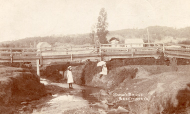
Taken in the early 1900s, the postcard depicts two girls dressed in old style, white knee length dress which was common for this period for young women. This compared to the ankle length styles which were acceptable for adult women. We can also see an example of early bridge construction and engineering, notably made from timber rather than from stone or steel, noted in the postcard as Snow's Bridge. Sepia rectangular postcard printed on card Obverse: Snow's Bridge/Beechworth Reverse: Dear Julie/ I received your pretty PB/ We haven't gone away yet. Mr Stokes/ asked me were you going to be/ married. He wished you luck/ (I wonder/ if he meant it.) We sent the Magpie to Annie to-day. I haven't got any/ word about going to a [unknown]/ yet. We had a great Friendly Societies/ day yesterday but it rained a bit/ Sally is going to get a [illegible] silk/ dress. When are you to be married?/ Mr Pounceby is back at Allen's shop./ [unknown]. We are going to Belle's for a [unknown] if we can. With Love from Lilly. bridge, beechworth, snow's bridge, children, childhood, postcard -
 The Beechworth Burke Museum
Photograph - Stereoscopic Photograph, Unknown c1875
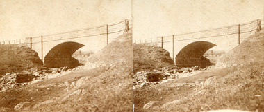
Depicted in the photograph is Newtown Bridge or the Newtown Falls Bridge, in Beechworth, Victoria. Noted for its location, detailed craftsmanship and stonemasonry by Scottish stonemasons the Newtown Bridge was built in the 19th century provincial town of Beechworth (completed in 1875). The bridge was built over Spring Creek, spanning 6.3 meters wide and 24.8 meters tall. Beechworth held a distinct role in the administrative and commercial management of Victoria's north-eastern goldfields, with many objects and structures still well preserved from the towns establishment. The bridge indicates the growth of the town, replacing a previous timber structure as well as its association to the mining activity in the area and the rapid increase in Australia's economy that led to investment and development of roads and railways. The local granite used in the construction of the single arch Newtown Bridge makes the bridge and other buildings made with the granite unique to the area, the honey-toned material distinct to Beechworth. This photograph is historically significant as it provides insight into the industrial development of Beechworth and the surrounding area, contributed to by the goldfields. The photograph further captures the representation of vernacular engineering traditions and Scottish stonemasonry.Two sepia-toned rectangular photographs featuring a bridge in the background printed on matte photographic paper mounted on card.Reverse: 97.2324/ Newtown Bridge/ Beechworthbridge, newtown beechworth, newtown bridge, newtown, beechworth, beechworth falls bridge, beechworth mining district, spring creek, -
 The Beechworth Burke Museum
Postcard, Early 1900s
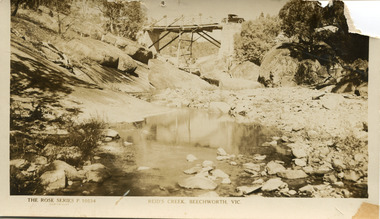
A postcard taken of Reid's Creek in Beechworth, taken in the early 1900s. This image is a representation of early automboile usage in the Beechworth area, with the car crossing the Reid's Creek bridge. Taken in Sepia tone it also has a detailed look of the foundations of the early bridge.Sepia rectangular photograph printed on matte photograph paperObverse The Rose Series P.10534 / Copyright Reid's Creek, Beechworth, Vic Reverse Left Side of Reverse: Published by the Rose Stereograph / Armadale, Victoria Top of Reverse: Post Card /Printed drawing of a rose The “Rose” Series / De Luxe A Real Photograph / Produced in Australia 1997.2607 Tanley Lower Right of Reverse: 2906 automobile, bridge, reid's creek, beechworth, postcard -
 The Beechworth Burke Museum
Photograph
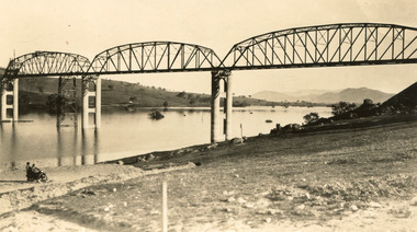
Taken between 1928 and 1930, depicted is the Bethanga Bridge under construction. The Bridge was completed in 1930 and was built to assist residents of the Bethanga district to travel to Albury. Other bridges would become submerged by the backed-up water of the Murray and Mitta Rivers so the Bethanga bridge was built two miles above the Mitta Weir. The Bethanga Bridge was built north of the future Hume Dam which would be completed in 1936. At 2430 feet long, Bethanga Bridge was the longest road bridge in Australia at the time of its completion. The Bridge is 20 feet wide and made up of nine 270 feet long spans. Materials used include ten tons of paint for the steel works; 1600 tons of steel; 900 tons of timber for the decking; and reinforced concrete for the piers. The tender for the construction was awarded to C. Ruwolt Pty. Ltd., engineers who were located on Victoria Street, West Richmond. The contract was awarded for £71,890. It was predicted between 250 and 300 men would find employment on the project. The news was well received by trade unions at the time as there had been a drop in available engineering work.This photograph is historically significant as it depicts the progress of the Bethanga Bridge construction, which was important infrastructure for the area. It is also a good example of methods used in the area to assist in travel over the river prior to the construction of the Hume Dam.Black and white rectangular photo printed on matte photographic paper.Reverse: 1997 3186 / 84-19-3 / This is the bridge. / It is not yet open to traffic / yet. will not be completed / until May next / It is a wonderful bridge the / pillars are 100 feet high. / KODAK PRINT Envelope Obverse: Peterson PHOTO / Hume Weir Envelope Reverse: BMM 84-20-1,2+3. bethanga bridge, lake hume, hume dam, hume weir, murray river, bridge, bethanga, albury -
 The Beechworth Burke Museum
Photograph, Unknown c.1930s
This image shows Bethanga Bridge, which was constructed between 1927 and 1930 in Albury, NSW. The bridge was a necessity due to the building of the Hume Dam (Wier), 1919-1936. Bethanga Bridge is a long, nine-span, riveted-steel, variable depth, Pratt Truss road bridge of nine principal spans of 82 metres and a total length of 752 metres over the flooded valley of the Murray River, now part of Hume Reservoir. Because of its unique location, over the waters of a dam with the border running down the centre of the body of water, the Bethanga bridge is the only built structure shared by both New South Wales and Victoria. It was built 1.6 kilometres upstream of the dam and in 1961 was raised 300mm, with a concrete deck replacing the original wooden deck. The State Rivers and Water Supply Commission of Victoria and the New South Wales Department of Public Works were responsible for the construction works for the Hume Weir under the River Murray Waters Agreement. It is apparent that a similar joint arrangement was made for the construction of the Bethanga Bridge as part of the Hume Weir works.This photograph of the Bethanga Bridge is of historical significance as it showcases the architectural skills of Percy Allen and Vincent Packer. Additionally, it reveals the environmental landscape of the 1920s-1930s, is linked to the Hume Dam and both New South Wales and Victorian heritage. Unmounted black and white rectangular photograph. Reverse: 1997.3196 84-20-3bethanga, bethanga bridge, hume dam, pratt truss, murray river, hume weir, transportation -
 The Beechworth Burke Museum
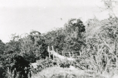
Photograph
This rectangle black and white photograph shows a bush scene with part of a suspension rope and wooden plank bridge visible in the middle of the image. It is likely this suspension bridge was used by the Tannery workers to move between the town and the Ovens Tannery located South-West of Beechworth due to its secluded bush location, the bridge likely spanned the gorge across Spring creek. The tannery itself was located alongside Gimlet Creek, about three kilometres from town, down what is now known as Malakoff and Old Tannery Road but which at the time was remote and accessed through bushland. The Ovens tannery was stablished in 1858 by Matthew Dodd and Hallahan and later Matthew and his brother Thomas Dodd in 1866 who developed it over the years. According to Doyle, 'we have little information about its early operations except the tannery itself comprised four small buildings' by 1870 ‘a small village with gardens of vines and fruit trees surrounded the tannery’ (Woods, 121), and by 1887 the Tannery employed fifteen men. The Ovens tannery was among several new businesses establishing themselves such as a foundry that brought industrial manufacturing alongside the developing township and which strengthened the economic stability of Beechworth after the receding mining surge. According to Woods (p. 121) in the 1860’s the government spent considerable sums to establish several public buildings such as the Benevolent Asylum, the Hospital and Insane Asylum to support those in need of care in the area directly after the Indigo gold rush which had left Beechworth, a fairly remote regional and newly formed township (Gold was first discovered in Beechworth in 1852) with a number of infirm and destitute people in its wake and which due to the support and establishment of these facilities ‘made Beechworth a significant social welfare centre in Victoria’ (Woods, p. 121). The tannery provided employment and connected the regional centre with other parts of Victoria and the wider colonial outposts and would have been a welcome opportunity for those seeking work after gold was no longer a source of income.A good example of the ingenuity of regional settlers to achieve what would have been a difficult and remote construction of a bridge as a means of access. This bridge is evidence of planning and forethought and shows dedication to establishing a life in a remote landscape.Black and white rectangular photograph printed on paperreverse: / 2983 / / BMM2983 /black and white photograph, bush, suspension bridge, rope bridge, tannery, spring creek, ovens tannery, bushland, gimlet creek, matthew dodd, beechworth -
 The Beechworth Burke Museum
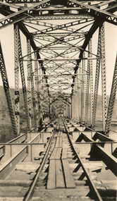
Photograph, c. 1927 - 1930
Taken during the construction of the Bethanga Bridge (1927-1930), this sepia photograph shows a view of the incomplete bridge taken from inside the structure and looking down the span of the bridge from where the photographer stands. The photograph depicts an incomplete deck, with loose-looking wooden planks/panels lain along the centre in groups of three. Once complete, the original decking of the bridge was made of timber before being replaced by cement in 1961 (Victorian Heritage Database).Bethanga Bridge is of historical significance to the Indigo Shire for its associations with the construction of Hume Dam, its associations with the River Murray Waters Agreement and the River Murray Commission, and illustration of the needs and influence of the farming communities along the river in this area - particularly in relation to the building of the Weir. It also represents the collaboration between New South Wales and Victoria on a large infrastructure project, being the only built structure shared by both New South Wales and Victoria due to its location. also reflecting on the Shire's geographical closeness to this neighboring state. This photograph is part of a series that documents the construction of this well-known heritage site of significance to the Indigo Shire. It reflects upon a period of growth and change in the area.Sepia, rectangular photograph printed on matt photographic paper, unmountedReverse: 1997.3190 / Another snap of the bridge. taken on the bridge showing huge steel sides / 84-19-4 / V [in circle] 354 / KODAK PRINTbethanga bridge, hume dam, bridges album, construction, road construction, hume weir