Showing 208 items
matching bridges - victoria - history
-
 Glenelg Shire Council Cultural Collection
Photograph - Photograph - Casterton, Victoria, c. 1963
SOURCED FROM CASTERTON TOWN HALL (FORMER SHIRE OF GLENELG)Black and white photo of Glenelg River Bridge at Casterton.tourism, casterton -
Glenelg Shire Council Cultural Collection
Photograph - Photograph - Casterton, Victoria, J.T. Somerville, c. 1946
SOURCED FROM CASTERTON TOWN HALL (FORMER SHIRE OF GLENELG)Black and white photo, looking across flood-covered bridge in Casterton, VictoriaBack: Purple photographer's stampcasterton, tourism, flooding -
Glenelg Shire Council Cultural Collection
Photograph - Photograph - Casterton, Victoria, n.d
SOURCED FROM CASTERTON TOWN HALL (FORMER SHIRE OF GLENELG)Black and white photo. View of Merino Creek bridge, Casterton.casterton, tourism -
Glenelg Shire Council Cultural Collection
Accessory - Disc - Images of Nelson & Portland, Victoria, c. 2013
a) disc of images of Nelson and surrounds, and two of Portland (Botanic Gardens and Salt Creek( Black and white image of Nelson and bridge on one side (image 9158 on disc) b) White envelope, round cellophane window for above discFront: 'Nelson Victoria, 1936' - black print, 'Photos by Miss Zillah Maschmedt, scanned by Brenton Brockhouse, 2013' -
Glenelg Shire Council Cultural Collection
Photograph - Photograph - Casterton, Victoria, c. 1963
SOURCED FROM CASTERTON TOWN HALL (FORMER SHIRE OF GLENELG)Black and white photo. View of Sandford Bridge, Casterton.Back: Black stamp - 003755casterton, tourism, postcard -
Glenelg Shire Council Cultural Collection
Negative - Negative - Bush tracks Wooden Bridge Nelson, Victoria, c. 1936
Transparency for black and white photo. Bush tracks at Nelson, Vic, wooden bridge, scrub either side, small boy on bridge. -
Glenelg Shire Council Cultural Collection
Negative - Negative -Glenelg River Nelson, Victoria, Miss Zillah Maschmedt, photographer, c. 1936
Negative for a black and white photograph. Image shows view across Glenelg River to Nelson township, bridge in foreground Nelson Victoria. -
Glenelg Shire Council Cultural Collection
Postcard - Postcard - Portland, Victoria, n.d
Two black and white Magnus photo postcards. a. Portland from the railway bridge, looking towards old Post Office. b. Portland from Piles' Hill (Battery Point) looking towards All Saints Catholic Church.postcard, portland, tourism, travel -
Glenelg Shire Council Cultural Collection
Photograph - Photograph - Casterton, Victoria, c. 1963
SOURCED FROM CASTERTON TOWN HALL (FORMER SHIRE OF GLENELG)Black and white photo of Glenelg River Bridge at CastertonBack: 'Glenelg River Bridg at Casterton' handwritten, blue biro. Blue line, arrowed each end, drawn across photo, 3" written above line. Black number stamp.glenelg river, casterton, tourism -
Glenelg Shire Council Cultural Collection
Souvenir - Souvenir Program - Glenelg River Bridge Opening Nelson, Victoria, c. 1997
Bowerbird Museum4 Page souvenir program, opening of Glenelg River bridge at Nelson, 21 September 1997. Black and white image of completed bridge on front cover; images of construction phases back cover. Details of opening ceremony and history of Glenelg River crossing at Nelson, inside pages. -
Glenelg Shire Council Cultural Collection
Photograph - Photograph - Casterton Victoria, n.d
Sourced from Casterton Town Hall (former Shire of Glenelg)Black and white photograph of a car on dirt road near bridge. -
Glenelg Shire Council Cultural Collection
Photograph - Contact Print - Portland, Victoria, 1970s
Sheet of 2 contact prints from glass plate negatives. Top: Group of people on and near a bridge over creek. Bushland setting. Bottom: 3 men and 3 women standing on bank of river. Surrounding area flat, almost treeless. Sandy soil. People dressed in fashion of late 19th, early 20th century.photography, contact print, bushland, glenelg shire -
 Eltham District Historical Society Inc
Photograph, Floodwaters, Diamond Creek, Eltham, 1934
The Diamond Creek in flood near the Main Road bridge at Eltham, Victoria. The Yarra also was in flood. In early December 1934 the "Greatest flood in the history of the Yarra" occured, according to The Argus newspaper. Bridges and houses were swept away with hundreds of people left homeless across the state. The historic 1934 flood of the Diamond Creek and Yarra River set the criteria for future planning with respect to flood water rise.This photo forms part of a collection of photographs gathered by the Shire of Eltham for their centenary project book, "Pioneers and Painters: 100 years of the Shire of Eltham" by Alan Marshall (1971). The collection of over 500 images is held in partnership between Eltham District Historical Society and Yarra Plenty Regional Library (Eltham Library) and is now formally known as 'The Shire of Eltham Pioneers Photograph Collection.' It is significant in being the first community sourced collection representing the places and people of the Shire's first one hundred years.Digital image 4 x 5 inch B&W Neg (2 frames on one neg) 9 x 15.5 cm B&W printflooding, eltham, shire of eltham pioneers photograph collection, sepp, diamond creek (river), floods, 1934 flood, diamond creek -
 Orbost & District Historical Society
Victorian Railways pencil, Victorian Railways, c. 1960s-1980s
Used by Victorian Railways at stations on the Orbost-Bairnsdale line. The Bairnsdale-Orbost railway was opened in 1916 to serve the agricultural and timber industry. Because of the decline in traffic and heavy operating costs, the line was finally closed in August, 1987. Orbost Railway Station was opened on Monday 10 April 1916 as the terminus of the Orbost railway line, and closed in 1987. The station was located on the west side of the Snowy River despite the town of Orbost being on the east side of the river, in order to save on the costs of a bridge over the river, which at the time had highly variable levels. This item is associated with the history of the Orbost-Bairnsdale railway line and therefore reflects the role that the rail line played in the social and economic history of Orbost.A thick, hexagonal shaped pencil made of wood, painted dark blue, containing blue graphite marker.VICTORIA RAILWAYS written in gold lettering Emperor, Made in Australia railway-history victorian-railways orbost-bairnsdale-railway -
 Orbost & District Historical Society
black and white photographs, 1934
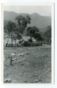
These photographs were taken just after the McKillop's Bridge was completed after the flood damage. The current McKillop’s Bridge was built by the Country Roads Board in two stages between 1931-36, during which its height was raised after the original bridge superstructure was washed away in record floods of January 1934, prior to its original official opening. In its reconstructed form the original concrete abutments were turned into additional piers and the welded-steel trusses were cantilevered back over them to meet the new higher road approaches. It is sited at McKillops Crossing, named after pioneer overlanding squatter George McKillop who crossed here in 1835. This was a stock crossing place for almost a century before the bridge was constructed. (info. from Victoria Heritage Register)This is a pictorial record of the history of McKillop's Bridge, in itself of historical significance for its association with Victoria's long and important pastoral history, its technicl significance and aesthetic significance.Three black / white photographs. 3133.1 shows the approach to a washed away bridge. 3133.2 is of a bridge over a river with men clearing debris. 3133.3 is a close-up showing the wreckage of the bridge.mckillop's-bridge snowy-river flood-damage-1934 -
 Orbost & District Historical Society
black and white photographs, 25.11.1976
These photographs were taken on November 25, 1976 at the official opening of the current Snowy River road bridge. Included in the photographs are: John Duggan; Pat Hall, C.R.B. chairman, R.E.V. Donaldson (3240.7) and J.A.Rafferty, the state minister for Transport, who cut the ribbon (3240.8). Di Young and Cheryl Dusting (3240.9) distributed souvenir information pamphlets to official guests. The Snowy River road bridge is one of four built as part of the 8.4 km project spanning the Orbost flood plains. The Snowy River bridge and another over the nearby Ashbys Gulch are among the 10 longest bridges in Victoria, being the eighth and fifth longest respectively. The new bridge removed through traffic from Orbost township crossing the Snowy River 45 m downstream of the old bridge.This bridge is the fourth to provide a crossing to the township of Orbost. (info from CRB NEWS No. 34. DECEMBER, 1976) These photographs are pictorial records of a significant event in Orbost's history.Eleven black / white photographs all related to the official opening of the current Snowy River Bridge. Details are in catalogue folder.snowy-river-bridge -
 Orbost & District Historical Society
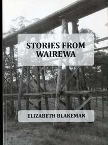
Book, Stories From Wairewa, 2017
This book is a social history collected orally and from the private records of residents of the Wairewa Valley, Victoria, Australia. It includes a brief history of the old primary school. Appended is a performance piece 'Waltz for Wairewa", a dialogue with poems and songs. It was sponsored by the Hospital Creek Bush Band and Dance Group. The book was partly the result of two song writing courses, one run on-line for six weeksby Sheffield University, U.K., and another year-long course at U3A in Lakes Entrance, East Gippsland. The bridge pictured on the front cover is O'Grady's railway bridge which was severely damaged in the bushfires of January 2020.This item is a useful reference on the history of the Wairewa Valley, East Gippsland.A soft covered book, titled "Stories From Wairewa". On the front cover is a tall wooden rail bridge. the book contains stories, photographs, scanned documents, shet music, drawings and poetry. book-wairewa blakeman-elizabeth school-wairewa -
 Orbost & District Historical Society
book, Vic Roads Centenary 1913 -2013, 2013
The publication, VicRoads Centenary: Keeping Victorians Connected for 100 Years, looks at the people and projects that define VicRoads’ history. Written by current and former VicRoads’ employees, the publication details the organisation’s portfolio of major projects, which includes the Great Ocean Road, Hume Highway and Eastern Freeway. Other sections report on Victoria’s world-first road safety initiatives, VicRoads’ use of technology and sustainability measures. (ref VicRoads) This item is one of several books donated by David Jellie at a presentation to Orbost Historical Society. He was a contributor to the book and was the engineer for the Snowy River Bridge (Princes Highway) at Orbost 1974-1976.This book is a useful reference tool on the history of road construction in Victoria including East Gippsland.A thick, bound paperback book, titled "VicRoads Centenary Keeping Victorians Connected for 100 Years". On the front cover is a black/white photograph of two men working on a road. One has a pick. The book contains the history of VicRoads, photographs, maps and advertisements. Some are b/w. Others are coloured.vicroads book roads snowy-river-bridge jellie-david -
 Orbost & District Historical Society
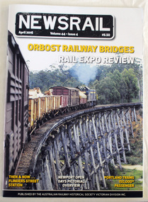
magazine, NEWSRAIL Vol 44 Issue 4 April 2016, April 2016
Established in 1945, the Australian Railway Historical Society Victorian Division Inc. has a proud history of over 70 years of catering for all who have an interest in the railway history of Victoria. It has a membership of over 500 members throughout Australia and overseas. This item was donated at the Centenary of the Orbost - Bairnsdale Railway exhibition held in Orbost April 2016. This item is a record of the the history of the Orbost-Bairnsdale railway line and therefore reflects the role that the rail line played in the social and economic history of Orbost. A magazine/booklet titled, NEWSRAIL. It is Vol. 44 Issue 4 dated April, 2016. There is an article on 'Orbost Railway Bridges. The magazine has a cost of $9.50. On the front cover is a coloured photograph of a train passing over the Wairewa trestle bridge on the Bairnsdale - Orbost line. -
 Marysville & District Historical Society
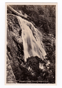
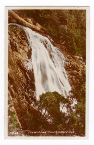
Photograph (item) - Black and white photograph, Valentine Publishing Co. Pty. Ltd, No.2. Stevensons Falls, Marysville, 1923-1963
A black and white photograph of Steavenson Falls, Marysville, Victoria.A black and white photograph of Steavenson Falls, Marysville, Victoria. The Steavenson Falls is named after the Victorian Assistant Commissioner of Roads and Bridges, John Steavenson who arrived in Victoria in the early 1860s. At 84 metres high, Steavenson Falls is Victoria's tallest cascading waterfall. The falls are split into roughly five cascades, with the last of these plunging into a small, picturesque rock pool. This photograph was published by the Valentine Publishing Co Pty. Ltd. as a souvenir of Marysville.stevenson falls, steavenson's falls, marysville, john steavenson, victoria, history, valentine publishing co, souvenir -
 Marysville & District Historical Society
Photograph (item) - Colour photograph, Valentine Publishing Co. Pty. Ltd, No.13. Stevensons Falls, Marysville, 1923-1963
An early colour tinted photograph of Steavenson Falls in Marysville in Victoria.An early colour tinted photograph of Steavenson Falls in Marysville in Victoria. The Steavenson Falls is named after the Victorian Assistant Commissioner of Roads and Bridges, John Steavenson who arrived in Victoria in the early 1860s. This photograph was published by the Valentine Publishing Co Pty. Ltd. as a souvenir of Marysville.stevenson falls, steavenson's falls, marysville, john steavenson, victoria, history, valentine publishing co, souvenir -
 Marysville & District Historical Society
Booklet - Information booklet, Ann Thomas, Wilks Creek Bridge, 1993
A history of the Wilks Creek Bridge and its connection to the Yarra Track.Paperback. Front cover has an old photograph of the Wilks Creek Bridge.non-fictionA history of the Wilks Creek Bridge and its connection to the Yarra Track.wilks creek bridge, yarra track, narbethong, marysville, victoria, clement wilks, wood's point goldfields, jordan goldfields, john monash, monash and anderson, 2009 black saturday bushfires -
Glen Eira Historical Society
Article - MONASH, JOHN, SIR
This file contains three items concerning Sir John Monash. 1/A two-page letter distributed at a rare book week event on the 22/07/2014 to the Glen Eira Historical Society from Michael Headberry. The letter requests support for the John Monash Sculptural Commission by the Monash Pioneers, who are seeking to erect a bronze full figure portrait of Sir John Monash, Monash University’s namesake. Monash is connected to the city of Glen Eira, as Monash University has a campus in Caulfield and there are a number of streets named after him. The letter discusses the life of Monash and his many achievements. Details in another two pages are also given of the statue to be erected and there are two photos of a wax model of the proposed statue; plus a donation form. 2/An article by Dana McCauley dated 17/05/2015 entitled ‘Push to rename Ports’ about Caulfield lawyer and Liberal Kate Ashmor. The article discusses how she wants the electorate of Melbourne Ports to be named after Sir John Monash due to him being one of the most prominent Victorian Jews. There is a photo of Ashmor in fron of a statue of Monash. Newspaper not known. 3/An article from the Leader on the 30/06/2015 entitled ‘Exhibit’s unique view on Jews in WW1’. The author is unknown. The article discusses an exhibition at the Jewish Museum of Australia about the social history behind the Jewish support of the war effort. One item included in the exhibition is Isaac Cohen’s painting of Lieutenant General Sir John Monash and there is a photograph, by Andrew Henshaw, of this work above the article.monash university, monash john sir, caulfield, sir john monash, sculptural commission, clubs and associations, monash pioneers, correspondence, fundraising, universities, statues, armed forces, engineers, languages, art, pianos, diaries and journals, jewish community, world war 1914-1918, businesspeople, corlett peter, artists, sculptors, headberry michael, monash pioneers, project board, portraits, models, bridges, returned sailors and soldiers imperial league, ex-service organisations, st. kilda, leader, jewish museum of australia, rechter deborah, cohen isaac, ‘lieutenant general sir john monash’, portraits, national gallery of victoria, henshaw andrew, ‘true jews and patriots: australian jews and world war one’, shows and exhibitions, social history, ‘exhibit’s unique view of jews in wwi’, caulfield, ‘push to rename ports’, mccauley dana, political candidates, australian liberal party, ashmor kate, electoral boundaries, local government -
 Flagstaff Hill Maritime Museum and Village
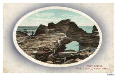
Postcard - Scenic, Warrnambool, Titan Bridge, Shelly Beach, Warrnambool, 1902-1929
The nine postcards in this set were donated together and date to the early 1900s. All but one postcard in this set shows images of Warrnambool, in the Western District of Victoria; the other has a London image. The postcards were all printed in Great Britain according to that country’s postal regulations. The fronts of all cards have titles printed in red. Most of the images on the cards are attributed to photographer Joseph Jordan and belong to the Jordan Series. The back of these cards has an outline for a postage stamp, a vertical dividing line and a heading on each side of the line to separate the Correspondence from the Address. Postcards or ‘correspondence cards’ appeared in Britain in 1894. They were plain cards with a space for the message on one side and an address on the other; regulations didn’t allow anything but the address to be written on the ‘address’ side. In 1902 the British regulations then allowed a picture to be printed on the front and the address on the back, so messages had to be written on the picture side. Soon, the regulations changed and the back was divided for a message and the address. Titan Bridge, Warrnambool – The name Titan Bridge is likely to be a reference to the huge Titan crane that was used in the construction of the Breakwater in the late 19th century. Shelly Beach is a popular swimming area with the added attraction of rock pools to investigate and rock formations to climb. Joseph Jordan - Joseph Jordan was born in 1841 in Leicester England. When he was 16 he joined the 7th Queen's Own Hussars and was sent to India at the outbreak of the mutiny. He took part in the relief of Lucknow and remained in India for eleven years. It was during this time that he became interested in photography. He was posted to New Zealand and later came to Victoria, becoming a sergeant major of the Mounted Rifles. In the mid-1880s he came to the Western district where he was responsible for establishing units of the Mounted Rifles in various country towns such as Dunkeld, Mortlake, Panmure, Bushfield, Koroit etc. He resigned from the army in 1889 and set up a professional photography studio in Liebig Street, Warrnambool. He became very well known in the Western District for family photographs, official photographs of local councillors and groups as well as views of local scenery. In 1891 he photographed the wrecked barque ‘Fiji’ at ‘Wrecks Beach’ near Princetown. His business was taken over by his son Arthur around 1917. Joseph was a keen rifle shot and in 1924 he donated the "Jordan Shield" as a prize to the Victorian Rifle Association. He was made a "Life Honorary Member" of the Warrnambool Returned Soldiers League and in 1933 he was recognised as being the oldest living soldier in Victoria. Joseph died in 1935 aged 95.The image of the Titan Bridge rock formation with figures on it suggests that the location was a popular place to visit. It captures a time when the rock formation was publically accessible. The choice of subject for this postcard indicates the popularity of Warrnambool's natural environment as a tourist attraction at a time when ships called coastal traders brought passengers and cargo to the Port of Warrnambool from ports along Victoria's southwest coast. Joseph Jordan is a significant figure in Warrnambool history as he helped to establish early units of the Mounted Rifles (G Company) in local towns during the late 1880's and later, photographed local scenes, groups and citizens of early Warrnambool.Postcard, one of nine, landscape orientation, coloured print within an oval border and mauve-toned shading. The cameo image shows two figures, one seated and one standing, beside the sea on a rough rock beside a rock formation resembling a bridge. There is no correspondence written on the card. The back has inscriptions and outlines for a postage stamp. Jordan Series, printed in Great Britain.Front, in red: “TITAN BRIDGE / SHELLY BEACH, NEAR WARRNAMBOOL” Back in black: “Jordan Series” “POST CARD” “PRINTED IN GREAT BRITAIN” “For correspondence” “The Address only to be written here”flagstaff hill maritime museum, flagstaff hill maritime village, flagstaff hill maritime museum and village, maritime museum, warrnambool, great ocean road, warrnambool and district, warrnambool scenes, local scenes, views of warrnambool, joseph jordan, jordan series, jordan photography, postcard, souvenir, correspondence, cameo postcard, landscape, shelly beach, titan bridge, titan, rock formation -
 Federation University Historical Collection
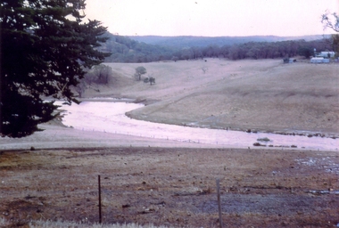
Photograph - Colour, Leigh River near Garibaldi Bridge
The Leigh River is a major tributary and catchment of the Barwon River. Fed by the Yarrowee River that rises near Ballarat, the Yarrowee reaches its confluence to form the Leigh in the vicinity of Cambrian Hill and Golden Plains Shire. The Leigh River rises below Mount Mercer and flows generally south, joined by three minor tributaries before reaching its confluence with the Barwon River, southeast of the central business district of Inverleigh. The river descends 265 metres (869 ft) over its 61-kilometre (38 mi) course. (https://en.wikipedia.org/wiki/Leigh_River_(Victoria)Relates to historical information about flooding of the Leigh River in 1933. Relevant to the history of Garibaldi and Durham Lead.A number of colour photographs showing the Leigh River between Garibaldi and Durham Lead, Victoria, .1 - .3) photographs of the Leigh River in flood .4 - .18) general photos of the Leigh River and surrounding countryside .19) broad angle photograph of the Leigh River and surrounding countryside leigh river, garibaldi, garibaldi bridge, durham lead, vincent family -
Federation University Historical Collection
Document, Walter Martin of Garibaldi, Victoria, c2015
Walter Martin was born on 25 August 1915, and died on 07 October 1995. He was raised on the family property of Garibaldi which was opposite the Garibaldi Bridge, and attended the Garibaldi State School until 1930. At the time of Walter Martin's retirement the family property had been in the family for 130 years. He was a keen photographer and combined this passion with a knowledge of the history of Garibaldi and Durham Lead. Walter Martin was an engineering blacksmith at Durham Lead and lived at 'Cragleigh' RSD R-885, Durham Lead, 3352.Nine typed pages relating to Walter Martin, including copies of photographs. It includes a copy of a reference from the Buninyong Shire Council.walter martin, blacksmith, garibaldi, durham lead, elaine, garibaldi bridge -
Federation University Historical Collection
Book, Historic Sites Survey: North Central Study Area, 1979, 1979
The North Central Study Area included the Shires of Avoca, Bet Bet, east Loddon, Goulburn, Untly, Kara Kara, Korong, Maldon, Marong, Metcalfe, McIvor, Newstead, Strathfieldsaye, Stawell, Talbot, Clunes, Tullaroop and Waranga. 153 page book with white plastic binding. It is an historic sites survey for the North Central Study Area commissioned by the Land Conservation Council, the Ministry for COnservation and the Australian Heritage Commission. castlemaine, mount alexander goldfield, maldon, percydale, warrenmang, moliagul, tarnagulla, stuart mill, the whipstick, whroo, rushworth, graytown ironbark forest, st arnoaud, new bendigo, landsborough, inglewood, kurting, wedderburn, wehla, kooroora, langham flat, mcintyre, rheola, diamond hill, fosterville, coliban water works, green gully, newstead, muckleford forest, costerfield, graytown, bailieston, waranga irrigaiton system, eucalyptus distillery, mia mia bridge, korokubeal township researce, concegella slate quarry, chewton, fryerstown, kingower, timor, talbot, majorca, carisbroook, clunes, st arnaud, taradale, icomos, dunolly, limestone, castlemaine slate quarry, harcourt granite, taradale railway viaduct, loddon united waterworks trust, gouldburn weir, carisbrook lock-up, history of tree planting in streets, history of public reserves, r.u. nicholls nurseryman, thomas lang, francis moss, ballarat botanical gardens, ballarat school of mines botanical gardens, lake wendouree, victoria park, ballarat, muont holled smith, ballaarat old cemetery planting, eastern oval, ballarat east botanical gardens, ballarat east town hall gardens, eureka stockade reserve, ballarat observatory plantings, yarrowee creek plantings, yarrowee bluestone channels, ballarat woollen mill, band and albion mullock heap, black hill plantings, yarrowee creek channels, canadian creek channel, specimen vale channel, poverty point reserve, union jack reserve buninyong, imperial mine, buninyong, victoria street plantings, bridge mall, sturt street gardens, ballarat avenue of honour plantings, white flat oval plantings, camp street, elms, burnt creek -
 Flagstaff Hill Maritime Museum and Village
Document - Navigation Chart, Admiralty Office, Lady Bay and Warrnambool Harbour, 1893
This navigation cart of Lady Bay and Warrnambool Harbour was originally surveyed in 1870 but this version includes the update for magnetic variation in 1893. Since the printing of the chart several annotations have been added. These include an additional stamp dated 15-8-1910, a handwritten comment across the top of the page dated August 1910, and another handwritten comment regarding the ‘Proposed Extension of Dock’ dated 19-2-1925, plus connected drawings, notes and figures. The 1925 proposal on this chart may have been a reaction to the Royal Commission of 1923, when the damaged stonework on the seaward side of the Warrnambool Breakwater, caused by the action of the sea, was the subject of enquiry. A conference between the Public Works, Water Commission and the Harbour Trust concluded that it would less costly to make repairs to prevent further damage rather than replaced the damage portion of the wall. A contract was raised in late 1924 to deposit rubble on the damaged side of the breakwater to minimise the Southern Ocean’s destructive action and work had started by August 1925. The Breakwater construction had begun in 1874 and was completed in 1890. The Victorian Government had commissioned Sir John Coode, a British harbour engineer, to present a plan to complete the Warrnambool Breakwater but his original plan was too expensive. He prepared a revised plan for a shorter structure. The construction proved to be too short to protect adequately from the weather and didn't allow enough depth for larger vessels to come into port. The decreasing trade was further affected by siltation in the bay due to the breakwater, and the completion of the railway line. The situation of the harbour became a real problem by 1910 and required continuous dredging. In 1914 the Breakwater was extended but proved to be a failure because the work began to subside and by 1920 about two thirds of the harbour was silted up. Alterations made in the 1920's increased the silting problem and by the 1940's the harbour was no longer used. More alterations were made in the 1950's and 1960's. This chart is significant for its strong connection to the maritime history of Warrnambool Harbour and Lady Bay and the Warrnambool Breakwater. The Warrnambool Breakwater is registered as a place of significance on the Victorian Heritage Database (VHR H2024). The Warrnambool Breakwater is one of the most important late 19th century maritime engineering projects in Victoria and significant in the development of Victorian coastal shipping. It is also significant for its connection with British harbour engineer, Sir John Coode. The chart is a historical record of structures existing in 1893; the Warrnambool Jetties, Warrnambool Breakwater in Lady Bay, the leading lights (lighthouses), streets, roads, bridges and many buildings. It also shows the lay of the land and seabed. Navigation Chart: Lady Bay and Warrnambool Harbour, Australia - South Coast - Victoria. Surveyed by Nav. Lieut. H.J. Stanley, R.N., 1870. Updated for Magnetic Variation, 1893. The rectangular chart is printed on heavy cream paper. Stamps are shaped rectangular, oval and round. Around the Breakwater and Jetty area are handwritten notes, dotted and joined lines, numbers and signatures, and shading of red and green. The chart shows the surrounds of Warrnambool Harbour, Lady Bay, the Breakwater and Jetty, roads, bridges and the streets in Warrnambool. It has sounding details, and angles of line from the leading lights.Stamp, rectangular, including "AUG 1910" Stamp, double oval " - - - -CHART" Stamp, hand drawn, red circle, with "B" inside Hand written note "22-8-1910 - - - - - of surveying C. Ca - - - request of 15-8-10 [initials] " Notes and lines in red pen, including a grid of sounding numbers: "1300" "1050" "1200" "Possible Extension of Dock" "19-2-25" "Dock Dredged to 20 Ft" Notes and lines in blue pen "Extension of Dock to accommodate vessels drawing 20 Feet" and "Light not visible south of this line" Red dots (4) with yellow highlight at both leading lights, breakwater and jettyflagstaff hill, warrnambool, flagstaff hill maritime museum & village, maritime museum, maritime village, shipwreck coast, map, chart, navigation chart, plan, lady bay, warrnambool harbour, port of warrnambool, breakwater, jetty, pier, dock extension, proposed extension, vhr h2024, 1870, 1893, 1910, 1925, warrnambool town late 1800s, warrnambool streets late 1800s royal commission, 1923, public works, water commission, harbour trust, victorian harbours, sir jon coode -
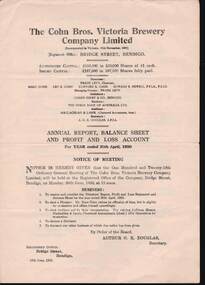
 Bendigo Historical Society Inc.
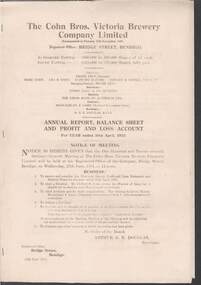
Document - COHN BROTHERS COLLECTION: VICTORIA BREWERY COMPANY LIMITED ANNUAL REPORT 30 APRIL 1951
The Cohn Bros. Victoria Brewery Company Limited Annual Report, Balance Sheet and Profit and Loss Account for Year ended 30 April, 1951. Registered Office : Bridge Street, Bendigo. Printed document, stapled, five pages in length. Directors : Frank Levy (Chairman and Managing Director), Marc Cohn, Leo R. Cohn, Clifford Cohn, Edward B. Newell. Secretary : Arthur G. K. Douglas.bendigo, industry, cohn bros., cohn bros. victoria brewery company limited. -
 Bendigo Historical Society Inc.
Document - COHN BROTHERS COLLECTION: VICTORIA BREWERY COMPANY LIMITED ANNUAL REPORT 30 APRIL 1950
The Cohn Bros. Victoria Brewery Company Limited Annual Report, Balance Sheet and Profit and Loss Account for Year ended 30 April, 1950. Registered Office : Bridge Street, Bendigo. Printed document four pages in length. Directors : Frank Levy (Chairman and Managing Director), Marc Cohn, Leo R. Cohn, Clifford Cohn, Edward B. Newell. Secretary : Arthur G. K. Douglas.bendigo, industry, cohn bros., cohn bros. victoria brewery company.