Showing 273 items
matching campus map
-
 Federation University Historical Collection
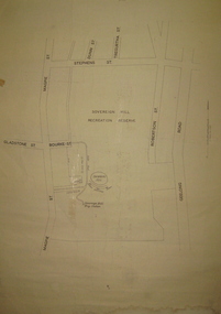
Plan, Sovereign Hill Recreation Reserve and Surrounds
This map was probably produced around the time that the Sovereign Hill Museums Association was established. A simple plan with black marking on paper. It shows the Sovereign Hill Recreation Rerserve, including the swimming pool located near the Sovereign Hill Trig Point, showers, toilets, kiosk, bandstand and pine trees. The plan also depicts the Ballarat East streets surrounding Sovereign hill, including Geelong Road, Magpie Street, Stephens Street, Tregurtha Street, Dunn Street, Bourke Street, Gladstone Street and Robertson Street. The scale is 2 chains to 1 inch.sovereign hill, swimming pool -
 Federation University Historical Collection
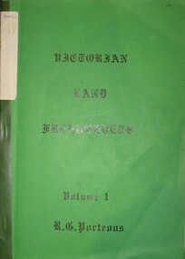
Book, Roger G. Porteous, Victorian Land Freeholders
Green soft covered book with green tape spine. The book includes names and dates of the first land freeholders listed on Ballaarat and district Parish Maps. -
 Federation University Historical Collection
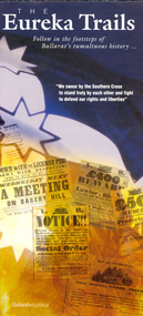
Brochure, The Eureka Trails, c2005
The brochure gives information on the Eureka Stockade which took place on 03 December 1854.Double sided A3 brochure with colour reproductions of scenes related to the Eureka Stockade. The brochure includes a map showing the route the Government forces took on their way to the Eureka Stockade as well as sites of interest to Eureka. eureka, eureka stockade, diggers' trail, trooper's trail -
 Federation University Historical Collection
Plan - Plan (copy), Melbourne Road Ballaarat, 1857
This map shows the vicinity of the site of the Eureka Stockade. A3 black and whole photocopy of a plan of Ballarat's Melbourne Road. The plan shows Melbourne Road, Proposed Melbourne Road (later Eureka Street), Chamberlain Street, Queen Street, Allotments between Rodier Street and Stawell Street (William Collard Smith, J & T Oddie, F.A. Edward A. Wynne, David Fitzpatrick, Robert Walsh, Charles Spencer, Alfred Lester, Free Trade Hotel)william collard smith, oddie, wynne, fitzpatrick, walsh, spencer, lester, free trade hotel -
 Federation University Historical Collection
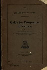
Book, Guide for Prospectors in Victoria, 1931, 1931
The handbook was intended for those with little experience who wanted to prospect of fossick.Grey soft covered book of 90 pages. Includes fold out map of a portion of Victoria showing auriferous areas and mineral localities. Also show Counties of Victoria and localities of minerals such as tin, antimony, copper, silver lead, Malybdenite, tungsten ores, manganese, platinum, osmiridium and iron. Chapter heading s include: working alluvial deposits, equipment, geology of Victoria, gold deposits, quartz reefs, indicators, economic minerals, assistance to prospectors, Miners' Right, mining bye-law, mining leases, forest regulations and glossary. Descriptions are given of a god dish, puddling tub, cradle, puddling machine, ground sluicing, boring, windlass, whim, hand dollying, sweeping, California pump, and wing dam.mining, baragwanath, gold, prospector, geology, quartz reefs, alluvial deposits, indicators, victorian goldfields, miners rights, mining leases, forest regulations, sluicing, sluice box, puddling machine, miner's cradle, whim, whip, california pump, gold nuggets, saddle reef, ballarat indicators, state batteries -
 Federation University Historical Collection
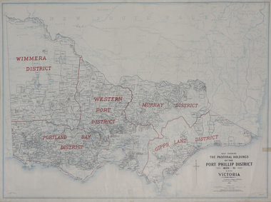
Plan, Map Showing the Pastoral Holdings of the Port Phillip District 1835-1851 Now Victoria, 1932, 1932
Another name for Pastoral Holdings is squatting runs. Information on Alfred Stephen Kenyon of the Historical Society of Victoria can be found at http://adb.anu.edu.au/biography/kenyon-alfred-stephen-6936/text12035 Map of Victoria showing the boundaries of the Port Phillip District (Victoria) pastoral boundaries. pastoral holdings, squatters, squatting, victoria, land, crown lands, a.s. kenyon, alfred stephen kenyon -
Federation University Historical Collection
Plan (copy), Frederick Proeschel, Map of the Roads to all the Gold Mines in Victoria, 1853
The map was pirated from Frederick Proeschel's "Pocket Map of the Roads to all the Gold Mines in Victoria" issued earlier in 1853.Digital file of the Map of the Roads to all the Gold Mines in Victoria. The map has been coloured to show routes to the Victorian goldfields from Melbourne and Geelong.frederick proeschel, proeschel, gold, mining, philp -
 Federation University Historical Collection
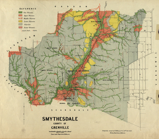
Map, Smythesdale, County of Grenville, 1888, 1889
The map maker, Ferdinand M. Krause, was a professor at the Ballarat School of Mines. This land was printed form the Crown Lands Department, Melbourne. Coloured map of the County of Grenville. The edge has been taped. The scale is 40 chains to 1 inch. The map is accompanied with a foolscap sheet printed by the Mines Department in 1898. It is a Report on the Parish of Smythesdale by F.M. Krause and includes information on the water reserve, worked quartz veins, Watson's Hill, Surface Hill and Sugarloaf Hill, Haddon, Trunk Lead and the Crucible Shaft. smythesdale, krause, f.m. krause, ferdinand krause, nitingbool, watson's hill, surface hill, sugarloaf hill, haddon -
 Federation University Historical Collection
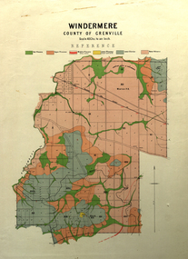
Map, Windermere, County of Grenville
Coloured geological map of Windermere, County of Grenville. Scale is 40 chains to 1 inchwindermere, grenville, krause, plan, map -
 Federation University Historical Collection
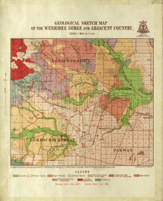
Map, Geological Sketch Map of the Werribee Gorge and Adjacent Country, 1914, 1914
A coloured geological sketch map of the Werribee Gorge, Bacchus Marsh, Rowlesy, Darley, Parwan. The scale is 1 mile to 1 inchwerribee gorge, bacchus marsh, darley, parwan, w.e. bennett, bennett, r.a.f. murray, c.c. brittlebank, rowsley -
 Federation University Historical Collection
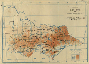
Map, Victoria: Regions for Planning and Development, 1944, 1944
This map was produced for the State Regional Boundaries Committee Two colour map of Victoria showing the regions for planning and development. The regions are Central Highlands, Mallee, Wimmera, Glenelg, Corangamite, Barwon, Loddon, Goulburn, Upper Goulburn, Upper Murray, East Gippsland, West Gippsland, Port Phillip.central highlands, mallee, wimmera, glenelg, corangamite, barwon, loddon, goulburn, upper goulburn, upper murray, east gippsland, west gippsland, port phillip, victoria, m4486 -
 Federation University Historical Collection
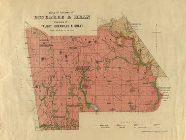
Plan, Bungaree and Dean Parish and Geological Plan, 1890, 07/1890
Ferdinand M. Krause was a Professor at the Ballarat School of Mines.Geological and Parish Map of parts of the Parishes of Bungaree and Dean in the Counties of Talbot, Grenville and Grant. The scale is 40 chains to one inch. bungaree, deen, krause, f.m. krause, musk creek, clarkes hill, badger hill, beale's reservoir, acquainted. -
 Federation University Historical Collection
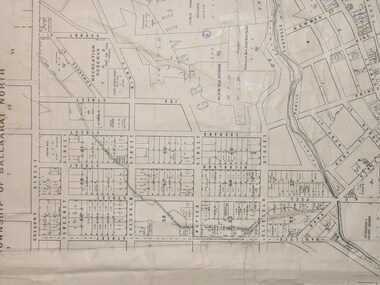
Map, Municipality of Ballarat East, 1857
Gold was discovered in Ballarat in 1851. This plan was created six years later and names some of the great gold locations of Ballarat East. It also shows the locality of the Eureka Stockade (1854) and the walking tracks and roads on the Ballarat East Goldfield.In 2007 this map was listed on the inaugural Ballarat Treasure's Register.Large map backed onto linen. The map has read and blue highlights, and identifies areas such as Mount Pleasant, Golden Point, White Flat, Nightingale, Malekoff, Old Post Office Hill, Red streak, Gumtree Flat, Old Gravelpits, Bakery Hill, Ballaarat Flat, The Camp, Specimen Gully, Pennyweight Hill, Warrenheip Gully, Gays Gully, Pennyweight Flat, Eureka, Black Hill, Pinchgut, Crocodile, Hit or Miss, Little Bendigo, Brown Hill, Mopoke, Cricket Reserve, Canadian Hotel, Ballarat Eastmount pleasant, golden point, white flat, nightingale, malekoff, old post office hill, red streak, gumtree flat, old gravelpits, bakery hill, ballaarat flat, the camp, specimen gully, pennyweight hill, warrenheip gully, gays gully, pennyweight flat, eureka, black hill, pinchgut, crocodile, hit or miss, little bendigo, brown hill, mopoke, cricket reserve, canadian hotel, ballarat eastm phillips, john phillips, field draughtsman, ballarat east, ballarat east map -
 Federation University Historical Collection
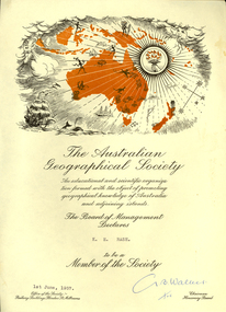
Certificate, Australian Geographical Society, Australian Geographical Society certificate made out to Keith Rash, 1957, 01/06/1957
Certificate of the Australian Geographical Society made out to Keith Rash. One printed page, map of Oceania including sailing ship, torch, map of Australia and surrounding islands. G. B. Walker (signature)rash, keith rash, australian geographical society, g.b. walker -
 Federation University Historical Collection
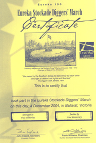
Certificate, Eureka Stockade Diggers' March Certificate, 2004
2004 was the 150th anniversary of the Eureka Stockade. The 'Eureka Stockade Diggers' March' was part of the 150th anniversary. The certificate was collected by Kathleen Gervasoni, Great Grand-daughter of Michael O'Dea who was associated with those at Eureka in 1854.Yellow card certificate with blue writing. The front features an image of Charles Doudiet's 'Swearing Allegiance to the Southern Cross', and the recerse shows a map of the 2004 Diggers' March Route and a facsimile of a gold license. The Certificate was signed by John Ireland (Eureka's Children) and Frank Williams (Eureka Stockade Memorial Association)eureka, eureka stockade, eureka rebellion, eureka aniversary, eureka 150, john ireland, frank williams, eureka stockade memorial association, eurekas childrenn -
 Federation University Historical Collection
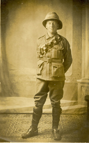
Postcard, Harold Reid, c1916
Harold Reid, dressed in Australian Army uniform poses for a photograph during World War One. Verso 'Harold Reid, taken at place where we have our maps printed.'chatham family archive, chatham, holmes, world war, world war 1, world war i, world war one, france, harold reid, reid -
 Federation University Historical Collection
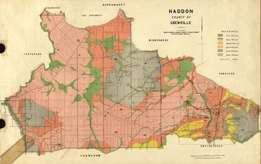
Plan, Haddon, County of Grenville, 1887, 1889
Ferdinand Krause taught at the Ballarat School of MinesGeological Map of Haddon in the County of Grenville surveyed by Ferdinand Krause. haddon, grenville, krause, ferdinand krause, cgt, lake burrumbeet, windermere, chepstowe, bailies creek, snake valley lead, nentingbool preemptice right, cardigan state forest, haddon state forest -
 Federation University Historical Collection
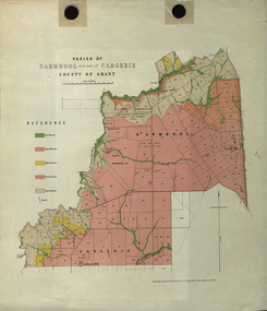
Plan - Map, Mines Department, Parish of Narmbool and part of Cargerie, County of Grant, 1892, 06/1992
This map shows the position of the homestead on the Narmbool Pre-emptive Right, volcanic craters, stock reserve, quarry and geological eras,Geological map showing Narmbool and part of Cargerie in the County of Grant in five colours, predominantly pink.narmbool, cargerie, narmbool pre-emptive right, williamson's creek, leigh river, green hill, collyer's hill, volcano, crater, krause, ferdinand krause -
 Federation University Historical Collection
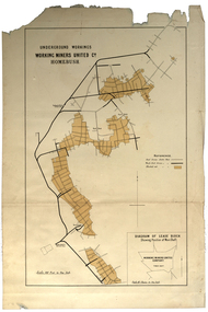
Plan, Underground Workings, Working Miners United Co. Homebush
Printed map on paper various measurements and locationsunderground workings, plan, working miners united co, homebush -
 Federation University Historical Collection
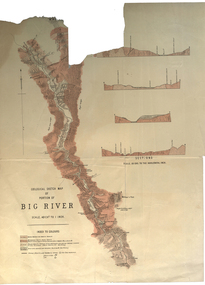
Plan, Geological Sketch Map of Portion of Big River
Printed map on paperscale, index to colours, sectionsgeological sketch map, plan, big river, mount wills, geology -
 Federation University Historical Collection
Map, Ballarat and Sebastapol Gold Mines, Late 19th Century
colored printed map on paper lined onto linen backingprinted "Rider & Mercer's Plan of the Ballarat & Sebastapol Gold Mines Scale 30 Chains to One Inch"gold mines, mine allotment map, mining leases, ballarat, sebastopol, rider and mercer, golden shaft co, prince of wales and bonshaw united, leviathan gold mines, holst and co, speedwell co, sebastopol plateau, rothschild co, tower hill co, south plateau, south star co, band of hop and albion consols, prince regent co, chenhall and co, despza, buninyong estate, one eye hully, winter's freehold, luplau plateau, e. morey, carrill's quartz -
 Federation University Historical Collection
Document, Ken Clements, Peterborough Puzzles, 2009, 2009
Massacre Bay is located on Victoria's Great Ocean Road, and is in the centre of the Bay of Martyrs. The bay consists of 20 m high, red limestone bluffs. This paper by Ken Clements considers the origin of the term martyr in connection to this location, and where the Aboriginal massacre may have taken place. Thirteen page document by Ken Clements relating to Peterborough, Victoria. Contents include coastal features, local Aborigines, Bay of Martyrs, Massacre Bay, Massacre Hill, Buckley Creek Run, Pioneer Pastoralists, British Traversers, settlers, Peterborough, Maps, tourism, history method. Photographs by Laurie Moore.aborigines, bay of martyrs, massacre bay, massacre hill, buckley creek run, pioneer pastoralists, british traversers, settlers, peterborough, maps, tourism, history method, childers cove, barque children, murnane bay, sandy bay, dog trap bay, buckley creek, viviennes lookeout, stanhope bay, buttres bay, burnies beach, armstrong creek, flaxman hill, antares rock, lovers nook, crofts bay, clements, worm bay, halladale point, the well, wold dog cove, james irvine monument, curdies inlet, squirrel creek, wallaby creek, boggy creek, whiskey creek, pioneer beach, schomberg rock, young australia, spit, crown of thorns, newfield bay, the grotto, london bridge, point hesse, high cliffs, the arch, cape martyr, little massacre bay, aboriginal massacre, ken clements -
 Federation University Historical Collection
Book, Memoirs of the Geological Survey of Victoria No 14 The Ballarat Goldfields, 1923, 1923
William Baragwanath was educated at the Ballarat School of Mines, obtaining a Geology Certificate in 1911. After further study he went on the become Secretary for Mines, and Chief Mining Surveyor. Baragwanath was a Councillor of the Ballarat School of Mine from 1916 to 1950.Pink covered foolscap book of 257 pages and 32 maps and plans by William Baragwanath. Contents include topography, physiography, historical, geology, basalt, faults, dykes, minerals leads, alluvial mines, nuggets, structure of Ballarat West goldfields, structure of Ballarat East gold-field, quartz formation, indicators, defunct mines, existing mines, table of deepest shafts. Images include: section of the Ballarat Gold-Field, Dead HOrse Flat, lakes formed by Basalt Flows, Gong Gong Creek, Frenchman's Lead, Ballarat West Mines, LEases and positions of shafts (1857), puddling, White Horse Lead, Woah Hawp Canton, Ballarat Township mines, Sebastopol, syncline, Victoria United Line, First Chance Mine, Llanberris No 1 Mine, Saddle Reef, New Normanby Mine, Woah Hawp Canton Mine, South Star Mine, Sebastopol Plateau, south Woah Hawp Mine, Woah No. 2 Minegeology, geological survey no 14, ballarat, baragwanath, william baragwanath -
Federation University Historical Collection
Map, Topographical Map Creswick A & B
Printed map on papercreswick, clunes, lexton, waubra, smeaton -
Federation University Historical Collection
Map, Creswick Gold Field Map, 1981
A fragment of the original 1880 map is also held in the collection. See 116Rectangular geological map with brown paper strip on top edge with 4 holes on top edge. Scale is 40 chains to one inch.Geologically and topographically surveyed by Ferdinand M Krause. Lithographed by R. Shepherd. Printed by J. Finnie. Mining Department, Melbourne. Preprinted with additional shaft and lead detail. F. D. Atkinson, Government Printer 1981creswick, krause, surveyor, smeaton, spring hill, tourello, ascot, dean, bullarook, gold fields, gold -
 Federation University Historical Collection
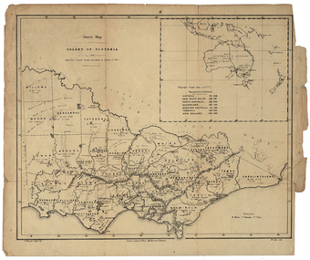
Map, Robert Brough Smyth, Sketch Map of the Colony of Victoria, c1871, c1872
This map includes the population of each County in Victoria according to the 1871 Census, as well as the population of each Australian colony and New Zealand. Telegraph Route is given in a detail at the top right. victoria, victorian counties, robert brough-smyth, telegraph, population, bourke, rodney, dalhousie, evelyn, mornington, buln-buln, tanjil, dargo, delatite, moira, bogong, bendigo, gunbower, grant, talbot, hampden, heytesbury, polwarth, ripon, kara-kara, gladstone, grenville, croajingolong, tambo, benambra -
 Federation University Historical Collection
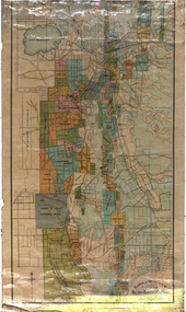
Plan, City of Ballarat (Part) (Ballaarat East), 08/05/1928
Crown Cadastral Plan showing Governement Roads, Crown Parcels, Dimensions, Crown grantees, dated of grants, etc in Ballarat East. The plan shows features such as Bakery Hill, Canadian Station, recreation reserves, timber reserves, Yarrowee Creek, Black Hill Reserve, Eureka Reserve and Garden, Orphan Asylum, Rifle Butts Reserve, Ballarat Woollen Mill, Ballarat Observatory, Sovereign Hill Recreation Reserve, Specimen Vale, Market Reserve, Cemetery WGS 84 Centroid 37 degrees 33' 55" S 143 degrees 52' 38" E E.W. Extent; 5 km N-S Extent; 4 kmmap, plan, ballarat east, ballarat woollen mill, ballarat railway line, ballarat railway station, eureka reserve, eureka cemetery, ballarat orphanage, russell square, bakery hill -
 Federation University Historical Collection
Map, Ballaarat Gold Field, 1861, 21/10/1861
A party of surveyors camped by Yuille's Swamp (later Lake Wendouree) and surveyed the countryside for a map to be produced by the Geological Survey of Victoria. In November 2004 the Central Highlands Regional Library presented a special edition of 200 copies of the 1861 map reproduced from a copy in their collection. Original geological map of Ballarat showing property, waterways, mines, churches, schools, water races, and garden reserves. It was compiled and drawn from the surveys of Mining Surveyors Davidson, Fitzpatrick and Cowan.Compiled & Drawn from the Survey of Mining Surveyors Davidson, Fitzpatrick and Cowan & the Plans in the Surveyor General's Office by J. Brahe, 21st October 1861. R. Brough Smyth, Secretary for Mines. The Honourable J.B. Humffray, M.L.A. Commr of Mines.ballarat, map, davidson, robert brough-smyth, fitzpatrick, cowan, yuille's swamp, public garden reserve, manure depot, black hill, ballarat east, old post office hill, pennyweight hill, claytons hill, golden point, mining, railway, cricket ground, swamp creek, cemetery, sludge reserve, bakery hill, gaelic church, juvenile reformatory, orphanage, specimen hill, eureka lead, cattle yard hill, dalton's flat, chinese village, poverty hill, railway reserve, little bendigo diggings, pound reserve, allied armies, flour mill, agricultural reserve, marsh, survey reserve, survey corps, white flat, yarrowee, yarrowee creek, brache, j. brache, survey, ballaarat gold field 1861 -
 Federation University Historical Collection
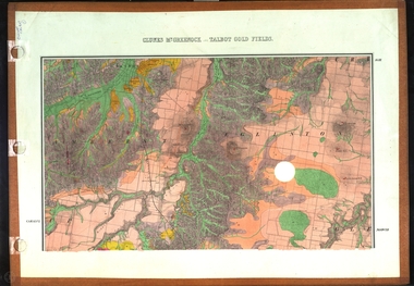
Map, Clunes, Mt Greenock, and Talbot Gold Fields, 1883, 1883
A geological plan of the Clunes, Mt Greenock, and Talbot Gold Fields in two parts. .1) This section of the map includes Talbot, Talbot water supply race, Mt Glasgow, Little Green Hill, Middle Hill, Mt Cameron, Ballarat Hill, Bakery Hill, Goodwoman Hill, Scandanavian Lead, Eglinton Swamp, McCallum's Creek, Tullaroop Creek, Dunach, Maryborough Railway, Middle Creek and includes many mines such as Rip Van Winkel, Union Extended, South Greenock, Nicholl's Freehold. .2) This section of the map includes McCallums, Clunes, Green Hill, Mt Beckworth, Mt Gap, Maryborough Reservoir, and includes mines such as Lothair, Bute, Clyde, Clunes Consols, London and Australian, Oriental,clunes, talbot, water supply, railway, geology -
 Federation University Historical Collection
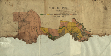
Plan, Meredith Geological Map
Coloured map of Meredith backed onto sheets of paper.meredith, borhoneyghurk pre-emptive right, borhoneyghurk east pre-emptive right