Showing 261 items
matching central board
-
 City of Moorabbin Historical Society (Operating the Box Cottage Museum)
Document, photocopy of Plan of Beaumaris 1853, c1960
Beaumaris includes two early estates in the parish of Moorabbin developed by Josiah Holloway from 1852. Named Beaumaris Town and Beaumaris Estate (after the pastoral run in the area and ultimately after Beaumaris in Wales), the lots comprising them were marketed by Mr Holloway's suggesting that the railway was imminent and a canal would be built. The township developed slowly, a Post Office opened on 1 March 1868, but was replaced next month by Gipsy Village office (now Sandringham) In 1862 Beaumaris was one of the early settler communities within the boundaries of the Moorabbin District Roads Board , the region’s first local government authority. Beaumaris is a suburb in Melbourne, Victoria, Australia, 19 km south-east from Melbourne's central business district. .Since the Amalgamation of Councils 1994 the local government area is the City of Bayside which includes Brighton. A Photocopy of the Plan of Beaumaris 1853 A3moorabbin, county of bourke, brighton, beaumaris, pioneers, early settlers. market gardeners, cheltenham, king. john, holloway josiah, whorral charles, arthur’s seat road, nepean highway, morabbin district roads board, sandringham, mordialloc, mentone -
 Glenelg Shire Council Cultural Collection
Photograph, Discharge a heavy lift for APML, Oct. 1956, on board vessel 'Ixion', 1956
Port of Portland Authority archives.Front: (no inscriptions) Back: APML - a heavy lift Oct 1959 discharged - vessel 'Ixion" (top, pencil).port of portland -
Glenelg Shire Council Cultural Collection
Photograph - Photograph - Shire of Glenelg Councillors, c. 1963
Sourced from Casterton Town Hall (Former Shire of Glenelg)Black and white photo. Three councillors for the Central Riding, Shire of Glenelg 1962/3, sitting behind desk, Honour Board on wall behind them, with names of Past Presidents of the Shire of Glenelg, 1863 - 1963 Left to right: H. D Mitchell, J.J. Howlett, J. R Hargreaves Council chambers, Casterton Town HallBack: Black stamp '003635. Letter 'A' heavy pencil. Blue biro line, arrowed each end, drawn across photo. '3" ' above line. 'Councillors central Riding 1962/3 '1/4 black' -pencil L to R Cr H.D. Mitchell Cr. JJ. Howlett Cr. J.R. Hargreaves' - handwritten pencil -
 RSL Victoria - Anzac House Reference Library and Memorabilia Collection
Photograph, Macleod Repatriation Sanitorium, circa 1914
The former Mont Park/Bundoora Psychiatric and Repatriation Hospitals Complex consisted of seven hospitals on a site of 185 hectares. The site comprising the Mont Park and Strathallen estates was consolidated by the Victorian government by purchase and transfer from the Closer Settlement Board in 1909 . The Mont Park Hospital commenced in 1910 with the building of the Farm Workers Block . In 1912 the landscape gardener Hugh Linaker was employed to layout the grounds of Mont Park and other State mental hospitals. The other hospitals were gradually split off from the Mont Park administration to form separate entities included among these was the Macleod Repatriation Hospital (1915), An agreement was made with the Defence Department in 1914 for the latter to erect the Mont Park central block (the "Chronic Wards") for use as a Military Hospital, and for it later to revert to the State as portion of Mont Park Hospital. The buildings now known as the Chronic Wards were completed in this way in 1916 and used as the Australian General Hospital no. 16 for the duration of the war. One wing of this building was set aside for mental patients during this period. Silver gelatin photographww1, macleod repatriation sanitorium, mont park -
Ringwood and District Historical Society
Booklet, Maroondah City Council - Tourism Advisory Board, Ringwood Central Historic Walk
Details of 12 buildings in Ringwood - Walk no 4 (circa1990s) -
 Orbost & District Historical Society
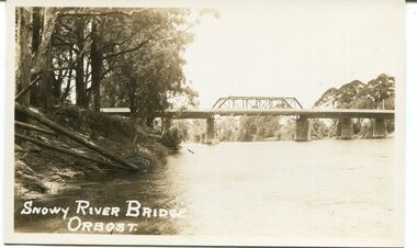
black and white photograph, first half 20th century
This is a photograph of the second Snowy River Bridge at Orbost. The section in the central span could have been built after flood damage. This bridge over the Snowy River was opened on July 4 1922. It was constructed in 1922 alongside the previous suspension bridge. Its building was a combined effort of the Victorian Railways and the Country Roads Board at a cost of 35,000 pounds. It was replaced in 1976 by the present bridge after several major floods.This bridge was replaced in 1976 after several major floods.A black / white photograph / postcard of a bridge over a river. It has what looks like a bo girder in the central section. On the left is the river bank.on front bottom left - "SNOWY RIVER BRIDGE"orbost snowy-river-bridge transport-bridge -
 Orbost & District Historical Society
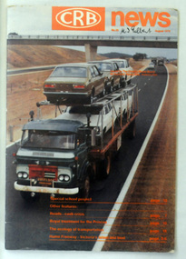
magazine, CRB News, August 1976
... for a central roads authority to take over responsibility from the Board... for a central roads authority to take over responsibility from the Board ...By 1910 it had become apparent that there was a need for a central roads authority to take over responsibility from the Board of Lands and Works for the care and management of the main roads of the state of Victoria. Because there was no consistent and systematic policy for road maintenance Victorian roads were in a deplorable condition. At this time the use of the motor car accentuated the demands for better roads. As a result of these needs the Country Roads Act 1912 was proclaimed in 1913 providing for the establishment of the Country Roads Board as a central road authority with responsibility for those roads within the State considered to be main roads. the C.R.B. was responsible for the construction of roads and bridges including the Snowy River road bridges in Orbost. This was a major project involving not only a new bridge over the Snowy River (including Lochiel Lagoon), but other bridges over Ashby’s Gulch and Watt’s Gulch. These new bridges were opened in November 1976 with the unveiling of a plaque on the eastern end of the $2.4M Snowy River Bridge. (ref. May Leatch) This is a useful reference tool on the history of the construction of the Snowy River road bridges.A journal, titled "CRB News" . On the front cover the title is in orange print with No. 33 August 1976 above a coloured photo of a truck carrying two tiers of new vehicles along a main sealed road. It contains information and photos of the construction of the Snowy River road bridges.on front cover - handwritten in black - "M. I. Gilbert"crb-news country-roads-board snowy-river-road-bridges -
 Flagstaff Hill Maritime Museum and Village
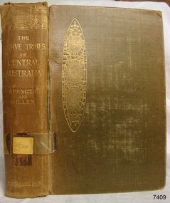
Book, The Native Tribes of Central Australia
This item is from the ‘Pattison Collection’, a collection of books and records that was originally owned by the Warrnambool Mechanics’ Institute, which was founded in Warrnambool in 1853. By 1886 the Warrnambool Mechanics’ Institute (WMI) had grown to have a Library, Museum and Fine Arts Gallery, with a collection of “… choice productions of art, and valuable specimens in almost every branch and many wonderful national curiosities are now to be seen there, including historic relics of the town and district.” It later included a School of Design. Although it was very well patronised, the lack of financial support led the WMI in 1911 to ask the City Council to take it over. In 1935 Ralph Pattison was appointed as City Librarian to establish and organise the Warrnambool Library as it was then called. When the WMI building was pulled down in 1963 a new civic building was erected on the site and the new Warrnambool Library, on behalf of the City Council, took over all the holdings of the WMI. At this time some of the items were separated and identified as the ‘Pattison Collection’, named after Ralph Pattison. Eventually the components of the WMI were distributed from the Warrnambool Library to various places, including the Art Gallery, Historical Society and Flagstaff Hill. Later some were even distributed to other regional branches of Corangamite Regional Library and passed to and fro. It is difficult now to trace just where all of the items have ended up. The books at Flagstaff Hill Maritime Village generally display stamps and markings from Pattison as well as a variety of other institutions including the Mechanics’ Institute itself. RALPH ERIC PATTISON Ralph Eric Pattison was born in Rockhampton, Queensland, in 1891. He married Maude Swan from Warrnambool in 1920 and they set up home in Warrnambool. In 1935 Pattison accepted a position as City Librarian for the Warrnambool City Council. His huge challenge was to make a functional library within two rooms of the Mechanics’ Institute. He tirelessly cleaned, cleared and sorted a disarrayed collection of old books, jars of preserved specimens and other items reserved for exhibition in the city’s museum. He developed and updated the library with a wide variety of books for all tastes, including reference books for students; a difficult task to fulfil during the years following the Depression. He converted all of the lower area of the building into a library, reference room and reading room for members and the public. The books were sorted and stored using a cataloguing and card index system that he had developed himself. He also prepared the upper floor of the building and established the Art Gallery and later the Museum, a place to exhibit the many old relics that had been stored for years for this purpose. One of the treasures he found was a beautiful ancient clock, which he repaired, restored and enjoyed using in his office during the years of his service there. Ralph Pattison was described as “a meticulous gentleman whose punctuality, floorless courtesy and distinctive neat dress were hallmarks of his character, and ‘his’ clock controlled his daily routine, and his opening and closing of the library’s large heavy doors to the minute.” Pattison took leave during 1942 to 1945 to serve in the Royal Australian Navy, Volunteer Reserve as Lieutenant. A few years later he converted one of the Museum’s rooms into a Children’s Library, stocking it with suitable books for the younger generation. This was an instant success. In the 1950’s he had the honour of being appointed to the Victorian Library Board and received more inspiration from the monthly conferences in Melbourne. He was sadly retired in 1959 after over 23 years of service, due to the fact that he had gone over the working age of council officers. However he continued to take a very keen interest in the continual development of the Library until his death in 1969. The Pattison Collection, along with other items at Flagstaff Hill Maritime Village, was originally part of the Warrnambool Mechanics' Institute’s collection. The Warrnambool Mechanics’ Institute Collection is primarily significant in its totality, rather than for the individual objects it contains. Its contents are highly representative of the development of Mechanics' Institute libraries across Australia, particularly Victoria. A diversity of publications and themes has been amassed, and these provide clues to our understanding of the nature of and changes in the reading habits of Victorians from the 1850s to the middle of the 20th century. The collection also highlights the Warrnambool community’s commitment to the Mechanics’ Institute, reading, literacy and learning in the regions, and proves that access to knowledge was not impeded by distance. These items help to provide a more complete picture of our community’s ideals and aspirations. The Warrnambool Mechanics Institute book collection has historical and social significance for its strong association with the Mechanics Institute movement and the important role it played in the intellectual, cultural and social development of people throughout the latter part of the nineteenth century and the early twentieth century. The collection of books is a rare example of an early lending library and its significance is enhanced by the survival of an original collection of many volumes. The Warrnambool Mechanics' Institute’s publication collection is of both local and state significance. The Native Tribes of Central Australia Author: Baldwin Spencer, M.A. & F. J. Gillen Publisher: MacMillan & Co Date: 1899Label on spine with typed text RA 572.994 SPE Pastedown end page has sticker from Warrnambool Mechanics Institute and Free Libraryshipwrecked-coast, flagstaff-hill, warrnambool, flagstaff-hill-maritime-museum, maritime-museum, shipwreck-coast, flagstaff-hill-maritime-village, shipwrecked-artefact, book, warrnambool library, warrnambool mechanics’ institute, warrnambool city librarian, mechanics’ institute library, victorian library board, warrnambool books and records, warrnambool children’s library, great ocean road, the native tribes of central australia, baldwin spencer, f. j. gillen -
Glen Eira Historical Society
Article - Elsternwick Park
This file contains items pertaining to Elsternwick Park: 1/A clipping from the Caulfield/Port Philip Leader (titled ‘Hunter takes reins at Elsternwick’, author unspecified, 17/04/2012), which pertains to Justin Hunter being installed as the captain of the Elsternwick Amateur Football Club. 2/A clipping from the Caulfield/Port Philip Leader (titled ‘Wicks lose a champion’, by Brad Beitzel, undated), which pertains to Graham Holmes of the Elsternwick Amateur Football club dying of cancer. 3/A book titled Bazaar Beginnings: A Century of Sport at Elsternwick Park (author unspecified, undated, 37 pages), which describes the history of Elsternwick Park from 1901 to 2003, with an emphasis on sports.elsternwick park, parks and reserves, sport, sporting clubs, sportsgrounds, australian rules football, elsternwick amateur football club, elsternwick hockey club, sculthorpe a. , elsternwick park committee of management, world war 1939-1945, langford-jones andrew, dunstan mark, todd barry, price , bill, riddell mrs, riddell ken, scott arthur, coombs percy, emburey john, potter jack, holmes graham, blumfield chris, jorgensen james, baxter andrew, taft shura, hunter justin, mahony craig, beddingfield lachie, hodskiss nathan, cesario john, mcdonald jack, rose james, warren phil, gaze andrew, local history, cricket, miller keith r., burgoyne a.d. mr, beadle ken cr., bent thomas, st. kilda cricket club, south st. kilda cricket club, muntz mr, lloyd c.d. cr., fundraising events, ground improvement fund, elsternwick hall, sargood frederick sir, foote ian, hockey, victorian hockey association, elsternwick baptist cricket club, elsternwick methodist cricket club, soccer, brighton soccer club, barr alex, loghran frank, bignell bonb, pettigrew john, morrow bruce, baseball, brighton baseball club, victorian baseball league, victorian baseball association, elsternwick baseball club, brighton football club, williamson col., mcindoe rus, warburton keith, blood michael, sherrin cup, bourke mick, l.a. adamson cup, watt judy, anderson sue, connell brett, lawry bill, stackpole keith, hookes david, hurst alan, graf shaun, madden simon, dipierdimenico robert, parkin david, malthouse mick, cleary phil, madden justin, jordan ray, michael barry, carroll wayne, mildenhall bill, brown joyce, matthews alf, madigan laurie, lane tim, roberts sandy, leonard tony, cover ian, phillips steven, marmalade trevor, fleet greg, whittle slim, marasco con, warne shane, elsternwick, elsternwick hotel, cox charles mr, turner george sir, fairbairn mr, russell-brown j. mr, peacock cr., huntley cr., taylor j.h. mr, elsternwick lacrosse club, elsternwick football club, elsternwick district football club, elsternwick junior football club, victorian amateur football association, elwood central school, elsternwick primary school, australian broadcasting commission, mcdonald a.j. mr, mccutcheon r.g. mr, melbourne cricket club, victorian cricket league, wardill b. mr, melbourne & metropolitan board of works, elsternwick golf club, clubs and associations, balme kate, stevens phil, new tommy, pratt bob, elsternwick cricket club, searle barney, blundell norm, power john, gartrell rob, victorian junior cricket association, victorian turf cricket association, australian cricket board, victorian cricket association, russell simon cr. , white cameron, abbey alan, blizzard aiden, bull adam, murphy liam, scorgie stuart, tenace kane, victorian women’s cricket association, hunt reg, hatch ron, community groups, elliot matthew, fraser colin, pike arthur, young darryl, mills alf, werf pat van der, leather tom, gregory ross, fullerton norma, sharkie keith, johnson alex, dixon brian, trezise neil, rundle noel, corner donald dr., loysh len cr., french peter, francis chris, johnson cameron, miles john, de la salle old collegians club, old xavierans club, victorian amateur football association umpires’ association, hinton wayne, cultural events and activities -
 Federation University Historical Collection
Furniture - Honour Board, Herbert Henry Smith, Ballarat Junior Technical School World War I Honor Board, c1921
The Ballarat Junior Technical School (BJTS) was the junior division of the Ballarat School of Mines.The honor board was unveiled on 17 June 1922 by Sir Alexander Peacock, the Minister for Public Instruction. it was witnessed by a large gathering of parents, friends, students, past student, Albert Steane (Headmaster) and the president, Council and Staff of the Ballarat School of Mines. At the conclusion of the ceremony the junior Technical School was opened for public inspection and afternoon tea was provided by a ladies committee. The Honour Board contains 28 names and of these only one lost his life on active service. this was Francis G. Davis. After the unveiling his father, A. Davis, planted a tree in the grounds of the Junior Technical School in memory of his deceased son. The following names are on the Honour Board Adair, S.H. Allen, W.I Bennett, H.G Bernaldo, Allan Borradale, Robert Brittain, C.C.. Burge, A.A. Burrow, B.C. Carmichael, N.C. Carnegie, G Collins, H.A. Crick, R.J Cunningham, C Davis, Francis G (killed) Edwards, S.F. Frank, P.C. Gilbert, J.H. James, J.F. Leech, G.J. McGrath, D.G. McNab, J.C. Parkin, R. Paterson, W.J Ronaldson, L.A. Shannon, G.O. Steele, S.L. Terry, W.R. Townsend, S.H. A timber honour board with names written in gold. The board was designed by H.H. Smith, Principal of the Ballarat Technical Art School. A central case holds a copy of the Victorian Education Department War Service Book.world war one, ww1, ballarat school of mines, ballarat junior technical school, alexander peacock, world war 1, world war i, honour roll, hh herbert, francis davis, frank davis, s.h. adair, w.i. allen, h.g. bennett, allan bernaldo, robert borradale, c.c. brittain, a.a. burge, b.c. burrow, n.c. carmichael, g. carnegie, h.a. collins, r.j. crick, c. cunningham, s.f. edwards, p.c. frank, j.h. gilbert, j.f. james, g.j. leech, d.g. mcgrath, j.c. mcnab, r. parkin, w.j. paterson, l.a. ronaldson, g.o. shannon, s.l. steele, w.r. terry, s.h. townsend -
 Flagstaff Hill Maritime Museum and Village
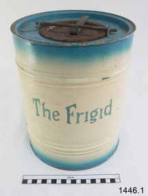
Freezer, circa 1930's
This ice cream freezer, manufactured in South Australia in the 1930's, was advertised to "keep the contents of the cream compartment frozen for many hours". It was promoted for use at picnics to keep salads cool. Its design is very similar to other freezers of The Frigid name which were made in 1939; those freezers were all one colour whereas this one is blue around the top and bottom of the barrel and cream in the centre with blue/green lettering. The process of making ice cream was to pack the outer chamber full with a combination of 3 parts ice cubes of about 1 inch (2.cm) to one part coarse salt, then pour into the chamber about 1 cup of cold water. After this, the ingredients for ice cream or sorbet were poured into the inner chamber, then attach the lid and turn The Frigid freezer upside down for about 40 minutes or until the right consistency is reached. Advice as given to open the freezer every 20 minutes and stir around the contents that were frozen against the sides of the inner chamber. The ingredients for the ice cream could include cream, sugar, vanilla and eggs. The label on the box of The Frigid shows the address of A Simpson and Son to be at Pirie Street, Adelaide. This address was used as early as 1876 and later catalogues, 1931 - 1960 still show this address. Alfred Simpson and his family emigrated from England, arriving in South Australia in 1849. He had already completed his apprenticeship as a tinplate worker but he tried various other occupations, including trying out the gold mines in Victoria, before he established himself as a tinsmith in 1853. His products included many agricultural items. His son, Alfred Muller Simpson, joined the business when he turned 21. In the 1860 Simpson's products included 'explosion proof' safes. In the late 1880's A Simpson and Son manufactured munitions and mines for the war. At the time of Alfred's death in 1891, A Simpson and Son had the largest metal manufacturing plant in Australia. From 1898 the company's reputation grew from the process of enamel plating with porcelain. During the First World War, Simpsons returned to the manufacture of munitions. Alfred M. Simpson's sons (Alfred Allen, known as Allen, and Fredrick Neighbour) joined the company when they finished their schooling. Allen was also associated with the Royal Geological Society over many years and when the CT Madigan surveyed Central Australia in 1929, the Simpson Desert was named in his honour. Cape Simpson in Antarctica is also named after him due to his assistance to Douglas Mawson. A new factory was opened at Dudley Park in the 1940s and the company began the manufacture of whitegoods. In 1963 A. Simpson and Son merged with Pope Industries to form Simpson Pope Holdings. Alfred Simpson became chairman of the board of Simpson Pope Holdings. The Simpson brand, now owned by Electrolux, continues to produce a variety of household appliances. (Reference: State Library of South Australia) A Simpson and Son was an early colonial business that has lasted well into the 20th century and the name Simpson is still associated with whitegoods. Freezer, 2 quart (1.8 litre) capacity, made by A Simpson and Son Ltd, marked "The Frigid". Cylinder shaped, constructed from enamelled sheet metal, has two catches one on the base and one on top. Inner cylinder for holding contents for freezing. Slightly rusted. Freezer is inside original cardboard box with yellow label showing manufacturer details. Circa 1930'sOutside of freezer is printed in blue"The Frigid". Box includes "THE "FRIGID" FREEZER" and branded "S & S" inside a circle.flagstaff hill, warrnambool, shipwrecked-coast, flagstaff-hill, flagstaff-hill-maritime-museum, maritime-museum, shipwreck-coast, flagstaff-hill-maritime-village, a. simpson & son limited, manufacturer, foundry, freezer, 2 quart freezer, portable freezer, kitchen appliance, the frigid, ice cream freezer, ice cream maker 1930's -
Federation University Historical Collection
Booklet, Central Highlands/Wimmera Regional TAFE Board Annual Report, 1986-87, 1987
Brown soft covered booklet of 16 pages. tafe, central highlands/wimmera regional tafe board, annual report, glen ludbrook -
 Federation University Historical Collection
Letter, Ballarat School of Mines, 1908, 1908
October inwards correspondence for the Ballarat School of Mines. * School of Mines and Industries, Bendigo (certification of Mine Managers) * Telegram - examination papers * Commonwealth telegram - Ballarat School of Mines battery availability for crushing ten tons. * Letterhead from the Roneo Co., Melbourne * J. Donald of Wallace St, Toorak * Letterhead from York Chambers, 49 Queen Street, Melbourne - signed J. Kaufmann * Letterhead from Cochran & Co - re Cocnran boilers * Letterhead of Thames School of Mines, New Zealand * Letter re James Chambers missing school from his father James Chambers Snr of Talbot * Education Department Circular * letter signed by F.W. Calaby * F.W. Silberberg & Co re crucibles * Letterhead of New Black Horse Mining Company - signed E. Howell * Australasian Institute of Mining Engineers, 57-59 Swanston Street, Melbourne - signed D.L. Stirling * Letterhead of John F. Paterson * Letterhead of the Welcome Stranger Dredging Company, Dunolly - W.J. Parker manager * Letterhead of Nevett and Nevett Barristers and Solicitors, Lydiard Street, Ballaarat * John Barker, H. Barbour * Telegram re Brearley Lyndhurst * Letterhead of the Commonwealth Minerals Co - John F. Paterson, Legal Manager * Query re courses at the Ballarat School of Mines - A. O'Mara * Stone to be crushed, Egerton from J.H. Davidson * Letterhead from 'Terascoa' Port Kembla signed by W.S. Macartney * Letter from Thomas Williams * Letterhead from Australian Institute of Mining Engineers regarding excursion to Toongabbie and Walhalla - Signed D.L. Stirling * Assay from George Brearley of Lyndhurst via Scottsdale * Letterhead of Berry United Deep Leads Limited, Ulina * Embossed leather classes for coachwork from S. Mee of Clunes * The Lord Nelson North Gold Mning Company No Liability signed by Edward H. Shackell * Correspondence from May Consolidated Gold Mining Company, Transvaal signed by Jason Hawthorne * Letterhead of the Northern Assurance Company, 448 Collins St, Melbourne * Letter fom James Lidgett of "Braelands" Myrniong * Gordon sides asking for a reference * Letterhead of Fraser & Chalmers Ltd, Manufacturersw of mining machinery, steam engines, boilers and machinery for systematic milling, smelting and concentration of ores, signed by W.R. Caithness * Letterhead of the Board of Examiners for Engine-Drivers, signed by R. Birrell * Letter concerning outstanding amount due to theBallarat East School of Design, signed by Edward Reid, Manager * Letterhead of the Ballarat Public Library concerning an outstanding amount in the School of Design Account. * Letterhead of the A. Gallenkamp and Co. regarding their new catalogue * Letterhead from the Creswick Advertiser, Albert Street, Creswick * Handwritten letter from John Brittain inviting Ballarat School of Mines students to join him at the telescope weather permitting * Letterhead of Victorian Railways, signed by E.B. Jones * Letterhead of the Ballarat East Town Clerk's Office * Letterhead of Elliott, Maclean and Co. Handwritten letter re Dressmaking from J.H. Wrightrand, south africa, kalgoorlie, school of mines and industries, bendigo, certification of mine managers, bendigo school of mines, telegram, ballarat school of mines battery, roneo co., melbourne, j. donald, york chambers, cochran & co, thames school of mines, new zealand, james chamberseducation department circular, f.w. calaby, * f.w. silberberg & co, crucibles, new black horse mining company, e. howell, * australasian institute of mining engineers, john f. paterson, welcome stranger dredging company, dunolly, w.j. parker, nevett and nevett, john barker, h. barbour, brearley lyndhurst, commonwealth minerals co, a. o'mara, j.h. davidson, 'terascoa' port kembla, w.s. macartney, thomas williams, australasian institute of mining engineers, excursion, toongabbie, walhalla, d.l. stirling, george brearley, lyndhurst via scottsdale, berry united deep leads limited, ulina, embossed leather classes for coachwork, s. mee, clunes, the lord nelson north gold mning company no liability, edward h. shackell, may consolidated gold mining company, transvaal, jason hawthorne, northern assurance company, james lidgett, "braelands" myrniong, gordon sides, fraser & chalmers ltd, mining machinery, w.r. caithness, examiners, ballarat east school of design, edward reid, ballarat public library, school of design, a. gallenkamp and co., creswick advertiser, john brittain, telescope, victorian railways, e.b. jones, ballarat east town clerk's office, elliott, maclean and co., dressmaking, j.h. wright, ausimm, berry united, school of mines and industries bendigo, lyndhurst tasmania, may consolidated gold co germiston transvaal, transvaal, germiston, roneo, thames school of mines, schools of mines, welcome stranger dredging co, cowley copper development syndicate ltd, department of mines, maryborough school, pharmacy board of victoria, tongalla survey camp, ballarat fine art gallery association, central microscopical -
 Federation University Historical Collection
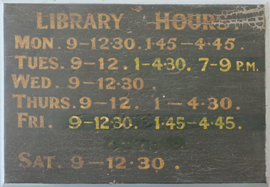
Plant specimen - Noticeboard, Ballarat School of Mines Library Hours Sign
The board was probably from the School of Mines Library, located on the 1st floor of the Administration Building in Lydiard Street. Changes have been made to some times for Tuesday and Friday. The E J Tippett Library was opened in 1978 at the SMB Campus.Wooden board with bevelled and painted edge in blue-grey. Front surface painted black with gold coloured letters and numbers. Two bolts, washers and nuts for fixing, held in position by central wooden strip pinned on back by four screws.ballarat school of mines and industries, library, e. j. t. tippett -
 Federation University Historical Collection
Photograph - Photograph - Black and White, Silver Birch in the Ballarat School of Mines Gardens
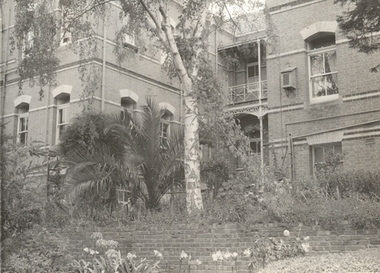
The Ballarat School of Mines Botanical Gardens were established in 1879, and are situated at the rear of the current administration building. The gardens enabled the students to sit for examinations for registration by the Pharmacy Board of Victoria. An important aspect of this course was the study of Materia Medica, or botanical materials used for medicinal purposes.Black and white photograph of the garden at the back of the Ballarat School of Mines Administration Building. In central position is a Silver Birch.smb botanical gardens, botanical gardens, smb, ballarat school of mines, school of mines ballarat, ballarat, photograph -
 City of Moorabbin Historical Society (Operating the Box Cottage Museum)
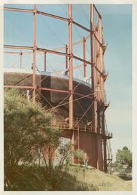
Photographs, x3 Colour,, Highett Gasworks c1974, 1974
3 of 5 photographs of the Highett Gasworks c 1974 The Brighton Gas Company was established 1877 by local residents including Thomas Bent. Initially all went well for residents as gas light replaced kerosene lamps and street lights were installed. However disruption to supply, poor quality and failure to reach all house lead to dissatisfaction. Thomas Bent therefore began the Central Brighton and Moorabbin Gas Company 1885 and a price war ensued. This was unsustainable and the two companies amalgamated in 1877 supplying gas from the New Street Works site. 1930 this Company expanded to Highett where it had purchased 45 acres adjacent to the train line. 1927 a gas holder was built connected to the Brighton works 1936 construction began on a complete gas-making unit and the Highett Gasworks, Nepean Highway, began supply 1939. 1950 an extension program was completed. However by 1965 , with the discovery of Natural Gas offshore in Bass Strait, changes to Gas distribution were apparent. At first some of the facilities at Highett were used to distribute the gas piped from Sale, Gippsland. However after conversion of 450,000 homes to Natural Gas the Highett site was redundant. The gasometers were removed 1978. Moorabbin Council obtained part of the land for public recreation purposes. ( Dr. G Whitehead KCC Historian ) c2012 the Moorabbin Justice Centre / Magistrates Court of Victoria was built and further development of the area for apartments proceeds. The establishment of the Brighton Gas Company 1877 and the Highett Gasworks 1885 brought bright lighting to houses, businesses and streets in Moorabbin Shire and cooking ovens and heating improved the living conditions of residents. 3 x Colour photographs of the Highett Gasworks c1970bass strait gas, highett gasworks, brighton gasworks 1877, central brighton and moorabbin gas company 1885, whitehead dr. graham, magistrates court of victoria, horse drawn carts, toll gates brighton, motor cars 1900, steam engines, early settlers, bentleigh, parish of moorabbin, city of moorabbin, county of bourke, moorabbin roads board, shire of moorabbin, henry dendy's special survey 1841, were j.b.; bent thomas, o'shannassy john, king richard, charman stephen, highett william, ormond francis, maynard dennis, market gardeners, vineyards, orchards -
 City of Moorabbin Historical Society (Operating the Box Cottage Museum)
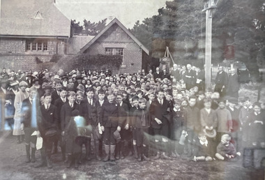
Photograph - B/W Bentleigh SS No.2083, 1920
The Common School No. 213 East Brighton 1864 - 1878 replaced the original St Stephen's Church of England School in Tucker Road. 1878-1908 the School was known as Education Department State School No. 2083 Brighton East. 1908 - 1936 the School changed it's name to Bentleigh and then from 1936 - 1993 was known as East Bentleigh. 1993 the school was closed due to low enrollments and the building was demolished and land sold. Eric Hutchinson, the uncle of Les Hutchinson, attended this school. Eric is second row far left ' behind the boy with the white handkerchief '. The 1920 gathering may be for the unveiling of a World War 1 Honour Roll - for past students killed or injured - as can be seen at the back of the group A flag pole may be the central wood post as all the boys and men have removed their hats and caps. A school photograph of one of the original schools in the Bentleigh area showing a gathering of adults and children who had connection with this school either as teachers, pupils, parents or neighbours in 1920.A black & White photograph showing a group of adults and children in front of Education Department State School Bentleigh no. 2083 in 1920 (Reprint)education, st stephens anglican school east brighton, education department state schools, state school number 2083, coates charles j, hutchinson eric, hutchinson les, tucker road bentleigh, henry dendy special survey brighton 1841, market gardeners, dairy farmers, poultry farmers, early settlers, pioneers, tuck family bentleigh, moorabbin shire, moorabbin roads board, city of moorabbin, bent thomas -
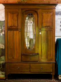 City of Moorabbin Historical Society (Operating the Box Cottage Museum)
Furniture, Wardrobe 3 piece 3 drawers c1900, c1900
The sections of this wardrobe can be lifted apart so that it can be transported easily and when assembled provides suitable hanging and storage space for the clothes and bed covers of an early settler family This wardrobe is of a type commonly used by early settler families in Moorabbin Shire c1900Wooden Wardrobe with 3 sections- top, hanging space with a central oval glass window, a shallow central drawer and 2 doors with key locks, and drawer section with 2 deep drawers early settlers, market gardeners, poultry farmers, mechanics institutes, furniture, kitchen equipment, clothing, drapery, haberdashery, green pederson carol, city of moorabbin, county of bourke, moorabbin roads board, parish of moorabbin, shire of moorabbin, henry dendy's special survey 1841, were j.b.; bent thomas, highett william, ormond francis, maynard dennis, -
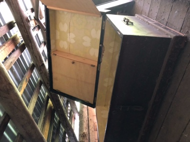 City of Moorabbin Historical Society (Operating the Box Cottage Museum)
Functional object - Travel Trunk ,wood, brass handles, hinges and lock c1860
A handmade wood travel trunk, with internal cupboard fastened by wing clips, side brass handles, brass hinges and a central brass lock with latch for padlock Early settlers used these handmade trunks to bring their worldly goods to the new Settlements in Australia c1850A typical travel trunk used by pioneer settlers as they traveled on sailing ships from Europe to Australia c 1852A Handmade wood Travel Trunk , with internal cupboard, brass handles, lock and hinges c 1860NILpioneers, moorabbin shire, dendy's special survey 1842 brighto, dendy henry, were j.b., moorabbin roads board, market gardeners, early settlers, bent thomas, sailing ships, emigration to melbourne 1850, methodist church, henry box, holloway josiah, box willian, poultry farmers, flower farms, orchards -
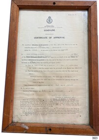 Flagstaff Hill Maritime Museum and Village
Document - Certificate of Approval, Load Line, 25-02-1970
This Certificate, Load-Line, gave approval for the vessel Reginald M to load cargo up to a certain line, marked by a disc attached to the ship and inspected by the South Australian Harbors Board. The vessel had a long and varied life of service. This Certificate relates to early 1970, before the ship was sold to the Lyall Mining and Rail Company. The Load Line on the Reginald M was carved on the ship, inside the hull and not removeable. The REGINALD M - The vessel “Reginald M” was a two-masted coastal ketch, owned and built by Mr. Jack (John) Murch of Birkenhead, Port of Adelaide, South Australia. Its construction took approximately 6 months and it was launched at Largs Bay in 1922. The Reginald M’s purpose was to serve the coastal trade of South Australia, to carry cargo cheaply and efficiently. It is believed that the keel was in fact hewn from two telegraph poles! Its builder frequented all the salvage yards for materials and fittings. Reginald M had a very shallow draft and a flat bottom that enabled it to come close to shore and to sit high and dry at low tide or to be beached on sand. The flat bottom was also to make the ship able to skim over reefs. Wagons could load and unload direct from her side. Her cargo included Guano, Barley, Wool, Horses, Cattle, Timber, Explosives, Potatoes, Shell Grit and Gypsum. After a variety of services, in late 1970 Reginald M was sold to the Mt. Lyell Mining and Railway Company and was used by them as a barge to carry explosives. In 1972 the Navy League of Strahan, Tasmania, purchased her for use by the Strahan Sea Cadet Unit to use at Macquarie Harbour and renamed her T.S. Macquarie. However this plan for use of Reginald M did not come to pass. In 1974 Mr. Andrew Rennie, of East Brighton, Melbourne, bought her for a similar purpose. , paying $5,000 and donating a ‘Cadet of the Year” trophy to the Sea Cadets. He sailed her from Strahan to Melbourne, planning to use her for pleasure sailing. Also in 1975 Reginald M was sold to Melbourne Ferry Company at auction. Later in 1975 the Reginald M was bought by Flagstaff Maritime Museum for $20,000 . She has been restored and is now one of the exhibits in the Village lagoon or lake. It was restored in 2006 using funds from a $4,000 government grant.This Certificate is significant because of its association with the last working days of REGINALD M. REGNIALD M was a coastal trading ketch from South Australia built in 1922. It was one of very few sailing coastal trading vessels still existing until 2016, and its flat bottom, single chine shape illustrated a very simple but robust method of construction, compared to other round bilged examples of trading vessels. The vessel is listed on the Australian Register of Historic Vessels (ARHV Number: HV000562.)Certificate, rectangular, behind glass in wooden frame. Certificate is an official printed form, some information is over-typed, other information is hand written and signed. Frame has a central hole in top and bottom. The Certificate relates to Load Level of the vessel Reginald M and refers to the exact placement of a disc within the vessel that indicates the maximum load in fresh water. . Issued to the vessel 'Reginald M', Official Number 137228. . Issued by the Sough Australian Harbors Board . Valid from 25-02-1970 to 31-01-1974. . Signed by Neil Cormack, 25th February 1970Certificate of Approval - Load Line for sailing vessel Reginald M, Official Number 137228. Logo of the South Australian Harbors Board. Issued by Department of Marine & Harbors, Port Adelaide, 25th February 1970. In force until 31st January 1974. Signed by Neil William Cormack, authorised officer for Department of Marine & Harbors. Typed onto form: "AUX [SAILING SIP]" "REGINALD M" "137228" "1968" " Neil William Cormack" "Department of Marine & Harbors" "1 [foot] 3 [inches below the] main [deck]" "31st JANUARY 74" "25th FEBRUARY 70" Signature: "Neil W Cormack"flagstaff hill, warrnambool, maritime village, maritime museum, flagstaff hill maritime museum & village, shipwreck coast, great ocean road, coastal trader, reginald m, ketch, john murch, ch murch, reg webb, carribie station, mt lyell copper company, melbourne ferry company, certificate of approval, load line, 137228, load line disc, 25-02-1970, neil w cormack, neil william cormack, south australian harbors board, department of marine and harbors, harbours -
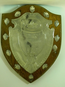 Cobden & District Historical Society
shield, The London Australian Dairy Produce Importers' Association Export Butter Championship Challenge Shield
... A wooden shield shaped board incorporating one large... shield shaped board incorporating one large central aluminium ...A wooden shield shaped board incorporating one large central aluminium shield naming the contest, with an Australian crest at the top and including a pictures of a cow at the bottom. Surrounmding the large shield are 12 small aluminium plaques.THE LONDON AUSTRALAIAN DAIRY PRODUCE IMPORTERS' ASSOCIATION EXPORT BUTTER CHAMPIONSHIP CHALLENGE SHIELD WON BY COBDEN DISTRICT CO-OPERATIVE PIONEER CHEESE & BUTTER FACTY. CO. LTD. VICTORIA. SEASON 1930-31 AVERAGE GRADE 94 - 11 POINTS -
 Bendigo Historical Society Inc.
Document - NORMAN OLIVER COLLECTION: MELBOURNE HERALD, 25 MAY 1952
... Norman Oliver. Library Board. Wellington (NZ). Wellington... COTTAGE Miners Norman Joseph OLIVER Norman Oliver. Library Board ...The Norman Oliver collection. Norman Oliver was three times Mayor of Bendigo - 1950-51, 1964-65, 1970-71. Two typed pages titled : Article 11. On New Zeeland for Melbourne Herald. By Emerald A. Goetzee. Dated : Wellington. May 25th 1952. The article includes a detailed description of the building and operations of the Wellington Central Library and mentions the other two Wellington libraries and other important buildings. Signed (typed) at the bottom of pl 2 Emerald. A. Goetzee. c/- A.N.Z. Bank, Box 31. P.O. Auckland, N.Z. In pencil on the back of p. 2 is written, ANZ Bank, Box 31 Auckland. Norman Oliver was a member of the Library Board of Victoria at one stage.cottage, miners, norman joseph oliver , norman oliver. library board. wellington (nz). wellington central library. -
 Bendigo Historical Society Inc.
Document - LONG GULLY HISTORY GROUP COLLECTION: TRAMS INFORMATION
Information on O Class Trams, First introduced, Last Withdrawn, Electrics, Size and Seating, W2 with a small photo, where they can be found, some went to the USA, W5 with a small photo, W6 and the Bendigo Toastrack Tram with Nos, Introduced, Withdrawn, Electrics, Size and Seating/Crush Load. Also listed is where other trams can be seen. Also mentioned some early history of Bendigo, The Heritage Walk, The Central Deborah, Sandhurst Town, the early route from Melbourne to Bendigo, Creswick, Castlemaine and the Old Market. (7 pages).bendigo, history, long gully history group, the long gully history group - trams information, prahan and malvern tramway trust, hawthorn tramway trust, melbourne and metropolitan tramways board, australian electric transport museum, david hoadley, tramway musuem of victoria, hawthorn tram depot, david bromage, sydney tramway museum, bendigo tramways, museum of transport and technology nz, whiteman park tramway museum, haddon tramway museum, the old canberra tram company, ballarat vintage tramway, bendigo toastrack tram, kilmore cable tramway, railway museum, scienceworks, tasmanian transport museum, launceston tramway museum society, ballarat vintage tramway, central deborah gold mine, chinese joss house, castleton, sandhurst, shamrock hotels, dai gum san wax museum, post office, law courts, alexandra fountain, beehive store, fortuna villa, sandhurst town -
 Bendigo Historical Society Inc.
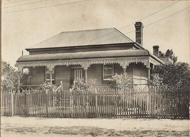
Photograph - T C WATTS & SON COLLECTION: HARNEY STREET, BENDIGO, 1930
Thomas Crouch Watts was born on March 7th. 1865, to Joseph and Susan Watts. Before the real estate business commenced, Thomas and his brother were in partnership as booksellers and stationers in a shop at View Point. Thomas lived in a fine house in Rowan Street, which was called 'Ottawa' Thomas started his real estate business in the early 1900s in a shop in View Street. His daughter Edna was the book keeper and typist, Stewart Watson was the salesman and Stanley Phipps (Edith Lunn's father) was the property manager and valuer. When Thomas Watts died in 1914, his daughter took over the running of the business. She married Stewart Watson in 1918. Eventually the name of the business was changed to Bishop and Earl. From a letter from Edith Lunn re T.C. Watts & Son. 'The firm of T.C. Watts & Son later became Bishop and Earl. When the firm of Bishop and Earl ceased to operate after the death of Edith Lunn's father, S.P. Bishop, Miss. June Parry, Secretary of the BHS was a member of staff. June rescued all the photos of properties listed for sale from the office and placed them into the custody of the BHS.' Black and white photograph mounted on rectangular brown board. House, weatherboard corrugated iron roof, bull nose verandah, picket fence, cast iron lace on verandah, 2 chimneys, central door, 1 window each side of door, wooden steps up to return verandah, Written on back of image 'Hunt, Harney Street, £575 Sewered' Faint stamp on back with date 11 April 1939. £250 deposit. Low interest to be arranged'Frank A. Jeffree, Bendigoplace, building, residential, previous register no. ''mp 10'' part of a collection of photographs used by estate agent t.c. watts and son -
 Bendigo Historical Society Inc.
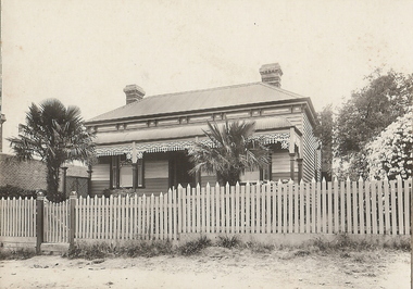
Photograph - T C WATTS & SON COLLECTION: 320 BARNARD STREET, BENDIGO, 1927
Thomas Crouch Watts was born on March 7th. 1865, to Joseph and Susan Watts. Before the real estate business commenced, Thomas and his brother were in partnership as booksellers and stationers in a shop at View Point. Thomas lived in a fine house in Rowan Street, which was called 'Ottawa' Thomas started his real estate business in the early 1900s in a shop in View Street. His daughter Edna was the book keeper and typist, Stewart Watson was the salesman and Stanley Phipps (Edith Lunn's father) was the property manager and valuer. When Thomas Watts died in 1914, his daughter took over the running of the business. She married Stewart Watson in 1918. Eventually the name of the business was changed to Bishop and Earl. From a letter from Edith Lunn re T.C. Watts & Son. 'The firm of T.C. Watts & Son later became Bishop and Earl. When the firm of Bishop and Earl ceased to operate after the death of Edith Lunn's father, S.P. Bishop, Miss. June Parry, Secretary of the BHS was a member of staff. June rescued all the photos of properties listed for sale from the office and placed them into the custody of the BHS.' Black and white original photographs (2) mounted on grey board house, weatherboard, bull nose veranda, picket fence, cast iron lace on verandah, three chimneys, central door, one window each side of door. Front of house, top section, painted white. Written on back of photo board (a) ' Mr. B. Murdoch, 320 Barnard Street Bendigo, £900 sewered' On back of (b) L. Simmonds, 239 Barnard St. £620' ( Address does not match with photo (a)) Date stamp 9 Dec 1927' 2012 photo of house attached to record. Faint printing in white in lower right corner ''Frank A. Jeffree Photo Bendigo'' Handprinted top R ''MP8''place, building, residential -
 Bendigo Historical Society Inc.
Photograph - T C WATTS & SON COLLECTION: PLUMRIDGE STREET, WHITE HILLS, Approx. 1900-35
Thomas Crouch Watts was born on March 7th. 1865, to Joseph and Susan Watts. Before the real estate business commenced, Thomas and his brother were in partnership as booksellers and stationers in a shop at View Point. Thomas lived in a fine house in Rowan Street, which was called 'Ottawa' Thomas started his real estate business in the early 1900s in a shop in View Street. His daughter Edna was the book keeper and typist, Stewart Watson was the salesman and Stanley Phipps (Edith Lunn's father) was the property manager and valuer. When Thomas Watts died in 1914, his daughter took over the running of the business. She married Stewart Watson in 1918. Eventually the name of the business was changed to Bishop and Earl. From a letter from Edith Lunn re T.C. Watts & Son. 'The firm of T.C. Watts & Son later became Bishop and Earl. When the firm of Bishop and Earl ceased to operate after the death of Edith Lunn's father, S.P. Bishop, Miss. June Parry, Secretary of the BHS was a member of staff. June rescued all the photos of properties listed for sale from the office and placed them into the custody of the BHS.' Black and white photograph mounted on rectangular grey board. House, weatherboard, corrugated iron roof. Bull nose veranda painted with stripes, picket fence, two wrought iron gates, one chimney, central door, one window each side of door. Three boards painted white, half way up front wall. Pergola on RH side of house. Tank stand LH side middle distance, name of house to left of door. 'Phillips, Plumridge Street, White Hills' written on back of photo board. 2012 photo of house attached to record.Frank A. Jeffree, Bendigoplace, building, residential -
 Bendigo Historical Society Inc.
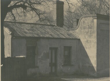
Photograph - COTTAGE, 1930 ?
black and white photograph: cottage, galvanised iron roof, stone construction. Central door, sash windows, 2 chimneys. Right of photo word ' Boar' Picture taken late Autumn. Handwritten in ink ' City Hotel, Barnard St., Cnr. Mercy Street ' Written in pencil ' this is the Mercy Street entrance, demolished in the 1950's'. Occupiers ' Mrs. W. Moore, board and residence later - Mrs Burns confectionary, shop about 1914. Later - Nielson Family 1920's - 1930's to ? ( Will Nielson was night worker at Cohn's Brewery )buildings, residential, cottage -
 Bendigo Historical Society Inc.
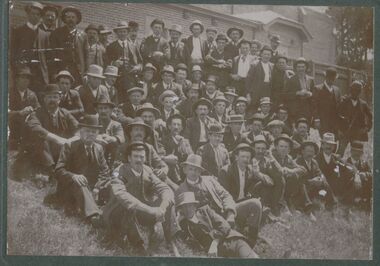
Photograph - CENTRAL RED WHITE AND BLUE MINE
sepia photograph on green board : group of men at the Central Red, White and Blue Mine. Men are dressed in suits, waistcoats, hatsMine Manager George Kingsley, back row 3rd from right. ( James Lerk 20.10.2000 ) On back of photo Mng 29. Photo taken outside Violet Street, State School.A. Schilling ( Photographer )person, group, central red, white and blue mine -
 Bendigo Historical Society Inc.
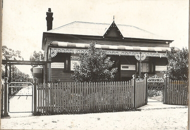
Photograph - VICTORIAN HOUSE: BRICK
Sepia photograph mounted on cream board. Brick house with cream brick quoins at corners and windows. Central door, 1 window on each side. Corrugated iron roof, verandah with iron lace, 2 chimneys, cast iron fence with decorative wooden posts and brick base. Corrugated iron in bottom half of gate, tree at left. Woman standing on verandah. Woman wearing floor length dark dress and hat. On back rubber stamp, oval shaped, 'Clark Bros, photographers, 25 Thomas St., Windsor.Clark Bros. Windsor.buildings, residential, victorian -
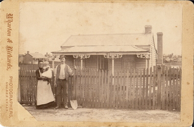 Bendigo Historical Society Inc.
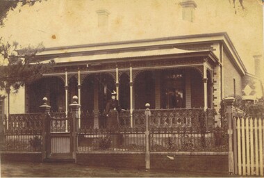
Photograph - MINER'S COTTAGE AND FAMILY, approx. 1890's
sepia photograph, cream board. Worker's cottage, picket fence, 2 chimneys, man with shovel. Woman holding child dressed in white pinafore. Verandah with unusual fretwork. Wooden decoration at posts. 2 windows, one each side of central door. 2 brick chimneys. Cottage in LH background. On back in writing 'Mr and Mrs Wearne' in grey lead pencil.Wharton and Rickards, Photographers, Golden Gullybuildings, residential, miner's cottage