Showing 107 items
matching colonial land
-
 Bendigo Historical Society Inc.
Document - EXTRACT FROM UNKNOWN SOURCE: CHARLES SHERRETT, MOUNT ALEXANDER
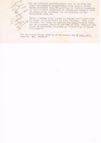
Extract from unknown source re Charles Sherrett, Mount Alexander. This typewritten two paragraphs related to a letter from Captain Lonsdale to the Colonial Secretary (1840) re depasturing of stock on Crown Land at Port Phillip, licences and the mention of Charles Sherrett ''travelling to Mount Alexander'' as place of residence. In a handwritten (crossed out??) note to the side of this typewritten extract is the following: ''Letter of the Town Clerk Bgo 1929 re correct date to celebrate centenary''.document, memo, report, captain lonsdale. licences. charles sherrett.. -
 Bendigo Historical Society Inc.
Book - 1954 VICTORIA ANNO TERTIO ELIZABETHÆ SECUNDÆ REGINÆ NO. 5842, 17/8/56
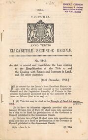
A small book owned by Accountant & Auditor Harold Curnow detailing the "Simplification of Title to and the Dealing with Estates and Interests in land for for other purposes", it also has the date 17/8/56 written in pencil on the top left corner. The first page is written as following. "17/8/56 Harold Curnow Accountant & Auditor Colonial Mutual Building View Point, Bendigo 1954 VICTORIA ANNO TERTIO ELIZABETHÆ SECUNDÆ REGINÆ No. 5842. An Act to amend and colidate the law relating to the Simplification of the title to and the Dealing with Estates and interests in Land and for other purposes. [14th December, 1954.] Be it enacted by the Queen's most Execellent Majesty by and with the advice and consent of the Legislative Council and the Legislative Assembly of Victoria in this present Parliament assembled and by the authority of the same as follows (that is to say) 1. (1) this Act may be cited as the Transfer of Land Act 1954. (Short title commencement and division) (2) (a) Save as otherwise ecpressly provided this act (except Division two of Part II.) shall come into operation on a day to be fixed by proclamation of the Governor in Council published in the Goverment Gazette. (b) Division two of Part II. shall come into operation on such later day as is fixed by proclamation of the Governor in Council published in the Goverment Gazette 6325/55 -Price 3s. 9d. (3) This"victoria -
 Bendigo Historical Society Inc.
Book - CITY OF BENDIGO HISTORICAL WALK BOOK, 2001
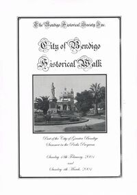
Photocopy mock up of original booklet of The Bendigo Historical Society Inc. 'City of Bendigo Historical Walk' containing photographs of historic buildings to be seen on the walk. Front cover Queen Victorian Gardens, Town hall, Mechanics Institute/School Of Mines and Industry, H. M. Prison Bendigo, Camp Hill Police Barracks, Sandhurst Corporate High School, Central State School No. 1976, The Cascades, District Lands Office (Dudley House), Masonic Temple and Hall, Sandhurst Volunteer Rifle Brigade Orderly Room, Bank of Victoria, Henry Jackson's Store View Point,Alexandra Fountain, Beehive Store/Mining Exchange, Colonial Bank. Hustlers Royal Reserve NO. 2/R.S.L. Memorial Hall, Post Office 3rd 4th and final, Bendigo Law Courts, Shamrock Hotel 2nd and another view. Important Bendigo Dates; 1851, April gold discovered at Golden Square by Margaret Kennedy,1851 Approx. 200,000Troy oz. of gold found in Bendigo, 1852 475,857 Troy oz. Gold for the year, 1853 November 31st Bendigo Hospital admits first patient,1853 December 9th Bendigo Advertiser first issue printed, 1854 First Land Sales and streets are surveyed and named for the first time, 1854 Census of Bendigo showed 15,480 residents plus 4,000 Chinese, 1855 Sandhurst Municipal District formed, 1861 Sandhurst Proclaimed a Town. 1862 Railway to Melbourne opened, 1867 Visit by His Royal Highness the Duke of Edinburgh, 1871 July 21st Sandhurst proclaimed a City, 1881 Population of Sandhurst 14,577 residents, 1882 First telephone communications introduced, 1890 Electric trams (battery) commenced running, 1891 May 18th City of Sandhurst changes its name to City of Bendigo.book, bendigo, buildings, historic -
 Benalla Art Gallery
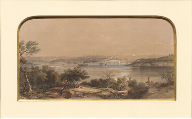
Print, Conrad MARTENS, View of Sydney. NSW, 1855
Born: London, England 1801; Arrived: Sydney, New South Wales, Australia 1835; Died: Sydney, New South Wales, Australia 1878ColonialBennett Bequest, 1999 Hand-coloured lithograph depicting industrial waterscape with rocky shoreline and ships and buildings in background. Black painted timber frame with off white arched window mount and gold brushed internal window edgeRecto: Not signed, not dated, not titled print, waterscape, sea, harbour, land, figures, boats, tress, sydney harbour, buildings -
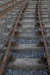 Puffing Billy Railway
Double Headed Rail, circa 1872 - 1883
Double Headed Rail from Ravenswood Station Siding which was dismantled circa 1987 the two rails were stored for a time at Maldon before being donated to Puffing Billy Museum Bearing makers marks of Wilson & Cammell - Dronfield- Steel works Wilson & Cammell made Steel rails at their Dronfield Steel Works, in Dronfield, North East Derbyshire, England from 1872 - 1883 Double-headed rail In late 1830s Britain, railway lines had a vast range of different patterns. One of the earliest lines to use double-headed rail was the London and Birmingham Railway, which had offered a prize for the best design. This rail was supported by chairs and the head and foot of the rail had the same profile. The supposed advantage was that, when the head became worn, the rail could be turned over and re-used. In practice, this form of recycling was not very successful as the chair caused dents in the lower surface, and double-headed rail evolved into bullhead rail in which the head was more substantial than the foot. Info from Wikipedia - Rail Profile https://en.wikipedia.org/wiki/Rail_profile The first records of double headed rail being used In Victoria by Victorian Railways was in 1859, the rails, chairs, oak and trenails were imported from UK. After the 1870’s the Victorian Railways went over to using flat bottom rails, but they still needed replacement double headed rail for lines already laid and this continued up to at least 1883 Wilson & Cammell - Dronfield- Steel works Wilson & Cammell made Steel rails at their Dronfield Steel Works, in Dronfield England from 1872 - 1883 Mount Alexander & Murray River Railway The Melbourne, Mount Alexander & Murray River Railway Company received parliamentary assent in February 1853 to build Victoria's first inland railway from Melbourne to Williamstown, and Melbourne to Bendigo and Echuca. Construction commenced in January 1854 with work on a pier at Williamstown but lack of funds slowed progress, eventually prompting the company to sell out to the government. The 100-mile (162 km) section to Bendigo opened in October 1862. Its cost of £35,000 per mile made it the most expensive railway ever built in Australia. In 1864, the line was extended to Echuca, tapping into the booming Murray-Darling paddlesteamer trade. info from Museums Victoria - Victorian Railways https://museumsvictoria.com.au/railways/theme.aspx?lvl=3&IRN=450&gall=456 1863 Ravenswood Station open on the 1st Feb 1863 Victorian Railways - purchased and imported the Rail and Chairs from Raleigh, Dalgleish, White and Co. London Importation of railway plant : abstract of a return to an order of the Legislative Assembly dated 27th June 1860 for - Copies of the advertisements calling for tenders, the names of the tenderers and the accounts and correspondence with Mr Brunel relating thereto GP V 1859/60 no. C 15 http://www.parliament.vic.gov.au/papers/govpub/VPARL1859-60NoC15.pdf Report from the Select Committee upon the Importation of Railway Plant : together with proceedings of the Committee, minutes of evidence and appendix GP V 1859/60 no. D 38 (2.9 MB) http://www.parliament.vic.gov.au/papers/govpub/VPARL1859-60NoD38.pdf Ravenswood Siding When the Victorian Railways were established in 1856 they adopted one of the popular British permanent way standards - heavy 80lb (36.3kg) double-headed rail held up right in cast iron chairs attached to transverse timber sleepers by wooden pegs called trenails. The Ravenswood Railway siding was constructed in 1862 with 12 feet wrought iron double-head rail held in cast iron chairs with Ransom and May patent compressed keys. Trenails held the chairs to the sleepers and the joints were secured in joint chairs. Joints were subsequently joined using fish plates. It formed part of the Melbourne to Echuca rail line, initially known as the Melbourne, Mt Alexander and Murray River Railway. George Christian Derbyshire, the first Engineer-in-Chair of the Victorian Railways was responsible for the design and construction of the works. No new lines were built in Victoria using double-headed rail after 1870. The siding was disconnected from the main line in 1988. The Ravenswood Railway Siding demonstrates the original 1856 philosophy of the Victorian Railways to adopt British permanent way technology. The siding demonstrates significant aspects in the development of permanent way technology in England and Victoria over the period from the 1830's to the 1880's. The chairs in the Ravenswood siding are physical evidence of early railway technology rendered obsolete 120 years ago, namely joint chairs at rail joints and trenails to secure the chairs to the sleepers. The double-headed rail demonstrates an important stage in the evolution of British rail technology in the 1830s. The old fish plates, square headed bolts and square nuts demonstrate the success of fishing the rail joins. The Ravenswood siding demonstrates the earliest form of rail joint technology developed in England, and existing in Australia, the joint chair. In part of the siding the sequence of joint and intermediate chairs is consistent with the 1856 specifications, that sequence is rare with the joints secured in joint chairs. The survival of chairs in this sequence is rare and almost certainly demonstrates that they remained in continuous use at the same location from 1862 to 1988. This remnant of the Ravenswood siding has survived 126 years. The siding has proved to be the most significant of extant remnant double-headed sidings in Victoria, containing a rare combination of early permanent way technologies. Construction dates 1862, Info from Ravenswood Railway Siding Victorian Heritage Database Report http://vhd.heritagecouncil.vic.gov.au/places/4693/download-report The remaining section of this siding is significant at the State and National levels in that it demonstrates the use of chaired rail by the Victorian Railways Department for the Trunk Lines and, more particularly, the following stages in the evolution of this long obsolete method of permanent way construction: a) The use of joint chairs and intermediate chairs at regular intervals inferring that the original wrought iron rail lengths were 12 feet, as is known through documentary sources to have been the case. The survival of chairs in this sequence is unique and almost certainly demonstrates that they have remained in continuous use at the same location and in the same sequence from 1862 to 1988 . b) The use of joint chairs and intermediate chairs designed for use with trenails. c) The use of later intermediate chairs designed for use with steel pins and the use of fished joints with steel double head chaired rail, representing a second method of constructing the permanent way using chaired rail technology. info from Ravenswood Siding - Melbourne/Echuca Railway Line - Victorian Heritage Database Report http://vhd.heritagecouncil.vic.gov.au/places/70103/download-report Addition to Citation for Melbourne to EchucaRailway Line 1/10/1990 Double Head Rail The surviving lengths of double head rail with chairs on this railway compare with one surviving similar remnant on the Geelong to Ballarat railway and are representative of permanent way construction techniques applied exclusively to the two trunk railways of the 1860's. In this respect they are rare survivors and may be unique at the national level and of technical importance at the international level to the extent that they enhance contemporary understanding of early railway building technology. Surviving lengths of chaired double head rail survive at Kyneton, Ravenswood and Bendigo on this railway and include a number of different types of cast iron intermediate and joint chairs with hardwood keys and metal pins. The Ravenswood siding is of special significance for the diversity of chair types and for the sequence of chairs recalling rail lengths known to be associated with construction of the line in 1862. Construction of the Railway Tenders closed on 24 March 1858 with no less than 133 tenders being received. A contract was let to Cornish and Bruce for £3,356,937 to commence work on 1 June 1858 and complete the line by 31 July 1861. Cornish and Bruce made quick early progress with the Melbourne to Sunbury section being officially opened on 13 January 1859. The line was officially opened to Bendigo (Sandhurst) on 20 October 1862 by the Governor of Victoria, Sir Henry Barkly. A great banquet was held for 800 guests and this was followed by a grand ball. The extension of the line to Echuca was a relatively simple matter as that part of the line was across plain country without any significant engineering challenges. Tenders were called for the work in 1863 and the work was completed in 1864 by contractors Collier and Barry Apart from the line contractors, other firms directly involved were J Shire law and Co (sleepers), R Fulton, Langlands Brothers and Co, William Crossley (water supply), B Moreland, Langlands Brothers and Co (platelayers lorries), E Chambers (iron pins, traversers), Miller and McQuinstan (luggage vans and steam engines) and various contractors for building works. Info from Engineers Australia Engineering Heritage Victoria Nomination for Recognition under the Engineering Heritage Australia Heritage Recognition Program for the Goldfields Railways - Melbourne , Bendigo & Echuca Railway Page 25 - .2.9.2 Statement from National Trust of Australia (Victoria) Listing number B5323 for Mt Alexander/Murray Valley Rail Line: Page 69 - Theme 3 https://www.engineersaustralia.org.au/portal/system/files/engineering-heritage-australia/nomination-title/Melbourne_%20Bendigo_Echuca%20Railway%20Nomination.pdf The Melbourne, Mount Alexander and Murray River Railway Company was a railway company in Victoria, Australia. It was established on 8 February 1853 to build a railway from Melbourne to Echuca on the Victorian-NSW border and a branch railway to Williamstown. The company struggled to make any progress and on 23 May 1856, the colonial Government took over the Company and it became part of the newly established Department of Railways, part of the Board of Land and Works. The Department of Railways became Victorian Railways in 1859. Construction of the Bendigo line commenced in 1858, but this private consortium also met with financial difficulties when it was unable to raise sufficient funds, and was bought out by the Victorian colonial government. The design work was then taken over by Captain Andrew Clarke, R. E., Surveyor-General of Victoria, with bridge designs completed by Bryson and O'Hara The contract for the first stage of the line from Footscray to Sandhurst (now Bendigo), was let to Cornish and Bruce for £3,356,937.2s.2d ($6.714 million) with work commencing on 1 June 1858. Completion of the permanent way was to be by 31 July 1861 https://en.wikipedia.org/wiki/Melbourne,_Mount_Alexander_and_Murray_River_Railway_Company Victorian Railways - purchased and imported the Rail and Chairs from Raleigh, Dalgleish, White and Co. London Importation of railway plant : abstract of a return to an order of the Legislative Assembly dated 27th June 1860 for - Copies of the advertisements calling for tenders, the names of the tenderers and the accounts and correspondence with Mr Brunel relating thereto GP V 1859/60 no. C 15 http://www.parliament.vic.gov.au/papers/govpub/VPARL1859-60NoC15.pdf Report from the Select Committee upon the Importation of Railway Plant : together with proceedings of the Committee, minutes of evidence and appendix GP V 1859/60 no. D 38 (2.9 MB) http://www.parliament.vic.gov.au/papers/govpub/VPARL1859-60NoD38.pdf Victorian Railways : report of the Board of Land and Works November 1862 GP V 1862/63 no. 21 (2.8 MB) https://www.parliament.vic.gov.au/papers/govpub/VPARL1862-63No21.pdfHistoric - Victorian Railways - Double Headed rail Ravenswood Railway Station and Siding Victorian Heritage Database Reports Victorian Heritage Register VHR H1100 Victorian Heritage Register VHR H1786 National Trust VHR H1100 Mount Alexander and Murray River Rail way Line National Trust2 rail lengths of Double Headed Rail made of Iron makers marks : Wilson & Cammell - Dronfield - Steel and 20 joint chairs with metal rail pins Makers mark Wilson & Cammell - Dronfield - Steel (possible date 187? very hard to read ) puffing billy, double headed rail, wilson & cammell - dronfield - steel works, ravenswood station siding, melbourne to echuca rail line, initially known as the melbourne, mt alexander and murray river railway. -
 Robin Boyd Foundation
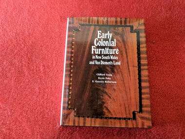
Book, Clifford Craig, Kevin Fahy, E Graeme Robertson, Early Colonial Furniture in New South Wales and Van Diemen's Land, 1972
Hardcover w/ Dust Jacketwalsh st library -
 Koorie Heritage Trust
Book, Pybus, Cassandra, Community of thieves, 1992
In 1892 Richard Pybus took up a large land grant on Bruny Island, the traditional home of the Nuenone people of south-east Tasmania. Within months of his arrival there were no Nuenone left on the island - they had either died from disease, or been murdered or exiled. Truganini, the last of the Nuenone, died in 1876, having spent her adult life in exile as a dependent of the colonial government. Describes sealers use of Tasmanian women and Robinson's Port Phillip expedition.xiv, 198 p., [2] leaves. : ill., maps & ports. ; references; appendix; 20 cm.In 1892 Richard Pybus took up a large land grant on Bruny Island, the traditional home of the Nuenone people of south-east Tasmania. Within months of his arrival there were no Nuenone left on the island - they had either died from disease, or been murdered or exiled. Truganini, the last of the Nuenone, died in 1876, having spent her adult life in exile as a dependent of the colonial government. Describes sealers use of Tasmanian women and Robinson's Port Phillip expedition.truganini, 1812?-1876. | aboriginal tasmanians -- tasmania -- bruny island -- history -- 19th century. | nuenone (australian people) -- tasmania -- bruny island -- history -- 19th century. -
Koorie Heritage Trust
Book, Broome, Richard, Arriving, 1984
Tells the story of immigrants, from settlement at Port Phillip to date. It also describes the interaction with the Aboriginal people who were already here it spans 50,00 years. First chapter of each volume is an overview of traditional life at the time of contact concentrating on Aboriginal economic life altering/?managing of environment, with discussions of original population estimates and extent of decimation due to; disease in colonial times - smallpox, V.D., Aboriginal and white attitudes, friendships/?violent conflict, continued depopulation, missions/?reserves - 19th/?20th cent. incldg Lake Tyers, contemporary Aboriginal identity, welfare/?land rights programs.v-xiv; 258 P.; : ill. (some col.). ; maps; figs.; notes; index; 26 cm.Tells the story of immigrants, from settlement at Port Phillip to date. It also describes the interaction with the Aboriginal people who were already here it spans 50,00 years. First chapter of each volume is an overview of traditional life at the time of contact concentrating on Aboriginal economic life altering/?managing of environment, with discussions of original population estimates and extent of decimation due to; disease in colonial times - smallpox, V.D., Aboriginal and white attitudes, friendships/?violent conflict, continued depopulation, missions/?reserves - 19th/?20th cent. incldg Lake Tyers, contemporary Aboriginal identity, welfare/?land rights programs.social identity - aboriginality. | religions - christianity - missions. | settlement and contacts - colonisation - 1788-1850. | daily life. | demography - population dynamics. | government policy - integration. | government policy - state and territory - victoria. | health - infectious diseases - smallpox. | land rights. | socioeconomic conditions - living conditions. | race relations - violent - massacres, murders, poisonings etc. - to 1900. | race relations - racism - stereotyping. | reproduction. | technology. | bung yarnda /? lake tyers (e vic gippsland sj55-07) victoria. | victoria -- history. -
Unions Ballarat
Eureka : The songs that made Australia, 31 cm
Songs of Australian heritage for voice. Melody line only with chord symbols. Includes guitar tablature for chords. Convicts, transportation and sea shanties. Pioneering, goldrush days and bushrangers. Shearers, drovers and bush life. Swagmen, Victorian expansion, sporting life and disasters. Contents: • According to the Act • The Albury ram • Another fall of rain • Australia's on the Wallaby • The bald-headed end of the broom • The ballad of Ben Hall • The ballad of the Kelly Gang • The banks of the Condamine • The big-gun shearer • The black velvet band • The blackboys Waltzing Matilda • Bluey Brink • Bold Jack Donohue • Bound for Botany Bay • Brisbane ladies • Cain killed Abel • The cane-cutter's lament • The carrier's song • The Catalpa • Charlie Mopps • Click go the shears • The cockies of Bungaree • Colonial experience • Coming down the flat • The convict maid • The currency lasses • The death of Alec Robertson • The death of Ben Hall • The death of Willie Stone • Denis O'Reilly • The drover's dream • The dying aviator • The dying stockman • Eight little cylinders • The Eldorado mining disaster • The exile of Erin • Farewell to Greta • Flash Jack from Gundagai • The flash stockman • Frank Gardiner • The freehold on the plain • The gaol song • The girls of the Shamrock Shores • The golden gullies of the Palmer • The gumtree canoe • The Hamfat man • Heenan and Sayers • Henry's downfall • Here's adieu to all judges and juries • I've been to Australia, Oh • Jim Jones at Botany Bay • Jog along til shearing • John Kanaka • The Lachlan Tigers • Leave her, jollies, leave her • Les Darcy • The limejuice tub • Look out below • Maggie May • Maids of Australia • Man of the Earth • The Maryborough miner • Moreton Bay • The morning of the fray • Morrisey and the Russian sailor • Musselman • The mustering song • My name is Edward Kelly • Nails • The new chum Chinaman • Nine miles from Gundagai • The nose on my old man • Oh, give me a hut • The old bark hut • The old bullock dray • One of the has-beens • The overlanders • Pint Pot and Billy • Pity poor labourers • Radcliffe Highway • The rigs of the time • Rolling home • The Ryebuck shearer • Sam Holt • Sign-on day • Sixteen thousand miles from home • South Australia • The springtime it brings on the shearing • The stockman's last bed • The Sunshine Railway disaster • Tambaroora Ted • The tattooed lady • Ten thousand miles away • The tent poles are rotten • Travelling down the Castlereagh • Tumba-bloody-Rumba • The two professional hums • Van Diemen's Land • The wallaby brigade • When we get our tuppence back • The wild colonial boy • Woolloomooloo Australian culture, folklore and history in songs.Paper; paperback book. Front cover: multicoloured background; picture of swaggy with guitar; picture of Eureka flag; black and green lettering. Back cover: red, orange and white background; Eureka flag; picture of a shearer with sheep; picture of a person in Ned Kelly armour playing a guitar on a horse; picture of woman facing the Ned Kelly figure; brand with the message "unsurpassed Australian made".Front cover: author's name and title. Back cover: author bio; praise from Jack Pobar, swagman.songs, btlc, ballarat trades and labour council, ballarat trades hall, convicts, transportation, sea shanties, pioneering, gold, goldrush, bushrangers, shearers, drovers, bush life, sporting life, disasters, music -
 Bayside Gallery - Bayside City Council Art & Heritage Collection
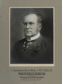
Photograph - gelatin silver photograph, Jonathan Binns Were, c. 1880
Jonathan Binns Were (1809-1885) was born in Somerset, England on 25 April 1809. Before he migrated to Australia in 1839, he worked with colonial merchants and bankers Collins & Co. in Plymouth. Initially trading under his own name, he formed Were & Co. with his brother George and his brother-in-law, Robert Stevenson Dunsford, then, after 1861, JB Were & Son. Were’s were importers, exporters and agents for shipping, land, cattle, sheep and wool; gold brokers and buyers (after 1851); and share dealers (after 1853). Were went bankrupt twice in 1843 and 1857, the former connected with his association with Henry Dendy and the Brighton subdivision. Were lived in Brighton at Moorabbin House and represented Brighton in the Legislative Assembly in 1856-57. In 1865 Were became the first chairman of the Melbourne Stock Exchange; he was the first president of the Chamber of Commerce and served on the board of many public and private institutions and companies. He was Port Phillip’s first Justice of the Peace; and organiser of the 1881 Melbourne Exhibition. He was knighted by the Kings of Sweden and Denmark.portrait, j.b. were, jonathan binns were, merchant, policitian, melbourne stock exchange, justice of the peace, victorian legislative assembly, stockbroker, c.m.c, m.l.a., j.p., a. bonville were -
![Glimpses of Life in Victoria / [by] a 'Resident'](/media/collectors/550653872162f11fb04854aa/items/5ed05546dcf9cd08346c11f9/item-media/5ed055fedcf9cd08346c1974/item-fit-380x285.jpg) Kew Historical Society Inc
Kew Historical Society IncBook, Melbourne University Press, Glimpses of Life in Victoria, 1996
An account of pioneering, bushrangers, gold-digging, land sales and swindles, the aborigines, and colonial society.xxxii, 322 p. : illus. (some col.)An account of pioneering, bushrangers, gold-digging, land sales and swindles, the aborigines, and colonial society.melbourne (vic.) -- description and travel., victoria -- social life and customs -- 1834-1900. -
 Kew Historical Society Inc
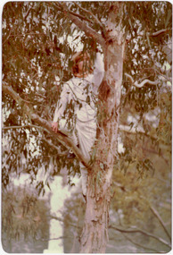
Photograph - Historic re-enactment during the Festival of Kew, 1978
At the 1978 Festival of Kew, a number of organisations, including the City of Kew, the Kew Historical Society, Trinity Boys Grammar School and local Girl Guides participated in a re-enactment of the expedition of the party of Charles Grimes in surveying the Yarra River as far as Kew in February 1803. The location for the event was Yarra Bend Park near the Studley Park Boat House. The event was organised by the Kew Historical Society. The re-enactment was captured by a number of amateur photographers as well as by a photographer from the local Progress Press.Local communities select events to commemorate according to their shared history and values. Commemorations of colonial exploration were popular with local historical groups such as the Kew Historical Society in the twentieth century. In re-enacting events such as the Grimes survey of the Yarra, students from a local school were encouraged to take on specific roles, including play-acting individuals involved in the survey party as well as members of the local Wurundjeri People. The photographs, taken by amateur and professional photographers, represent a period in time when the dominant values were those shared by the descendants of European settlers in Victoria. Original colour photographic positive showing a boy from Trinity Grammar School in a tree, role-playing Captain Robbins, a member of Grimes' survey party.Annotated on reverse: "CAPTAIN ROBBINS LOOKING UP THE YARRA AND REPORTING: 'A LAND THAT OFFERS GREAT OPPORTUNITY FOR SETTLEMENT' / RE-ENACTED BY A TRINITY BOY / 1978 FESTIVAL"kew historical society, trinity grammar school, kew girl guides, city of kew, yarra river, charles grimes, collins expedition, wurundjeri people, yarra bend park, colonial surveys, historic re-enactments, festival of kew, kew festival -
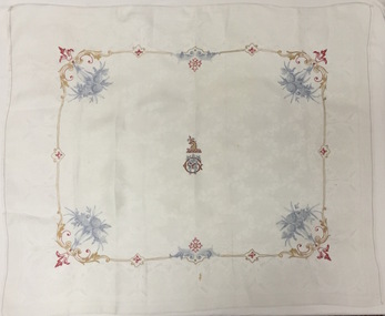 Kew Historical Society Inc
Textile, Damask Tablecloth embroidered with the Greenlaw Crest, 1882-1890
When the newly married William and Anna Maria Greenlaw acquired the property in 1862, an existing house known as Studley Villa stood on the land. John Hodgson probably built the latter soon after he bought three portions of land here in 1853. The Greenlaws changed the name of the residence to Villa Alba in about 1870 and in 1882-84 rebuilt the house to create the present mansion. After William Greenlaw’s death in 1895, John Ballinger rented the house until 1914. The lease then passed to Samuel and Esther Fripp, who went on to purchase the property in 1918 after Anna Maria Greenlaw’s death in 1918.This rare textile is associated with the most significant period of Villa Alba's history and is an example of the colonial aspirations of its citizens in the boom years of the 1880s before the crash that engulfed the owner.Small white damask tablecloth or napkin embroidered with the crest of William Greenlaw, the owner of Villa Alba in Walmer Street, Kew. The embroidery of the crest and borders of garlands are completed in multicoloured silk thread.Greenlaw crest - griffin holding thistle in beak over initials WGvilla alba, william greenlaw, tablecloths -
 Kew Historical Society Inc
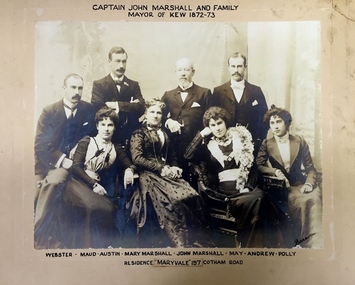
Photograph - Family Portrait, Captain John Marshall and Family, Mayor of Kew 1872-73, 1890s
Captain John Marshall was born in Dundee, Scotland c.1833. Within eleven years of his arrival in Melbourne in 1852, he had established an important colonial shipping company, Anderson & Marshall, and married Mary Austin, the eldest daughter of Thomas Austin Esq of Clifton Villa in Cotham Road. Elected to the Kew Borough Council in 1869, he remained an active member until 1875. During this period, he was elected Mayor of Kew in 1872. A Scottish Protestant by birth and conviction, John Marshall was, with David Beath, a member of the inaugural committee that began planning for a separate Presbyterian Church in Kew, lending the Committee the funds to purchase land on the corner of Cotham Road and Highbury Grove. John Marshall lived at his home, 'Maryfield', at what was then 239 [now 197] Cotham Road until shortly before his death at the age of 70 in January 1903. He was buried on 14 January in Grave 493, Presbyterian Compartment A, Boroondara General Cemetery.Family portrait of an important civic figure in Kew in the 19th century who was also a notable businessman and shipowner in the Colony of Victoria.Albumen Silver photograph on card of Captain John Marshall and family, Mayor of Kew 1872-73.The inscription was added by the family and at one stage modified. In addition to the title, the sitters' names are inscribed beneath the photograph on the mountCaptain John Marshall and family / Mayor of Kew 1872-73 Webster - Maud - Austin - Mary Marshall - John Marshall - May - Andrew - Polly / Residence “Maryvale” 197 Cotham Road. john marshall, maryvale (cotham road, kew), maryfield (cotham road, kew), webster marshall, maud marshall, austin marshall, mary marshall, may marshall, andrew marshall, polly marshall -
 Kew Historical Society Inc
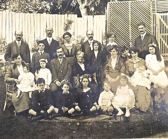
Photograph - Family portrait, The Marshall Family, 1903-1914
Captain John Marshall was born in Dundee, Scotland c.1833. Within eleven years of his arrival in Melbourne in 1852, he had established an important colonial shipping company, Anderson & Marshall, and married Mary Austin, the eldest daughter of Thomas Austin Esq of Clifton Villa in Cotham Road. Elected to the Kew Borough Council in 1869, he remained an active member until 1875. During this period, he was elected Mayor of Kew in 1872. A Scottish Protestant by birth and conviction, John Marshall was, with David Beath, a member of the inaugural committee that began planning for a separate Presbyterian Church in Kew, lending the Committee the funds to purchase land on the corner of Cotham Road and Highbury Grove. John Marshall lived at his home, 'Maryfield', at what was then 239 [now 197] Cotham Road until shortly before his death at the age of 70 in January 1903. He was buried on 14 January in Grave 493, Presbyterian Compartment A, Boroondara General Cemetery.Family portrait of the relatives of an important civic figure in Kew in the 19th century who was also a notable businessman and shipowner in the Colony of Victoria.Albumen silver photograph on card of the Marshall family grouped in three rows in a garden setting. The twenty-three members of the extended family do not include John Marshall so the photograph presumably dates from after his death in 1903. His wife, Mary Marshall, is in the middle row, five from left. marshall family, john marshall -- mayor of kew -
 Mrs Aeneas Gunn Memorial Library
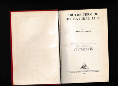
Book, Home Entertainment Library, For the term of his natural life, 1935
A novel of colonial prison life in Van Diemens Landp.494.fictionA novel of colonial prison life in Van Diemens Landaustralia - fiction, australia - convict system -
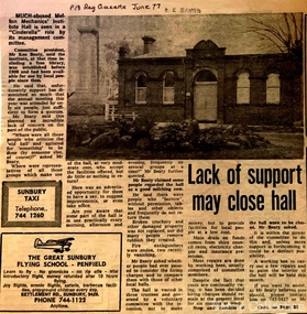 Melton City Libraries
Newspaper, Lack of support may close hall, 1977
"The Mechanics Institute movement flourished in Victoria from 1839 to 1950. It was based on the development of Mechanics’ Institutes in Scotland and England from the 1820s, which were intended to educate and enlighten the working classes. The term ‘mechanic’ in those days meant an artisan, craftsman or working man, especially those who had moved from rural areas to work in new city factories during the Industrial Revolution. The early Institutes were usually equipped with a reading room, a library and a lecture room. Although enjoying mixed success in Britain, they contributed to the development of public education and library services. The movement was adopted more enthusiastically in the colonies. It began slowly in Victoria but its expansion after the gold rushes population influx was rapid, especially in rural areas. Every suburb and town wanted to have a Mechanics’ Institute. During the 1850s approximately forty Institutes were established, with even greater growth in the period 1860 to 1900. By 1900 there were 400 Institutes in Victoria. The establishment of a Mechanics’ Institute was often a great achievement for a local community, requiring organising committees to raise substantial funds for a building site (where this had not been granted by the Government), and the building. Once built, the committee then had to purchase books, provide a caretaker or librarian, and finance the ongoing use of and improvements to the building. ‘The history of many Institutes is a story of tremendous community effort, and often, financial difficulties’. In addition to being monuments to local enterprise and community life, the Mechanics’ Institutes played a vital role as an intellectual forum, and in contributing to an informed and participatory democracy in the late nineteenth and early twentieth centuries. They provided journals and other reading matter on local, state, national and international issues, and hosted of lectures and held debates about wider issues such as Federation, colonial nationalism, defence, female suffrage, the price of land and labour. With the development of the school and technical education in the latter part of the nineteenth century, the need for community technical and adult education declined. As a result of the introduction of government library grants in 1867, many Mechanics’ Institutes incorporated a free library in their buildings to finance collection of their books. By 1884-85, there were 257 free libraries in Victoria. However, government support and library grants dropped off in the 1890s depression. Entertainment took on a greater role in the 1890s, with the introduction of moving pictures, billiards rooms, games rooms (chess), concerts and dances. The First World War had a devastating impact on many rural communities, and some Mechanics’ Institutes were no longer viable. On the other hand the early twentieth century was also a time of agricultural development, and many country towns were growing in this period. The 1930s depression further limited growth of many libraries and reduced grants substantially. In response many Mechanics’ Institutes were renamed, for example as memorial halls, in order to retain and attract more patrons (eg at nearby Sunbury). The diminishing role for Mechanics’ Institutes and the preference for larger and better appointed halls (with supper rooms, cloak rooms etc) resulted in demolition of some small Institutes. The advent of cars, radios, and television also provided other opportunities for recreation, learning and entertainment. The greater role of municipalities in providing library services also eroded the need for free libraries. While over 500 Mechanics’ Institutes or halls are extant, very few of these retain their original role as ‘diffusers of useful knowledge’. Most are still available for community purposes, as venues for meetings, socials, civic occasions etc, while others are employed as museums, shops and theatres. Most buildings are on Crown land, and managed by a delegated committee of management, who are responsible for raising revenue to maintain aging buildings. Many of those which were originally established on private land, such as Melton, have since reverted back to the Crown, and municipal Councils. The most common Mechanics Institute building form is the simple weatherboard gable building with iron roofs, notable for their ‘honest simplicity’ rather than as ‘monuments of the ancients’. At the other extreme there are some magnificent two storeyed brick and stucco structures with elaborate ornamentation (as was apparently envisaged by some in Melton in 1905-10)". The future of Melton Mechanic Institute Gazette articlelocal architecture -
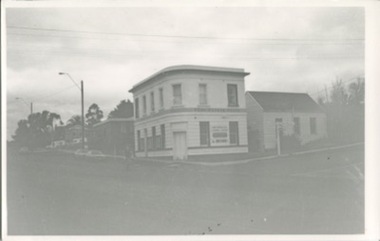 Kilmore Historical Society
Photograph, Real Estate House, c1970
The building was originally the Colonial Bank of Australasia and has a series of occupants, include a real estate firm in the 1970's20cm x 10cm black and white photograph of 1 Powlett street, former colonial bank of Australasia. corner of Powlett Street and Lancefield Road. Two story light coloured rendered building with signage for "Real Estate House" on top of the ground floor. Other signage painted on the Lancefield Road side of the building include: "Land specialists to Kilmore & district". The building also has an adjoining cottage on the Lancefield Road side of the property. There is also a figure crossing the road and five vehicles in the background of the photograph, three regular vehicles and two possible emergency service vehicles. A street sign can be seen pointing to: Lancefield, Kyneton, Foote Street, Melbourne and Seymour.PHO-00003banks and banking, real estate agents -
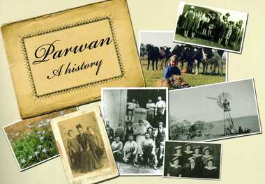 Bacchus Marsh & District Historical Society
Book, Parwan: A History, 2010
Explores the history of the small farming community on the outskirts of Bacchus Marsh. It contains a plethora of fascinating details about the early years of this farming community from the 1830s until the early 2000s. There is a brief section at the beginning which looks at the history of the area prior to the colonial era. The book contains numerous sections about families and individual people who have lived in the Parwan area and includes many images of places and people. Citation: Parwan: A History by Dianne Van Leuvan. Published by Parwan History Group, Bacchus Marsh, Vic., 2010.Paperback printed book. 128 pages. with illustrations and photographs, some coloured. Includes facsimiles, maps, and index. Includes a separate folded sheet inside a pocket which has a reproduction of a map of the Parwan Parish in the County of Grant. On the reverse of this sheet are two reproductions. One is a land auction plan for February 1910 advertising the sale of portions of land from the Nerowie Estate. The other reproduction is a section of a map showing some of the blocks of land in the Nerowie Estate which has the heading, 'Nerowie Titles 1898'. A pocket inside the back cover contains a separate booklet which is an index, and two pages of 'Additional Information'.non-fictionExplores the history of the small farming community on the outskirts of Bacchus Marsh. It contains a plethora of fascinating details about the early years of this farming community from the 1830s until the early 2000s. There is a brief section at the beginning which looks at the history of the area prior to the colonial era. The book contains numerous sections about families and individual people who have lived in the Parwan area and includes many images of places and people. Citation: Parwan: A History by Dianne Van Leuvan. Published by Parwan History Group, Bacchus Marsh, Vic., 2010.parwan vic. history -
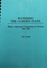 Wodonga & District Historical Society Inc
Book - Watering the Garden State - Water, Land and Community in Victoria 1834-1988, J.M. Powell
This publication traces the importance of water resources to Australian society, with reference to the state of Victoria. It relates the history from 1834 including topics such as community adaptation to settlement planning for squatters, miners, immigrants and colonials; conservation and water management; expansion and consolidation of statutory bodies following the creation of the Department of Water Resources in 1984; and finally the effects of regionalism, environmentalism, urban conflict and institutional reform. It includes an appendix containing a brief chronology of significant events regarding water from 1853 to 1987.Spiral bound booklet with laminated covernon-fiction This publication traces the importance of water resources to Australian society, with reference to the state of Victoria. It relates the history from 1834 including topics such as community adaptation to settlement planning for squatters, miners, immigrants and colonials; conservation and water management; expansion and consolidation of statutory bodies following the creation of the Department of Water Resources in 1984; and finally the effects of regionalism, environmentalism, urban conflict and institutional reform. It includes an appendix containing a brief chronology of significant events regarding water from 1853 to 1987.water resources development, water-supply -- victoria -- history., water victoria -
 City of Kingston
Photograph - Colour, Paul Tresize, 1998
The name Mordialloc was derived from the name Moody Yallock, which comes from the Bunurong language. The Bunurong Peoples are the Traditional Owners of this area. The name means “high water” or “high creek”. In 1839, colonial authorities declared the mouth of the creek, and an additional 830 odd acres as an Aboriginal Reserve, although this proclamation was never gazetted. The reserved land included part of the Carrum Carrum Swamp which was abundant with wild life and natural resources. Regular encroachments, including land sales which began in 1863, were made on the land until 1878 when the Reserve was declared closed, and the land was opened up to land sales. Market gardening and suburban house lots quickly began to develop, and Mordialloc became a renowned picnic and holiday site. Mordialloc Creek is a popular bay side destination for local and visitors, and is a site for boating, kayaking, fishing and swimming, along with many other activities.Colour photograph of Mordialloc Creek, looking out to the bay. Many small fishing and leisure craft are moored on either side of the banks of the creek. To the right hand side can be seen parklands, while the left hand side has a small inlet in which more small crafts are moored.mordialloc, bunurong, traditional owners, suburbs, boats, fishing, waterways -
 City of Kingston
Photograph - Colour, 1998
The name Mordialloc was derived from the name Moody Yallock, which comes from the Bunurong language. The Bunurong Peoples are the Traditional Owners of this area. The name means “high water” or “high creek”. In 1839, colonial authorities declared the mouth of the creek, and an additional 830 odd acres as an Aboriginal Reserve, although this proclamation was never gazetted. The reserved land included part of the Carrum Carrum Swamp which was abundant with wild life and natural resources. Regular encroachments, including land sales which began in 1863, were made on the land until 1878 when the Reserve was declared closed, and the land was opened up to land sales. Market gardening and suburban house lots quickly began to develop, and Mordialloc became a renowned picnic and holiday site. Mordialloc Creek is a popular bay side destination for local and visitors, and is a site for boating, kayaking, fishing and swimming, along with many other activities.Colour photograph of Mordialloc Creek, looking inland.Small fishing and leisure boats are moored on either side of creek, with a view of the Mordialloc Bridge Hotel in the background.mordialloc, bunurong, traditional owners, suburbs, boats, fishing, waterways, hotel -
City of Kingston
Photograph - Colour, Paul Tresize, 1998
The name Mordialloc was derived from the name Moody Yallock, which comes from the Bunurong language. The Bunurong Peoples are the Traditional Owners of this area. The name means “high water” or “high creek”. In 1839, colonial authorities declared the mouth of the creek, and an additional 830 odd acres as an Aboriginal Reserve, although this proclamation was never gazetted. The reserved land included part of the Carrum Carrum Swamp which was abundant with wild life and natural resources. Regular encroachments, including land sales which began in 1863, were made on the land until 1878 when the Reserve was declared closed, and the land was opened up to land sales. Market gardening and suburban house lots quickly began to develop, and Mordialloc became a renowned picnic and holiday site. Mordialloc Creek is a popular bay side destination for local and visitors, and is a site for boating, kayaking, fishing and swimming, along with many other activities.Colour photograph of Mordialloc Creek, looking inland. Boats are moored on either side of the creek and the Bridge Hotel is visible in the background.mordialloc, bunurong, traditional owners, suburbs, boats, fishing, waterways, hotel -
 City of Kingston
Photograph - Colour, Paul Tresize, 1998
The name Mordialloc was derived from the name Moody Yallock, which comes from the Bunurong language. The Bunurong Peoples are the Traditional Owners of this area. The name means “high water” or “high creek”. In 1839, colonial authorities declared the mouth of the creek, and an additional 830 odd acres as an Aboriginal Reserve, although this proclamation was never gazetted. The reserved land included part of the Carrum Carrum Swamp which was abundant with wild life and natural resources. Regular encroachments, including land sales which began in 1863, were made on the land until 1878 when the Reserve was declared closed, and the land was opened up to land sales. Market gardening and suburban house lots quickly began to develop, and Mordialloc became a renowned picnic and holiday site. Mordialloc Creek is a popular bay side destination for local and visitors, and is a site for boating, kayaking, fishing and swimming, along with many other activities.Colour photograph of Mordialloc Creek with boats moored on both sides of the street and Pompei's boat yard visible on the right hand side of the creek., Main Street and St Brigid's Catholic Church are visible in backgroundmordialloc, bunurong, traditional owners, suburbs, boats, fishing, waterways, hotel, church -
City of Kingston
Photograph - Colour, Paul Tresize, 1998
The name Mordialloc was derived from the name Moody Yallock, which comes from the Bunurong language. The Bunurong Peoples are the Traditional Owners of this area. The name means “high water” or “high creek”. In 1839, colonial authorities declared the mouth of the creek, and an additional 830 odd acres as an Aboriginal Reserve, although this proclamation was never gazetted. The reserved land included part of the Carrum Carrum Swamp which was abundant with wild life and natural resources. Regular encroachments, including land sales which began in 1863, were made on the land until 1878 when the Reserve was declared closed, and the land was opened up to land sales. Market gardening and suburban house lots quickly began to develop, and Mordialloc became a renowned picnic and holiday site. Mordialloc Creek is a popular bay side destination for local and visitors, and is a site for boating, kayaking, fishing and swimming, along with many other activities.Colour photograph of Mordialloc Creek with boats moored on both sides of the street and Pompei's boat yard visible on the right hand side of the creek., Main Street and St Brigid's Catholic Church are visible in background.mordialloc, bunurong, traditional owners, boats, fishing -
![Map, Plan of Town Allotments Bacchus Marsh [1873]](/media/collectors/5e461d8021ea67224c82f2a1/items/677a8ee7ab7bb47995c5573f/item-media/677a8fdeab7bb47995c55b56/item-fit-380x285.jpg) Bacchus Marsh & District Historical Society
Bacchus Marsh & District Historical SocietyMap, Plan of Town Allotments Bacchus Marsh [1873]
James Young was a prominent businessman, land owner and public figure in the early colonial period of Bacchus Marsh. After his death in 1871 land remaining from his estate in Bacchus Marsh was sold at auction in 1873. The sale of his estate included the substantial stone residence in Bennett Street which later became known as 'Stone Villa'. The sale of his land in 1873 was conducted by local auctioneer James Crook. 29 allotments were advertised for sale, although the plan for the sale indicated 30 allotments. The sale notice in the Bacchus Marsh Express of 11 October 1873 noted that the allotments were " in the very centre and heart of the most populous and business portion of the township, at the same time being the only remaining portion of the business block available for purchase by public sale, which fact intending purchasers should not lose sight of, as the opportunity cannot occur again". The designation of a new street, 'Bennett Street', shown on the plan, is also indicated in the advertising, "In reference to the main street frontages, opposite the Border Flour Mills. The Auctioneer would also direct attention to the plan, showing the formation of a new thorough fare (Bennett street) leading from Young street into Gell street, thus opening up the township on the high, more healthy, and commanding position so much to be desired for private dwellings".An important cartographic document which indicates an early major subdivision of land in the inner urban area of the Bacchus Marsh township. This subdivision lead to the continuing residential and commercial development of the township of Bacchus Marsh in the later part of the 19th century. The location of two well known demolished public structures, the Free Gardeners Hall in Gell Street, and the Old Mechanics Institute Hall (aka the Buffs Hall), on the corner of Young and Bennett Streets, are also shown on this map.A single page paper map showing 30 blocks of land for sale around 1873 in the vicinity of Bennett Street and Lerderderg Street. Described in contemorary sources as a 'lithographed copy'. No scale is indicated. The map is pasted into a bound volume containing 76 maps or plans in total. High resolution digital image stored on BMDHS computer network. land sales bacchus marsh, bacchus marsh victoria maps, james young 1816-1871, bacchus marsh roads and streets, bennett street bacchus marsh -
 Bacchus Marsh & District Historical Society
Map, Plan of Land at Bacchus Marsh, the Property of James Young, 1868
James Young was a prominent businessman, land owner and public figure in the early colonial period of Bacchus Marsh. In February 1868 he offered for sale through the agent W. Anderson 38 blocks of land which ran from the Lerderderg RIver westwards beyond Gisborne Road in the vicinity of the present day Masons Land. The land for sale was described as, 'unsurpassed Agricultural Land, in the immediate vicinity of Bacchus Marsh, varying in size from 2 to 12 acres each'. The sale notice in the Bacchus Marsh Express of 1st February 1868 page 2, also noted that, ' Plans can be seen at Mr. Young's Border Mills Store, and at the Border Inn'. One of the largest and most important land sales in the early colonial period of Bacchus Marsh.A single page paper map showing 38 blocks of land for sale in 1868 in the vicinity of Masons Lane Bacchus Marsh. Scale 11 chains to 1 inch. The map is pasted into a bound volume containing 76 maps or plans in total. High resolution digital image stored on BMDHS computer network. land sales bacchus marsh, bacchus marsh victoria maps, james young 1816-1871, masons lane bacchus marsh land sales -
![Map, Liquidator's sale, 1896. [Woolpack Estate, Bacchus Marsh]](/media/collectors/5e461d8021ea67224c82f2a1/items/6779ee97032b72846b5995f2/item-media/6779ef33032b72846b599b30/item-fit-380x285.jpg) Bacchus Marsh & District Historical Society
Bacchus Marsh & District Historical SocietyMap, Liquidator's sale, 1896. [Woolpack Estate, Bacchus Marsh]
The Woolpack Estate was an area of land owned by various landowners in the Bacchus Marsh area since the early Colonial period of the 1840s. The area was located on the eastern side of the Bacchus Marsh township about 7 kilometers from the town. The Lerderderg River ran through part of the land and so did the Melbourne to Ballarat Road. The historic Woolpack Inn associated with James Crook was also located on this land. By 1896 150 acres of this land was under the control of liquidators for the Federal Bank of Australasia who instructed that the land be sub-divided and sold in lots by public auction. A successful sale was held on 24 June 1896. Most of the blocks of land were sold for higher than expected prices and most of the buyers were people from the town and district of Bacchus Marsh. The map includes various details about the land which is described on the map as an "important sale of rich alluvial irrigable flat land in the Bacchus Marsh Valley, and other properties". The auction was conducted by the local agents W. Anderson and Bence in conjunction with Pearce Brothers also of Bacchus Marsh.A single page paper map showing a plan of 150 acres of land from the Woolpack Estate to be sold in various lots in June 1896. Also shown on the map are lots for sale at Robinson's Farm on Coimadai Creek and allotments near Bacchus Marsh railway station, including lots on Government Road (East Maddingley Road), View Street and Government Road (Parwan Road). No scale provided. The map is pasted into a bound volume containing 76 maps or plans in total. High resolution digital image stored on BMDHS computer network. land sales bacchus marsh, bacchus marsh victoria maps, woolpack estate bacchus marsh victoria -
 Surrey Hills Historical Society Collection
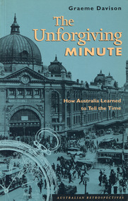
Book - The Unforgiving Minute: How Australia Learned to Tell the Time
Drawing on a wide range of theoretical insights and primary sources, "The Unforgiving Minute" offers an original interpretation of Australian history. It examines time telling from the convict era to the 1990's. As the convict era drew to an end, the colonial governors looked to clocks as the mechanical policemen of an emerging free society. Fifty years later, as railways and telegraphs began to spread across the land, and pocket watches appeared on the waistcoats of working men, colonial society began to keep stricter hours of work and play, and to teach its children the virtue of punctuality. In the early 20th century, punch clocks and time-switches laid the basis for new patterns of work in the factory and the home. Now, in the 1990s, the "faceless clocks" in computers and automated control systems have created a "postmodern" time regime that is both more flexible, and more demanding, than its predecessors.a small book of 21.5 cm; 160pnon-fictionDrawing on a wide range of theoretical insights and primary sources, "The Unforgiving Minute" offers an original interpretation of Australian history. It examines time telling from the convict era to the 1990's. As the convict era drew to an end, the colonial governors looked to clocks as the mechanical policemen of an emerging free society. Fifty years later, as railways and telegraphs began to spread across the land, and pocket watches appeared on the waistcoats of working men, colonial society began to keep stricter hours of work and play, and to teach its children the virtue of punctuality. In the early 20th century, punch clocks and time-switches laid the basis for new patterns of work in the factory and the home. Now, in the 1990s, the "faceless clocks" in computers and automated control systems have created a "postmodern" time regime that is both more flexible, and more demanding, than its predecessors. time measurements -- social aspects -- australia -- history, clocks and watches -- social aspects -- australia -- history, australia -- social conditions, graeme davison -
 Wyndham Art Gallery (Wyndham City Council)
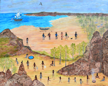
Painting, Marlene Gilson, Waa Waa - Crow Feathers, 2021
Waa Waa – Crow Feathers is a painting from Aunty Marlene Gilson’s 2022 exhibition ‘Bunjil Wour Kun Ya – Spirit of My Ancestors’. This work tells the story of Waa-Waa, the first Wadawurrung to see a white man, Matthew Flinders and his crew surveying the southern Australian coastline near the You Yangs on 1 May 1802. Speaking to Wyndham Art Gallery’s curatorial framework themes of Foregrounding, Habitat and Localism, the work portrays in Wadawurrung lore the first sighting of a European and acknowledges Australian First Nations peoples original and ongoing connections with land, history, politics and knowledges of place. The scene is overlooking the You Yangs which is deeply connected with the local place and habitat of the Werribee Plain. Aunty Marlene Gilson is a Wathaurung (Wadawarrung) Elder living on country in Gordon, near Ballarat. Marlene Gilson’s multi-figure paintings work to overturn the colonial grasp on the past by reclaiming and re-contextualising the representation of historical events. Learning her Wathaurung history from her grandmother, Gilson began painting while recovering from an illness. The artist’s meticulously rendered works display a narrative richness and theatrical quality akin to the traditional genre of history painting. Gilson, however, privileges those stories relating to her ancestral land, which covers Ballarat, Werribee, Geelong, Skipton and the Otway Ranges in Victoria. Often including her two totems, Bunjil the Eagle and Waa the Crow, Gilson’s paintings not only reconfigure historical narratives, but display her spiritual connection to Country. australian first nations art, cultural story, australian painting, wathaurung, female artist