Showing 416 items
matching department of lands and survey
-
 Port Melbourne Historical & Preservation Society
Map - City of Port Melbourne, Department of Lands and Survey, 29 Nov 1938
... Department of Lands and Survey...). 1938 Map City of Port Melbourne Department of Lands and Survey ...Printed map of City of Port Melbourne - Fishermens Bend area and down to Williamstown Road (Kitchens etc). 1938Red pencil marks through existing Lorimer St (refer 306)built environment - industrial, health - general health, fishermans bend, j kitchen & sons pty ltd -
Port Melbourne Historical & Preservation Society
Letter - Department of Lands and Survey grant for improving public parks in Sandridge, Department of Lands and Survey, 19 Oct 1863
... Department of Lands and Survey grant for improving public...Department of Lands and Survey... Department of Lands and Survey ...Handwritten letter from Dept of Lands and Survey 19.10.1863, notifying grant of £90/0/0 for the improving of public parks in Sandridge for 1863local government - borough of sandridge -
Port Melbourne Historical & Preservation Society
Letter - Department of Lands and Survey reply re setting out Sandridge streets, Department of Lands and Survey, 30 Jan 1861
... Department of Lands and Survey reply re setting out...Department of Lands and Survey... Department of Lands and Survey reply re setting out Sandridge streets ...Handwritten letter on blue foolscap laid paper, from Dept of Lands and Survey 13.1.1861 replying to Town Clerk's request on setting out Sandridge streetslocal government - borough of sandridge -
Port Melbourne Historical & Preservation Society
Letter - Department of Lands and Survey re notification of crown grants for Sandridge municipal chambers and market site, Department of Lands and Survey, 20 Jun 1862
... Department of Lands and Survey re notification of crown...Department of Lands and Survey... Letter Department of Lands and Survey re notification of crown ...Handwritten letter on blue foolscap laid paper, from Dept of Lands and Survey 20.6.1862 notifying Town Clerk of two crown grants, for municpal chambers and for market site. Paper watermarked A.Cowan & Sons 1855Notations in pencil on back, upper leftlocal government - borough of sandridge, market reserve, port melbourne town hall -
Port Melbourne Historical & Preservation Society
Letter - Department of Lands and Survey re proclaimation of Beach Street, Sandridge, Department of Lands and Survey, 16 Mar 1861
... Department of Lands and Survey re proclaimation of Beach...Department of Lands and Survey... Department of Lands and Survey ...Handwritten letter on blue foolscap laid paper, from Dept of Lands and Survey 16.3.1861, directing attention to proclamation in Government Gazette re Beech Street (sic) Sandridgelocal government - borough of sandridge, engineering - roads streets lanes and footpaths -
Port Melbourne Historical & Preservation Society
Letter - Department of Lands and Survey re proclaimation for site of Town Hall, Sandridge, Department of Lands and Survey, 30 Dec 1861
... Department of Lands and Survey re proclaimation for site of...Department of Lands and Survey..., watermarked with Britannia symbol Letter Department of Lands ...Handwritten letter on blue foolscap laid paper, from Dept of Lands and Survey 30.12.1861 directing attention to proclamation in Government Gazette re site for Town Hall at Sandridge. Paper, watermarked with Britannia symbollocal government - borough of sandridge, port melbourne town hall -
Port Melbourne Historical & Preservation Society
Letter - Department of Lands and Survey re proclaimation for site of Sandridge municipal common, Department of Lands and Survey, 10 Oct 1863
... Department of Lands and Survey re proclaimation for site of...Department of Lands and Survey..., watermarked TH Saunders 1862 Letter Department of Lands and Survey re ...Handwritten letter on blue foolscap laid paper, from Dept of Lands and Survey 10.10.1863, directing attention to proclamation in Government Gazette re site for Sandridge municipal common. Paper, watermarked TH Saunders 1862local government - borough of sandridge, port melbourne town hall -
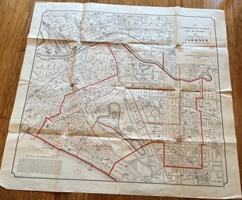 Melbourne Tram Museum
Map, Department of Lands and Survey Melbourne, Commonwealth Electoral Division of Fawkner, 1-10-1912
... Department of Lands and Survey Melbourne... Department of Lands and Survey Melbourne ...Shows a detailed street plan of South Melbourne, Albert Park, Prahran, South Yarra and parts of Melbourne in 1912. Used to mark the electoral boundaries of the Commonwealth Electoral Division of Fawkner. Shows all the then cable tram lines, rail lines and the electric line of the PMTT along with docks, gardens and significant buildings.Gives details of the Fawkner Electoral district in 1912.Folded sheet - Map - Commonwealth Electoral Division of Fawkner - two colours showing the subdivisions and polling placesmelbourne, fawkner, tram lines, cable trams, maps, electoral maps, south melbourne, albert park, prahran -
Stawell Historical Society Inc
Map, Department of Lands and Survey Melbourne, Swinton Estate. Parish of Riachella. County of Borong, 3-08-1921
... Department of Lands and Survey Melbourne... Department of Lands and Survey Melbourne ...Shows part of Warranook TrainwayA1 Printed Map With Cloth Backing. Annotations in Red Ink W.J. Butson 3-8-21farming -
Clunes Museum
Plan - TITLE PLAN, DEPARTMENT OF LANDS AND SURVEY, PARISH OF CLUNES - COUNTY OF TALBOT, 1959
... DEPARTMENT OF LANDS AND SURVEY... OF CLUNES - COUNTY OF TALBOT Plan TITLE PLAN DEPARTMENT OF LANDS ....1 1 PAGE PLAN LISTING TITLES FOR THE PARISH OF CLUNES 1959 (3 COPIES) SHEET 1 SCALE: 1 INCH TO 40 CHAINS .2 1 PAGE PLAN LISTING TITLES FOR THE PARISH OF CLUNES 1959 SHEET 2 SCALE: 1 INCH TO 2 CHAINSBY AUTHORITY A C BROOKS GOVT. PRINTER, MELBOURNE PARISH OF CLUNESparish of clunes, title plans clunes -
Clunes Museum
Map, DEPARTMENT OF LANDS AND SURVEY, TOWNSHIP OF CLUNES, PARISH OF CLUNES, COUNTY OF TALBOT, 1950
... DEPARTMENT OF LANDS AND SURVEY... OF CLUNES, PARISH OF CLUNES, COUNTY OF TALBOT Map MAP DEPARTMENT ...MAP OF CLUNES ON PAPER SHOWING HOTELS AND TOWNSHIP HIGHLIGHTS COMPLETE WITH LEGEND. OVERWRITTEN NOTATIONS IN RED AND BLUE INKPRICE 2stownship of clunes 1950, hotels of clunes -
Clunes Museum
Map, A.C. BROOKS GOVERNMENT PRINTER MELBOURNE, EGLINTON COUNTY OF TALBOT, 1965
... DEPARTMENT OF LANDS AND SURVEY... A.C. BROOKS GOVERNMENT PRINTER MELBOURNE. DEPARTMENT OF LANDS ...MAP OF EGLINTONMAP OF EGLINTON, COUNTY OF TALBOT PRINTED ON CANVAS WITH PLASTIC TAB FOR HANGING. MAP SHOWS TOWN ALLOTMENTSADMINISTRATIVE STAMP ON BOTTOM LEFT AND ON THE BACK OF THE MAP ANOTHER STAMP - NORTHERN DIVISION (299) FORESTS COMMISSION BENDIGOeglinton, historical map -
Clunes Museum
Map, DEPARTMENT OF LANDS AND SURVEY
... DEPARTMENT OF LANDS AND SURVEY... OF ALLOTMENTS IN CLUNES Map MAP DEPARTMENT OF LANDS AND SURVEY ...MAP OF ALLOTMENTS IN CLUNESlocal history, documents, map, township, clunes -
Clunes Museum
Plan - TITLE PLAN, DEPARTMENT OF LANDS AND SURVEY, TOWNSHIP OF GLENGOWER
... DEPARTMENT OF LANDS AND SURVEY... PLAN DEPARTMENT OF LANDS AND SURVEY W M HOUSTON ...1 PAGE PLAN OF THE TOWNSHIP OF GLENGOWER COUNTY OF TALBOT (11 COPIES) DRAWN AND REPRODUCED AT THE DEPT. OF LANDS AND SURVERY MELBOURNE VICTORIA NOVEMBER 1954 PRICE 2/-parish of glengower, title plan of glengower -
Clunes Museum
Book, DEPARTMENT OF LANDS AND SURVEY, LICENCE
... DEPARTMENT OF LANDS AND SURVEY... DEPARTMENT OF LANDS AND SURVEY ...RECEIPTS ISSUED TO CUSTOMER DENOTING LOCALITY TO SPLIT AND TAKE AWAY EUCALYPTUS TIMBER FROM BUSH. LICENCES ISSUED PER QUARTER.BLUE CARDBOARD COVERED BOOK CONTAINING TIMBER LICENSE FOR ORDINARY WOOD ISSUED SEPTEMBER 1884 TO OCTOBER 1892. RECEIPT NUMBERS 124121 - 124130ON FRONT COVER: TIMBER LICENSE ORDINARY WOOD 50/- NO.1 EXHAUSED AFTER AUDIT 23-8-92local history, book, licence, receipt, timber licence -
University of Melbourne, Burnley Campus Archives
Document - Circular, Department of Crown Lands and Survey. Complete list of weeds declared noxious in the State of Victoria, 1964-1972
... Department of Crown Lands and Survey. Complete list of... and Noxious Weeds Act 1928) Department of Crown Lands and Survey ...Chart prepared by Vermin and Noxious Weeds branch. Plants proclaimed under the Noxious Weeds Act 1928 (No 3799) for the State of Victoria.. Plants proclaimed within certain Municipalities of Victoria. Includes tables of Chemical Treatment and other remarks.Large circular - Complete list of weeds proclaimed noxious within the State of Victoria and for certain Municipalities and table of quantities for chemical treatment together with brief instructions for treatment of Noxious Weeds (Vermin and Noxious Weeds Act 1928)weeds, vermin and noxious weeds act 1928, chemical treatment of weeds -
 Bacchus Marsh & District Historical Society
Map, Village allotments, Parish of Myrniong, County of Bourke
... at the Department of Lands & Survey, Melbourne, in 1903. Based... at the Department of Lands & Survey, Melbourne by T.F. McGauran, 24.12.03... ; photo-lithographed at the Department of Lands & Survey ...Myrniong is a village 9 kilometers west of Bacchus Marsh. Prior to 1863 the area was known as Blow's Flat. This map which was produced in 1903 and according to the catalogue record of this map held at the State Library of Victoria was based on an earlier map created in 1861. The early layout of streets for the village of Myrniong can be seen on this map. The streets shown are, Main Street, Hardy Street, Blow Street, Myrniong Street, Shuter Street, and Blackwood Street. An area marked as a reserve for a school can be seen between Hardy Street and Main Street.A single page paper map. A cadastral parish map of Myrniong in Victoria, showing numbered land allotments. Photo-lithographed at the Department of Lands & Survey, Melbourne, in 1903. Based on an original map created in 1861. The map is pasted into a bound volume containing 76 maps or plans in total. High resolution digital image stored on BMDHS computer network. Surveyed by John Hardy, Surveyor ; photo-lithographed at the Department of Lands & Survey, Melbourne by T.F. McGauran, 24.12.03myrniong parish plan, myrniong parish maps -
Whitehorse Historical Society Inc.
Map, M.M.B.W, c1962
... Victoria. Department of Lands and Survey...Prepared by Department of Lands and Survey and Melbourne... by Department of Lands and Survey and Melbourne and Metropolitan Board... Mitcham melbourne Prepared by Department of Lands and Survey ...Melbourne Metropolitan Area Base Map series sheet 235, covering part, Mitcham, Nunawading and Ringwood areas.Melbourne Metropolitan Area Base Map series sheet 235, covering part, Mitcham, Nunawading and Ringwood areas. Prepared by Department of Lands and Survey and Melbourne and Metropolitan Board of Works from State aerial Survey, June 1957 and Cadastral Survey information, August 1960. Scale 1:4,800.Melbourne Metropolitan Area Base Map series sheet 235, covering part, Mitcham, Nunawading and Ringwood areas. maps, mitcham, nunawading, ringwood, melbourne and metropolitan board of works, victoria. department of lands and survey -
 Federation University Historical Collection
Plan, Department of Crown Lands and Survey, Melbourne, Buninyong County of Grant, 23/07/1929
... Department of Crown Lands and Survey, Melbourne... County of Grant Plan Department of Crown Lands and Survey ...The plan was photo-lithographed at the Departmen tof Lands and Survey, MelbourneA parish plan of Buninyong, including Robert Scott's Mt Buninyong Pre-emptive Right, Mt Buninyong Public Park, Thomas Learmonth's land, John Learmonth's land, Scotchan's, Yendon. The Buninyong POst Office is Allotment 1. Pisition of tracks in 1859 have been marked on the plan in red.buninyong, scotchman's, mt buninyong, robert scott, clarendon, lal lal creek, yendon, warrenheip, yarowee, enfield, thomas learmonth, john learmonth, archibald fisken, g. schloo, george innes, peter inglis, durham lead, j. fry, j. forrest, parkin lee, buninyong recreation reserve -
 Greensborough Historical Society
Map, Victoria. Department of Crown Lands and Survey, Keelbundoora; Counties of Bourke and Evelyn, 1950c
... Victoria. Department of Crown Lands and Survey...; Counties of Bourke and Evelyn Map Victoria. Department of Crown ...Map of the Victorian counties of Bourke and Evelyn showing parish boundaries and land ownership.Show the original landholders for this area.Map on light brown parchment, covered in plastic."L.5305" and "3462" -
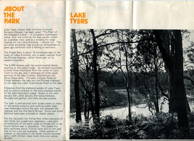 Orbost & District Historical Society
pamphlet, Lake Tyers Forest Park, 1960's
... Department of Crown Lands & Survey... Department of Crown Lands & Survey ...This pamphlet would have been produced as a tourist guide to East Gippsland.This item is a useful reference tool.A three fold glossy, pamphlet titled"Lake Tyers Forest Park". It contains information, a map and black / white photographs of Lake Tyers Park. Print colours are brown, white, yellow and black.pamphlet lake tyers-forest-park -
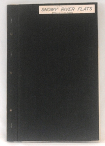 Orbost & District Historical Society
plans, 1966?
... plans-survey Snowy-River-Flats Department-Crown-Lands...Department of Crown Lands & Survey...-survey Snowy-River-Flats Department-Crown-Lands-Victoria A flat ...These survey plans are a useful research tool.A flat green fabric folder with a white label with "SNOWY RIVER FLATS" hand-written in black. It contains plans.plans-survey snowy-river-flats department-crown-lands-victoria -
 Federation University Historical Collection
Plan, Haddon, County of Grenville, 1932, 13/04/1932
... Department of Crown Lands and Survey, Melbourne... Haddon, County of Grenville, 1932 Plan Plan Department of Crown ...The Haddon Parish Plan shows crown parcels government roads, Crown Reserves, Railway. Scale 40 chains to 1" (1:31, 680) WGS 84 Centroid Lat: 37 degrees 34' 00" S Long: 148 degrees 40' 20" E N.S. 9.3km E.W.: 16.1kmhaddon, grenville, cardigan, water supply reserve, nentingbook pre-emptive right, a. mclachlan, lake burrumbeet, e.a. wynne, p. russell, b. hepburn, benjamin hepburn, nentingbool, t.c. wilson, j. amoy, william collard smith, james roach, j. mitchell -
 Federation University Historical Collection
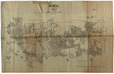
Plan, Dereel Parish Plan, 1928, 16/07/1928
... Department of Crown Lands and Survey... W.J.Butson Department of Crown Lands and Survey ...Parish Plan of Dereel showing crown allotments, dimensions, crown grantees, dates of grant. Scale 1:31,680 WGS 84 Centroid 37 degrees 48 feet 33 inches S 143 degrees 41 feet 46 inches S NS: 6.3km EW: 15.2kmdereel, parish plan, p. mclachlan, rifle range, j. bower, dereel lagoon, t. mellington, j. mcdonald -
 Federation University Historical Collection
Plan, Parish of Dowling Forest, County of Ripon and Grenville, 19
... Department of Crown Lands and Survey... Forest, County of Ripon and Grenville Plan Department of Crown ...Scale [1:31 680]. 40 chains to 1 in.Geological map on a cadastral base, showing the occurence of reefs, and alluvial deposits. Relief shown by contours.dowling forest, wyndholm, wyndholm pre-emptive right, miners rest, ballarat racecourse, winter's swamp, police reserve, miner's rest, winters swamp, geology -
 Victorian Aboriginal Corporation for Languages
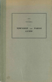
Book, Department of Crown Lands and Survey Victoria, Township and parish guide : Victoria, 1955
... Department of Crown Lands and Survey Victoria... of Proclamation. Township and parish guide : Victoria Book Department ...A alphabetical list of townships proclaimed under the Land Acts of Victoria. Shows the parish, land district and the municipality in which each is situated, and the particulars of Gazettal of Proclamation.victorian geographical names, victorian administration -
 Peterborough History Group
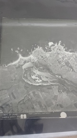
Photograph - Aerial Photograph Peterborough, Department of Crown Lands & Survey, Jan 1971
... Department of Crown Lands...Department of Crown Lands & Survey... Department of Crown Lands Stamped Dept of Crown Lands & Survey Square ...Aerial photograph showing the past layout of the townSignificant in that it shows the town as it was in 1971.Square 9" x 9" aerial photograph x 4 - (2 photos in duplicate)Stamped Dept of Crown Lands & Surveypeterborough 3270, curdies estuary, bay of islands, crown land photograph, aerial photograph, department of crown lands -
 Bayside Gallery - Bayside City Council Art & Heritage Collection
Map, Department of Crown Lands and Survey, Moorabbin, County of Bourke, c. 1918
... Department of Lands and Survey...Department of Crown Lands and Survey... Department of Lands and Survey Land owners cartographic material ...The cadastral map of the Parish of Moorabbin in Victoria (L.6104) shows parish boundaries and land ownership c. 1918 when Sandringham was a Borough.moorabbin, county of bourke, map, plan, land subdivision, land titles, foreshores, sndringham, hampton, beaumaris, highett, cheltenham, department of lands and survey, land owners, cartographic material, borough of sandringham, brighton -
 Federation University Historical Collection
Map - Geological Survey, J. Phillips, Geological Survey of Victoria - Ballarat, 1857, 10/1858
... Department of Crown Lands and Survey, Melbourne..., 1857 Map Geological Survey J. Phillips Department of Crown ...Geological map of the Ballarat District featuring four colours.ballarat, geological, geology, geological plan, main road, camp, golden point, pennyweight hill, clayton hill, ballaarat cemetery, bakery hill, specimen hill, soldiers hill, nightingale lead, native youth black hill flat, white flat, mining, mines, eureka lead, old post office hill -
 The Beechworth Burke Museum
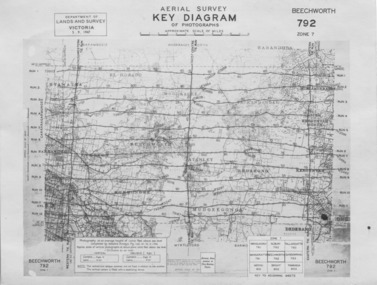
Photograph - Aerial Survey, 5/9/1947
... department of lands and survey... and surrounding area. Issued by Department of Lands and Survey, Victoria..., APPROXIMATE SCALE OF MILES / DEPARTMENT OF LANDS AND SURVEY VICTORIA... and surrounding area. Issued by Department of Lands and Survey, Victoria ...This image is an Aerial Survey, Key Diagram of Beechworth and surrounding area. Issued by Department of Lands and Survey, Victoria in 1947. Photographed at an average height of 12300 feet above sea level, areas depicted are; Beechworth, Stanley, Bruarong, Baranduda, Muagegonga, Myrtleford, Everton, Wooragee North Tarrawinge, Dederang, Kergunyah North, Kergunyah, Yackandandah, El-Dorado, Barambogie, Murmungee, Barwidgee, Oxley, CarraragarmungeeBlack and white rectangular photograph. Image is printed on matt photographic paper and has a white un-printed border. Obverse: AERIAL SURVEY, KEY DIAGRAM OF PHOTOGRAPHS, APPROXIMATE SCALE OF MILES / DEPARTMENT OF LANDS AND SURVEY VICTORIA 5.9.1947. BEECHWORTH 792 ZONE 7. Reverse: BMM7010.1 (written in pencil) aerial survey, beechworth, burke museum, department of lands and survey, victoria, 1947