Showing 192 items matching "district surveyor"
-
 Warrnambool and District Historical Society Inc.
Documents, 1930s,40s,50s,60s
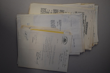
These documents came from the office of Rolf Crawley who was an engineer, surveyor and architect in private practice in Warrnambool and also the engineer for the Shire of Warrnambool from 1935 to 1968. His grandfather, father and uncle were also engineers, working in that capacity for the Shire of Warrnambool or as Secretary for the Shire of Warrnambool, with the Crawley family recording a total of 132 years of service to the Shire. The Shire of Warrnambool existed from 1863 to 1994. The documents came into the possession of Michael Hand who took over the Crawley surveying business in Warrnambool. The Warrnambool and District Historical Society acquired the documents, along with other Crawley memorabilia, from the Michael Hand Estate. These documents will be useful for reference and research, particularly in regard to the Shire of Warrnambool history.This is a packet of documents from the office of Rolf Crawley. They are mostly single sheets which include letters from the Office of the Surveyors Board, documents relating to employees and trainees and some Government papers. They are mostly typewritten with the signature of Rolf Crawley. There is one map of the Eumerella Drainage area.rolf crawley, warrnambool, shire of warrnambool -
 Warrnambool and District Historical Society Inc.
Documents, Rolf Crawley, Warrnambool, Warrnambool Race Course, 1920s and 30s
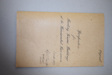
These documents deal with improvements in the 1920s and 30s (drainage, painting etc) to the Warrnambool Race Course. In 1854 the Warrnambool Racing Club was established and the first race meeting on the present day Warrnambool Race Course was held in 1858. These documents came from the office of Rolf Crawley, an engineer, architect and surveyor in private practice in Warrnambool and the engineer for the Shire of Warrnambool from 1935 to 1968. His grandfather, father and uncle were also engineers and worked in that capacity or as the Shire Secretary for the Shire of Warrnambool, with the Crawley family recording a total of 132 years of service to the Shire. The Shire of Warrnambool existed from 1863 to 1994. The documents came into the possession of Michael Hand who had taken over the private surveying business of Rolf Crawley in Warrnambool. The Warrnambool and District Historical Society acquired these documents and other Crawley material, from the Michael Hand estate. These documents are of considerable interest as they concern the Warrnambool Race Course improvements in the 1920s and 30s and come from the office of Rolf Crawley of Warrnambool. These are seven documents relating to the Warrnambool Race Course: .1 A manila folder with a handwritten title on the front cover and typed and printed material inside .2 A sketch map of the Warrnambool Race Course produced on heavy quality white paper. .3 Hand-drawn material on the underground drains on the Warrnambool Race Course produced on heavy quality white paper .4 & .5 Longitudinal section of the main drain, Warrnambool Race Course, produced on heavy quality white paper .6 Section of the drain near the fence and culvert of the Warrnambool Race Course produced on heavy quality paper .7 A piece of paper giving the chainage of the Warrnambool Race Course in red handwriting. warrnambool race course, rolf crawley, warrnambool -
 Warrnambool and District Historical Society Inc.
Book, Cummings Architectural Details, 1873
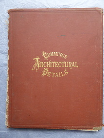
... and surveyor. He was appointed District Engineer for the Public Works...Warrnambool and District Historical Society Inc. 2 Gilles ...This book was owned by John Crawley, engineer, architect and surveyor. He was appointed District Engineer for the Public Works Department for the Western District in 1866. He was the Shire of Warrnambool Engineer from 1874 to 1895 when he was succeeded by his son.This book is of interest as it contains examples of architectural designs from U.S.A. in the 1870s. Designs such as these influenced the designs of buildings in other countries including Australia. This book is also of interest because of its connection to John Crawley, a member of the Crawley family that had a long and influential association with the Shire of Warrnambool.This is a hard cover book. It has a brown cover with gold lettering. The book has come apart from its binding so many of the pages are loose and the covering on the spine is missing . The front cover is somewhat stained and the edges are worn. The book has many diagrams and illustrations.The inscriptions are handwritten in black ink J. W. Crawley Warrnambool J.W. Crawley 1879john crawley -
 Warrnambool and District Historical Society Inc.
Book, Architecture, 1870s
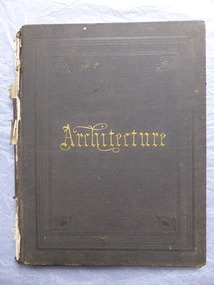
... , architect and surveyor who was appointed District Engineer... and surveyor who was appointed District Engineer for the Public Works ...This book belonged to John William Crawley an engineer, architect and surveyor who was appointed District Engineer for the Public Works Department in the Western District in 1866. He was the Shire of Warrnambool Engineer from 1874 to 1895 when he was succeeded by his son. This book is of minor importance as a memento of John William Crawley an important engineer in the Shire of WarrnamboolThis is a hard cover book with pages containing architectural plans,designs and printing. Some of the pages are blank.The cover is faded and spotted and has a gold title The spine is damaged .Inside the front cover is an inscription and on the following page is another inscription.J.W Crawley 1879 Architecture john william crawley, shire of warrnambool -
 Warrnambool and District Historical Society Inc.
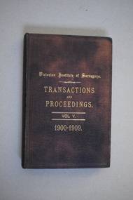
Book, Victorian Institute of Surveyors Transactions and Proceedings Vol V, 1910
This book belonged to John William Crawley, Junior who had acquired it in 1910 as a member of the Victorian Institute of Surveyors. John Crawley was an engineer, architect and surveyor in private practice in Warrnambool and also the official engineer of the Shire of Warrnambool from 1896 to 1935. His father, brother and son were also engineers and worked in that capacity for the Shire of Warrnambool or as the Shire Secretary, with the Crawley family members recording a total of 132 years of service to the Shire of Warrnambool which existed from 1863 to 1994. This book is retained as it belonged to John Crawley, the engineer for the Shire of Warrnambool for forty years. This is a hard cover book with a dark brown cover with gold printing on the front cover and spine. The cover is now stained. The book contains an introduction, twenty papers and reports from 1905 to 1910. There are many black and white photographs and fold-out maps and plans. The signature on the second page is handwritten in black ink. J.W.Crawley W’bool 26.3.10crawley family, warrnambool, shire of warrnambool, history of warrnambool -
 Warrnambool and District Historical Society Inc.
Publication, Wild & Beissel Pty Ltd, Booklet, 1939
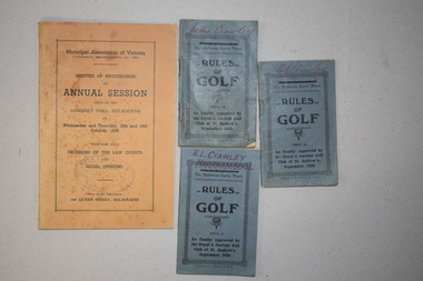
One of these booklets contains the Minutes of Procedure of the Annual Session of the Municipal Association of Victoria in October 1939. The other three items are booklets containing the rules of golf as approved by the Golf Club of St Andrews in 1920. The four items belonged to Rolf Crawley who had a private surveying, engineering and architects practice in Warrnambool and was also the engineer for the Shire of Warrnambool from 1935 to 1968. The Shire of Warrnambool existed from 1863 to 1994. Rolf Crawley’s grandfather, father and uncle were also engineers and worked in that capacity or as the Shire Secretary for the Shire of Warrnambool, with the Crawley family recording a total of 132 years of service to the Shire. The items came into the possession of Michael Hand who took over the private surveying business of Rolf Crawley in Warrnambool. The Warrnambool and District Historical Society acquired the items, along with several ledgers and other Crawley memorabilia, from the estate of Michael Hand. These booklets are of minor interest as items that belonged to Rolf Crawley, the engineer for the Shire of Warrnambool in the mid 20th century..1 This is a buff-coloured booklet of 121 pages. It has printed matter and one black and white photograph. It has two mauve stamps on the front cover and on the first page. .2.3.4 These are three small identical booklets with blue covers. They each contain 48 pages and have black and white advertisements. They have handwritten names on the front covers. .1 ‘Rolf L. Crawley Civil Engineer, Drainage and Water Supply Engineer, Licensed Surveyor, Registered Architect, Warrnambool’ .2.3.4. ‘Rolf L. Crawley Warrnambool’ ‘Nettie Crawley’ rolf crawley, warrnambool, shire of warrnambool -
 Warrnambool and District Historical Society Inc.
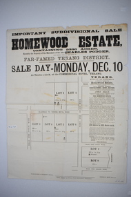
Original document, Advertising "Homewood Estate" Terang, 1886
This notice advertises the sale of the Homewood property near Glenormiston. The sale details state that the property is 2386 acres adjoining "The Sisters" the station of the Black Brothers. The property lies on the main metal road from Terang to Ellerslie, six miles from Terang. It has frontage to Pejark Marsh/drain. It was to be surveyed and sold in blocks of 250 to 300 acres with permanent water and well covered with grasses. The sale of the property followed the death of Charles Podger who died in 1886. On his death he left his wife Ann and six children.His worth was over 20000 pounds with 16000 pounds as real estate and 4300 pounds in personal propertyThe Agent for the sale was James Jellie, solicitors were Warrnambool firm Klingender and O'Mahony and the advertisement was printed by Thomas Smith Gas printing Works Warrnambool. This document has local interest and significance as an early sales of land in the district. The names of agents , solicitors and printers were wll known in the area and the property also a large holding. The Podger name is also well represented in the district to this day.Large white rectangular sheet of paper with black text . Major sale details in heavy black text at the top with descriptive text accompanying map of subdivision of the property on the left.The following names and details are contained within the document. Homewood Estate, Charles Podger, Commercial Hotel Terang, James Jellie Fenelon Mott Surveyor, Klingender & O'Mahony solicitors, Thos, Smith Gas Printing Koroit Street Warrnamboolcharles podger, homewood estate, klingender, o"mahony, kolora, the sisters, terang -
 Warrnambool and District Historical Society Inc.
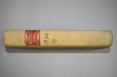
Letter book, J & R Crawley, 1934
This letter book contains letters, sketch maps and plans and dates from1934 to 1936. It originally came from the office of John William Crawley Junior, an engineer, surveyor and architect in private practice in Warrnambool and also the Shire Engineer for the Shire of Warrnambool from 1895 to 1935. His father, brother and son were also engineers and worked in that capacity or as the Shire Secretary for the Shire of Warrnambool, with the Crawley family recording a total of 132 years of service to the Shire. The Shire of Warrnambool existed from 1863 to 1994. The letter book was also used in the private practice of John Crawley’s son, Rolf who was the engineer for the Shire of Warrnambool from 1935 to 1968. The letter book then came into the possession of Michael Hand who took over the private surveying business of Rolf Crawley in Warrnambool. The Warrnambool and District Historical Society acquired the letter book, along with several other Crawley ledgers, from the estate of Michael Hand.This letter book is of considerable significance as it contains letters written by John Crawley and Rolf Crawley who were in an engineering, surveying and architects private practice in Warrnambool over the time covered in the book. It will be very useful to researchers. This is a hard cover book of 1000 pages but only 354 pages have been used. The cover is bound at the corners and on the spine with buff-coloured leather. The book contains an alphabetical index, handwritten letters, sketch maps and plans. ‘Private Letter Book 1934- 19.’ ‘R.L./J. W. Crawley Private’ john william crawley junior, warrnambool, rolf crawley, warrnambool, shire of warrnambool -
 Warrnambool and District Historical Society Inc.
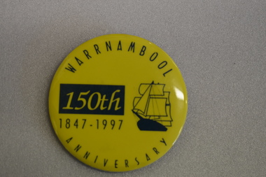
Badge, Warrnambool 150th 1847-1997
This badge was produced in 1997 as a souvenir of the 150th anniversary of the founding of Warrnambool. Warrnambool was a planned town, established in 1847 as a port to service the squatters who had taken up large tracts of land in the Warrnambool area in the 1840s.The town was surveyed by the Government surveyor William Pickering at the request of Superintendent La Trobe and the first town lots of the new town were sold in Melbourne in 1847, with some settlers arriving at the new settlement soon after.This badge is one of the many souvenirs of the 1997 celebrations in Warrnambool Circular concave metal badge with blue drawing of a sailing ship and text. There is a clip pin on the reverse.WARRNAMBOOL ANNIVERSARY 150th 1847 -1997 -
 Eltham District Historical Society Inc
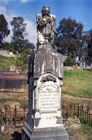
Negative - Photograph, Harry Gilham, Grave of Alfred and Margaret Armstrong, Eltham Cemetery, Victoria, Sep 2009
Alfred Patrick Armstrong was born in England in 1825 and was employed under the renowned Isambard Kingdom Brunel as a civil engineer during the construction of the Great Western Railway and the South Wales Railway. He came to Melbourne in 1852 and purchased property in Eltham. He became a mining surveyor and was Inspector of Mines and the Mining Registrar for the St Andrews Division of the Castlemaine Mining District. In 1855, he chaired a meeting calling for a bridge to be erected across the Yarra River between Eltham and Temple Stow. He was registered as an innkeeper in 1858, was a recognised collector of the £110 raised for the building of the first building of State School No. 209 (Eltham Primary) and was a Trustee for the Church of England site on the Eltham Cemetery Trust in 1860. He was elected to the Eltham District Road Board (forerunner of Eltham Shire Council) from 1867 to 1871 and then served as an Eltham Shire Councillor from 1871 to 1878 (including Shire President in 1873). Margaret Armstrong to whom he was married in 1854 at St Pauls Church, Melbourne, died on the 27th March 1887. Alfred died in 1893, having been in ill health for some time, and is buried in Eltham Cemetery with his wife Margaret. The monument features a tall pillar capped with a draped urn: a symbol of death. In Loving Memory of Alfred Armstrong Died May 27tth 1893 Aged 68 years Also of his wife Margaret Died March 27th 1887 Aged 63 years This burial site is of special interest as the monument has the tallest pillar-a vase-a draped cloth top (unfulfilled life) and additional panels of names around the sides and the base, which include: Ada Gertrude Armstrong, beloved daughter of Alfred & Margaret Armstrong, died May 30th 1878, aged 21 years Mary Armstrong, beloved mother to Alfred Armstrong, died April 10th, 1886 aged 82 years Arthur Vivian Harrison, died 4th Nov. 1899, aged 8 years Arthur Reynolds Stockwood Armstrong, son of Alfred Armstrong, died 4th Nov. 1908, aged 43 years Laura Augusta Harrison nee Armstrong, died 26th July 1921, aged 64 yearsRoll of 35mm colour negative film, 6 stripsKodak GC 400-9eltham cemetery, gravestones, alfred armstrong, margaret armstrong, ada gertrude armstrong, arthur reynolds stockwood armstrong, arthur vivian harrison, laura augusta harrison (nee armstrong), mary armstrong -
 Eltham District Historical Society Inc
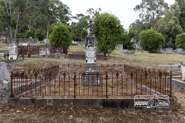
Photograph, Peter Pidgeon, Grave of Alfred and Margaret Armstrong, Eltham Cemetery, Victoria, 5 April 2021
Alfred Patrick Armstrong was born in England in 1825 and was employed under the renowned Isambard Kingdom Brunel as a civil engineer during the construction of the Great Western Railway and the South Wales Railway. He came to Melbourne in 1852 and purchased property in Eltham. He became a mining surveyor and was Inspector of Mines and the Mining Registrar for the St Andrews Division of the Castlemaine Mining District. In 1855, he chaired a meeting calling for a bridge to be erected across the Yarra River between Eltham and Temple Stow. He was registered as an innkeeper in 1858, was a recognised collector of the £110 raised for the building of the first building of State School No. 209 (Eltham Primary) and was a Trustee for the Church of England site on the Eltham Cemetery Trust in 1860. He was elected to the Eltham District Road Board (forerunner of Eltham Shire Council) from 1867 to 1871 and then served as an Eltham Shire Councillor from 1871 to 1878 (including Shire President in 1873). Margaret Armstrong to whom he was married in 1854 at St Pauls Church, Melbourne, died on the 27th March 1887. Alfred died in 1893, having been in ill health for some time, and is buried in Eltham Cemetery with his wife Margaret. The monument features a tall pillar capped with a draped urn: a symbol of death. In Loving Memory of Alfred Armstrong Died May 27tth 1893 Aged 68 years Also of his wife Margaret Died March 27th 1887 Aged 63 years This burial site is of special interest as the monument has the tallest pillar-a vase-a draped cloth top (unfulfilled life) and additional panels of names around the sides and the base, which include: Ada Gertrude Armstrong, beloved daughter of Alfred & Margaret Armstrong, died May 30th 1878, aged 21 years Mary Armstrong, beloved mother to Alfred Armstrong, died April 10th, 1886 aged 82 years Arthur Vivian Harrison, died 4th Nov. 1899, aged 8 years Arthur Reynolds Stockwood Armstrong, son of Alfred Armstrong, died 4th Nov. 1908, aged 43 years Laura Augusta Harrison nee Armstrong, died 26th July 1921, aged 64 yearsBorn Digitaleltham cemetery, gravestones, ada gertrude armstrong, alfred armstrong, arthur reynolds stockwood armstrong, arthur vivian harrison, laura augusta harrison (nee armstrong), margaret armstrong, mary armstrong -
 Eltham District Historical Society Inc
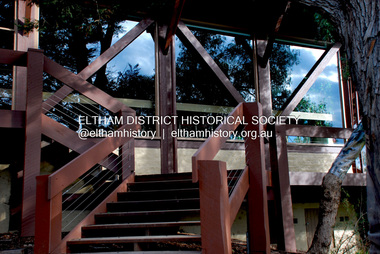
Photograph - Digital Photograph, Jim Connor, Eltham Community and Reception Centre, 801 Main Road, Eltham, 9 July 2008
The Eltham Community and Reception Centre was Australia's first public mud-brick building. Commissioned in 1977 by Eltham Shire Council, led by Shire president (and architect) Robert Marshall, architects Whitford and Peck were asked to design a multipurpose facility in mud-brick and timber. The official opening was performed by the Hon. R.J. Hamer; E.D., M.P., Premier of Victorai on Saturday, April 22, 1978. Architects: Whitford & Peck Pty Ltd Quantity Surveyor: D.J. Cant & Associates Structural Civil Engineers: Charlett & Moore Pty Ltd Landscape: Peter Glass, Dennis Edwards Mech Elec: Lobley Treidel & Partners Pty Ltd Acoustics: Riley Barden & Kirkhope Builder: L.U. Simon Pty Ltdjim connor collection, eltham community and reception centre, eltham community centre, mudbrick construction -
 Eltham District Historical Society Inc
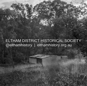
Negative - Photograph, J.A. McDonald, Road Reserve Housing, Mar. 1961
Shack built on road reserve without permit Most probably up on Simms Road, Kinglake Other areas where illegal shacks were built wer at the junction of Flat Rock Road and Cherry Tree Road, Hurstbridge. At times, Building Surveyor George E Newton would have to attend to these shacks for inspection and issue demolition ordersRecord of various Shire of Eltham infrastructure works undertaken during the period of 1952-1962 involving bridge and road reconstruction projects, sometimes with Eltham Shire Council Project Reference numbers quoted. It was during this period that a number of significant improvements were made to roads and new bridges constructed within the shire that remain in place as of present day (2022). In many situations, the photos provide a tangible visible record of infrastructure that existed throughout the early days of the Shire. The album was put together by or under the direction of the Shire Engineer, J.A. McDonald.infrastructure, shire of eltham, 1961-03, building surveyor, cherry tree road, flat rock road, george e. newton, houses, hurstbridge, kinglake, road reserve, road reserve housing, scan - 120 format 6x6 negative, shack, simms road -
 Eltham District Historical Society Inc
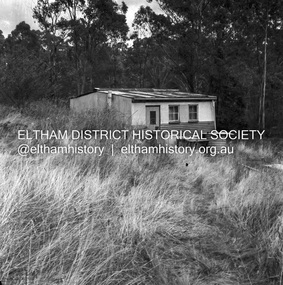
Negative - Photograph, J.A. McDonald, Road Reserve Housing, Mar. 1961
Shack built on road reserve without permit Most probably up on Simms Road, Kinglake Other areas where illegal shacks were built wer at the junction of Flat Rock Road and Cherry Tree Road, Hurstbridge. At times, Building Surveyor George E Newton would have to attend to these shacks for inspection and issue demolition ordersRecord of various Shire of Eltham infrastructure works undertaken during the period of 1952-1962 involving bridge and road reconstruction projects, sometimes with Eltham Shire Council Project Reference numbers quoted. It was during this period that a number of significant improvements were made to roads and new bridges constructed within the shire that remain in place as of present day (2022). In many situations, the photos provide a tangible visible record of infrastructure that existed throughout the early days of the Shire. The album was put together by or under the direction of the Shire Engineer, J.A. McDonald.infrastructure, shire of eltham, 1961-03, building surveyor, cherry tree road, flat rock road, george e. newton, houses, hurstbridge, kinglake, road reserve, road reserve housing, scan - 120 format 6x6 negative, shack, simms road -
 Eltham District Historical Society Inc
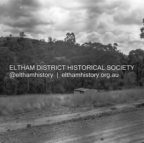
Negative - Photograph, J.A. McDonald, Road Reserve Housing, Mar. 1961
Shack built on road reserve without permit Most probably up on Simms Road, Kinglake Other areas where illegal shacks were built were at the junction of Flat Rock Road and Cherry Tree Road, Hurstbridge. At times, Building Surveyor George E Newton would have to attend to these shacks for inspection and issue demolition ordersRecord of various Shire of Eltham infrastructure works undertaken during the period of 1952-1962 involving bridge and road reconstruction projects, sometimes with Eltham Shire Council Project Reference numbers quoted. It was during this period that a number of significant improvements were made to roads and new bridges constructed within the shire that remain in place as of present day (2022). In many situations, the photos provide a tangible visible record of infrastructure that existed throughout the early days of the Shire. The album was put together by or under the direction of the Shire Engineer, J.A. McDonald.infrastructure, shire of eltham, 1961-03, building surveyor, cherry tree road, flat rock road, george e. newton, houses, hurstbridge, kinglake, road reserve, road reserve housing, scan - 120 format 6x6 negative, shack, simms road -
 Eltham District Historical Society Inc
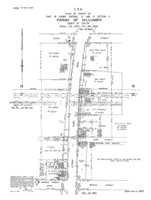
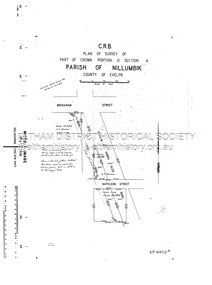
Document - Survey Plan, Country Roads Board, SP 6800, Eltham-Yarra Glen Road; Bridge St to Henry St, 1958
1958 C.R.B. Plan of Survey of Part of Crown Portions 12 and 13 Section 4 Parish of Nillumbik, County of Evelyn Eltham-Yarra Glen Road., Shire of Eltham Shows Surveyor field notes, property ownership and building type and construction.1958, a.m. gahan, a.s & s.j. davis, annie ellen davies, bridge street, country roads board, d.a. lyon, dave lyon, eltham, flora towell, g.e. gallagher, henry street, j. lyon, k. greene, main road, p.a. gahan, survey plan, w.l. chynoweth pty ltd, york street, neil webster collection -
 Eltham District Historical Society Inc
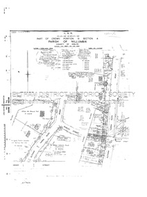
Document - Survey Plan, Country Roads Board, SP 6801, Eltham-Yarra Glen Road; Brougham St to Bridge St, 1958
1958 C.R.B. Plan of Survey of Part of Crown Portion 12 Section 4 Parish of Nillumbik, County of Evelyn Eltham-Yarra Glen Road, Shire of Eltham Shows Surveyor field notes, property ownership and building type and construction.a.j. collis, a.s. & c.g.h. fitzpatrick, board of land & works, bridge street, brougham steet, commonwealth bank of australia, country roads board, eltham, eltham rsl sub-branch, f.h. collis, f.m. smith, f.n. & e.j. burgoyne, franklin street, h.c. & r.e. burgoyne, j. jorgenson, j.f. & j.e. morris, j.n. & h.c. burgoyne, j.s. blow, john street, main road, p.e. smith, pitt street, r.j. dripps, s.j. taylor, survey plan, trustees of the eltham methodist church, 1958, eltham-yarra glen road, neil webster collection -
 Eltham District Historical Society Inc
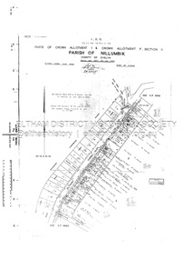
Document - Survey Plan, Country Roads Board, SP 6802, Eltham-Yarra Glen Road; Brougham St to Dalton St, 1958
1958 C.R.B. Plan of Survey of Part of Crown Portion 12 Section 4 Parish of Nillumbik, County of Evelyn Eltham-Yarra Glen Road, Shire of Eltham Shows Surveyor field notes, property ownership and building type and construction.1958, eltham-yarra glen road, a.f. munday, bible street, brougham steet, country roads board, dalton street, eltham, j.p. & e.a. sanders, j.w. & e. m. graham, l.c. skipper, l.m. jarrold, main road, napoleon street, survey plan, neil webster collection, franco and co -
 Eltham District Historical Society Inc
Document - Survey Plan, Country Roads Board, SP 6313, Eltham-Yarra Glen Road; Luck St to Henry St, 1956
1956 C.R.B. Plan of Survey of Part of Crown Portion 13 Section 4 Parish of Nillumbik, County of Evelyn Eltham-Yarra Glen Road, Shire of Eltham Shows Surveyor field notes, property ownership and building type and construction.eltham-yarra glen road, country roads board, eltham, main road, survey plan, 1956, a.l. lyon, a.w. brinkkotter, arthur street, c.r. burkett, dudley street, e.n. staff, eltham war memorial trust, henry street, luck street, pryor street, the board of land & works, the equity trustees executors and agency coy ltd, the roman catholic trusts corporation, victorian railways commision, neil webster collection -
 Eltham District Historical Society Inc
Document - Survey Plan, Country Roads Board, SP 6559-6560, Eltham-Yarra Glen Road; Elsa Ct to Luck St, 1957
1957 C.R.B. Plan of Survey of Part of Crown Portion 13 Section 4 and Crown Allotment 1 Section 1 Parish of Nillumbik, County of Evelyn Eltham-Yarra Glen Road, Shire of Eltham Shows Surveyor field notes, property ownership and building type and construction.eltham-yarra glen road, country roads board, eltham, main road, survey plan, 1957, a.m. & a.a. iowerson, a.mcg. hepburn, cecil street, coffee lounge, diamond street, e.g. murrell, elsa court, h.b. woodhead, j.c. & s.i. harding, la ronde, luck street, r.m. & v.m. white, r.n. mowatt, the board of land & works, w.g. hains, neil webster collection -
 Eltham District Historical Society Inc
Document - Survey Plan, Country Roads Board, SP 6561, Eltham-Yarra Glen Road; Park Rd to Bellevue Rd, 1957
1957 C.R.B. Plan of Survey of Parts of Crown Allotment 1 & Crown Allotment F, Section II Parish of Nillumbik, County of Evelyn Eltham-Yarra Glen Road, Shire of Eltham Shows Surveyor field notes, property ownership and building type and construction.eltham-yarra glen road, country roads board, eltham, main road, survey plan, 1957, a.r. thomas, b. & b.d. hearn, b.g. anderson, bellevue road, e.m. pitts, f.a. m. macrae, g.e. & b. moulder, j. bromley, j.m. & s.g. johnstone, k.f. pitts, l.c. docksey, m. & e.c.w. baart, m.p. bromley, n.r. ord, p.j. & g.e. murphy, park road, r.a. bruce, r.a. macbeth, r.w. shearing, railway road, s.e. & y.p. houghton, w.k. bell, w.s.r. & f.n. toley, neil webster collection -
 Glen Eira Historical Society
Article - Glen Eira
Six items about the Glen Eira Mansion. Letter dated 2/06/2012 from the St Kilda Historical Society to Glen Eira Historical Society asking for further information as well as providing some items on Glen Eira’s history Attachment to above letter of information about Glen Eira printed from Melbourne Mansions Database on 30/05/2012 about Glen Eira House referencing the Argus newspaper for 10/03/1865 and 25/07/1881, ‘Sand, Swamp and Heath’, ‘Caulfield’s Building Heritage and Pioneer Families’. Entry is dated 27/06/1997. Second attachment to above letter of a memo detailing information about Glen Eira mansion form History and Heritage Officer at City of Glen Eira together with an image extract of birth notices from the Argus 22/5/1863 re the birth of a daughter to W.Lamborn Esq on 20/05/1863 at Glenalry house Caulfield Third attachment to above letter of questions and parish plan image re properties including area occupied by Glen Eira from Heritage Officer St Kilda Historical Society Southern Scenarion quarterly newsletter of the Royal Southern Memorial Hospital Issue No. 7 Winter 1988. It contains a black and white photograph of Glen Eira with a brief history of the residence and owner on P 2 plus an article on P 3 about the bequest from the late Rudolph Ashley Ricketson for the Ashley Ricketson Centre in the hospital. Demolition of the mansion occurred in 1965. Newspaper article (source & date unknown) about the bequest from Ashley Ricketson of $10.5 million to the Southern Memorial Hospital in Caulfield. It is on the site of Glen Eira, demolished 4 years prior. A sketch and photo of the hospital.glen eira, glen eira house, ricketson henry, lamborn william, kooyong road, caulfield, alison road, seymour road, beemery park, elsternwick, watts thomas, mansions, sargood frederick, rippon lea, australian general military hospital no. 11, southern memorial hospital, architects, staniforth georgina, were edith alice mary, were jonathon binns, fulton thomas, caulfield district crown land, glen huntly road, glen eira road, hawthorn road, military hospitals, ricketson rudolph ashley, towers, jacka albert captain vc, the white house, soldiers, hospitals, caulfield geriatric hospital, glenalry, caulfield roads board, foot henry boorn, surveyors, southern scenario, ashley ricketson centre, royal southern memorial hospital, best joan mrs, caulfield grammar school, the white house, barrata, house names -
Eltham District Historical Society Inc
Document - Folder, Murphy, James and descendants
James Murphy was a mining surveyor involved with the Caledonia diggings. Contents Note from Ray Blake, 26 April 2000: Ms Murphy said her people had traditionally owned all of inner Melbourne, north to the Great Divide, West to Werribee River, East to Mt Baw Baw, South to Mordialloc Creek.Newspaper clippings, A4 photocopies, etcjames murphy -
 Eltham District Historical Society Inc
Document - Photocopy, Survey Fleld Notes of Part of Crown Portion 13, Section 4 at Eltham, Parish of Nillumbik, County of Evelyn, 18 May 1908
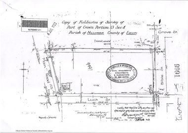
Portion of land bounded by: Main Road, Luck Street, Bible Street, Arthur Street Application 37314 W. P. Steane, M.C.E. Civil Engineer and Surveyor, 18 May 1908application 37314, arthur street, bible street, eltham, luck street, main road, map, survey plan -
 Eltham District Historical Society Inc
Document - Photocopy, Survey Fleld Notes of Part of Crown Portion 13, Section 4 at Eltham, Parish of Nillumbik, County of Evelyn, 31 May 1907
Portion of land east of Main Road and north of Luck Street bounded by Bible Street Application 36708 K. Arndt, Licensed Surveyor, 31 May 1907application 36708, bible street, eltham, luck street, main road, map, survey plan -
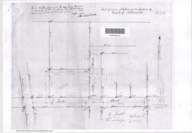
 Eltham District Historical Society Inc
Document - Photocopy, Survey Fleld Notes of Part of Crown Portion 13, Section 4 at Eltham, Parish of Nillumbik, County of Evelyn, November 1909
Portion of land bounded by Main Road, Arthur Street, Bible Street, Henry Street Application 36708 K. Arndt, Licensed Surveyor, November 1909application 5289, arthur street, bible street, eltham, henry street, main road, map, survey plan -
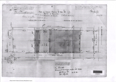 Eltham District Historical Society Inc
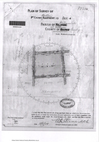
Document - Photocopy, Survey Fleld Notes of Part of Crown Portion 12, Section 4 at Eltham, Parish of Nillumbik, County of Evelyn, 12 October 1910
Portion of land bounded by: Main Road, John Street, Bible Street, Pitt Street Application 38858 K. Arndt, Licensed Surveyor, 12 August 1910application 38858, bible street, eltham, john street, main road, map, pitt street, survey plan -
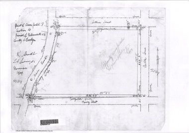
 Eltham District Historical Society Inc
Document - Photocopy, Survey Fleld Notes of Part of Crown Portion 12, Section 4 at Eltham, Parish of Nillumbik, County of Evelyn, 20 May 1911
Portion of land bounded by: Main Road, York Street, Bible Street, Bridge Street Application 38629 Frederick Dudley Smith, M.C.E. Licensed Surveyor, 20 May 1911application 38629, bible street, bridge street, eltham, main road, map, survey plan, york street -
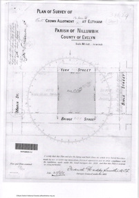
 Eltham District Historical Society Inc
Document - Photocopy, Survey Fleld Notes of Part of Crown Portion 13, Section 4 at Eltham, Parish of Nillumbik, County of Evelyn, 7 January 1924
Portion of land north of Luck Street bounded by: Main Road, Bible Street Application 9991 R. Woodstock, Land Surveyor, 7 January 1924application 9991, bible street, eltham, luck street, main road, map, survey plan -
 Eltham District Historical Society Inc
Document - Photocopy, Survey Fleld Notes of Part of Crown Portion 13, Section 4 at Eltham, Parish of Nillumbik, County of Evelyn, 7 May 1925
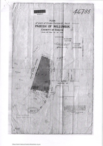
Portion of land bounded by: Main Road, Eltham Railway Station Application 46785 J.T. Robinson, Surveyor, 7 May 1925application 46785, arthur street, bible street, eltham, eltham railway station, luck street, main road, map, survey plan