Showing 320 items
matching farm produce
-
 Warrnambool and District Historical Society Inc.
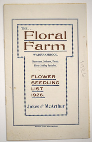
Booklet - Florist Booklet, Modern Print Warrnambool, The Floral Farm Warrnambool Flower Seedling List 1926, 1926
A business booklet of plants for sale and seasonal suggestions for planting.This booklet has sixteen pages with gold and blue printing on the white cover. The pages contain printed material. The pages have been stapled but the staples have been removed.non-fictionA business booklet of plants for sale and seasonal suggestions for planting.warrnambool plant nurseries, charles jukes -
 Warrnambool and District Historical Society Inc.
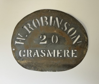
Functional object - Robinson Farm Labelling Stencil, c.1950
This stencil has been made to label packaged produce (wool bales, packaged meat etc) from a farm in Grasmere, near Warrnambool. The name, W. Robinson, suggests that this is William Robinson the son of James and Jane Robinson. James Robinson came to Australia in 1857 and he and his family farmed at Springvale at Hopkins Point, then at what was termed 'Manning's old Purnim Farm' on the Merri Rive at Grasmere (the Manning brothers, Frederick and John were early farmers in the district). The Robinson brothers, James and Stuart were well-known in the Warrnambool district as champion ploughmen. James's son, William married firstly Christina MacLennan and then Elizabeth Neale of Tooram, Allansford. William died in 1959 but the stencil was probably used on the property after his death. This farm stencil is of interest as a memento of farming at Grasmere in the first half of the 20th century.This is a metal stencil, oval in shape. It has letters cut out in the metal for stencilling purposes. It has been painted or sprayed and is rusted in places.W. Robinson 20 Grasmerewilliam robinson grasmere, manning's purnim farm -
 Warrnambool and District Historical Society Inc.
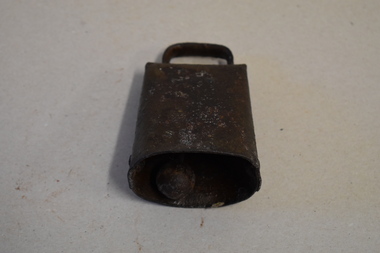
Bell, Cow, Late 19th century
This item was originally made to put around a farm or herd animal to enable it to be identified and found if it strayed. Horses, cows, goats and oxen were the animals most commonly given neck bells in Australia as a way of identifying and finding cattle particularly in areas where prpoerties were unfenced or when droving large herds of mixed cattle. Drovers often marked these bells as a way of identifying which cattle belonged to them. Some of these bells from the 1860's onwards were imported to Australia and some were manufactured locally. The cow bell in various sizes is often still produced to sell to tourists, particularly those in Europe. Many of these souvenir bells contain some form of art work. Although this item has no known local provenance it is retained as an early example of the bells placed around animals’ necks to stop them from straying. This is a piece of metal welded to form a cover or a bell container with a bottom opening to hold a metal clapper which is held in place by a metal ring. The top has a metal handle. The bell is very rusted and stained.animal husbandry, warrnambool, history of warrnambool, cow bell -
 Warrnambool and District Historical Society Inc.
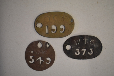
Stencils x 3
Stencils were used to mark produce before it went to markets and/or in transit. Produce such as bales of wool, dairy and fresh produce were so marked and the account credited to the relevant producer. The origins and provenance of the stencils is not known at this time.These stencils have no known provenance but have interpretive interest and significance..1 Oval metal stencil with the number 373 cut out of the metal and with WTC engraved above it. Circular hole in the metal on the left side. .2 Circular metal with 549 cut out of metal and S of W engraved above. One large circle and two smaller circles also cut out of the metal. .3 Oval metal stencil with the numbers 199 cut out of metal and TCW engraved above it. Circular hole has been cut out on the left..1 WTC Old catalogue number on rear 437 .2 S of W Old catalogue number on rear 442 .3 TCW. Old catalogue number on rear.433warrnambool, metal stencils, farm stencils -
 Federation University Historical Collection
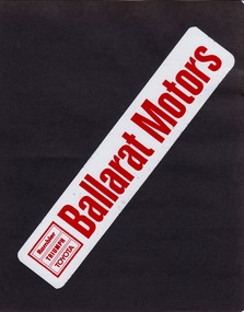
Album - Album - Sample Stickers, ZILLES COLLECTION: Album, Sample Stickers produced by Jeff Zilles
Zilles Printers was begun by Lewis Zilles in the early 1930s. It was in McKenzie Street Ballarat. His son Jeffrey also became a printer - letterpress, offset and screen printer. The business became Zilles Printers/Graphics and was in Armstrong Street and later Bell Street Ballarat. A form of sticker began in 1839 when Sir Rowland Hill invented adhesive paper. The first self-adhesive label was invented in 1935 by Stanton Avery - Avery Labels. In the 1940s "bumper strips"were created. Now referred to as bumper stickers. The stickers shown are for car dealerships, motor bike, tractor and agricultural equipment and entertainment. They are for places in Ballarat, Bendigo, Geelong and Wonthaggi, indicating that Zilles were well known for the quality of their products. These stickers were possibly produced in the 1960s, 1970s and early 1980s. The Swinger was a local dance that ran at the Ballarat Civic Hall between 1972-1975. Dress was neat casual and men were required to wear a tie. The average age of attendees was 18-25.Dark green vinyl cover, three bolts holding it together. Thirteen pages - black cover paperSticker on each pagezilles printers, stickers, bumper stickers, self-adhesive label, santo avery, sir rowland hill, car dealers, motor cycles, farm equipment, ballarat, bendigo, geelong, wonthaggi, ballarat motors, rambler, triumph, toyota, brown murphy geelong, leyland australia, berko datsun geelong, mental ballarat, sound conditioned bendigo, col hawkins, frank faulkner car sales, patron products ballarat, mil haven tractor cab ballarat, john basin ballarat, swinger, b & g myers pty ltd ballarat, arthur shultz, don mullin motors wonthaggi -
 Marysville & District Historical Society
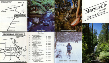
Ephemera (Item) - Tourist Guide, Marysville Tourist Association, Marysville Victoria Be our Guest, Unknown
A fold out tourist guide to Marysville and the surrounding district. This map was produced by the Marysville Tourist Association.A fold out tourist guide to Marysville and the surrounding district.marysville, victoria, australia, tourist guide, steavenson falls, mt cathedral lodge, camelot camel farm, danish coffee garden, marysville country club, crossways country inn, kufstein inn, marysville craft shop, gallery restaurant, the cumberland, tower motel, marysville hotel, scenic motel, fruit salad farm, marylyn guest house, marylands guest house, blackwood lodges, taggerty river, lake mountain -
 Marysville & District Historical Society
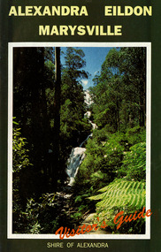
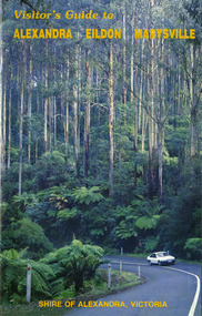
Ephemera (Item) - Visitor's Guide, Shire of Alexandra, ALEXANDRA EILDON MARYSVILLE Visitor's Guide, Unknown
A tourist guide for Alexandra, Eildon and Marysville produced by the Shire of Alexandra.A tourist guide for Alexandra, Eildon and Marysville produced by the Shire of Alexandra.alexandra, eildon, marysville, victoria, australia, tourist guide, steavenson falls, blackwood lodges, marysville hotel motel, the cumberland, gallery restaurant marysville, marysville gallery, cross country ski hire, marylyn guest house, marylands guest house, marysville crafts & gifts, hearts of oak antiques, geoffrey pope & associates, cedron house marysville, amber view holiday lodges marysville, marysville ski hire, lake mountain ski school, fruit salad farm, taggerty general store, arbor green galleries marysville, black spur roadhouse, black spur motel & caravan park, marysville caravan park, the hermitage narbethong, danish coffee garden, maryton park, buxton trout farm, lake mountain outdoor centre marysville, australian bush pioneer's farm, the camel farm and zoo buxton, marysville mountain view horse hire, marysville golf and bowls club, yarrolyn holiday park taggerty, riverland lodge taggerty, beauty spot walk, tree fern gully walk, michaeldene track, keppel track, woods lookout track -
 Marysville & District Historical Society
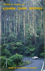
Ephemera (Item) - Visitor's Guide, Shire of Alexandra, Visitor's Guide to ALEXANDRA EILDON MARYSVILLE, Unknown
A tourist guide for Alexandra, Eildon and Marysville produced by the Shire of Alexandra.A tourist guide for Alexandra, Eildon and Marysville produced by the Shire of Alexandra.alexandra, eildon, marysville, victoria, australia, tourist guide, the cumberland, tudor lodge road house, the hermitage narbethong, blue views ski hire and holiday units narbethong, blackwood lodges marysville, marysville hotel motel, kufstein inn marysville, lake mountain, mary-lyn resort marysville, kooringa resort and conference centre marysville, mary's ville marysville, marysville crafts & gifts, geoffrey pope & associates, nanda binya lodge marysville, crossways country inn marysville, steavenson falls, scenic motel, marylands guest house, marysville holiday cottages, marysville newsagency & general store, el kanah, roseleigh holiday units, restaurant tirol, olde yarra track shoppe, marysville caravan park, dalrymples guest cottages, danish coffee garden, maryton park, tower motel, marysville golf and bowls club, taggerty general store, the camel farm and zoo buxton, buxton trout farm, yarrolyn holiday park, riverland lodge, marysville mountain view horse hire, beauty spot walk, tree fern gully walk, michaeldene track, keppel track, woods lookout track -
 Marysville & District Historical Society
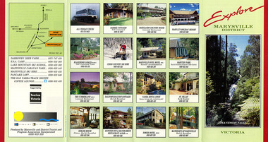
Ephemera (Item) - Information brochure, Marysville and District Tourist and Progress Association, Explore MARYSVILLE DISTRICT, Unknown
An information brochure with photographs of accommodation sites and businesses in Marysville as well as activities to experience in and around Marysville. This brochure was produced by the Marysville & District Tourist & Progress Association with the support of Tourism Victoria.An information brochure with photographs of accommodation sites and businesses in Marysville as well as activities to experience in and around Marysville.Supported by/ Victorian/ Tourism/ Commission Produced by Marysville/ and District Tourist and Progress Association Incorporatedmarysville, victoria, australia, information brochure, all terrain tours, baree cottages, marylands country house, may-yn holiday resort, blackwood lodges, cross country ski hire, marysville hotel motel, maryton park, the cumberland, dalrymples guest cottages, nanda binya lodge, st fillan, kerami house, kufstein inn, silver birch restaurant and bar, tower motel, mathilde's of marysville, steavenson falls, marysville and district tourist and progress association incorporated, tourism victoria, darrowby deer farm, esa camp, lake mountain ski school, marysville caravan park, marysville ski hire, pancake loft, the old yarra track shoppe -
 Marysville & District Historical Society
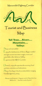
Map (Item) - Tourist and business map, Narbethong Community and Tourism Group, Narbethong Buxton Taggerty Tourist and Business Map, 04-2008
A tourist and business map of Narbethong, Buxton and Taggerty. This map was produced by the Narbethong Community and Tourism Group in April 2008. It was produced to promote the natural attractions, adventure activities and food trail from the Black Spur, through Narbethong, Buxton and Taggerty.A tourist and business map of Narbethong, Buxton and Taggerty.This publication has been produced by the Narbethong Community and Tourism/ Group (NCTG) to promote the natural attractions, adventure activities and food/ trail from the Black Spur, through Narbethong, Buxton and Taggerty./ the information provided in this publication has been supplied by the individual/ members. NCTG takes no responsibility for its accuracy./ April 2008narbethong, buxton, taggerty, victoria, australia, tourist and business map, narbethong community and tourism group, acheron valley, yarra track, wood's point, black spur, mystic mountains, the meeting of the waters, cathedral range, danico design counted cross stitch, things of sand & stone, buxton zoo nursery & oddz & enz, willowbank at taggerty, safe trek 4wd services, pnl 4wdriving, buxton trout and salmon farm, mystic mountains ski hire & outdoors, narbethong ski hire, highwood health centre, cathedral view natural therapies, narby cabinets, plants by shelian, gb timber, executive signs, rb automotive repairs, buxton car care, marysville towing & equipment hire, martyn slade building design, cathedral peak framing, black spur roadhouse & ski hire, tudor lodge roadhouse & ski hire, buxton roadhouse & persian bazzar, buxton post office general store & niche bar, igloo roadhouse, taggerty store, narby eggs, marapana agistment park, mantirri blueberry farm, carmyle farm, hazelwood hazelnuts, south cathedral lavender farm, cathedral cherries, black spur motel & caravan park, woodlands rainforest retreat, chestnut glade, black spur inn, wombat cottage, abbey lake luxury b & b spa cottages, blue views holiday cottages, camp narbethong, marapana farm stay b & b, mantirri blueberry farm b & b, little dene garden cottages, silverstream b & b cottages, nareen cabins, moondai farm b & b, south cathedral farm luxury b & b cottages, yarrolyn caravan park, sarsens rest, lomah retreat, pinjarra gardens, kingbilli country estate, henry viii manor house, buxton hotel, butters cafe of buxton, wagtail wines, little river wines, lanterns at willowbank, wirrawilla rainforest walk, wilhemina falls, the cascades -
 Marysville & District Historical Society
Map (Item) - Tourist and business map, Narbethong Community and Tourism Group, the Gateway TOURIST AND BUSINESS MAP, 08-2009
A tourist and business map of Narbethong, Buxton, and Taggerty. This map was produced by the Narbethong Community and Tourism Group Inc in August 2009. It was produced to promote the natural attractions, adventure activities, and food trail from the Black Spur, through Narbethong, Buxton, and Taggerty.A tourist and business map of Narbethong, Buxton and Taggerty.This publication has been produced by the Narbethong Community and Tourism Group Inc./ (NCTG) The information provided in this publication has been supplied by the individual/ members. NCTG takes no responsibility for its accuracy./ August 2009narbethong, buxton, taggerty, victoria, australia, tourist and business map, the gateway tourist and business map, black spur motel & caravan park, woodlands rainforest retreat, chestnut glade, black spur inn, wombat cottage, abbey lake luxury b&b spa cottages, camp narbethong, marapana farm stay b&b, mantirri b&b, little dene garden cottages, nareen cabins, silverstream b&b cottages, buxton hotel motel, south cathedral farm luxury b&b cottages, cathedral view b&b retreat, kingbilli country estate, cathedral valley farm, pinjarra gardens, willowbank at taggerty, sarsens rest, yarrolyn caravan park, danico design counted cross stitch, things of sand & stone, buxton zoo nursery, safetrek 4wd services, mystic mountains ski hire & outdoors, pnl 4wdriving, buxton trout and salmon farm, buxton bait and tackle, black spur roadhouse, tudor lodge service station roadhouse & ski hire, buxton roadhouse, buxton p.o. general store, igloo roadhouse, henry v111 manor house, buxton hotel, butters cafe, wagtail wines, little river wines, narby eggs, marapana agistment park, carmyle farm, hazelwood hazelnuts, cathedral view naturall therapies, cre8ing growth, linda hailey, naby cabinets, gb timber, narbethong timber & trading, rb automotive repairs, buxton car care, martyn slade building design, taggerty vet clinic -
 Marysville & District Historical Society
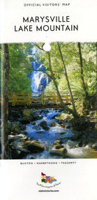
Map (Item) - Tourist map, Mystic Mountains Tourism, OFFICIAL VISITORS' MAP MARYSVILLE LAKE MOUNTAIN, Unknown
A visitors' map of Marysville and Lake Mountain produced by Mystic Mountains Tourism for Visit Victoria.A visitors' map of Marysville and Lake Mountain produced by Mystic Mountains Tourism for Visit Victoria.The Marysville and Lake Mountain Visitor Map and Touring Guide has been compiled and/ published by Mystic Mountains Tourism Inc. Copyright./ Production and artwork Graph Attack P/Lmarysville, lake mountain, victoria, australia, visitor's map, official visitors' map marysville lake mountain, buxton, narbethong, taggerty, visit victoria, mystic mountains tourism inc, graph attack p/l, mystic mountains, marysville triangle, marysville visitor information centre, marylands country house, black spur, steavenson falls, lady talbot drive, cambarville, cathedral ranges, wirreanda festival, lake mountain summit walk, summit walk loop, leadbeaters loop, day loop walk, buxton hotel, igloo roadhouse, karmann waters, silverstream b&b cottages, buxton trout and salmon farm, the niche wine bar, buxton post office & general store, choppers buxton roadhouse, woodlands rainforest bungalows, chestnut glade, black spur inn, wombat cottage, abbey lake luxury b&b spa cottages, mystic mountain ski hire & outdoors, pnl 4wdriving, blue views holiday units & ski hire, marapana agistment park & farm stay b&b, danico design, things of sand & stone, mantirri blueberry farm, allawah country cottages, amberview cottages, ashlar cottage b&b, black spur motel & caravan park, blackwood deluxe cottages, blackwood courtyard b&b, dalrymples guest cottages, delderfield, el kanah guest house, fruit salad farm, kerami guest house, keppels hotel, lake mountain-snow gum lodge, lomatia lodge, lyell guest cottages, magnolia house, keppel waters, lyrebird apartments, marysville caravan park, all view spa apartments, riverside cottages, maryton park b&b country cottages, melina cottage, mountain lodge, mystic mountains holiday cottages, nanda binya lodge, rendezvous luxury cottages, scenic b&b motel, the cumberland, south cathedral farm, tower motel, willowbank at taggerty, woodlands rainforest retreat, marysville & district country club inc, mystic mountains ski hire & outdoors, rubicon valley horse riding, marysville trout and salmon ponds, gallipoli park, keppels lookout, cambarville-yarra ranges national park, lake mountain-yarra ranges national park, lady talbot drive-yarra ranges national park, cathedral range state park, steavenson river, taggerty river, acheron river, lake mountain alpine resort, bruno's art and sculpture garden, manical mechanicals, uncle fred & aunty val's old style lolly shop, carmyle farm boutique, crossways historic country inn, fraga's, gilberts restaurant, heights licensed bistro, the old woolshed cafe, cathedral view natural therapies, crystal journey -
 Marysville & District Historical Society
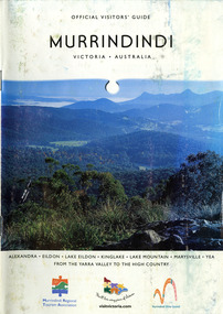
Booklet (Item) - Information booklet, Alexandra Newspapers, OFFICIAL VISITORS' GUIDE MURRINDINDI VICTORIA-AUSTRALIA, 03-2005
An information booklet on the Murrindindi region in Victoria. This information booklet was produced by Alexandra Newspapers in partnership with the Murrindindi Regional Tourism Association in March 2005.An information booklet on the Murrindindi region in Victoria.Produced and published by Alexandra Newspapers/ Pty Ltd in partnership with the Murrindindi Regional/ Tourism Association. murrindindi, victoria, australia, alexandra, eildon, kinglake, marysville, yea, yarra valley, high country, visit victoria, alexandra newspapers, murrindindi tourism association, rubicon valley horse riding, cathedral range state park, murrindindi scenic reserve, yarra ranges national park, cumberland memorial scenic reserve, the big culvert, cambarville, the big tree, steavenson falls, cora lynn falls, cumberland falls, lady talbot drive, phantom falls, keppel falls, the beeches, the cascades, wilhelmina falls, murrindindi cascades, lake mountain, cathedral lane vineyard, south cathedral farm, marysville holiday cottages, crystal journey, country touch, marysville ski centre, mountain lodge marysville, eco adventure tours, the mountain gallery, marysville country real estate, camellia log cabin, crossways historic country inn, marylands country house, ashlar cottage b&b, kerami guesthouse, melina cottages, willowbank at taggerty, mary lyn holiday resort, kooringa resort & conference centre, marysville caravan & holiday park, lyell guest cottages, eagle mountain retreat, keppels hotel motel, anastasia fairytale cottage, mystic mountain holiday cottages, esa camping & conference centre, buxton trout & salmon farm, woodlands rainforest bungalows, the old woolshed cafe, yarrolyn holiday park -
 Marysville & District Historical Society
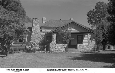
Postcard (Item) - Black and white postcard, Rose Stereograph Company, 1913-1967
A black and white postcard of Buxton Farm Guest House near Marysville. This postcard was produced by Rose Stereograph Company as a souvenir of Marysville.A black and white postcard of Buxton Farm Guest House near Marysville.THE ROSE SERIES P. 1847/ COPYRIGHT BUXTON FARM GUEST HOUSE, MARYSVILLE, VIC.marysville, victoria, australia, buxton farm, buxton farm guest house, rose series, p. 1847, postcard, souvenir, rose stereograph company -
 Marysville & District Historical Society
Ephemera (Item) - Information flyer, Artworkz Tourism, Buxton Trout & Salmon Farm, Unknown
A digital copy of an information flyer that was produced as a guide to Buxton Trout & Salmon Farm in Victoria.A digital copy of an information flyer that was produced as a guide to Buxton Trout & Salmon Farm in Victoria. Buxton Trout and Salmon Farm was established in 1958 and is Australia's first commercial trout farm where trout have been reared for over 50 years.buxton, victoria, buxton trout and salmon farm, advertising brochure, brochure, trout, salmon -
Federation University Historical Collection
Document - Document - Syllabus, Education Department, Victoria, Syllabuses, Technical Schools, 1921 and 1924
Syllabuses produced by the Education Department of Victoria. They are for Technical Schools and outline requirements for various subjects. They were produced at the beginning of each year. .1, .2, .3 are for 1921. .4 to .22 are for 1924. .1: Mechanics and Mechanics Applied to Mining (1921) .2: Mechanics and Heat (1921) .3: Graphics (1921) .4: Hydraulics (1924) .5: Civil Engineering (1924) .6: Electrical Technology (1924) .7: Electric Wiring (1924) .8: Sheet Metal Work, Pattern Cutting for Tinsmiths, Galvanized Iron Workers and Sheet Copper Workers (1924) .9: Metal Work (Machine Shop Practice) (1924) .10: Farm Irrigation and Irrigation Engineering .11: Food Analysis .12: Theory of Aircraft Design and Construction (1924) .13: Iron, Steel and Engineering Alloys (Special Course for Aeronautical Engineers) (1924) .14: Civil Engineering (1924) .15: Diploma Students - Iron, Steel and Engineering Alloys (1924) .16: Aerodynamics (1924) .17: Electrical Engineering (1914) .18: Mechanical Drawing, 2nd Year Students - Junior Technical Schools (1924) .19: Mechanical Drawing, 3rd Year Students - Junior Technical Schools or Preparatory Evening Course for Technical School Students (1924) .20: Mathematics (1924) .21: Diploma Courses in Engineering - Electrical, Mechanical, Marine, Civil, Aeronautical (1924) .22: Civil Engineering (1924) 22 items, A5 in size. Some are folded sheets of A4 paper.sylabus, education department, victoria, technical schools, 1921, 1924, mechanic and mechanics applied to mining, mechanis and heat, graphics, hydraulics, civil engineering, electrical technology, electric wiring, sheet metal work, pattern cutting for tinsmiths, galvanised iron workers, sheet copper workers, machine shop practice, farm irrigation, irrigation engineering, food analysis, theory of aircraft design and construction, aeronautical engineers, diploma students, aerodynamics, electrical engineering, mechanical engineering, mechanical drawing, junior technical schools, evening course for technical students, mathematics -
 Flagstaff Hill Maritime Museum and Village
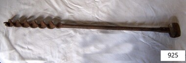
Tool - Scotch Eye Beam Auger, W M Ridgway, 1930s
William Ridgway and Sons company of Sheffield, manufacturers of augers, bits, wood-boring, and motorising tools, was founded in 1878 and became a Private company in 1909, their factory was founded in the 1930s. William Ridgway Tools merged first with Record Tools in 1974 to form Record Ridgway Tools Ltd. Record was another Sheffield company that was renowned for the quality of their vices and industrial clamps. Following the merger Record, Ridgway Tools Ltd was made up of fourteen UK Companies and five overseas companies. A later merger with a woodwork tools company called Marple (which was part-owned by Record and Ridgway respectively before their original merger) led to the company becoming known as Record Marples Tools. Record Marples was taken over by the Swedish hardware manufacturer AB Bahco in 1982. Despite a management buyout leading to the company reverting to British ownership in 1985 the company struggled financially and the following administration was acquired by U.S.-based Irwin Tools in 1998 who has since moved production to China in recent years. A vintage tool made in the 1930s when Ridgway began mass producing augers and other tools for export and sale. This item would have probably been used in Australia on a farm for drilling fence posts for wire to pass through or other tasks where a hole was required to be bored in timber. Scotch eye beam auger, with double twist and Lead screw. Ridgway Sheffield flagstaff hill, warrnambool, flagstaff-hill-maritime-museum, maritime-museum, shipwreck-coast, flagstaff-hill-maritime-village, ridgway & sons, wood boring tool, carpenters tools, coopers tools, marine tools -
 Flagstaff Hill Maritime Museum and Village
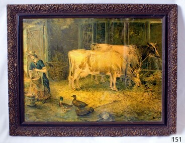
Print - Picture
This picture was produced affordably for domestic decoration in the early to the mid-20th century. The picture is currently not associated with a historical event, person or place at this time and is being used to augment Flagstaff's village display.Picture of cattle, ducks and woman pouring milk in barn. Colour print on grainy paper covered by glass with decorative gilt frame. flagstaff hill, warrnambool, shipwrecked coast, flagstaff hill maritime museum, flagstaff hill maritime village, great ocean road, print, wall decoration, art, farm scene -
 Eltham District Historical Society Inc
Photograph, Edendale Farm, Eltham Heritage Tour, 24 May 1992, 24/05/1992
ELTHAM HERITAGE TOUR The Society excursion on 24th May 1992 was arranged by David Bick, leader of the team carrying out the Shire's heritage study. David selected a number of sites or buildings identified in the study, some of them lesser known components of the Shire's heritage. The tour commenced at the Eltham Shire Office at 10.00 am. Travel was by private car and mini-bus with stops at about twelve locations for commentary by David.It included a short walk in Hurstbridge and lunch at Kinglake. Highlights of the tour included: - 10 am Leave from Shire Offices - 3 Important Trees - A Physical Link to Eltham's First Settlers - Toorak Mansion Gates - A Surviving Farm House - An Intact Circa 1900 Main Street - First Settlers - Gold Miners, and Timber-getters - An Early Hotel - A Pioneering Homestead - Changing Eltham Shire - 20th Century - 4 pm Afternoon Tea and Finish Tour Extract from ELTHAM CULTURAL HERITAGE TOUR (Newsletter No. 85, July 1992, by Bettina Woodburn) "The land was unprofitable for intensive farming, but there was always water in the Diamond Creek. The railway, a technological advance, followed the valley, and was provided to transport produce. At North Eltham we were privileged to tour a surviving farmhouse of the 1860-70 era at the Shire’s Edendale Farm, with the as yet unfinished Sculpture for a front fence - bulbous tree-trunks decorated with salt pots, with cross members from the old trestle bridge. As was usual these six veranda posted houses faced South (or East, away from the sun!) with the scullery, kitchen and pantry "out the back". The veranda, which must have been very narrow, no longer exists. It probably wrapped around three sides. The drive took us past the Dutch Windmill, only twenty years old and in the Shire of Diamond Valley, then the Diamond Creek Cemetery with impressive gateway, to a detour to see another old farmhouse, isolated on a hill off Murray Road Wattle Glen. Here was a particularly thick patch of exotic planting of pines and cypresses. Subsistence farming no longer pays. Following the rail-line we noticed on the left near Silvan Road an Edwardian cottage and on the right near Yates Road the old school residence for this Upper Diamond Creek area."Record of the Society's history and activities and highlighting various aspects of the Heritage Study undertaken by David Bick used to create the future heritage overlay for the Shire of Eltham and later Nillumbik Shire.Roll of 35mm colour negative film, 4 stripsKodak Gold 100 5095eltham, shire of eltham historical society, activities, heritage tour -
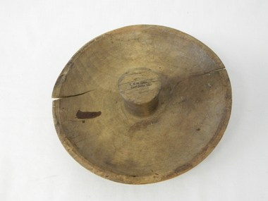 Kiewa Valley Historical Society
Mould Butter, unknown, post 1967
... produce in the 1980s saw a greater demand of this type of farm ...This butter mould/pat may have been manufactured post 1967(year post codes appeared in Australia) however the post code was only stamped on after it was machined. This type of butter mould was used by rural families to fashion home/farm made butter. This period was in most rural regions a time of self sufficiency where any domestic type implement which could be fashioned by the family would be crafted with skill. Shopping for goods required catalogues from stores located in major rural towns and cities and involved lengthy waiting times. Travelling to and from these specialised stores was not pleasant due to the relatively poor quality of the roads and the lengthy times taken. The small general stores in the Kiewa Valley could not cater for all the needs of the valley. The 1960's was a time when facilities especially goods and services started to improve drastically. The S.E.C. of Victoria with its Kiewa Hydro Electricity Scheme provided not only an improvement of facilities in the valley but also a increase in the population. This increase resulted in a greater demand for local produce. This item is one of many domestic food processing implements used by Kiewa Valley households in the mid 1900s, whether on the farm or in the small towns and hamlets. Self sufficiency was the key to survival during these early times. Where ever possible supplies from within the valley were preferred to that brought in by travelling salesmen or traders. This butter mould and butter pat was commonly used to fashion "home" made butter throughout the valley and in some cases supplied to "outside" regional towns. Although this method of production was phased out by better access to goods from nearby cities the revival of the good organic home grown produce in the 1980s saw a greater demand of this type of farm based produce.This well crafted circular wooden butter mould could also be used as a butter pat.The handle in the middle of the mould was not added after the crafting but has been fashioned from the initial block of wood when the bowl was crafted. The bowl structure has a rim around the edge.The top of the handle has an ink stamp "T. & W. Dav" on the top line and "Tawonga 3697" underneath.domestic food preparation, wooden butter pat, butter mould circular, dairy industry -
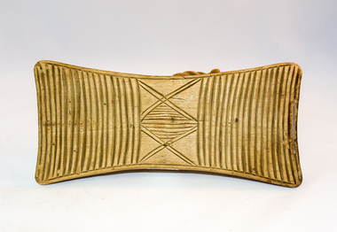 Kiewa Valley Historical Society
Pat Butter Profiler, Circa 1950s
... produce in the 1980s saw a greater demand of this type of farm ...This butter pat profiler may have been manufactured post 1967(year post codes appeared in Australia) however the post code was only stamped on after it was machined. This type of butter mould was used by rural families to fashion home/farm made butter. This period was in most rural regions a time of self sufficiency where any domestic type implement which could be fashioned by the family would be crafted with skill. Shopping for goods required catalogues from stores located in major rural towns and cities and involved lengthy waiting times. Travelling to and from these specialised stores was not pleasant due to the relatively poor quality of the roads and the lengthy times taken. The small general stores in the Kiewa Valley could not cater for all the needs of the valley. The 1960's was a time when facilities especially goods and services started to improve drastically. The S.E.C. of Victoria with its Kiewa Hydro Electricity Scheme provided not only an improvement of facilities in the valley but also a increase in the population. This increase resulted in a greater demand for local produce.This item is one of many domestic food processing implements used by Kiewa Valley households in the mid 1900s, whether on the farm or in the small towns and hamlets. Self sufficiency was the key to survival during these early times. Where ever possible supplies from within the valley were preferred to that brought in by travelling salesmen or traders. This butter mould and butter pat was commonly used to fashion "home" made butter throughout the valley and in some cases supplied to "outside" regional towns. Although this method of production was phased out by better access to goods from nearby cities the revival of the good organic home grown produce in the 1980s saw a greater demand of this type of farm based produce.This butter Pat/Profiler has on its base two patterns. On each end it has horizontal grooves cut into the wood which produce distinct lines onto the surface of the butter. between these grooves there is a section of two double lines crossing in the middle and separated by eleven horizontal lines The base has an elongated rectangular shape. The upper body has been sanded into a smooth convex shaped form where a wooden circular hand grip has been fashioned.On the top of the hand grip is stamped in black print"T. & W. Davies" and under this"TAWONGA 3697"domestic food preparation, wooden butter pat, butter mould circular, dairy industry -
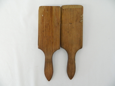 Kiewa Valley Historical Society
Pat Butter, Circa 1950
... produce in the 1980s saw a greater demand of this type of farm ...This butter pat profiler may have been manufactured post 1967 (year post codes appeared in Australia) however the post code was only stamped on after it was machined. This type of butter mould was used by rural families to fashion home/farm made butter. This period was in most rural regions a time of self sufficiency where any domestic type implement which could be fashioned by the family would be crafted with skill. Shopping for goods required catalogues from stores located in major rural towns and cities and involved lengthy waiting times. Travelling to and from these specialised stores was not pleasant due to the relatively poor quality of the roads and the lengthy times taken. The small general stores in the Kiewa Valley could not cater for all the needs of the valley. The 1960's was a time when facilities especially goods and services started to improve drastically. The S.E.C. of Victoria with its Kiewa Hydro Electricity Scheme provided not only an improvement of facilities in the valley but also a increase in the population. This increase resulted in a greater demand for local produce.This item is one of many domestic food processing implements used by Kiewa Valley households in the mid 1900s, whether on the farm or in the small towns and hamlets. Self sufficiency was the key to survival during these early times. Where ever possible supplies from within the valley were preferred to that brought in by travelling salesmen or traders. This butter mould and butter pat was commonly used to fashion "home" made butter throughout the valley and in some cases supplied to "outside" regional towns. Although this method of production was phased out by better access to goods from nearby cities the revival of the good organic home grown produce in the 1980s saw a greater demand of this type of farm based produce.This butter pat is one of two,see KVHS 0071 (B). It has been crafted from wood. One side has grooves running from the handle to the square shaped bottom. These grooves would stop the wet butter from clinging to the pat. The top side of the pat has been bevelled on both sides and the bottom edge. The hand grip is flat and curved to allow for a comfortable hold.domestic food preparation, wooden butter pat, butter mould circular, dairy industry, butter -
 Kiewa Valley Historical Society
Pat Butter Profiler, Circa 1950
... produce in the 1980s saw a greater demand of this type of farm ...This butter pat profiler may have been manufactured post 1967(year post codes appeared in Australia) however the post code was only stamped on after it was machined. This type of butter mould was used by rural families to fashion home/farm made butter. This period was in most rural regions a time of self sufficiency where any domestic type implement which could be fashioned by the family would be crafted with skill. Shopping for goods required catalogues from stores located in major rural towns and cities and involved lengthy waiting times. Travelling to and from these specialised stores was not pleasant due to the relatively poor quality of the roads and the lengthy times taken. The small general stores in the Kiewa Valley could not cater for all the needs of the valley. The 1960's was a time when facilities especially goods and services started to improve drastically. The S.E.C. of Victoria with its Kiewa Hydro Electricity Scheme provided not only an improvement of facilities in the valley but also a increase in the population. This increase resulted in a greater demand for local produce.This item is one of many domestic food processing implements used by Kiewa Valley households in the mid 1900s, whether on the farm or in the small towns and hamlets. Self sufficiency was the key to survival during these early times. Where ever possible supplies from within the valley were preferred to that brought in by travelling salesmen or traders. This butter mould and butter pat was commonly used to fashion "home" made butter throughout the valley and in some cases supplied to "outside" regional towns. Although this method of production was phased out by better access to goods from nearby cities the revival of the good organic home grown produce in the 1980s saw a greater demand of this type of farm based produce.This butter pat is one of two,see KVHS 0071 (A). It has been crafted from wood. One side has grooves running from the handle to the square shaped bottom. These grooves would stop the wet butter from clinging to the pat. The top side of the pat has been bevelled on both sides and the bottom edge. The hand grip is flat and curved to allow for a comfortable hold.domestic food preparation, wooden butter pat, butter mould circular, dairy industry -
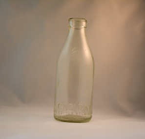 Kiewa Valley Historical Society
Bottle Milk, early 1900's
This glass milk bottle was manufactured and used mid to late 1900's (1834 Victorian dairy industry was founded) up to the time that a cheaper container was invented(plastic bottles and polyethylene plastic lined cardboard cartons) and produced. In 1909 the supply of pure bottled milk was required for babies to overcome infant mortality due to unhygienic milk sources (unclean containers and unpasteurized milk). Due to the volume of milk being processed and hand milking could not keep up with demand, dairy farms introduced milking machines in the late 1930's. The great increases in dairy herds from the average of 18 cows per heard in 1950's to 142 cows per herd in 1996 required milk tankers to pick up the regions milk supply. This bottle was so constructed to be easily moved within the milk processing plants from the delivery vats/holding tanks to the final corking/sealing of the bottles for eventual distribution. From 1958 the milk bottle slowly became phased out of production. At this point in time Melbourne was drawing 160,000 bottles per week from the two major glass bottle works companies, e.g. Melbourne Glass Bottle Works Co. Victoria was the major state supplier of cows milk in the history of Australian milk production from the early 1800's. The Kiewa Valley and its region was a major contributor to meet that demand. Each bottle was "branded" during manufacturing to show the contents (pasteurized milk) and where it originated from (region and supplier). This method of recycling the bottles back to specific dairy farms was a good control method but an uneconomical "on cost" which was replaced by the "throw away" less costly plastic and cardboard containers. Kiewa Valley dairy herds had marked bottles bearing "90/9", "6/18", "6/33", "6/35" and "6/36" This heavy gauged glass milk bottle has a rim and a distinctive head at the top. This head has been manufactured to facilitate the movement of the bottled along the milk production line. The method of pouring milk into the bottle has been part of the "production line". This bottle has a one pint capacity and is made from "clear" glass. There are other milk bottles that have a "green" tint in them.Around the bottom side of the bottle and blown into the glass "ONE PINT" and on the opposite side "MILK". Below these markings is "This BOTTLE BELONGS TO MILK BOTTLES RECOVERY LTD" below this "AND CANNOT BE USED WITHOUT WRITTEN PERMISSION. On the base of the bottle is molded a big "M". An identification mark of "90" over "9" is beneath the "M". glass bottles, commercial milk containers, domestic milk bottles, pasteurized milk bottles, milk, dairy, farms, kiewa valley -
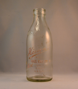 Kiewa Valley Historical Society
Bottle Milk, Circa mid to late 1900's
This glass milk bottle was manufactured and used mid to late 1900's (1834 Victorian dairy industry was founded) up to the time that a cheaper container was invented(plastic bottles and polyethylene plastic lined cardboard cartons) and produced. In 1909 the supply of pure bottled milk was required for babies to overcome infant mortality due to unhygienic milk sources (unclean containers and unpasteurized milk). Due to the volume of milk being processed and hand milking could not keep up with demand, dairy farms introduced milking machines in the late 1930's. The great increases in dairy herds from the average of 18 cows per heard in 1950's to 142 cows per herd in 1996 required milk tankers to pick up the regions milk supply. This bottle was so constructed to be easily moved within the milk processing plants from the delivery vats/holding tanks to the final corking/sealing of the bottles for eventual distribution. From 1958 the milk bottle slowly became phased out of production. At this point in time Melbourne was drawing 160,000 bottles per week from the two major glass bottle works companies, e.g. Melbourne Glass Bottle Works Co. Victoria was the major state supplier of cows milk in the history of Australian milk production from the early 1800's. The Kiewa Valley and its region was a major contributor to meet that demand. Each bottle was "branded" during manufacturing to show the contents (pasteurized milk) and where it originated from (region and supplier). This method of recycling the bottles back to specific dairy farms was a good control method but an uneconomical "on cost" which was replaced by the "throw away" less costly plastic and cardboard containers. Kiewa Valley dairy herds had marked bottles bearing "90/9", "6/18", "6/33", "6/35" and "6/36" This particular one has "7/14".This heavy gauged glass milk bottle has a rim and a distinctive head at the top. This head has been manufactured to facilitate the movement of the bottled along the milk production line. The method of pouring milk into the bottle has been part of the "production line". This bottle has a one Imperial pint capacity and is made from "clear" glass. There are other milk bottles that have a "green" tint in them. Around the bottom side of the bottle and blown into the glass "ONE IMPERIAL PINT". Below these markings and stenciled is "KIEWA" (in freehand style and underlined) underneath is "PASTEURISED FULL CREAM MILK" underneath this ,in freehand stiyle is "USE" next to this in block style "KIEWA BUTTER, CREAM, AND ICE CREAM MIX" to the left of this ,and barely readable is stenciled "THIS BOTTLE ALWAYS REMAINS/ THE PROPERTY OF/ NORTH EASTERN DAIRY Co. Ltd". On the base of the bottle is molded a big "2". with a smaller "m". An identification mark of "7" over "14" is within a circled boundary. Below this is moulded "RM - 15". glass bottles, commercial milk containers, domestic milk bottles, pasteurized milk bottles