Showing 86 items matching "fish shops"
-
 Ballaarat Mechanics' Institute (BMI Ballarat)
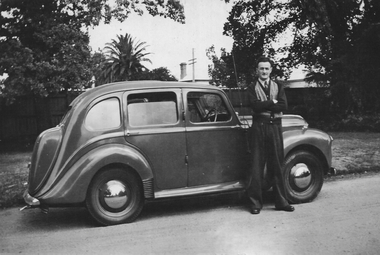
Ron Smith with car (owned fish shop at 1 Victoria St)
... Ron Smith with car (owned fish shop at 1 Victoria St)... Ron Smith with car (owned fish shop at 1 Victoria St) ...This photograph is from the Max Harris Collection held by the Ballaraat Mechanics' Institute. Please contact BMI for all print and usage inquiries.ballarat, cars, ron smith -
 Bendigo Historical Society Inc.
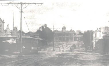
Photograph - HARRY BIGGS COLLECTION: EAGLEHAWK RD, EAGLEHAWK
... . Some people can be seen crossing the tram tracks. One shop... people can be seen crossing the tram tracks. One shop sign ...Photograph. Harry Biggs Collection. Very dark black & white photo of main street, Eaglehawk. Tram in foreground. Some people can be seen crossing the tram tracks. One shop sign is Fish oyster saloon. Very ornate power pole.photograph, streetscape, eaglehawk, harry biggs collection, eaglehawk rd., eaglehawk -
 Stawell Historical Society Inc
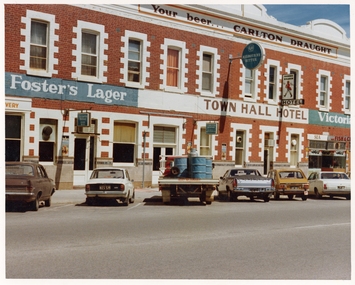
Photograph, Pleasant Creek Special School, Town Hall Hotel, Fish & Chip Shop Nov 1975, Nov 1975
... Town Hall Hotel, Fish & Chip Shop Nov 1975... Street. Town Hall Hotel, Fish & Chip Shop Nov 1975 Photograph ...Photographs taken by teacher at Pleasant Creek Training Centre to help train students in living skills and becoming familiar with what shops sold. Part of socializing students for leaving the training centre.Main Street Stawell. Showing shops and businesses in Main Street. education, shops, main street, streetscape -
 Ballarat Tramway Museum
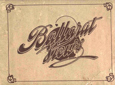
Book, Baxter & Stubbs, "Ballarat Views", 1920's
Yields information about Ballarat through pictures of the 1910-1920's various locations, institutions and street scenes, including tramways and railways.Twenty four page book within light brown covers, titled "Ballarat Views". Sheets, other than covers have been individually printed both sides, stapled within the covers. Cover - gives title, rear cover has printer details - Baxter and Stubbs. Pages 1 - Tonner Memorial , Fountain Lake Wendouree, Ballarat District Hospital, Sturt St south side at Grenville St with tram in distance and Sturt St North Side showing shops (image btm3900i2.jpg). 2 - Ballarat Street Scenes - Sturt Streets, Lydiard St with ESCo 18 in view, and Railway station with R193 in platform on passenger train. (image btm3900i3.jpg). 3 - Lake Wendouree views. 4 - Lake Wendouree, fish hatchery, Gardens and Sturt St at Dawson St (image btm3900i4.jpg). 5 - Art Gallery Ballarat 6 - Botanical Gardens 7 - Public Institution s- Benevolent asylum, Orphanage, Nazareth House, St Joseph Home, Hospital 8 & 9 - Statues, the Flight from Pompeii and others. 10 & 11 - Churches of Ballarat 12 - The Arch at The Avenue of Honour 13 - McDonald Pergola at the Gardens 14 - Zoological Gardens Ballarat 15 - Gardens aerial view and gates at the South End with tram in the distance (image btm3900i5.jpg). 16 - Some views in Ballarat East - Eureka Stockade, Ballarat East Bowling Green, Bridge St looking east and the lake at the Eureka Gardens (image btm3900i6.jpg). 17 - Snow Scene at Botanical Gardens, Begonia House 18 & 19 - Ballarat Water supply reservoirs 20 - Ballarat State Schools 21 - Ballarat East Views, includes view of track in Victoria St looking east (image btm3900i7.jpg). 22 - Views of the Water Reserves 23 - Views about the City - includes City fire station , agricultural High School, City Baths and View Point. 24 - Views at Lake Wendouree. \ Pdf copy of full book added 8/5/2019 - see btm3900i9.pdf trams, tramways, ballarat, lydiard st, sturt st, gardens, railway station, hospital, lake wendouree, wendouree parade, carlton st, esco -
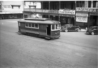 Ballarat Tramway Museum
Negative, Wal Jack, late 1940's or early 1950's
Yields information about the tram services and the lower section of Sturt St.Negative and Digital image of the Wal Jack Ballarat Negative file of No. 27 with the destination Depot via Ripon St. Note the white painted windows. Photo late 1940's or early 1950's. In the background are Paterson's Furniture Providers, Taylor and Taylor Chemists, Ballarat Fish Supply and The Ballarat Ritzy Cafe and Grill Rooms. The chemist shop has a sign for Kodak Film.trams, tramways, sturt st, tram 27 -
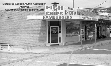 Mordialloc College Alumni Association Inc (MCAA)
Photograph, 1981 Station Street Aspendale fish and chip shop - corner Lawrence Avenue, 1981
... 1981 Station Street Aspendale fish and chip shop - corner... Street Aspendale melbourne 1981 Station Street Aspendale fish ... -
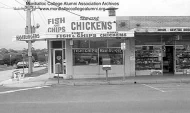 Mordialloc College Alumni Association Inc (MCAA)
Photograph, 1981 - Aspendale shopping centre - fish and chip shop, Van Der Zypp’s newsagency and corner of Lawrence Avenue, 1981
... 1981 - Aspendale shopping centre - fish and chip shop, Van... - fish and chip shop, Van Der Zypp’s newsagency and corner ... -
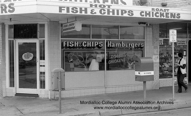 Mordialloc College Alumni Association Inc (MCAA)
Photograph, 1981 - Aspendale shopping centre - fish and chip shop - corner Lawrence Avenue, 1981
... 1981 - Aspendale shopping centre - fish and chip shop... - fish and chip shop - corner Lawrence Avenue Photograph ... -
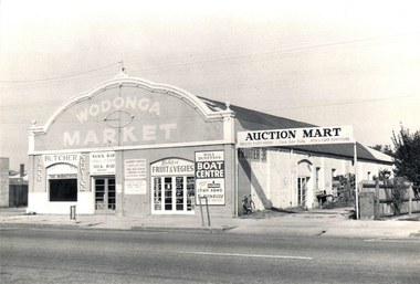 Wodonga & District Historical Society Inc
Photograph - Mann Collection Album - Wodonga Market, C. 1960s
Elaine Mann was married to David Mann, a successful Wodonga businessman and community leader who passed away in Wodonga in June 2012. David was a member of the Mann family who began their business in Wodonga in 1920. Elaine was a teacher in Wodonga for many years and an active member of the community.This photo collection is of significance as it documents how the businesses and buildings in Wodonga have evolved and contributed to community throughout the late 20th century.This building was erected in the 1890's. It was originally the premises of the Federal Coach Factory, then Buntz's Garage, and became Mylon's Garage. July 1960 saw it open as Wodonga Market. An article in Wodonga and District Express dated 1 July 1960 announced: “Wodonga’s New Market Open Today” Arcade Style Shopping "Wodonga’s new market will be open as from morning trade today. Modelled on current overseas open marketing ideas, the new business is similar to the Albury Market in David Street. The Manager (Mr. Ned Day) said yesterday that shops and stalls were sub-let to tenants for a “co-operative rent” which enabled the market to pass these advantages on to the people in lower prices. The building would lend itself to the arcade style which made attractive presentation and would also assist the customer to make quick purchases. There was over 5000 square feet of shopping space.” Businesses open that day were Gerecke’s with a display of secondhand furniture and fittings, and a poultry mart to open the following Friday. Also Webster’s Fruit and Vegetables. Mr. Ned Day advertised space for a variety of listed business types. Businesses recognised in the photo include a Butcher, Webster's Fruit & Vegies, Bill Dunstan's Boat Centre. Snack Bar/Fish & Chips/Milk Bar Auction Mart, New & Used Furniture. Poultry was also available every Friday. The building was demolished in 1963.wodonga businesses, high st wodonga, wodonga market, auction mart -
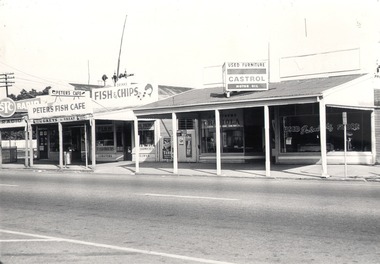 Wodonga & District Historical Society Inc
Photograph - Mann Collection Album - High Street West - Vee Jay Radio, Peter’s Fish Café, Jim Matthews Store, C.1970s
Elaine Mann was married to David Mann, a successful Wodonga businessman and community leader who passed away in Wodonga in June 2012. David was a member of the Mann family who began their business in Wodonga in 1920. Elaine was a teacher in Wodonga for many years and an active member of the community.This photo collection is of significance as it documents how the businesses and buildings in Wodonga have evolved and contributed to community throughout the late 20th century.These businesses were located just north of the railway crossing between Melbourne Road and Bond Street. The railway signals can be seen in the background above Peter’s Fish Café. These buildings have all been demolished and the area is now part of Junction place. Jim Matthews was selling Radiola car radios. He also sold used furniture and had a bike repair business at this location, before later expanding his bike business on the south of the railway crossing, Peters Cafe was at 103 High Street. It was operated by the Bouteris family in the early 1970s. It later became the Chao Thai Restaurant. Vee Jay Radio was operated by Mr. Albert Eddie Branwhite. He moved to Wodonga in 1946 and started selling radio repairs door to door. He then set up his store in 105 High Street. This site had previously been a barber’s shop. The business involved electrical repairs and appliance sales. In the late 1950s Mr. Branwhite established the Wodonga Express. He set the type and printed from the back of this shop until relocating to the Lincoln Causeway. He was actively involved in the community, including many years on the Wodonga Hospital Board of Management which was recognised with a life governorship. Mr. Branwhite passed away in 2001, wodonga businesses, high st wodonga, vee jay radio, jim matthews, peter’s fish café, mr. albert eddie branwhite -
 City of Kingston
Photograph - Colour, 31 January 1993
Patterson Lakes is a suburb in the City of Kingston that is built one kilometre upstream of the mouth of the Patterson River. The area is bordered by the Patterson River and Eel Race Drain which enters the Kananook Creek. The suburb consists predominantly of newer housing developments and the tidal canal system of the development joins Port Phillip Bay. Patterson Lakes and the Kananook Creek were previously part of the extensive Carrum Carrum Swamp. The area was once a source of fish and eels for the Mayone-Bulluk clan of the Bunurong people. Over time the area was drained and in 1973 investigations commenced into the development of a unique residential area that would be built adjacent to canals and waterways. It was originally proposed to be known as "Gladesville". The development would give the suburb's homeowners access to Port Phillip Bay "from their back door". Circa 1974, the area was rezoned from rural to residential and named Patterson Lakes. Development has been continuous since the 1970s with construction of residential housing, schools, shopping centres, marinas, a hotel and library.Laminated colour aerial photograph of the Carrum and Patterson Lakes region within City of Kingston. This 1993 image includes Patterson River Secondary College, Roy Dore Reserve, Kananook Creek and Nepean Highway. The railway line can be seen as it veers inland from Eel Race Road, Seaford. The section of Ocean Reef Drive and Palm Beach Drive in Patterson Lakes appears to be a recent development with many spare blocks and new houses under construction.Black typed lettering on white adhesive label: 31.1.93 Black typed lettering on white adhesive label: 27E/7140 31/1/93 12.55 pm Black typed lettering on white label: 7140 Yellow round adhesive label located on left sidepatterson lakes, seaford, kananook creek, carrum carrum swamp, canals and waterways -
City of Kingston
Photograph - Colour, c. 1993
Patterson Lakes is a suburb in the City of Kingston that is built one kilometre upstream of the mouth of the Patterson River. The area is bordered by the Patterson River and Eel Race Drain which enters the Kananook Creek. The suburb consists predominantly of newer housing developments and the tidal canal system of the development joins Port Phillip Bay.Patterson Lakes and the Kananook Creek were previously part of the extensive Carrum Carrum Swamp. The area was once a source of fish and eels for the Mayone-Bulluk clan of the Bunurong people. Over time the area was drained and in 1973 investigations commenced into the development of a unique residential area that would be built adjacent to canals and waterways. It was originally proposed to be known as "Gladesville". The development would give the suburb's homeowners access to Port Phillip Bay "from their back door". Circa 1974, the area was rezoned from rural to residential and named Patterson Lakes. Development has been continuous since the 1970s with construction of residential housing, schools, shopping centres, marinas, a hotel and library.Laminated colour aerial photograph of the Carrum and Patterson Lakes region within City of Kingston. This 1993 image includes Patterson River Secondary College, Roy Dore Reserve, Kananook Creek and Nepean Highway. The railway line can be seen as it veers inland from Eel Race Road, Seaford. The section of Palm Beach Drive, Curlew Point Drive, Snapper Point Drive, Clipper Island and Myola Street in Patterson Lakes appears to be a recent development with many spare blocks and new houses under construction.patterson lakes, seaford, kananook creek, carrum carrum swamp, canals and waterways -
City of Kingston
Photograph - Colour, 6 March 1993
Edithvale is a suburb in the City of Kingston. It is located between Aspendale and Chelsea on the Port Phillip Bay and built within remnant areas of the Carrum Carrum swamp. The foreshore precinct comprises a wide sandy beach, with low sand dunes and numerous historic boat sheds. The suburb consists of older style dwellings and former holiday houses, combined with mid-century housing and newer homes. The large blocks are increasingly subdivided and the existing dwellings demolished to accommodate units and townhouses, thus changing the landscape of the area and reducing the tree canopy.The beachside suburb of Edithvale was previously part of the extensive Carrum Carrum Swamp. The area was once a source of fish and eels for the Mayone-Bulluk clan of the Bunurong people. Over time the area was drained and predominantly devoted to dairy farming and holiday houses. The farms were gradually sold and subdivided with a large number of homes built after World War II and in the 1960s. Edithvale is mainly residential with a shopping strip along Nepean Highway but little significant industry was ever established in the area apart from a plaster works and confectionary factory, both now closed.Laminated aerial colour photograph of Edithvale as viewed from Alexandra Avenue in the north to Ella Grove Chelsea/Edithvale in the south. regents Park Aspendale can be seen in the top left. The area is built-up with residential housing and facilities including Edithvale Primary School, numerous churches and the Edithvale Railway station. Large sections depict the remnant Carrum Carrum swamp. Edithvale Common and the former "Duck Inn" (Melbourne Water/Friends of Edithvale Seaford Wetlands) can be seen. Edithvale Recreational reserve, the valodrome and Edithvale Public Golf Course are prominent. The image shows vacant land in the area now known as Aspendale Gardens and the newer residential section of Chelsea Heights is not developed. A bike path has been established to cover the secondary drain. The Golf Links Court residential development located off Hughes Avenue is a large vacant block.Black type on white adhesive label: 6-3-93 Black type on white adhesive label: 25/9211, 6/3/93, 11.20 am Black type on white adhesive label: 9211 Yellow circular adhesive sticker Black pencil: 9211 6-3-93 arrow pointing Nedthvale, carrum carrum swamp, aspendale, chelsea -
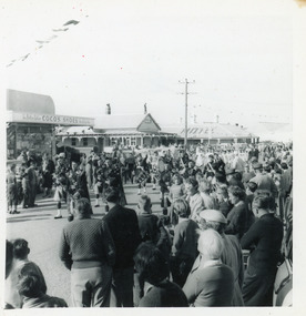 Lakes Entrance Historical Society
Photograph, Fish, Marie, 1961c
Black and white photograph of the crowd on Esplanade, watching the street procession during the visit of the Governor General Lord and Lady Dunrossil. In the background Coco's Shoe Shop and Victoria House Motel. Lakes Entrance Victoriatownship, celebrations, retail trade, motels -
 Charlton Golden Grains Museum Inc
Photograph, Charlton Shire, Shops, east end of High St, Charlton c. 1987, c.1987
Newsagency established c. 1912 by Dudley & Morse. Sold to F Jones in early 1940's. Royal Cafe built for Travaglia's c. 1912Colour photograph showing a row of shops. Cars are parked in front of the shops and there are three trees. An orange school crossing sign is next to dark blue car. Person in pale blue on LH side of photo. There are a variety of signs displayed along the front of the shop verandahs. From left to right; The Sun, THE AGE, Bendigo Advertiser , FUN PARLOR, (both partially obscured by a tree), FRUIT & VEGETABLES, 7 DAYS WEEKLY, FISH & CHIPS, CHICKENS B.B.Q. Building at the end of the shops is a Butchery and has a large sign for FEEDLOT STEAKS on the side wall.dudley, morse, f jones, royal cafe, travaglia, charlton, business -
 Charlton Golden Grains Museum Inc
Photograph, Charlton Shire, Lou's Cafe High St Charlton c.1987, c.1987
Lou's Cafe c. 1987. In the 1930s and early 40's it was Riches Cafe and Billiards Saloon. Sold to Halligan's, Duggans, Jerry Cowell until 1951 when Luths took over the building as a Car and Tractor agency. Next door was Bennett's Shoe Repair Shop which was later a Stock & Station Agency. Part of a streetscape series done for the Shire of Charlton c. 1987.Colour photograph of a single storey building. Signage on the windows reads Lou's CAFE and on the awning Lou's MILK Bar. Other signs on the windows read Fresh Fruit VEGS, meals, TAKE AWAY FOOD, FISH & CHIPS, HAMBURGERS. Signs above the awning advertise Pauls Streets and Peters ice creams. Two cars parked in front of shop and a man and a woman are standing beside one of the cars. Drive way to the left of the cafe and a single storey, glass fronted building is on the LH side of the photo. Signs on the windows read Crafts, Haberdashery, Gifts and BAGGAGE. To the right of the cafe is a yellow-green fence.lou's cafe, riches cafe and billiard saloon, halligan, duggan, jerry cowell, business -
City of Kingston
Photograph - Colour, Circa 1993
Edithvale is a suburb in the City of Kingston. It is located between Aspendale and Chelsea on the Port Phillip Bay and built within remnant areas of the Carrum Carrum swamp. The foreshore precinct comprises a wide sandy beach, with low sand dunes and numerous historic boat sheds. The suburb consists of older style dwellings and former holiday houses, combined with mid-century housing and newer homes. The large blocks are increasingly subdivided and the existing dwellings demolished to accommodate units and townhouses, thus changing the landscape of the area and reducing the tree canopy.The beachside suburb of Edithvale was previously part of the extensive Carrum Carrum Swamp. The area was once a source of fish and eels for the Mayone-Bulluk clan of the Bunurong people. Over time the area was drained and predominantly devoted to dairy farming and holiday houses. The farms were gradually sold and subdivided with a large number of homes built after World War II and in the 1960s. Edithvale is mainly residential with a shopping strip along Nepean Highway but little significant industry was ever established in the area apart from a plaster works and confectionary factory, both now closed.Aerial colour photograph of Edithvale as viewed from Alexandra Avenue in the north to Ella Grove Chelsea/Edithvale in the south. The area is built-up with residential housing and facilities including Edithvale Primary School, numerous churches and the Edithvale Railway station. Large sections depict the remnant Carrum Carrum swamp. Edithvale Common and the former "Duck Inn" (Melbourne Water/Friends of Edithvale Seaford Wetlands) can be seen. Edithvale Recreational reserve, the velodrome and Edithvale Public Golf Course are prominent. The image shows vacant land in the area now known as Aspendale Gardens and the newer residential section of Chelsea Heights is not developed. A bike path has been established to cover the secondary drain. The Golf Links Court residential development located off Hughes Avenue is a large vacant block.Yellow circular adhesive sticker on plastic Black ink (marker): * (asterisk) Black type on white adhesive sticker: P000108edithvale, aspendale, chelsea, carrum carrum swamp -
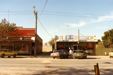
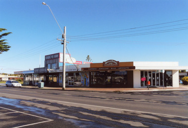
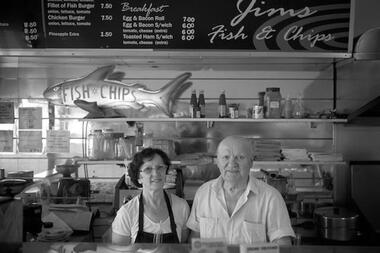 Darebin Art Collection
Photograph, David Wadelton, Jim & Pam in their High Street Fish & Chip Shop, 2014
... Jim & Pam in their High Street Fish & Chip Shop...Jims Fish and Chips Jim & Pam in their High Street Fish ...jims fish and chips -
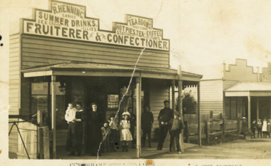 Lakes Entrance Historical Society
Postcard - Hennings Tea Room, S Vogt Bairnsdale, 1910 c
on back of card Fish 32 Francis St Bairnsdale Hennings were early Lakes Entrance familySepia toned postcard showing R Hennings Tea Rooms on Esplanade Cunninghame Group of ten adults and children outside shop with group of children outside next shop Lakes Entrance VictoriaCunninghame Gippsland Lakesbusinesses, genealogy, people -
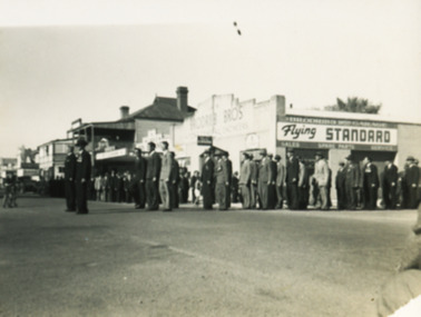 Lakes Entrance Historical Society
Photograph - Bairnsdale March, M O Fish, 1948 c
Many men in photograph are wearing service medals. Brodribbs Garage in background and Searls Dry Cleaners next to itBlack and white photograph of a march being assembled on corner of Main and Service Streets. A long line extends along footpath in front of shops and across Main Street Bairnsdale Victoriacommunity, people, events -
 Lakes Entrance Historical Society
Photograph - Esplanade Lakes entrance, Holding M, Shops, 1997
Colour photograph showing Chinese takeaway, Lakes printing, Surf Shack, Fish O Fare, Wells Fargo retail stores on the corner of Carpenter Street and the Esplanade. This was the site of Harbeck store. Lakes Entrance Victoria.retail trade, construction, historic sites -
 Ithacan Historical Society
Photograph, C. Raftopulos - Seafood & Oyster Business, Early 20th century
... bars and fish shops. raftopoulos NSW oyster company A faded ...The seafood and oyster business was owned by a C. Raftopulos, possibly located in NSW. Many Greeks who migrated to Australia from Ithaca during the first half of the twentieth century either established or worked in family owned businesses mostly involved with the food industry, including oyster bars and fish shops. A faded sepia photograph mounted on cardboard. Four men are standing outside the shop, a seafood and oyster business. The signage suggests the oysters were supplied by the New South Wales Oyster Company. The number 195 is above the door. raftopoulos, nsw oyster company -
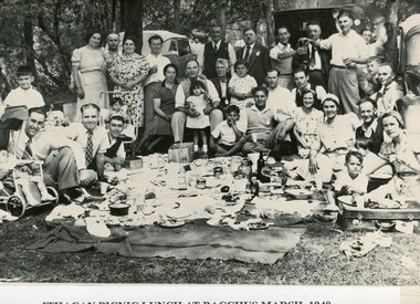 Ithacan Historical Society
Photograph, Ithcan Picnic, c 1940s
... of the families ran family businesses such as fruit shops, fish shops ...From its earliest days, the Ithacan Philanthropic Society has conducted an annual family picnic held at country towns on Melbourne's urban fringe. For many years Bacchus Marsh was a popular venue where this picnic group was photographed. Women would prepare delicious traditional Greek food and families would group together to enjoy a wonderful picnic spread. The annual Ithacan Picnic has been a very important event on the society's social calendar. In the early days, as many of the families ran family businesses such as fruit shops, fish shops and cafes, Sunday was the only break they had away from their work. The picnic gave them a chance to relax and to catch up with extended family and friends. Today the picnic continues to be an extremely popular day for the members where generations of Australian Ithacans get the opportunity to reunite. A black and white photograph of a large group at a picnic standing and sitting around and enjoying a picnic meal which has been spread out on the ground. Three cars are parked in the background under the trees. -
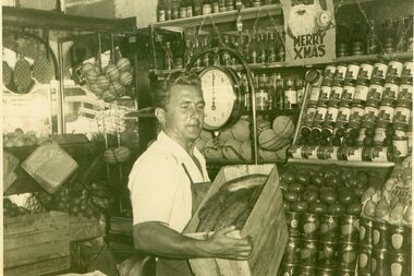 Ithacan Historical Society
Photograph, Speros Defteros, fruiterer, c 1950s
Speros Defteros is the fruiterer in the photograph. He arrived in Melbourne in 1938 to join his father in a Coburg fruit shop. During his working life he had fruit shops in Toorak Road in South Yarra, Centre Road in Bentleigh and Domain Road in South Yarra. He later supplied fruit to restaurants and hotels in Melbourne. As a result of racial prejudice he experienced on his arrival, Spero took up boxing and later wrestling where he experienced success and was nominated to compete for Greece in the London Olympics of 1948. As he was unnaturalised at the time of the Melbourne Olympics he competed once again for Greece in 1956. Spero is an example of many young Ithacans who left Greece between the war years to join relations in Melbourne and to work in a family business. They later went on to open their own business, mostly in food retailing businesses such as fruit, fish and chips, milk bars and restaurants. A black and white photograph of a man holding a box of cucumbers in his fruit shop. -
 Melbourne Tram Museum
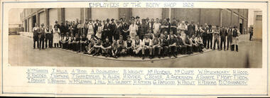
Photograph, "Employees of the Body Shop 1928", 1928
This photograph shows 51 men standing and 25 men sitting on a bench or kneeling, wearing a variety of clothes. There are some men "lurking" in the background. Photo taken with a fish-eye lens. See also item 8647 for a similar photo using a fish-eye lens. In the background is W2 class tram No. 546, nearing completion in the background. This tram entered service late Dec. 1928. Named employees: W McGibbon, J Mills, A Todd, A Doubleday, Mr Pender, Mr Cluff, W Stuchberry, H Hood, R Rhodes, J Watkins, J Shakespear, W Allen, H Ryder, C Boxer, A Anderson, A Sharpe, F Moat, F Hook, I Porrat, S Braham, W McLennan, I Hill, W C Gilbert, H Ritson, G Hapgood, W Prout, H Perkins, D O'Shannesy.Yields some information about the Preston Workshops body shop tram car builders in 1928.Photograph mounted onto a white card with names and title hand written in.tramways, preston workshops, staff photo, body shop, tram 546 -
 Melbourne Tram Museum
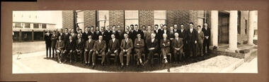
Photograph - Preston Workshops Engineering Staff, 1928
This photograph depicts 41 men dressed in suits and ties, positioned in front of the Office or the Engineering office at Preston Workshops. It is likely that these individuals are engineers, draftsmen, clerks, and managers. The image was captured using a fish-eye lens, which creates a rounded effect. Item 8648 of the body shop employees also taken with a fish-eye lens is dated 1928. Photo taken before the extension of the building for the laboratory in 1940 towards Cameron Hall. For more details on the extension, refer to item 6932. Yields some information about the engineering staff at Preston Workshops, possibly 1928.Photograph mounted onto a brown card.tramways, preston workshops, staff photo, engineers