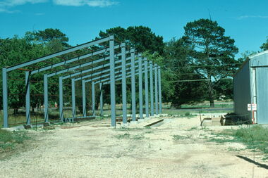
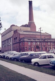
Showing 174 items
matching garden structures
-
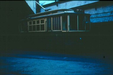 Ballarat Tramway Museum
Slide - 35mm slide/s, c1955
Agfachrome Professional plastic mount (blue base, white cover) reproduction slide of a colour slide of a Geelong tram just outside the depot building structure - poor photograph. Tram in SEC livery, possibly photographed just before closure. tramways, trams, geelong, depot -
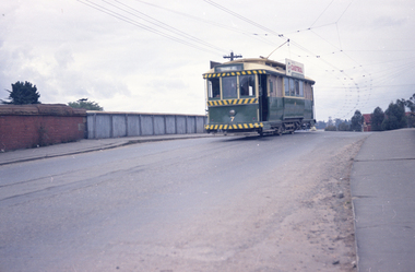 Ballarat Tramway Museum
Negative, Travis Jeffrey, 5/08/1962 12:00:00 AM
Colour Negative No. N406, of the Bendigo No. 7, showing Quarry Hill, crossing over the railway bridge, in Mitchell St with the railway bridge structure in the background. Tram has a Castrol Oil roof advertisement. Photo taken possibly on 5/8/1962. Colour laser printed copy of image stored in box 73. Original negative hires scan and image updated 28/5/2020.In red pen on folder that contained negative, "NR96B" and "5 Aug 62". trams, tramways, bendigo, railway station, mitchell st, tram 7 -
 Ballarat Tramway Museum
Book, Dipl-Ing Gunter Claus and Krupp Stahl AG, "Structures of Permanent Way for Rail Bound Traffic", 1981
Book - Foolscap size, approx. 100 pages, duplicated and bound into grey card folders, stapled and binding tape on the left hand side, titled "Structures of Permanent Way for Rail Bound Traffic", published by Krupp - Stahl AG 1981. Published by the University of Alberta, Edmonton, Alberta Canada. Written by Dipl-Ing Gunter Claus, shop manager, Krupp Stahl AG Switch department. Has an index, many drawings, photographs, types of track structures, rails, turnouts, points, geometry.trams, tramways, trackwork, points, tramways, rails -
 Ballarat Tramway Museum
Document - Photocopy, Bill Kingsley et al, "COTMA Its Origins, Aims and Operation", 1990's
Photocopy of a paper titled "COTMA Its Origins, Aims and Operation", by Keith Kings, Executive Officer, presented to the Meeting of the Historical Engineering Relics Committee of the Institute of Engineers Annual Conference, 7 April 1978. Looks at the structure of COTMA, preservation movement in Australia, and formation of COTMA and past conference and that all work is voluntary.trams, tramways, cotma -
 Bendigo Historical Society Inc.
Photograph - HILDA HILL COLLECTION: BLACK AND WHITE PHOTOS, 1919-1924
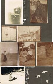
Series of Black and White Photos Post War Life for Hill Family & Friends. Total 8 Photos. Kath 'The Ranche' Eppalock September 1919. Kath dressed in 20's ? Dark dress, fur stole around neck, cloche hat, corrugated iron fence with wooden rail on top, garden setting. Arch, wearing white shirt waistcoat and dark trousers, gable roofed house in background, brick chimney left, tree at corner of house roof, Monte Video Queensland July 1924. Four ladies all wearing dark skirts and white blouses, all wearing broad rimmed hats, windmill tank on stand in background, tall post and wire netting, structure to the right, Kilmore October 1919. A Swan on the reservoir unknown place January 1920. lady wearing dark skirt and white blouse and hat, holding ball in left hand, right hand maybe swinging a tennis racquet ( not visible), post and rail fence in the far background. Lady sitting on stool wearing a dark skirt and white blouse, high post and wire netting fence, dark coloured horse to left, post and rail fence far right background, holding a camera bag and camera on stool beside her. Flirt the Dog, standing in doorway, door is broken and leaning to the right, shed has wide timber planks for cladding, 'The Ranche' Eppalock November 1919. Helen Mount Buffalo Tobogganing, wearing dark skirt, jacket with striped sleeves, and hat, August 1924.Hilda Hill Personal Collectionaustralia, history, post war life -
 Bendigo Historical Society Inc.
Photograph - HILDA HILL COLLECTION: BLACK AND WHITE PHOTOS, 1917-1924
Series of Black & White Photos Total 6 Hill Family & Friends During the First World War and after. Rita, wearing a dark dress with white collar and holding a dark coloured hat, background is large brick structure with windows to right and small section of veranda, pal tree, Railway Reserve Kyneton 1918. Man and two women wearing white dresses and dark hats, man wears dark suit white shirt and dark tie with his back against a large wheel, white sheet on ground between them and indistinguishable articles on sheet, Hibernian Picnic Axedale November 13th 1918. Group of young girls and boys all dressed in light coloured clothing gathering Botanical gardens January 1917, Miss N. Linnane reclining on cane lounge chair on verandah, weatherboard wall of house, verandah post, rock garden edging in foreground, May 1918. Monte Video Property Queensland Jeff, dressed in dark trousers and white shirt, holding a skinned rabbit, water tank in background, wire fence, July 1924. Father & Mother, Father wears a grey suit with white shirt and dark tie, Mother seated is wearing a dark dress with striped collar and white blouse, 'The Ranche' Mollison Street Eppalock.Hilda Hill Personal Collectionaustralia, history, post war life -
 Bendigo Historical Society Inc.
Photograph - HILDA HILL COLLECTION: BLACK AND WHITE PHOTOS, 1918-1923
Series of Black & White Photos of Hill Family and Friends during the war and post war life. Total 8 Photos. Welcome Parade General Pa n Bendigo October 21, 1918, tram wiring post in street, large two storey building in the background named Stanley's Coffee palace at corner of Mitchell and Mollison streets, Large crowd on roadway, Covered wagon among crowd with Good Shepherd laundry written on the side, foreground shows General Pau being driven through the crowd, General Pan is wearing a Napoleon style hat. Doreen dressed in a light coloured dress with white collar standing before a hedge, at rear is part of a corrugated iron roof gable, S.H.L.C. 27 September 1918. Group of four ladies three dressed in white and other a darker colour all seated on the ground, distant background a row of trees along a fence line, tea time Hibernian picnic Axedale 13 November 1918. Three women and young boy all seated on the ground, the ladies are all in white and two wearing white hats, young boy is dressed in suit with white shirt and dark tie and his right hand is pointing to his open mouth, to their right is a wooden structure and distant background more people can be seen, dinner time Hibernian picnic Axedale 13 November 1918. Overdeveloped photo of two young men standing between two shrubs and in front of a full length external window blind, 'The Ranche' February 1918. Group of four males dressed in dark coats and grey trouser at the snow Mt. Buffalo July 1923. Baby Irene clothed in white with bonnet seated in an English style pram with large wheels, picket fence and shrubbery in background, may 1918. Gert dressed in white shirt dark cardigan and dark skirt standing in front of hedged garden and trees, a small part of a roof can be seen between the trees, Railway Reserve 1918.Hilda Hill Personal Collectionaustralia, history, post war life -
 Bayside Gallery - Bayside City Council Art & Heritage Collection
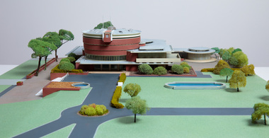
Model, Alan W. Chandler, Brighton Municipal Complex, 1959
This model of the Brighton Municipal Offices was made by Alan W. Chandler. The Brighton Municipal Offices were designed by Kevin Knight of Oakley and Parkes with the engineers John Connell and Associates and were erected by Prentice Builders Pty Ltd. The foundation stone was laid on 13 February 1959 and the building was opened on 21 July 1961. The interior decoration and furniture was by Grant Featherston. As is common practice, an architectural model was prepared to present the final concept of the building for approval to the Brighton City Council. In February 1959 festivities occurred to celebrate the centenary of the municipality of Brighton. A garden party attended by two hundred Brighton residents was held in the grounds of the Brighton Town Hall. This model graced the centre of the lily pond during the event. The following day the foundation stone of the Brighton Municipal Offices was laid.Architectural model of a large public building in orange brick, the main cylindrical tower is set within a rectangular structure, with circular and oval roof structures. The model is set within landscaped grounds with paths, a water feature, several trees and bushes, lawns and flower beds.brighton municipal complex, brighton civic centre, brighton chambers, architectural model, model, alan w. chandler, kevin knight, oakley and parkes, architecture, municipal offices, municipal building, scale model -
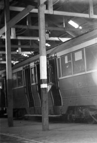 Ballarat Tramway Museum
Negative, Wal Jack, mid to late 1950's
Yields information about the tram 41 in the depot.Negative and Digital image of the Wal Jack Ballarat Negative file of No. No. 42 in the depot. Shows the depot structure.trams, tramways, depot, tram 42 -
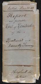 Ballarat Tramway Museum
Document - Report, Henry Smith, "Report on probably cost of construction of the Ballarat and Dunolly Tramway", 23/6/1857
Report - 9 pages- handwritten, dated June 23 1857 to the Provincial Committee of the Ballarat and Dunolly Railway" Prepared by Henry Smith Civil Engineer, looks as various aspects of a prolapsed timber rail / sleepered tramway plated, horse drawn, grades, earthworks. Gives a total cost of 2897 pounds. Last page has a ink and washed sketch of the track structure - plan and cross section. Only the cover, first page and last page imaged.trams, tramways, tramways, costs, dunolly, timber tramways -
 Ballarat Tramway Museum
Negative, Wal Jack, early 1950's
Yields information about tram services in Sturt St and the building structures.Negative and Digital images of the Wal Jack Ballarat Negative file of tram 39 in Sturt St at Dawson St. Tram has the destination of Mt Pleasant. In the background is the Golden City Hotel and the Harry Davies store.trams, tramways, drummond st nth, tram 39 -
 Ballarat Tramway Museum
Negative, Wal Jack, early 1950's
Yields information about tram services in Sturt St and Grenville St and the building structures.Negative and Digital images of the Wal Jack Ballarat Negative file of tram 39 entering Bridge St, crossing Grenville St after leaving Sturt St. In the background is the Bucks Head Hotel. a Jeweller and Handbags Novelties shop. Note the Forest City signal on the pole and a letter (receiving pillar) box.trams, tramways, bridge st, grenville st, sturt st, signals, forest city signals, tram 39 -
 Ballarat Tramway Museum
Photograph - Digital image Set of 3, Warren Doubleday, 13/01/1979 12:00:00 AM
Set of 3 digital images of the construction of the shed extensions to the BTPS depot on 13/1/1979. .1 - showing the structure at the time the steelwork contractor went under or bankrupt and the pits. .2 - the 4 road inspection pit. .3 - as for .1trams, tramways, btps, depot, buildings -
 Bendigo Historical Society Inc.
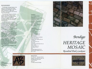
Pamphlet - MERLE HALL COLLECTION: ROSALIND PARK CREATIVE VILLAGE BENDIGO PROJECT PAMPHLET, 1995
Merle Hall Collection: Rosalind Park Creative Village Bendigo Project Pamphlet for Rosalind Park Lookout - two copies. One side of the pamphlet has a layout image of the five sections of the mosaic and the poppet head base. The sections are numbers 1 to 5 Section 1: A stylised representation of the main Bendigo Goldfield based on a geological plan (Publish in 1992). It shows the lines of reef, including the famous Hustlers, Garden Gully and New Chum. Section 2: A typical cross section of the Bendigo Goldfields Section 3: The mine layout shown in this design features part of the Garden Gully line of reef. Section 4: Shown here is the Iron Bark mine on the Sheepshead reef. It has an interesting pattern of drives, stopes and winzes. Section 5: In this section the artist uses gold as her inspiration. The larger mosaic shows quartz veins winding through the earth containing gold in its various forms. The smaller mosaic represents the atomic structure of gold. It shows the the nucleus, the six shells of the atom, their electrons and orbits. The other side of the pamphlet describes the background of the community arts project, the artist, and volunteer workers, also notes mentioning the Bendigo community history. It also lists the donors for funding and business's that supported the project, with special thanks to Eric Wilkinson - Geolpogical advoser, the students and staff from Camp Hill, St Killians and Violet Street primary schools. BRIT and La Trobe University, bendigo. -
 Bendigo Historical Society Inc.
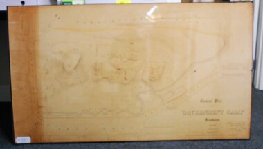
Map - CONTOUR PLAN OF THE GOVERNMENT CAMP SANDHURST 1854, 1994
Contour map (copy) of the Government Camp Sandhurst, 1854. Map is mounted on coreflute and laminated. Written in bottom righthand corner 'Contour Plan of the Government Camp, Sandhurst. Dec 1854. Signed by Richard Larritt, Assistant Surveyor, 11th December 1854.' Shown on map: Pall Mall, Bendigo Creek, Commissioner's Gully, View Place (now View Street), Post Office, Bank of Victoria, District Surgeon, Sandhurst Fire Brigade, Police Hospital, Flagstaff, Gold Office, License Shed, Military Barracks, Stables, Commissioner's Buildings, Police Office. Old Cemetery, Garden. Reference on righthand side: 'Stone or brick buildings are tinted in crimson. Wooden buildings tinted in Indian Ink. Tents and other temporary structures tinted in Burnt Sienna.' Scale of Chains, on bottom of map. Sticker on bottom left hand corner and back of map ' Presented by Survey and Mapping, Victoria, 7th Octber, 1994'.map, bendigo, government camp, pall mall, bendigo creek, commissioner's gully, view place (now view street), post office, bank of victoria, district surgeon, sandhurst fire brigade, police hospital, flagstaff, gold office, license shed, military barracks, stables, commissioner's buildings, police office. old cemetery, garden. , survey and mapping victoria. sandhurst, bendigo. -
 Ballarat Tramway Museum
Photograph - Colour slides - Geelong A Power Station, 1960's and April 1971
1 - Colour slide of the former Geelong A Power Station on the corner of Yarra St and Corio Tce (now Brougham St). First portion on the corner built by the Electric Lighting and Traction Co of Australia. The Geelong tram depot, operated by the Melbourne Electric Supply Co was incorporated within the structure during 1912. Operated by the State Electricity Commission from 1930 until the 1960's. Photo taken prior to the demolition of the chimney during the late 1960's. 2 - Colour slide dated April 1971, taken after the chimney has been demolished. Yields information about the former Geelong A power station prior to its partial demolition and incorporation into a shopping centre. Portions of the original brick buildings have been retained.1 - Green plastic Fuji Film Plastic slide of Photograph of Geelong A Power Station from Yarra St. 2 - Kodachrome cardboard colour slide, date stamped April 1971. No details of Photographer recorded on slide other than the date stamp.geelong, geelong a, power station, mesco, secv, tramways -
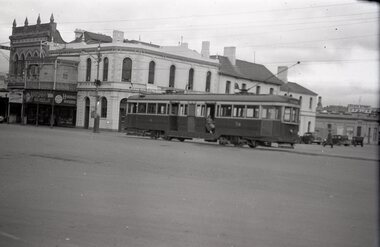
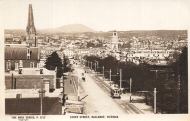 Ballarat Tramway Museum
Postcard - Sturt Street Ballarat, Victoria, Rose Stereograph Co, 1920s?
Photo taken from the City Fire Brigade station at the corner of Sturt and Raglan Streets, looking east towards Mount Warrenheip. Has an eastbound ESCo tram. Photo shows the overhead structures, Harry Davies & Co. Drapers Importers, Ballarat Town Hall and the general view of the city. On the rear is a large Rose symbol and publisher details.Yields information about Sturt St during 1920sPostcard - Rose Series P 1717, Sturt Street looking east. Second copy - cigarette card size - 63mm x 87mmHas an address in Macarthur St, Ballarat on rear. Second copy has in ink "To Ken from Paul Kiwi4755"ballarat, sturt st, fire watch tower, harry davies -
 Kew Historical Society Inc
Plan - Subdivision Plan, H C Crouch, Old Golf Links Estate, 1930s
The land in North Kew between the Outer Circle Railway and the River Yarra was released in sections. This release included 80 lots. Most of this area was released during the Depression years in the early 1930s.Subdivision plans are historically important documents used as evidence of the growth of suburbs in Australia. They frequently provide information about when the land was sold on which a built structure was subsequently constructed as well as evidence relating to surveyors and real estate and financial agents. The numerous subdivision plans in the Kew Historical Society's collection represent working documents, ranging from the initial sketches made in planning a subdivision to printed plans on which auctioneers or agents listed the prices for which individual lots were sold. In a number of cases, the reverse of a subdivision plan in the collection includes a photograph of a house that was also for sale by the agent. These photographs provide significant heritage information relating house design and decoration, fencing and household gardens.One part of a massive subdivision of the Old Golf Links Estate in North Kew of 80 allotments bordering Sutherland Avenue, Ramsay Avenue, Belford Road, Beresford Street and Coleman Avenue. Inset on the plan at the top left, the route of the Outer Circle Railway is clearly marked. The Kew Golf Links is identified in its current location. The land on which Greenacres Golf Club was to be constructed is at this time marked as ‘Recreation Ground’. The ‘new bridge’ over the Yarra at Burke Road is also marked on the inset map. The Plan identifies the surveyor (sic) H.C. Crouch BCE MVIS, 443 Little Collins St., Melbourne. The date of the subdivision auction sale in identified as Saturday September 25th at three o'clock.Annotations: "E" top left. "Golf Links" top right. Lots 73-76 ticked and listed as "6" poundssubdivisions -- kew (vic.), old golf links estate -
 Kew Historical Society Inc
Photograph - Cosy Five Roomed Rough Cast Bungalow, Kew, J E Barnes, c.1920
Subdivision plans are historically important documents used as evidence of the growth of suburbs in Australia. They frequently provide information about when the land was sold on which a built structure was subsequently constructed as well as evidence relating to surveyors and real estate and financial agents. The numerous subdivision plans in the Kew Historical Society's collection represent working documents, ranging from the initial sketches made in planning a subdivision to printed plans on which auctioneers or agents listed the prices for which individual lots were sold. In a number of cases, the reverse of a subdivision plan in the collection includes a photograph of a house that was also for sale by the agent. These photographs provide significant heritage information relating house design and decoration, fencing and household gardens. The photograph is also aesthetically significant as it was taken by J. E. Barnes, a nationally significant photographer. He was the most important photographer to have worked in Kew. He was active as a photographer in the district from c.1906 until his death in 1921. Best known as 'the Embarkation Photographer' (see the Australian War Memorial collection), Josiah Earl Barnes was also the official photographer employed by the Borough (and later Town, then City) of Kew. He clearly also completed commercial jobs for local businesses, as is the case in this photograph of a house for a local real estate and financial agent. A modest weatherboard house with rough-cast rendered walls. The gabled entrance incorporates elements of the Japanese aesthetic. The strong lines of the dark timber gable are reinforced by the colour and shape of the pickets in the fence. In contrast to an earlier period, the chimneys appear truncated. The use of extensive double-hung sash windows in the front rooms reflects a new interest in light in houses. The use of separate sunshades over windows in an earlier period is here replaced by an extension of the roofline over the window. The photographer Josiah Barnes died in 1921; so, the photograph of the house must predate this date. The location of the house, which was advertised for sale, has to date not been identified. Illegible inscription. Photographer's information on mount.josiah earl barnes, j e barnes, photography - kew, interwar housing - victoria, 1920s housing - kew -
 Kew Historical Society Inc
Photograph - 2 Young Street, Kew, Paramount Photos, 1920s
Subdivision plans are historically important documents used as evidence of the growth of suburbs in Australia. They frequently provide information about when the land was sold on which a built structure was subsequently constructed as well as evidence relating to surveyors and real estate and financial agents. The numerous subdivision plans in the Kew Historical Society's collection represent working documents, ranging from the initial sketches made in planning a subdivision to printed plans on which auctioneers or agents listed the prices for which individual lots were sold. In a number of cases, the reverse of a subdivision plan in the collection includes a photograph of a house that was also for sale by the agent. These photographs provide significant heritage information relating house design and decoration, fencing and household gardens.A prepossessing, large home constructed in the Arts and Crafts style. Located on the banks of the Yarra at 2 Young Street, Kew overlooking the factories of Richmond, the design of the house takes account of the gradient with the addition of a level below the front entrance. The elegant roof includes a number of projecting gables and dormers. The gables are typically half-timbered and rendered. In addition to the asymmetrically placed portico, there are at least two open verandas, supported by timber pillars and with roofs that reflect the overall pitch of the roof of the housereal estate photographs, 2 young street - kew -
 Kew Historical Society Inc
Photograph - 29 Uvadale Grove, Kew, 1920
The numerous subdivision plans in the Kew Historical Society's collection represent working documents, ranging from the initial sketches made in planning a subdivision to printed plans on which auctioneers or agents listed the prices for which individual lots were sold. In a number of cases, the reverse of a subdivision plan in the collection includes a photograph of a house that was also for sale by the agent. Subdivision plans are historically important documents used as evidence of the growth of suburbs in Australia. They frequently provide information about when the land was sold on which a built structure was subsequently constructed as well as evidence relating to surveyors and real estate and financial agents. These photographs provide significant heritage information relating house design and decoration, fencing and household gardens.When 29 Uvadale Grove, Kew was offered for sale it was described as: ‘Kew. Fine locality, 3 minutes Cotham Road. Splendidly built 6 roomed Brick Villa. Rooms 17 x 14, 16 x 13, &c. Beautifully fitted throughout. Land 70 x 134 to ROW.’ The price was advertised as being £1,400. The house exhibits key features of Federation architecture such as the gabled roof with a facing of half-timber and stucco. The veranda has a curved corrugated iron roof supported by timber pillars and fretwork. The slate roof with terra cotta ridging and finials marks a transition to the more common use of Marseilles tiles in Federation architecture.subdivisions - kew (vic.), 29 uvadale grove - kew (vic.) -
 Kew Historical Society Inc
Photograph - 'Mount Eri', 9 Highbury Grove, 1919
Subdivision plans are historically important documents used as evidence of the growth of suburbs in Australia. They frequently provide information about when the land was sold on which a built structure was subsequently constructed as well as evidence relating to surveyors and real estate and financial agents. The numerous subdivision plans in the Kew Historical Society's collection represent working documents, ranging from the initial sketches made in planning a subdivision to printed plans on which auctioneers or agents listed the prices for which individual lots were sold. In a number of cases, the reverse of a subdivision plan in the collection includes a photograph of a house that was also for sale by the agent. These photographs provide significant heritage information relating house design and decoration, fencing and household gardens.A photograph of Mount Eri, 9 Highbury Grove, an 11-room house for sale near the junction of Cotham and Glenferrie Roads. The substantial red brick, slate-roofed house and its location are not identified in the photograph, although the extent of the house is noted. It was described then as ‘well situated’ and close to 3 trams. Mathers, a financial agent in Cotham Road, placed advertisements about the sale of the property in The Argus in May and June 1919. The advertisement additionally refers to a billiard room and asserts that the house has every modern convenience. An annotation on the plan indicates that the house, with tennis court, was sold for £1960. Following extensive research, the house has now been conclusively identified, albeit extended and rendered. The house was originally built in the 19th century as a school and for much of the 20th century was used as a venue for receptions. -
 Kew Historical Society Inc
Photograph - Victorian Villa, High Street, c.1922
Subdivision plans are historically important documents used as evidence of the growth of suburbs in Australia. They frequently provide information about when the land was sold on which a built structure was subsequently constructed as well as evidence relating to surveyors and real estate and financial agents. The numerous subdivision plans in the Kew Historical Society's collection represent working documents, ranging from the initial sketches made in planning a subdivision to printed plans on which auctioneers or agents listed the prices for which individual lots were sold. In a number of cases, the reverse of a subdivision plan in the collection includes a photograph of a house that was also for sale by the agent. These photographs provide significant heritage information relating house design and decoration, fencing and household gardens.An old inscription on this photograph identifies it as ‘an elegant timber villa in High Street. It occupied part of Lot 91, bought by Edward Glyn in the land sale of 16th October 1851, and run as a flower farm’. The subdivision called the ‘Flower Farm Estate’ in East Kew occurred in 1922. [The subdivision plan is on the reverse of this photo.] The Estate included 61 lots on either side of Boorool Road between High Street and Harp Road. In the MMBW Detail Plan 2017 of 1926, a number of these new villas had already been built. Matching houses with MMBW maps can always be a challenge, however if this house was near the corner of Boorool Road and High Street, it seems to fit the profile of a house called ‘Maxton’ (demolished).Photographer's name on photograph, lower right, and stamp on mount lower right: "A. Aberline, Glenferrie".houses - maxton - high street - kew (vic.), violet farm estate, subdivisions - kew (vic.) -
 Kew Historical Society Inc
Photograph - 8 roomed DF Brick Villa, Kew, J E Barnes, c.1920
Subdivision plans are historically important documents used as evidence of the growth of suburbs in Australia. They frequently provide information about when the land was sold on which a built structure was subsequently constructed as well as evidence relating to surveyors and real estate and financial agents. The numerous subdivision plans in the Kew Historical Society's collection represent working documents, ranging from the initial sketches made in planning a subdivision to printed plans on which auctioneers or agents listed the prices for which individual lots were sold. In a number of cases, the reverse of a subdivision plan in the collection includes a photograph of a house that was also for sale by the agent. These photographs provide significant heritage information relating house design and decoration, fencing and household gardens. The photograph is of additional aesthetic significance as it was photographed by J. E. Barnes. Josiah Earl Barnes is a nationally significant photographer. He was also the most important photographer to have worked in Kew. He was active as a photographer in the district from c.1906 until his death in 1921. Best known as 'the Embarkation Photographer' (see the Australian War Memorial collection), J. Earl Barnes was also the official photographer employed by the Borough (and later Town, then City) of Kew. He clearly also completed commercial jobs for local businesses, as is the case in this photograph of a house for a local real estate and financial agent.A photograph, mounted on board of a double fronted Federation-era brick villa in Kew, photographed for a local real estate agent and financier by J. E. Barnes of Kew. On the reverse of the photograph is a subdivision plan for the Normanby Estate, East Kew - 2016.0039.1. As can be seen from the image, there is a large tear on the surface of the photograph.The brown card on which the photograph is mounted includes the following handwritten description, which may aid the identification of the house: "Kew, 3 minutes from tram, 8 roomed DF Brick Villa, tile roof including two attics, sleepout, bathroom, heater, E Light, Entrance Hall, double doors, leadlights, laundry, garden, lawns, land 75 x 170, 1975 pounds". Also photographers inscription on mount, lower left: J. E. Barnes / Photo / Phone 1966 Haw. KEW.j. e. barnes, josiah earl barnes, j. earl banes - photographer, architecture - federation style, houses - kew, real estate photographs -
 Kew Historical Society Inc
Photograph - W.B. Villa, Kew, c.1919
The photograph offers significant information relating to late Victorian / Federation colour schemes and fencing.The block fronted villa has a corrugated iron roof and a flat projecting verandah, ornamented with a trellis design of timber. The front window features a timber shade, mounted on brackets. The treatment of the block-fronted panels shows that there is an attempt to highlight imitation quoining through use of a darker colour. The windows and door are also in this darker shade. The front fence and gate are made of wooden pickets. It is unlikely that the photograph was taken at the time of the villa's construction given the size of the shrub/tree in the front garden.Subdivision plans are historically important documents used as evidence of the growth of suburbs in Australia. They frequently provide information about when the land was sold on which a built structure was subsequently constructed as well as evidence relating to surveyors and real estate and financial agents. The numerous subdivision plans in the Kew Historical Society's collection represent working documents, ranging from the initial sketches made in planning a subdivision to printed plans on which auctioneers or agents listed the prices for which individual lots were sold. In a number of cases, the reverse of a subdivision plan in the collection includes a photograph of a house that was also for sale by the agent. These photographs provide significant heritage information relating house design and decoration, fencing and household gardens.A real estate photograph, mounted on brown card, showing a double fronted weatherboard villa, located in Kew, Victoria. On the reverse of the photograph is a subdivision plan for the Altyre Estate.Stamped on mount: Top - "KEW. Close tram. Fine View. / W.B. Villa Containing 8 Rooms. / Up-to-date Conveniences. EL Etc." Below - "Land 40 x 165. 615 pounds. Sold"houses - kew, real estate photographs -
 Kew Historical Society Inc
Plan, Studley Heights Estate, 1936
Pru Sanderson, in her groundbreaking ‘City of Kew Urban Conservation Study : Volume 2 - Development History’ (1988), summarised the periods of urban development and subdivisions of land in Kew. The periods that she identified included 1845-1880, 1880-1893, 1893-1921, 1921-1933, 1933-1943, and Post-War Development. These periods were selected as they represented periods of rapid growth or decline in urban development. An obvious starting point for Sanderson’s groupings involved population growth and the associated economic cycles. These cycles also highlighted urban expansion onto land that was predominantly rural, although in other cases it represented the decline and breakup of large estates. A number of the plans in the Kew Historical Society’s collection can also be found in other collections, such as those of the State Library of Victoria and the Boroondara Library Service. A number are however unique to the collection.Subdivision plans are historically important documents used as evidence of the growth of suburbs in Australia. They frequently provide information about when the land was sold on which a built structure was subsequently constructed as well as evidence relating to surveyors and real estate and financial agents. The numerous subdivision plans in the Kew Historical Society's collection represent working documents, ranging from the initial sketches made in planning a subdivision to printed plans on which auctioneers or agents listed the prices for which individual lots were sold. In a number of cases, the reverse of a subdivision plan in the collection includes a photograph of a house that was also for sale by the agent. These photographs provide significant heritage information relating house design and decoration, fencing and household gardens.The ‘Studley Heights Estate’ on the South Side of Studley Park Road was launched in 1936. The seventeen allotments in the subdivision fronted Hyton Crescent and Studley Park Road.subdivision plans - kew, studley heights estate -
![Monnington [Estate], 1935](/media/collectors/550653872162f11fb04854aa/items/5907eb86d0ce0c14e82385c8/item-media/5907ecafd0ce0c14e823e87f/item-fit-380x285.jpg) Kew Historical Society Inc
Kew Historical Society IncPlan - Subdivision Plan, Monnington [Estate], 1935, 1935
Pru Sanderson, in her groundbreaking ‘City of Kew Urban Conservation Study : Volume 2 - Development History’ (1988), summarised the periods of urban development and subdivisions of land in Kew. The periods that she identified included 1845-1880, 1880-1893, 1893-1921, 1921-1933, 1933-1943, and Post-War Development. These periods were selected as they represented periods of rapid growth or decline in urban development. An obvious starting point for Sanderson’s groupings involved population growth and the associated economic cycles. These cycles also highlighted urban expansion onto land that was predominantly rural, although in other cases it represented the decline and breakup of large estates. A number of the plans in the Kew Historical Society’s collection can also be found in other collections, such as those of the State Library of Victoria and the Boroondara Library Service. A number are however unique to the collection.Subdivision plans are historically important documents used as evidence of the growth of suburbs in Australia. They frequently provide information about when the land was sold on which a built structure was subsequently constructed as well as evidence relating to surveyors and real estate and financial agents. The numerous subdivision plans in the Kew Historical Society's collection represent working documents, ranging from the initial sketches made in planning a subdivision to printed plans on which auctioneers or agents listed the prices for which individual lots were sold. In a number of cases, the reverse of a subdivision plan in the collection includes a photograph of a house that was also for sale by the agent. These photographs provide significant heritage information relating house design and decoration, fencing and household gardens.The first subdivision of Monnington took place in 1935. At that time, Monnington and 10 new allotments were offered for sale bordering Adeney and Marshall Avenues. In this subdivision plan, Monnington is one of 13 lots for sale. The subdivision created the irregular land holding of Monnington today. The excision of southwest corner of Monninton was caused by the need to have regular allotments facing the curve in Marshall Avenue.monnington - adeney avenue -- kew (vic.), subdivision plans -- kew (vic.) -
 Kew Historical Society Inc
Plan - Subdivision Plan, Wimba Estate, Kew, c.1925-c.1929, ca. 1925-ca. 1929
Pru Sanderson, in her groundbreaking ‘City of Kew Urban Conservation Study : Volume 2 - Development History’ (1988), summarised the periods of urban development and subdivisions of land in Kew. The periods that she identified included 1845-1880, 1880-1893, 1893-1921, 1921-1933, 1933-1943, and Post-War Development. These periods were selected as they represented periods of rapid growth or decline in urban development. An obvious starting point for Sanderson’s groupings involved population growth and the associated economic cycles. These cycles also highlighted urban expansion onto land that was predominantly rural, although in other cases it represented the decline and breakup of large estates. A number of the plans in the Kew Historical Society’s collection can also be found in other collections, such as those of the State Library of Victoria and the Boroondara Library Service. A number are however unique to the collection.Subdivision plans are historically important documents used as evidence of the growth of suburbs in Australia. They frequently provide information about when the land was sold on which a built structure was subsequently constructed as well as evidence relating to surveyors and real estate and financial agents. The numerous subdivision plans in the Kew Historical Society's collection represent working documents, ranging from the initial sketches made in planning a subdivision to printed plans on which auctioneers or agents listed the prices for which individual lots were sold. In a number of cases, the reverse of a subdivision plan in the collection includes a photograph of a house that was also for sale by the agent. These photographs provide significant heritage information relating house design and decoration, fencing and household gardens.In 1925, the City of Kew called for tenders for the construction of Wimba Avenue, Cadow Street and Lalla Street. Subsequent advertisements for the sale of land in Wimba Avenue continued from 1926 to 1929. The 18 lots (and a further five allotments on the eastern side of the street) offered for sale were unofficially described in the subdivision plan as the ‘Wimba Estate’. These lots began in Park Hill Road and extended almost to Cotham Road. The subdivision took its name from the house ‘Wimba’ in Cotham Road, which may have formed the southern boundary of the subdivision. (Wimba, at 235 Cotham Road was constructed between 1862-70). The Plan highlights the proximity and advantage of ‘electric’ trams in Cotham and Glenferrie Roads, and the Kew and Glenferrie Railway Stations. An oddity in the Plan is the reference to the electric tram terminus at Burke Road, given that the tramline had already been extended to Mont Albert in 1916.wimba estate, subdivision plans - kew, parkhill road – kew (vic.), normanby road – kew (vic.), wimba avenue – kew (vic.) -
 Kew Historical Society Inc
Plan, F R Simms & Son, Land for Private Sale: Cnr Victor Avenue and Mont Victor Road, Kew, 1950-1960
George Rimington established The Parkhill Nursery in 1877. By 1910, it was more commonly known as Rimington’s Nurseries and well known for its sale of violets. After World War II, Rimington’s Nurseries were gradually subdivided and sold. The 38 allotments were released in sections, including lots 34 to 36 on the corner of Mont Victor Road and Victor Avenue. Previous lots in the subdivision had bordered Burke Road, Rimington Avenue, Heather Grove, and Stoke Avenue. The selling point as it had been in comparable estates for a century were the proximity to transport, schools and churches, as well as the high location and excellent views. The subdivision plan shows most of the lots in the entire subdivision: 1-11, 13-26, and 34-38. Presumably, lot 12 and lots 27-33 were still to be released.Subdivision plans are historically important documents used as evidence of the growth of suburbs in Australia. They frequently provide information about when the land was sold on which a built structure was subsequently constructed as well as evidence relating to surveyors and real estate and financial agents. The numerous subdivision plans in the Kew Historical Society's collection represent working documents, ranging from the initial sketches made in planning a subdivision to printed plans on which auctioneers or agents listed the prices for which individual lots were sold. In a number of cases, the reverse of a subdivision plan in the collection includes a photograph of a house that was also for sale by the agent. These photographs provide significant heritage information relating house design and decoration, fencing and household gardens.Subdivision plan advertising five superb home sites among lots in Burke Road, Stoke Avenue, Victor Avenue, Mont Victor Road and Heather Grove.subdivision plans - kew, rimington avenue -- kew (vic.), heather grove -- kew (vic), stoke avenue -- kew (vic.), burke road -- kew (vic.), mont victor road -- kew (vic.) -
 Kew Historical Society Inc
Plan - Subdivision Plan, Six Big Home Sites, Camberwell North, c.1936
Subdivision plans are historically important documents used as evidence of the growth of suburbs in Australia. They frequently provide information about when the land was sold on which a built structure was subsequently constructed as well as evidence relating to surveyors and real estate and financial agents. The numerous subdivision plans in the Kew Historical Society's collection represent working documents, ranging from the initial sketches made in planning a subdivision to printed plans on which auctioneers or agents listed the prices for which individual lots were sold. In a number of cases, the reverse of a subdivision plan in the collection includes a photograph of a house that was also for sale by the agent. These photographs provide significant heritage information relating house design and decoration, fencing and household gardens.A subdivision in what is currently Balwyn, but which was advertised as being in Camberwell North. The subdivision included six allotments facing Buchanan Avenue and Houghton Street. The subdivision was to the east of the Pointed Firs Estate (1936). In addition to the intrinsic value of this subdivision plan, it also reveals information about the development of transport infrastructure in this area. The subdivision plan notes that the Tramways Board has approved the extension of the tram route past the current terminus at Balwyn Road.subdivision plans - camberwell