Showing 308 items
matching gold discoverer
-
 Port Fairy Historical Society Museum and Archives
Photograph
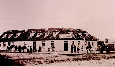
... because the labourers left town when gold was discovered... the labourers left town when gold was discovered at Ballarat in 1853 ...In 1844 a carpenter called David McLaws secured the lease on the land on the south west corner of James and Bank Streets. He later converted this to freehold by which time he had erected the Caledonian Inn. This building has been continually licensed since that time , and is believed to be the longest continual license held in Victoria. The dormer windows in the part of the building facing James street hide the fact that there is only a skeleton of rooms that were meant to be built there. They were unfinished because the labourers left town when gold was discovered at Ballarat in 1853. An advertisement for the time says “There were four parlours, a bagatelle room, eight bedrooms, a detached kitchen, stable and kitchen garden”. Well known Hotel thought to be the longest continuous licenced hotel in VictoriaBlack and white photographhotel, bank street, port fairy, james street, building -
 Bendigo Historical Society Inc.
Slide - DIGGERS & MINING. DIGGERS AND MINERS, c1800s
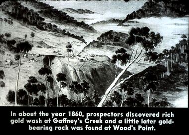
... . In about the year 1860, prospectors discovered rich gold... discovered rich gold was at Gaffney's Creek and a little later gold ...Diggers & Mining. Diggers and miners. Walhalla - Gold Town. In about the year 1860, prospectors discovered rich gold was at Gaffney's Creek and a little later gold-bearing rock was found at Wood's Point. Markings: 7 995 WAL. Used as a teaching aid.hanimounteducation, tertiary, goldfields -
 The Beechworth Burke Museum
Photograph, 1865
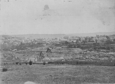
... at Spring Creek, Beechworth. Gold was discovered in this area... at Spring Creek, Beechworth. Gold was discovered in this area ...This image was taken in 1865 overlooking the diggings at Spring Creek, Beechworth. Gold was discovered in this area in 1852 and within eleven months of this discovery, over 8000 hopeful prospectors had descended on the region, transforming the seemingly undisturbed land into what a visiting journalist in 1880s referred to as; "A Titan's Field". Huge mounds of earth were churned by hundreds of miners in search for gold, almost every available resource the land had to offer was used for something; even the bark off the gums were stripped to line huts and shafts. By 1857 more than 20,000 people lived in Beechworth, and with this influx the town prospered with the building of numerous churches, banks, schools, shops and hotels along with a prison and hospital.Black and white rectangular photograph. Image is printed on matte photographic paper and is mounted on cardboard. Obverse: NO INSCRIPTION Reverse: 7771 / BEECHWORTH / FROM SPRING CREEK / 1865 spring creek, diggings, beechworth, 1865 -
 The Beechworth Burke Museum
Photograph, 1865
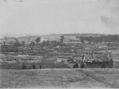
... . In February 1852 gold was discovered at Spring Creek, Beechworth.... In February 1852 gold was discovered at Spring Creek, Beechworth ...This image was taken of the diggings at Spring Creek. In February 1852 gold was discovered at Spring Creek, Beechworth. Within eleven months of this discovery, over 8000 hopeful prospectors had descended on the region, transforming the seemingly undisturbed land into what a visiting journalist in 1880s referred to as; "A Titan's Field". Huge mounds of earth were churned by hundreds of miners in search for gold, almost every available resource the land had to offer was used for something; even the bark off the gums were stripped to line huts and shafts. By 1857 more than 20,000 people lived in Beechworth, and with this influx the town prospered with the building of numerous churches, banks, schools, shops and hotels along with a prison and hospital.Black and white rectangular photograph. Image is printed on matte photographic paper and is mounted on cardboard. Obverse: NO INSCRIPTION Reverse: BMM6926 / BEECHWORTH FROM SPRING CREEK 1865 spring creek, beechworth, burke museum, 1865, gold rush -
 Bendigo Historical Society Inc.
Document - MINING IN BENDIGO COLLECTION: DISCOVERY & BENDIGO HIGH SCHOOL
... to discover gold in Bendigo. Notes describe the area of Camp Hill... to who was the first to discover gold in Bendigo. Notes describe ...Copy of typed notes referring to who was the first to discover gold in Bendigo. Notes describe the area of Camp Hill which was selected as Government Headquarters. The sole remaining relic known as the Police Barracks, a brick stable which was converted into a small hall and the old Supreme Court building. Notes include the history of the Bendigo High School. Only pages 3 & 4.document, gold, mining in bendigo, mining in bendigo, gold discovery, bendigo high school, henry frencham, governor latrobe, gold commissioner horne, captain dane, mr cockburn, mr gilbert, queen elizabeth oval, police barracks building, superintendent mcculloch, high school, teachers' college, supreme court building, town council of sandhurst, corpporate high school, st andrew's college, sandhurst grammar school, bendigo continuation school, camp hill state school, school of mines, domestic arts school, quarry hill state school, congregational church, sir alexander peacock -
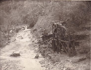 The Beechworth Burke Museum
Postcard, 1920
... and water wheel. Quartz was mined there, with gold also discovered... and water wheel. Quartz was mined there, with gold also discovered ...This postcard depicts the set-up of an abandoned gold mine. This includes a water wheel and other mining implements next to a creek. The postcard inscription indicates that this image is of the remains of the Wallaby Reef battery and water wheel. Wallaby Reef was discovered in 1864, and a prospecting claim established a four head battery and water wheel. Quartz was mined there, with gold also discovered at this location at a later date. By 1878 the mine was no longer resulting in rich deposits, this resulted in the miners moving their search for gold closer to the river where they were able to access more gold. This was in approximately 1879. In 1882 a rich deposit was found. In 1908 the battery was closed, and the mine finished. This photo was taken in 1920 and shows the deterioration of the site since its closure. Gold mining was crucial to the development of the Beechworth area. It has strong research and historical value because the clarity of the photo shows all the minute details of the mining equipment. The text on the back also indicates the mine is the Wallaby Mine, which was used for 45 years to find gold and quartz. Therefore, due to the location being quickly abandoned, this site is a rich location for historical study on gold mining during the 1900s. It can provide important information on the types of tools utilised and the impact of the mining on the environment.Black and white postcard photograph on card.8169 Be / Also near Wallaby Reef Workings / Relics of Rechabite Reef (locality) workings. / Shaft in bed of creek. Wheel used to drive sheadd (?) / stamp battery too I believe near B'worth 1920?beechworth, mining, gold mining, quartz mining, wallaby reef mine, mine battery head -
 Bendigo Historical Society Inc.
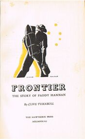
Book - ALEC H CHISHOLM COLLECTION: BOOK ''FRONTIER, THE STORY OF PADDY HANNAN'' BY CLIVE TURNBULL
... telling the story of Paddy Hannan, the discoverer of gold... of Paddy Hannan, the discoverer of gold at Kalgoorlie, West ...Book. ALEC H CHISHOLM COLLECTION. 44 page hardcover book telling the story of Paddy Hannan, the discoverer of gold at Kalgoorlie, West Australia. Published and printed about 1950 by the Hawthorn Press, Melbourne. Edition limited to 500 copies. Catalogue sticker ''2195 TUR'' on spine.Clive Turnbullbooks, collections, biography, alec h chisholm collection, clive turnbull, paddy hannan, kalgoorlie, gold -
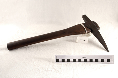 City of Moorabbin Historical Society (Operating the Box Cottage Museum)
Tool - Gold-miner's Pick, Ballarat c 1920, c1920
... Berwick, Victoria in December 2010. When Gold was discovered... in December 2010. When Gold was discovered in Victoria c1853 most ...This gold miner's pick from the Ballarat Goldfields c 1920 was donated by Mr David Hopcraft, a dealer at the Arkuna Market Berwick, Victoria in December 2010. When Gold was discovered in Victoria c1853 most of the labourers and some landowners left the market gardens and farms to try their luck on the goldfields. Local Blacksmiths made picks similar to this one for them. There was a great shortage of labour in Melbourne and at the same time, due to the huge influx of people lured by the Gold, there was an increased demand for food. The market gardeners were getting very good prices for their produce and many increased their wealth considerably and many of these tenant farmers were able to purchase their blocks of land and live a profitable life. There was such a shortage of labour that J.B.Were applied for Irish immigrants to work the farms. This pick is an example of the hand made tools many pioneers took with them when they abandoned their farms and market gardens in the District of Brighton to try their luck at prospecting when gold was discovered in Ballarat and Bendigo c1853. Some were successful , most were not and retuned again to the hard life of farming. A forged steel pick with a wooden handle. The steel pick-head was hand-forged by a blacksmith. This miner's pick was used on the Ballarat gold-fields c1920gold mining, ballarat, bendigo, early settlers, market gardeners, moorabbin, bentleigh, mining equipment, gold rush, immigrants, blacksmiths, forges, tools -
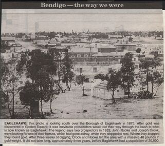 Bendigo Historical Society Inc.
Newspaper - JENNY FOLEY COLLECTION: EAGLEHAWK
... . After gold was discovered in Golden Square, it was inevitable... over the Borough of Eaglehawk in 1875. After gold ...Bendigo Advertiser "The way we were" from 1999. Eaglehawk: this photo is looking south over the Borough of Eaglehawk in 1875. After gold was discovered in Golden Square, it was inevitable prospectors would cut their way through the bush to what is now known as Eaglehawk. The legend says two prospectors in 1852, John Rooke and Joseph Crook, were looking for one of their horses, which had gone astray, when they stopped to rest. Where they stopped they found gold. After three weeks of digging, Crook and Rooke left the area with a massive 48 pounds in gold weight. It did not take long, approximately three years, before Eaglehawk had a population of 20,000.newspaper, bendigo advertiser, the way we were -
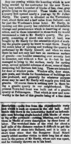 Ballarat Heritage Services
Newspaper - Newspaper article, Newsclipping Relating to Stonemason Julien Hardy
... Julien Hardy was the first discoverer of gold at Happy... Office goldfields Julien Hardy was the first discoverer of gold ...Julien Hardy was the first discoverer of gold at Happy Valley. A stonemason, he was born at Vire, Normandy, France. He established a stone quarry on the Melbourne Road, near Warrenheip (on the site now occupied by Shady Acres Caravan Park). From here, he quarried blocks that were used in the Ballarat Town Hall.Newsclippingjulien hardy, stonemason, gold, happy valley, shady acres, warrenheip, ballarat town hall -
Clunes Museum
Document
... ABOARD THE 'EMMA" IN 1851 ON JUNE 29TH 1851, HE DISCOVERED GOLD... THE 'EMMA" IN 1851 ON JUNE 29TH 1851, HE DISCOVERED GOLD IN QUARTZ ...JAMES ESMOND BORN AT ENNISCORTHY IRELAND1822., HE ARRIVED IN AUSTRALIA FEBRUARY 13TH 1840. HE WORKED FOR DONALDCAMERON ON (CLUNES RUN) AS A SHEPHERD FROM 1842 - 1846. LURED BY GOLD DISCOVERY IN CALIFORNIA, USA. ESMOND LEFT CLUNES 1849 RETURNING TO AUSTRALIA ABOARD THE 'EMMA" IN 1851 ON JUNE 29TH 1851, HE DISCOVERED GOLD IN QUARTZ AND ALLUVIUM. THE GEELONG ADVERTISER REPORTED THE DISCOVERY AND THE GREAT GOLD RUSH STARTED. JAMES ESMOND TOOK PART IN EUREKA UPRISING WITH PETER LALOR.1, PHOTO COPY OF PHOTOGRAPH OF JAMES ESMOND 1822-1890 2, SUMMARY OF THE LIFE OF JAMES ESMONDjames esmond, donald cameron, gold mining, local history -
 The Beechworth Burke Museum
Photograph, Unknown c.1900s
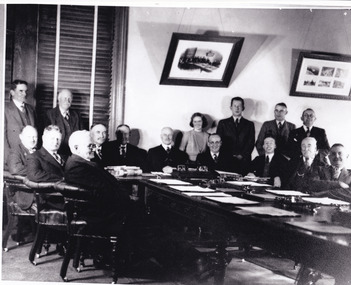
... . A History of Beechworth: Gold was discovered in the May Day Hills.... A History of Beechworth: Gold was discovered in the May Day Hills ...This image depicts a group of local counsellors from the Shire of Beechworth (est. mid to late 1900s). The identities of those within the photo remain unknown. The table and chairs featured in the image were produced in the late 19th century and have been in continual use for more than 100 years. The councellors would likely have convened in the Beechworth Town Hall. A History of Beechworth: Gold was discovered in the May Day Hills district in 1852. A canvas and timber settlement soon developed as prospectors rushed to the area. Over four million ounces of gold was recovered in the first 14 years. Between 1852 and 1857, Beechworth was a gold-producing region and centre of government, boasting many industries and a multicultural population. Beechworth was proclaimed a borough on the 11th of September 1863, a formalisation of the municipal incorporation of the town seven years before. This image is associated with the history of Beechworth; it reveals the identities of local counsellors, persons whose contribution to the Beechworth Shire could otherwise be lost to time. Black and white rectangular photograph, unmounted.beechworth council, indigo shire, local victorian government -
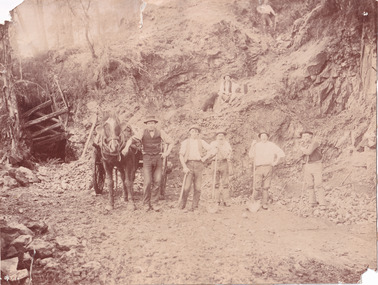 The Beechworth Burke Museum
Photograph
... state. Gold was discovered in Beechworth in February 1852... state. Gold was discovered in Beechworth in February 1852 ...This photograph depicts a reef mine in Beechworth. Reef mining, or quartz reef mining, was common in 19th Century Victoria. This gold mining technique requires mine shafts to be sunk into underground quartz reefs, with horizontal tunnels dug from the original shaft at differing levels to find the gold-bearing rock. The quartz would then be hoisted to the surface, which would then be pounded to access the gold in its metallic state. Gold was discovered in Beechworth in February 1852, at Spring Creek. Within 11 months of that discovery, over 8000 hopeful prospectors quickly descended on this region, transforming it into a thriving, wealthy township. Reef mining and hydraulic sluicing were gold mining techniques used in this region in the 19th and early 20th centuries. This photograph interestingly contains dogs alongside the miners. While dogs have been recorded as deterrents to thieves in the Victorian goldfields, these dogs appear as companions to these men.The search for gold is ingrained into the history of Victoria and therefore, images like this one can reveal important information for society and technology for the date when the photograph was taken. It also shows a location where reef mining was undertaken which provides insight into the impact on the environment at a time when it was done. Although quartz is one of the most common minerals found in the earth's crust, it does not always contain gold. Those reefs that do are rare and highly sought after by prospectors. The Beechworth Burke Museum has additional images relating to gold mining which can be analysed and studied alongside images like this one.Sepia coloured rectangular photograph printed on gloss photographic paper. Obverse: Reverse: United Shire of Beechworth/ Shire Secretary/ Reef Mining, Beechworth./ 6167.abeechworth, burke museum, gold, gold mining, gold rush, victorian gold rush, reef mining, quartz, companion dog, horse and cart -
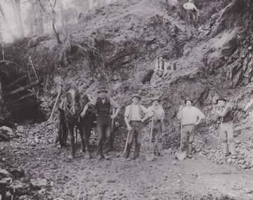 The Beechworth Burke Museum
Photograph - Photograph - Reproduction
... state. Gold was discovered in Beechworth in February 1852... state. Gold was discovered in Beechworth in February 1852 ...This reproduced photograph depicts a reef mine in Beechworth. Reef mining, or quartz reef mining, was common in 19th Century Victoria. This gold mining technique requires mine shafts to be sunk into underground quartz reefs, with horizontal tunnels dug from the original shaft at differing levels to find the gold-bearing rock. The quartz would then be hoisted to the surface, which would then be pounded to access the gold in its metallic state. Gold was discovered in Beechworth in February 1852, at Spring Creek. 8000 hopeful prospectors quickly descended on this region within the year, transforming it into a thriving, wealthy township. Reef mining and hydraulic sluicing were gold mining techniques used in this region in the 19th and early 20th centuries. This reproduction photograph interestingly contains dogs alongside the miners. While dogs have been recorded as deterrents to thieves in the Victorian goldfields, these dogs appear as companions to these men.The search for gold is ingrained into the history of Victoria and therefore, images like this one can reveal important information for society and technology for the date when the photograph was taken. It also shows a location where reef mining was undertaken which provides insight into the impact on the environment at a time when it was done. The Beechworth Burke Museum has additional images relating to gold mining which can be analysed and studied alongside images like this one.Black and white rectangular reproduction photograph on gloss photographic paper. Obverse: Reverse: L is miners 26%/ 10 x 8/ 6167.bbeechworth, burke museum, gold, gold mining, gold rush, victorian gold rush, reef mining, quartz, companion dog, horse and cart -
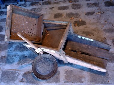 City of Moorabbin Historical Society (Operating the Box Cottage Museum)
Functional object - Gold Mining, prospector's "rocker", c1870
... Gold was discovered in Victoria c1850 and people came from... Cottage Museum) Joyce Park Jasper Road Ormond melbourne Gold ...Gold was discovered in Victoria c1850 and people came from all over the world to seek their fortune at Ballarat and Bendigo and surrounding gold fields. This large wooden rocking- box or cradle was used by gold prospectors. A handle on the rocker is pushed back and forth, as the miner put gravel into the top part and finer and heavier particles dropped through a screen, helped along by buckets of water. The bottom part of the device had slats, that caught the heavier metals. After many shovel loads of gravel were pushed through the rocker, the miner would then use his gold pan to sort out the heavy minerals to find gold. Most of the pioneer settlers in Moorabbin Shire left the area to try their luck at gold mining and there was a desperate shortage of workers to maintain the market gardens and supply food to the ever increasing population of Melbourne.This gold prospector's 'cradle' is hand made and typical of those used by many hopeful Moorabbin Shire pioneers as they abandoned their market gardens to try their luck at finding gold in the Ballarat and Bendigo minefields c1850This gold miner's rocker is very old, and very well-used. It is a large wooden rocking- box or cradle used by gold prospectors. A handle on the rocker is pushed back and forth, as gravel is put in the top part of the box so that finer and heavier particles drop through a screen.. The bottom part of the device had slats, that caught the heavier metals. i.e gold particles. The water passed through the shute at the base back into the creek or river.moorabbin, brighton, market gardens, pioneers, early settlers, fruit, vegetable, ballarat, bendigo, gold mining, gold prospedtors, gold rush, were j. b., irish immigrants, chinese immigrants, gold panning, gold digger -
 Ballarat Heritage Services
Photograph - Photograph - Colour, Clare Gervasoni, Tarilta, 2017, 16/07/2017
... . It was surveyed and named in 1864. Gold was discovered at Tarilta in 1853... River. It was surveyed and named in 1864. Gold was discovered ...Tarilta is a rural locality and former gold-mining town 12 km south of Castlemaine, 4 km north-west of Guildford and 3 km north-east of Vaughan. The last gold mining activity took place around the 1880s. It was originally Kangaroo Flat, being located where the Kangaroo Creek enters the Loddon River. It was surveyed and named in 1864. Gold was discovered at Tarilta in 1853. The Tarilta School was opened in 1860 in a Wesleyan chapel, and closed i n1925. In 1864 a township was surveyed and named Tarilta, the word being derived from an Aboriginal expression thought to mean kangaroo. In 1865 Bailliere’s Victorian gazetteer described Tarilta as being an alluvial and quartz gold-mining town with three quartz-crushing mills, three horse-puddling machines and two hotels. The elevated nature of the land around Tarilta made it accessible only by horse and dray, or on horseback. Colour photograph of Tarilta in Central Victoria. tarilta, central victoria, landcape -
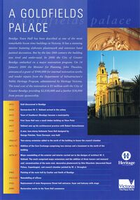 Bendigo Historical Society Inc.
Document - BENDIGO TOWN HALL ''A GOLDFIELD' PALACE'' LEAFLET, 2002
... be undertaken for the restoration. A time line beginning 1851, gold... be undertaken for the restoration. A time line beginning 1851, gold ...Bendigo Town Hall, Heritage Victoria ''A Goldfields Palace Blue Leaflet'' with coloured photographs and white text. Photographs courtesy of Westox Pty Ltd and the City of Greater Bendigo. 2002. Front page features the extensive work that would be undertaken for the restoration. A time line beginning 1851, gold discovered in Bendigo. 1854 German-born W. C. Vahland arrived in the colony. 1855 Town of Sandhurst (Bendigo) became a municipality. 1856 First Town Hall was a small timber building on View point. 1857 Vahland sets up his architectural practice with Robert Getzschmann. 1859 A new, two-storey Italianate Town hall designed by George Fletcher, Town Surveyor, was built. 1866-77 Two-storey extension added to the north of the building to house the council chamber. 1871-72 Addition of the Corn Exchange comprising two storeys and a basement to the north of the building. 1878-87 Major remodelling of the exterior and interior carried out to the designs of architect W. C. Vahland. The work comprised major extensions and the addition of three towers and mansard roof, reconstruction of the main stair, decorative plasterwork by Otto Waschatz (decorated Royal palace, Copenhagen), and council chamber painted by W. J. Straugher. 1902 Painting of the main hall by Coulter and Smith of Bendigo. 1913-15 Remodelling of offices. 1926 Replacement of main Hargreaves Street hall entrance, foyer and balcony with stage. 2000 Restoration works to the Town hall commence. The middle pages and the back show some of the conservation works that were required.bendigo, tourism, town hall restoration, 4-2000 www.heritage.vic.gov.au -
![View of the township of Golden Square / [by] Nicholas Caire, circa 1876](/media/collectors/550653872162f11fb04854aa/items/578340aed0cdd1176c6899f4/item-media/5783411dd0cdd1176c68c568/item-fit-380x285.jpg) Kew Historical Society Inc
Kew Historical Society IncPhotograph, Anglo-Australasian Photographic Company, View of the township of Golden Square, c. 1876
... . It was in this township that gold was first discovered in the district of Bendigo.’.... It was in this township that gold was first discovered in the district of Bendigo ...Nicholas Caire was born on Guernsey in the Channel Islands in 1837. He arrived in Adelaide with his parents in about 1860. In 1867, following photographic journeys in Gippsland, he opened a studio in Adelaide. From 1870 to 1876 he lived and worked in Talbot in Central Victoria. In 1876 he purchased T. F. Chuck's studios in the Royal Arcade Melbourne. In 1885, following the introduction of dry plate photography, he began a series of landscape series, which were commercially successful. As a photographer, he travelled extensively through Victoria, photographing places few of his contemporaries had previously seen. He died in 1918. Reference: Jack Cato, 'Caire, Nicholas John (1837–1918)', Australian Dictionary of Biography.An original, rare photograph from the series 'Views of Victoria: General Series' by the photographer, Nicholas Caire (1837-1918). The 60 photographs that comprise the series were issued c. 1876 and reinforced a neo-Romantic view of the Australian landscape to which a growing nationalist movement would respond. Nicholas Caire was active as a photographer in Australia from 1858 until his death in 1918. His vision of the Australian bush and pioneer life had a counterpart in the works of Henry Lawson and other nationalist poets, authors and painters.‘View of the township of Golden Square’ : Views of Victoria (General Series) No.57 : Albumen silver photograph | Photo on card with Title and Description on reverse | Mounted 24 x 30 cm; Photo 12 x 17 cm.On Reverse: ‘This Township is situated in the Bendigo district, on the road to Castlemaine, and although it is of little importance as a business town, is nevertheless of large importance in consequence of the great number of Quartz Reefs it contains. Almost every house is undermined, and large fortunes have been made by the proprietors. The Church in the distance is that of the Wesleyan body. It was in this township that gold was first discovered in the district of Bendigo.’nicholas caire (1837-1918), golden square (vic), bendigo (vic), gold mining, landscape photography - victoria -
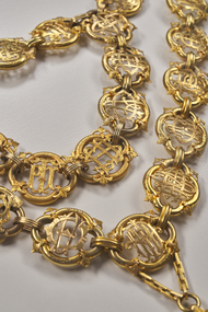 City of Greater Bendigo - Civic Collection
Ceremonial object - City of Bendigo Mayoral Chain, F Prescott Jeweller et al, 1893
... and is inscribed with the following: / Bendigo gold field discovered... and is inscribed with the following: / Bendigo gold field discovered ...The Bendigo mayoral chain or chain of office was donated by George Lansell in 1893 and manufactured from local gold by F Prescott. The design of modern mayoral chains (also known as a livery collar) mimics the ancient gold collar of Esses worn by the Lord Mayor of London which was bequeathed to his successors by Sir John Aleyn (who died in 1545) and which has a large jewelled pendant added in 1607. Source: Wikipedia https://en.wikipedia.org/wiki/Livery_collarDesigned and manufactured by Mr. E. Prescott from 9ct Yellow Gold in 1893 and believed to be made from Bendigo gold, the Bendigo mayoral chain was conceived by Mr J.H. Abbott and created with financial assistance of Mr George Lansell the "Gold King" of Bendigo who contributed the central medallion. The 18 links which made up the original chain represented serving mayors to date and were gifted by ex mayors or their representatives. The main chain consists of 35 links of quatrefoil form with the name of each mayor and the years of their term engraved and filled with black enamel. Overtime, as the chain grew too long to wear, it was separated into two joining chains eventually consisting of another 34 link section, totaling 69 links. The monogram of each mayor in gold is placed in the centre of each link and the links are connected by filigree 9ct gold joining curbs, unique to this period. The engraved central 'drop' or medallion is an eight pointed form with the body being an irregular oval containing four projections and four recesses forming the eight points. The shield section depicts the Australian emblem in miniature above and larger central Bendigo Coat of Arms filled with coloured enamel. The reverse of the medallion bears Lansell's name and is inscribed with the following: / Bendigo gold field discovered in 1851/ proclaimed municipality of Sandhurst /1855 / and city 1871/ Named changed to City of Bendigo 1891, in honor of which event / Cr J. H. Abbott, M.L.C. / inaugurated the mayoral chain / and medallion was presented to the city council / by George Lansell, Esq / to whose implicit belief in the inexhaustible / nature of our gold resources and the idefatigable energy / in developing them Bendigo mainly owns its / present prosperity / June 1893 / W. Honeybone, Town Clerk /sandhurst, bendigo, mayor, mayoral chain, george lansell, prescott, abbott, blashki, council, 1893, city of greater bendigo ceremonial item -
 Eltham District Historical Society Inc
Photograph - Digital Photograph, Marguerite Marshall, One Tree Hill Mine, Smiths Gully, 8 June 2006
... Gold was discovered on One Tree Hill in 1854. The site has...Gold was discovered on One Tree Hill in 1854. The site has ...Gold was discovered on One Tree Hill in 1854. The site has been worked intermittently until fairly recent times. Published: Nillumbik Now and Then / Marguerite Marshall 2008; photographs Alan King with Marguerite Marshall.; p53 Though still a working mine, One Tree Hill Mine at Smiths Gully, now stands in a tranquil reserve surrounded by bush and native animals - in contrast to its heyday. In the mid 19th century, when the mine was part of the Caledonia Goldfields, hundreds of men in search of their fortune worked the alluvial gold in the Yarra River, its tributaries and the reefs that made up the goldfields. Miner Stan Bone, assisted by Wilfred Haywood, is the last of the independent gold miners in the area and still uses the quartz crushing battery as miners did when gold was first discovered in the area in 1851.1 Stan, who is the last of six generations of miners in his family, was aged 17 when he began mining on his father Alex’ mine, The Golden Crown in Yarrambat. These days, after blasting the gold-bearing rock in Mystery Reef, one of the four reefs at One Tree Hill, Stan transports it around five kilometres by tip truck to the Black Cameron Mine for crushing. There he uses water from the waterlogged mine, (which still contains gold), as the Happy Valley Creek at One Tree Hill is usually dry.2 The One Tree Hill Mine has been worked for close to a century since it opened around the late 1850s.3 The Swedish Reef was its most productive reef and one of the largest in the area. Around 1859, extractions included 204 ounces (5.8kg) of gold, won from 57 pounds (26kg) of stone.4 Then during World War Two, Stan’s uncle, Bill Wallace, and Alex Bone, closed the mine. In 1973, Stan, with his Uncle Bill, reopened the Black Cameron Mine and worked there until 1988. Stan resumed mining One Tree Hill in 1998. As late as the 1920s gold was picked up by chance! When crossing a gully on his way to vote at the St Andrews Primary School, Bill Joyce picked up some quartz containing gold. This site was to become the Black Cameron Mine. The Caledonia Diggings, named after Scotland’s ancient name by local Scots, began around Market Square (now Smiths Gully) and included Queenstown (St Andrews), Kingstown (Panton Hill) and Diamond Creek. There were also poorer bearing fields in Kangaroo Ground and Swipers Gully (now Research). * None of these compared in riches to the Ballarat and Bendigo fields5, but the Caledonia Diggings continued intermittently for close to 100 years. Gold was discovered in Victoria following a bid to stem the disappearance of much needed workmen to the New South Wales diggings. Several businessmen offered a reward of £200, for the discovery of gold within 200 miles (322 km) of Melbourne. Late in June 1851, gold was first discovered at Andersons Creek, Warrandyte. Then in 1854, George Boston and two other men discovered gold at Smiths Gully. Gold transformed the quiet districts, with a constant flow of families and vehicles on the dirt tracks en route to the Caledonia Diggings. Three thousand people worked the gullies in Market Square, including about 1000 Chinese miners. The square established its own police, mining warden, gold battery, school, shops and cemetery and grog flowed. Market Square flourished until the middle 1860s. Bullocks transported quartz from the Caledonia Goldfields to the crushing machinery at the Queenstown/St Andrews Battery, near Smiths Gully Cemetery. It was destroyed by bushfire in 1962. By the late 1850s, most early alluvial fields were in decline, but minor rushes continued until around 1900 and some until the early 1940s. Some miners did well, although most earned little from their hard labour in the harsh and primitive conditions.6 But according to historian, Mick Woiwod, the gold fields helped to democratise society, as individuals from all walks of life were forced to share experiences, and the ability to succeed, depended less on inherited wealth or social rank.This collection of almost 130 photos about places and people within the Shire of Nillumbik, an urban and rural municipality in Melbourne's north, contributes to an understanding of the history of the Shire. Published in 2008 immediately prior to the Black Saturday bushfires of February 7, 2009, it documents sites that were impacted, and in some cases destroyed by the fires. It includes photographs taken especially for the publication, creating a unique time capsule representing the Shire in the early 21st century. It remains the most recent comprehenesive publication devoted to the Shire's history connecting local residents to the past. nillumbik now and then (marshall-king) collection, gold mining, one tree hill mine, smiths gully -
 The Beechworth Burke Museum
Photograph, 1857
... with gold washed out of the surrounding granite, these alluvial... with gold washed out of the surrounding granite, these alluvial ...This photograph is of old mine workings on the site of the Spring Creek diggings. Spring Creek is a contact zone for granite pluton and siltstones, shales and standstones; which has, over time, encouraged natural springs to form. Enriched with gold washed out of the surrounding granite, these alluvial deposits achieved fame from 1852 onwards as the Spring Creek Diggings sprang to life (not realised as geographically important until 1871). In Spring Creek that runs behind the main street of Beechworth, near the foot of Newtown Hill a pint pot of gold was discovered on one of these expeditions in 1852 by prospectors Baker and Strickland and the gold rush town of Spring Creek was formed. Australian gold rushes have always created a sense of independence and freedom; as do-it-yourself, off-grid, low-tech adventures. People of all backgrounds were drawn to the gold fields by the prospect of riches and adventure, but they also learned self-sufficiency and found freedom of expression. Industry boomed, new practices were adopted and social norms were upended. This image is of historical significance as it informs on the history of Australian gold mining. It represents the innovation that accompanied the mining industry and the importance of gold mining in town building and regional histories. Black and white rectangular photograph on unmounted board.gold mining, spring creek, mining, geography, geology -
 Orbost & District Historical Society
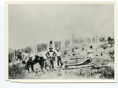
black and white photograph, late 19th century - early 20th century
... gold was discovered in the Bendoc River. This was quickly... gold was discovered in the Bendoc River. This was quickly ...This photograph shows land clearing at Bendoc. From 1845 the Bendoc area was part of pastoral leases. In the 1850s alluvial gold was discovered in the Bendoc River. This was quickly exhausted, and a number of mines began successful reef operations. At the head of the river, the settlement of Clarkville clustered round several other mines. Many miners, including numbers of Chinese, sluiced the rivers. The population of the area was as high as 500 during this period. The township was surveyed in 1869 and the hotel built in 1870. This building was burnt down in the early 1900s and rebuilt. A school was also begun at this time. In the 1870s there was a decline in gold mining. Some miners selected land, which in many cases is still held by descendants. Dairying was common in the early days, supplying a butter factory at the New South Wales border, and a milk factory at Orbost in more recent times. Wheat was grown for the settlers' own use and ground at Bombala. Now beef cattle grazing is the main occupation. (info. from Victorian Places)This is a pictorial history associated with the early settlement of Bendoc in East Gippsland.A badly distorted black / white photograph of a horse drawn wagon, three men and two women clearing land.on back - "Clearing land at Bendoc"bendoc-land-clearing bendoc-early-settlement -
 Phillip Island and District Historical Society Inc.
Photograph Album, Kodak, Phillip Island Cemetery, c 1990
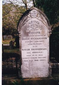
... in 1850. Sarah and Joseph were married when gold was discovered... sisters arrived in 1850. Sarah and Joseph were married when gold ...The Album was compiled by Nancy McHaffie late 1990's, with the assistance of Edith Jeffery's, with her book "Garden of Memories" and extensive knowledge of Phillip Island. The Cemetery lies back from the road and is surrounded by Manna Gums, rare Peppermint Gums, Blackwoods and other native trees. In all 25 acres of land were set aside as Crown Land in the land settlement of 1868. There are 6.2 acres of wetlands near the cemetery entrance.466-23: Joseph Richardson came to Australia in 1837 from Liverpool, England. Sarah Arbuckle and her two sisters arrived in 1850. Sarah and Joseph were married when gold was discovered in Victoria. They went to the diggings and had some success. Joseph bought land on Phillip Island when it was open to freehold selection in 1868. The family moved to Phillip Island shortly afterwards, to a house they built on a hill west of Cowes. They called their home "Everton" after a Liverpool suburb. The house still stands in Church Street, known as "Tallawalla". 466-24: The McIlwraith family came from Melton, Victoria to Heath Hill, Rhyll in 1869. They played an important part in the early history of Phillip Island. James was a foundation member of the Trust, John and Alan played their part in the local scene. John was President and Alan Secretary of the Cemetery Trust for many years.phillip island cemetery, nancy mchaffie, edith jeffery -
 Bendigo Historical Society Inc.
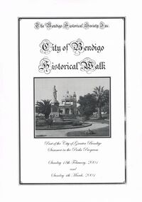
Book - CITY OF BENDIGO HISTORICAL WALK BOOK, 2001
... and another view. Important Bendigo Dates; 1851, April gold discovered... gold discovered at Golden Square by Margaret Kennedy,1851 ...Photocopy mock up of original booklet of The Bendigo Historical Society Inc. 'City of Bendigo Historical Walk' containing photographs of historic buildings to be seen on the walk. Front cover Queen Victorian Gardens, Town hall, Mechanics Institute/School Of Mines and Industry, H. M. Prison Bendigo, Camp Hill Police Barracks, Sandhurst Corporate High School, Central State School No. 1976, The Cascades, District Lands Office (Dudley House), Masonic Temple and Hall, Sandhurst Volunteer Rifle Brigade Orderly Room, Bank of Victoria, Henry Jackson's Store View Point,Alexandra Fountain, Beehive Store/Mining Exchange, Colonial Bank. Hustlers Royal Reserve NO. 2/R.S.L. Memorial Hall, Post Office 3rd 4th and final, Bendigo Law Courts, Shamrock Hotel 2nd and another view. Important Bendigo Dates; 1851, April gold discovered at Golden Square by Margaret Kennedy,1851 Approx. 200,000Troy oz. of gold found in Bendigo, 1852 475,857 Troy oz. Gold for the year, 1853 November 31st Bendigo Hospital admits first patient,1853 December 9th Bendigo Advertiser first issue printed, 1854 First Land Sales and streets are surveyed and named for the first time, 1854 Census of Bendigo showed 15,480 residents plus 4,000 Chinese, 1855 Sandhurst Municipal District formed, 1861 Sandhurst Proclaimed a Town. 1862 Railway to Melbourne opened, 1867 Visit by His Royal Highness the Duke of Edinburgh, 1871 July 21st Sandhurst proclaimed a City, 1881 Population of Sandhurst 14,577 residents, 1882 First telephone communications introduced, 1890 Electric trams (battery) commenced running, 1891 May 18th City of Sandhurst changes its name to City of Bendigo.book, bendigo, buildings, historic -
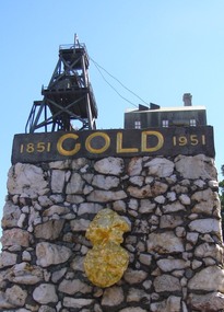 Ballarat Heritage Services
Photograph, Dorothy Wickham, Gold Monument, Ballarat, c2010
... Gold was discovered in Ballarat in 1851 when many people... Office goldfields Gold was discovered in Ballarat in 1851 when ...Gold was discovered in Ballarat in 1851 when many people rushed to the diggings. A monument commemorates the centenary of the finding of gold at Poverty Point and is dedicated to the memory of pioneer miners of Ballarat. It records gold yields, nuggets and the richest recorded yields of both alluvial and quartz mines. The replica gold nugget on the monument is the `Welcome Nugget`, found in Ballarat in 1858, weighed 2,217 ounces and was sold for £10,500. The memorial, known as the Pioneer Miners’ Monument, was made to commemorate Ballarat's gold centenary. It was proposed that part of the Pioneers' Memorial Fund might be used. This fund was started with £1300 profit from the 1938 centenary celebrations. (Age (Melbourne), The monument was created by John Edward Skilbeck, a toolmaker with Ronaldson and Tippett. John Skilbeck had a deep interest in Ballarat History, and undertook much research with Bert Strange and Keith Stacpoole. Councilllor William Ernest Roff provided the copper for the memorial from scrap copper obtained during his plumbing business. The copper was reworked by John Skilbeck, and was soldered in the kitchen of his home at 14 Frank Street. Colour photograph of the gold monument on the corner of Sturt Street and Albert Street, Ballarat. It commemorates the discovery of gold at Poverty Point in August 1851, and was The monument was unveiled in 1951 and is mainly constructed of large piecesof quartz, with a miniature popper head on the top made of copper. Mounted on the side is a replica of the Welcome Nugget, which was unearthed on the corner of Humffray and Mair Streets, Ballarat on 09 June 1858.FRONT This monument was erected by the Ballarat Historical Society to commemorate the finding of gold at Poverty Point 21st August 1851 and is dedicated to the memory of/ pioneer miners of Ballarat LEFT SIDE Richest recorded yields alluvial mines Band of Hope 303269 Ozs Prince of Wales 168929 Koh I Noor 164157 Great Redan Ex 110111 Albion 107125 Bonshaw Fr 96520 Park 94699 St George 86702 Sir Wm Don 76830 Hand in Hand 76830 Sir Henry Loch 43562 Quartz Mines Star of the East 256758 Ozs Band of Hope 158299 Victoria United 152013 N Woah Hawp 129562 New Normanby 127562 Britannia 103225 Llanberris No 1 100533 Black Hill 91665 Last Chance U 83766 Llanberris 71364 Speedwell 66000 South Star 64444 Sulieman Pasha Companies 62666 RIGHT Recorded gold yield 20606000 ozs Nuggets Alluvial Welcome 2217 ozs Saraha Snads 1619 Lady Hotham 1177 Canadian 1 1117 Canadian 2 1011 Koh 1 Noor 834 Eureka 625 Lady Loch 617 Prince of Wales 606 Bakery Hill 571 Native Youth 540 Faboulous yields of earliest diggings not offically recorded Quartz Nuggets N Woah Hawp 5-- 300 200 Ozs White Horse 500 Woah Hawp 444 266 262 Canton 257 200 Q Victoria lease 410 U Black Hill Coy 315 Tinworths 250 Parade Coy 245gold monument, ballarat, skilbeck, poppet head, j.e. skilbeck, john skilbeck -
 Clunes Museum
Photograph, TOWN OF CLUNES, 1886
... . Gold first discovered here 1st July 1851 Printed narrative... OF CLUNES - Population 4874 - Number of dwellings 1100. Gold first ...CLUNES TOWNSHIP IN 1886BLACK WOODEN FRAMED PHOTOGRAPH OF CLUNES. HAND TINTED WITH A NARRATIVE WHICH WAS GLUED ONTO THE GLASS. VIEW LOOKING SOUTH NEAR THE PRESENT DAY SCENIC ROAD LOOKOUT.TOWN OF CLUNES - Population 4874 - Number of dwellings 1100. Gold first discovered here 1st July 1851 Printed narrative: A hand-tinted photo-engraving from the Handbook of Victoria, published for the Colonial and Indian Exhibition in London, 1886. Looking south from near the present-day Scenic Road lookout, the illustration projects the image of Clunes as a goldmining town The view shows the headframes of several mine shafts, the Central Clunes Q.M.Co., and the Boundary, No.1 and No.2 shafts of the South Clunes G.M.Co. The headframe on the skyline in the middle distance was probably that of the Bute & Downes Amalgamated G.M.Co., near the railway station. colonial and indian exhibition in london 1886, bute & downes amalgamated, buildings, mining -
 Robin Boyd Foundation
Document - Script, Robin Boyd, The Flying Dogtor. Episode 18 The Visitors, 1963
... discovered a gold nugget in his bag from the mines and told nurse... discovered a gold nugget in his bag from the mines and told nurse ...The mysterious spots were caused by mosquito bites, due to the stagnant water from the flood. They had run out of medicines, bandages, everything, with no money to buy more. The Dogtor discovered a gold nugget in his bag from the mines and told nurse Sister Spaniel to take it to the bank to change it for money. Life then returned to normal at Hilltop Hospital. Then one day, a big loud silver helicopter appeared in the sky with a notice: WOOMERA RANGE. V.I.P. TOP SECRET. SPACE SURVEY. ROCKET DIVISION.The Flying Dogtor" series was broadcast on Australian Television Network (later becoming the Seven Network) between February and April 1964 (see item D254 for schedule).Typewritten, carbon copy, foolscap, 2 pagesPage 1: handwritten 'CUT' on left hand side.the flying dogtor, robin boyd, crawford productions, manuscript -
 Bendigo Historical Society Inc.
Book - Wells Family scrapbook
... W Gibbs and when gold as discovered they left their wives... W Gibbs and when gold as discovered they left their wives ...George Edwin Wells was born in Oxford in 1826. He served an apprenticeship as a coachbuilder and in 1841 he went to New Zealand. He was returning to England in 1848 when he changed his mind in Singapore and turned around and came to Melbourne. He operated a store with Mr W Gibbs and when gold as discovered they left their wives in Melbourne and went to the gold fields of Ballarat in 1851. At this time George was newly married to Catherine Kiely. In 1852 the two men were at the Golden Gully area of the Fryers Creek gold fields, they then move to Bendigo, initially to White Hills before settling in Long Gully. They then brought their patient wives, who had only had visits from their husbands, to Bendigo. George had several successful mining ventures in Bendigo. He died in 1898. One of his sons, Alfred, married Margaret Rotherham in NSW where he was living. Alfred died in 1911 leaving Margaret with a young family. She moved to Bendigo to be nearer to family support. Alfred and Margaret's daughter, Elma Winslade Wells 91904 - 19/1/1988) became a teacher and was posted to Camp Hill Primary School. She was also heavily involved in the Scout movement in the Bendigo area.Blue hardcover scrapbook belonging to the Wells family. (Elma Wells). The cover has gold, black and blue flowers and birds on it. The word "scraps" in red within a gold rectangular box completes the cover. Inside all the pages are filled with drawing and pictures of people, animals, flowers and landscapes. Also, various poems are transcribed on the pages. Newspaper cuttings are also glued to pages and in two yellow envelopes.Inside cover in pencil: The Wells Family scrap book donated to the Royal Historical Society Bendigo Branch by Miss Elma W. Wellsfamily history, wells family -
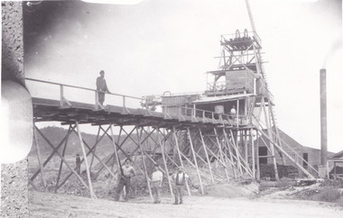
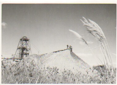 Bendigo Historical Society Inc.
Photograph - CARWARDINE COLLECTION: CENTRAL DEBORAH MINE BENDIGO, 9th April, 1953
... two remaining active mines. It's 102 years since gold... remaining active mines. It's 102 years since gold was first ...Photograph. Carwardine collection, photograph of poppet head and mullock heap. On back reads 10.2.1956, in Sun news, Thursday 9.4.1953, page 12. Central Deborah mine, one of Bendigo's two remaining active mines. It's 102 years since gold was first discovered at Golden Square, but today only two Deborah mines are working where once 3000 mines hummed. The Bendigo field had yielded 22,000,000 ounces valued at 110,000.000 pounds and three times more on today's value but last years output was only 10,000 ounces and the year before 13000 ounces. Two photos.Herald - Sunbendigo, business, carwardine soap and candle -
 Federation University Historical Collection
Plan, Burrumbeep, 1884, 16/10/1884
... was to become the Ararat Mining Division, gold was discovered in May... was to become the Ararat Mining Division, gold was discovered in May ...Auctions of Crown land were introduced in the Colony of Victoria from 1851 to encourage settlers to occupy and work the land. Many squatters purchased land at auction at the upset (minimum) price of £1 per acre. In some areas where demand was high, such as the goldfields, the price realised at auction was much more. Land was put up for sale in the study area on the Burrumbeep run in May 1855, on the Lexington run in 1857, and on the Gorrinn run in 1858. (http://www.ararat.vic.gov.au/library/document/thermatics.pdf, accessed 27 January 2015) For 70 years or more, Yalla-y-Poora, Burrumbeep, Edgarley, Mount William and Narrapumelap ranked in the leading wool producers in Victoria. 1 Stud owners at Yalla-y-Poora, Eurambeen, Burrumbeep and Challicum crossed merino sheep with sheep descended from John Macarthur's Camden Park in New South Wales. (http://www.ararat.vic.gov.au/library/document/thermatics.pdf, accessed 27 January 2015) In what was to become the Ararat Mining Division, gold was discovered in May 1854 on the Burrumbeep run at a place that became known as Pinky Point on the Mount William goldfield. By 21 June 1854, between 600 and 1,000 people had arrived. (http://www.ararat.vic.gov.au/library/document/thermatics.pdf, accessed 27 January 2015)\ Town allotment plan for Burrumbeep. Merrymbuela, Borung, Lexington and Langi Logan are neighbouring areas. The plan includes the Burrumbeep Pre-Emptive Right (Roger and Wright); licensed land holders including Stephen Young, John Carroll, William Walsh, Thomas Purcell, Martha M. Bond, Colin Johnson, John Charles Webb, Henry Withycombe, William Henry Barbridge, John Wall, Thomas Flatelly, William Jenkinson, Elisia Radford, V. Radford, Denis Byrne, George Cook. Land holders included Andrew Maloney, Richard Wingfield Harrocks, W. Sporton, Terence Lynch, F. S. Falkiner, A. Millman, H. Morris, George Upham, J. McCLure, S. Fletcher, W. Parker, Thomas Myers, William wright, W.C. Winter, C. Wordman, Oliver A. Winter This plan is associated with former Ballarat School of Mines student Richard Squire (1875-6) Gift of the Squire FamilyVerso written in pencil - Plan of Burrembeep Ararat Burrembeep Araratburrumbeep, corrinn, langi logan, merrymbuela, lexington, ararat, roger & wright, cook, rogers, upham, george upham, ross, parsans, morris, johnson, withycoombe, colin johnson, falkiner, dsporton, john carroll, donald gordon, denis bryne, maurice dooley, martha bond, william harricks, \william wingfield harricks, william l.c. harricks, michael houlihan, thomas purcell, martin ryan, michael cody, fletcher, mccaw, w. parker, j.m. clow, elisia radford, thomas radford, thomas myers, barbridge, e. wilde, j. wall, flatelly, g. wardman, w.c. winter, david ball, jenkinson, ballarat school of mines, richard squire, squire