Showing 1256 items matching "guide book"
-
 Whitehorse Historical Society Inc.
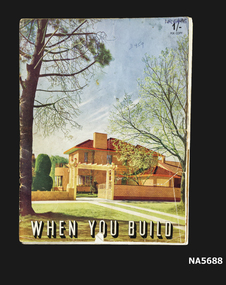
Book - When You Build, Fibrous Plaster Manufacturers' Association of Victoria, Unknown
... Paper book Guide to building a home Presented by Fibrous... Australia When You Build Paper book Guide to building a home ...Guide on Building a new home. Designs- Interior and exterior illustrations Presented with compliments of Fibrous Plaster manufacturers' Association of Victoria Paper book Guide to building a home Presented by Fibrous Plaster Manufacturers' Association of Victoria Coloured illustration of interior and exterior Methods of Home ConstructionWhen You Buildhome building, australia -
 Ballarat Tramway Museum
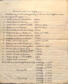
Document - cable trams, "Route Numbers and Signs"
... Handwritten notes, appears to have been copied from a guide... to have been copied from a guide or book, such as Bradshaws ...Handwritten notes, appears to have been copied from a guide or book, such as Bradshaws. Provides notes on route numbers, connecting electric trams, a round trip by cable and electric trams (9d), penny sections, through fares and details of 15 different through routes. c1918?Demonstrates copying historic information from publications.Document - 7 quarto sheets - ruled, handwritten, stapled in top left hand corner.cable trams, electric trams, melbourne, round trips, guide books, penny sections -
 Whitehorse Historical Society Inc.
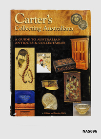
Book - Carter's Collecting Australiana
... Hard cover book A Guide for Australian Antiques... Hard cover book A Guide for Australian Antiques & Collectables ...Book has photographs of antiques with descriptions.Hard cover book A Guide for Australian Antiques & Collectables By William and Dorothy Hall Photograph by Trevor FoxA Guide for Australian Antiques & Collectablesaustralian antigues -
 Whitehorse Historical Society Inc.
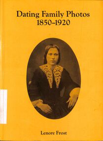
Book - Historical Reference, FROST, Lenore, Dating Family Photos 1850 - 1920, 1992
... The book guides the dating of photographs by studying its...The book guides the dating of photographs by studying its ...The book guides the dating of photographs by studying its physical properties, backgrounds used, studio name and details of fashion accents decade by decade from the 1850's to 1920'sA handbook of photograph techniques and costume descriptions by period to aid dating of photographs. It is well indexed with a good bibliography.p. 128, STAMP: Property of Nunawading Historical Society (Inc)photographs, fashions from the past -
 Orbost & District Historical Society
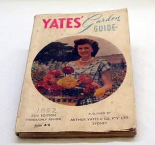
book, Yates Garden Guide, 1952
... gardening book-garden-guide Yates...In 1895 Arthur Yates wrote the first Yates Garden Guide...A soft covered book, titled "Yates' Garden Guide". "YATES... tool. gardening book-garden-guide Yates A soft covered book ...In 1895 Arthur Yates wrote the first Yates Garden Guide, a basic gardening book that is still published today. This is an early example of a book commonly used as a gardening reference tool.A soft covered book, titled "Yates' Garden Guide". "YATES' is in red print and the rest in blue. In the centre is a circular picture of a smiling woman in a V-necked check dress holding a basket of colourful flowers. Below this on the right is "1952 25th EDITION THOROUGHLY REVISED Price 4/6" . On the left are details of the publishing company.gardening book-garden-guide yates -
 Bendigo Historical Society Inc.
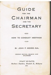
Book - MCCOLL, RANKIN AND STANISTREET COLLECTION: GUIDE FOR CHAIRMAN & SECRETARY, 1923
... Book; Brown paper covered book.' Guide for Chairman... RANKIN & STANISTREET Book; Brown paper covered book.' Guide ...Book; Brown paper covered book.' Guide for Chairman & Secretary by John Monro B.A. Printed by Wyatt & Watts Melbourne 1923. J. Stanistreet Jnr. Charing Cross Bendigo, handwritten on front cover.MCCOLL RANKIN & STANISTREETorganisation, industry, mines & mining, mccoll rankin & stanistreet -
![Book - Library Book Australian War Memorial, [The Memorial] Halstead Press, Australian War Memorial Canberra, 1955](/media/collectors/4f729f5397f83e0308601582/items/4fc232382162ef0fec3433b1/item-media/5077b2f72162ef0940a77233/item-fit-380x285.jpg) City of Moorabbin Historical Society (Operating the Box Cottage Museum)
City of Moorabbin Historical Society (Operating the Box Cottage Museum)Book - Library Book Australian War Memorial, [The Memorial] Halstead Press, Australian War Memorial Canberra, 1955
... Hardcover book. A guide to the Australian War Memorial... Edition 1953, reprinted in 1955. Hardcover book. A guide ...Hardcover book. A guide to the Australian War Memorial Canberra. The book is a blue colour with a drawing of the Australian War Memorial Canberra on the front and back covers.non-fictionwar memorial, guide, canberra -
 Clunes Museum
Document (item) - EXERCISE BOOKS, Clunes Brownie Pack, UNTITLED
... Book 1938-1941 .4 Guides/Brownie Record book 1986-1935... books 1928-1937 .3 Program Book 1938-1941 .4 Guides/Brownie ...1ST CLUNES BROWNIE PACK RECORD AND LOG BOOKS1st clunes brownie pack, record books, log books -
 Greensborough Historical Society
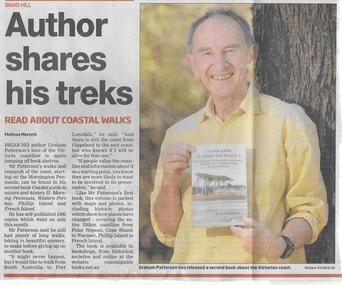
Newspaper clipping, Author shares his treks, 31/12/2014
... book "Coastal Guide to nature and history II: Mornington... discusses his latest book "Coastal Guide to nature and history II ...Briar Hill author Graham Patterson discusses his latest book "Coastal Guide to nature and history II: Mornington Peninsula, Western Port Bay, Phillip Island and French Island".Local authorNews clipping, black text, colour image.Date in pen.graham patterson, briar hill, authors -
 Falls Creek Historical Society
Booklet - Australian Ski Year Book 1981 Resort Guide
... Australian Ski Year Book 1981 Resort Guide...Australian Ski Year Book 1981 Resort Guide...The Australian Ski Year Book Resort Guide of 1981 includes... Ski Year Book 1981 Resort Guide Booklet Australian Ski Year ..."The Australian Ski Year Book" was first published in 1928 by the Kosciusko Alpine Club and the Ski Club of Australia, which with the Kiandra Ski Club, were the oldest organisations for skiing in Australia. In later years organisations from Victoria, Tasmania and New Zealand were included. It was published on behalf of N.S.W. Ski Council, Ski Club of Victoria, Ski Council of Tasmania, Ski Council of the Federated N.Z. Mountain Clubs. It aimed to provide an annual record of the sport of ski running in Australia, and of events elsewhere which would be of interest to Australian ski enthusiasts. This publication was a guide to all major resorts operation at the time in New South Wales, Victoria and Tasmania. Information about Falls Creek included a description of its location describing geographical features, its 12 ski tows and available services. The accommodation advertised included Winterhaven Lodge, Falls Creek Motel, Spargo's Lodge, Attunga Alpine Lodge, Nelse Alpine Lodge, Les Chalets, Julian Lodge and Koki and Karelia Alpine Lodges.This item is significant because it is an issue of a long-running Australian ski publication which includes items about Falls Creek, Victoria..The Australian Ski Year Book Resort Guide of 1981 includes information and advertising about resorts throughout Australia. Falls Creek information and Accommodation Guide featured on pages 10 & 11 of this issue.australian skiing, accommodation falls creek, falls creek resort -
 Ithacan Historical Society
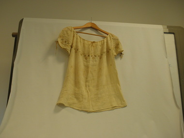
Photograph, Embroidered Blouse
... stitch embroidery book guided by fine white tapestry threads... was to copy a design from a cross stitch embroidery book guided ...The blouse was made in Greece about 1945. The method used to create this fine embroidery was to copy a design from a cross stitch embroidery book guided by fine white tapestry threads tacked onto the yolk; when the design was finished, the embroiderer would pull out each fine white tapestry thread until only the embroidery remained around the yolk of the blouse.Throughout the centuries and up until the 1970s-80s, the women of Ithaca spun, wove, embroidered and knitted. Mothers prepared their daughters' 'glory boxes' trousseau (prikia), weaving bedspreads, rag mats (koureloudes) for everyday use, finer wool rugs for formal use, as well as linen sheets, pillowcases, blankets, towels and tablecloths. Linen was also woven to make the mattress that the young brides would take to their future homes. Mothers also wove and embroidered the fabric for their daughters' underwear and petticoats, nightgowns, etc. Sewing of the garments was also done by hand. The girls embroidered handicrafts using various stitches, they crocheted lace, netted pillows and even linen carpets. The handicrafts were usually embroidered by hand in cross-stitch using linen and cotton fabric. At the time there were merchants who travelled to the villages to sell machine made goods for the trousseaus, but most of the dowries consisted of the beautifully crafted work of the women. In the 30's the SINGER Company came to Ithaca and taught the girls sewing on the machine. A handwoven silk blouse. Colour - ecru. Hand embroidered, hand sewn, very fine white tapestry was tacked round the yolk; a gusset was sewn under each short puff sleeve at the armpit; two-tone hand made silk thread cords were passed through the hollow border of the sleeves and neckline. -
 Orbost & District Historical Society
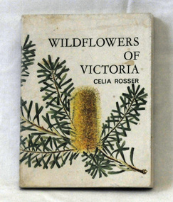
book, Wildflowers of Victoria, 1967
... . This book was the third part of the Jacaranda wildflower guides... was the third part of the Jacaranda wildflower guides series. The book ...Born Celia Elizabeth Prince in 1930, Celia Rosser began painting Australian wildflowers early in her artistic career. She first began painting Banksias after seeing a Banksia serrata near her home in Orbost, Victoria. She lived in Orbost in the 1960's( her husband had been posted to Orbost High School) where she painted and drew native flowers , in particular, banksias. Her first exhibition was at Leveson Gallery in Melbourne in 1965, and included three watercolours of Banksia species. Two years later she published Wildflowers of Victoria.Celia Elizabeth Rosser (born 1930) is a renowned Australian botanical illustrator, best known for having published The Banksias, a three-volume series of monographs containing watercolour paintings of every Banksia species. She began painting Australian wildflowers early in her artistic career. She first began painting Banksias after seeing a Banksia serrata near her home in Orbost, Victoria.A small book titled Wildflowers of Victoria and written by Celia Rosser. It was published in 1967 by Jacaranda Press. The covers are stiff card and it has an illustration of a banksia on the front cover. It has 105 pp and contains coloured illustrations. This book was the third part of the Jacaranda wildflower guides series. The book is designed to carry around in a pocket or purse.rosser-celia wildflowers banksia australian-flora -
 Linton and District Historical Society Inc
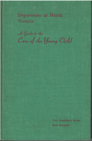
Textbook written by Dr Vera Scantlebury, A Guide to the Care of the Young Child, 1958
... as a "Guide to Infant Feeding". Book revised (with Kate Campbell... as a "Guide to Infant Feeding". Book revised (with Kate Campbell ...Vera Scantlebury Brown was born in Linton in 1889, a daughter of Dr George Scantlebury and his wife Catherine, née Baynes. Vera undertook medical training at Melbourne University between 1907 and 1913. After serving in the British Army Medical Unit during World War I, she worked in various positions in Melbourne hospitals and then studied in the US and Canada. In 1926 she was appointed Director of Infant Welfare by the recently established Victorian Department of Health, and became responsible for the development of maternal, infant and pre-school services in Victoria. In 2023 a statue of Vera Scantlebury was erected in Linton's Avenue of Honour in Denison Street. This copy of the book appears to have been owned/used by Barbara Safstrom of Linton.Textbook for nursing students and other health professionals. First compiled by Dr Vera Scantlebury Brown and published as a "Guide to Infant Feeding". Book revised (with Kate Campbell) in 1941, 1951 and 1958. Pages 346 p.: index, tables.Inscribed top right of front endpaper: 'Barbara Saftstrom / FF8269'.vera scantlebury, kate campbell, 'a guide to the care of the young child' [textbook] -
 Kiewa Valley Historical Society
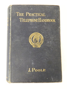
Book - Technical on Telephones / Switchboards, The Practical Telephone Handbook by J. Poole, 1912
... This book includes "Guide to the Telephone Exchange... Centre 31 Bogong High Plains Rd Mt Beauty high-country This book ...This book includes "Guide to the Telephone Exchange". As the State Electricity Commission of Victoria had a telephone exchange on the Kiewa Hydro Electric Scheme at Mt Beauty, this book is of interest. The first telephone exchange was established in the U.S.A. in 1877. In 1912 most civilised countries had one. Improvements continued as outlined in the book explaining how they work.The State Electricity Commission of Victoria constructed the Kiewa Hydro Electric Scheme and communicated using a switchboard based in Mt Beauty. This book belonged Roy F. Leibig, the grandfather of a local electrician.Black hard cover book with gold embossing of title, author and emblem "The Specialists Series" on the front cover. 630 pages with some black and white diagramsInside: "W. Kerr Newmann / 89 Moreland Grove / Coburg" written in pencil "S. Dunkerton / 8 Horne St / E. Brunswick / Oct. 7th 1913" crossed out with pencil (over handwriting with pen) "R.F. Leibig / "Orama" / Stafford St / West Preston" written in inkinstructional book; technical; telephones; switchboards; telephone exchange; state electricity commission of victoria -
 Melbourne Tram Museum
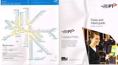
Pamphlet, Public Transport Victoria (PTV), "Fares and Travel Guide", Dec. 2012
... Pamphlet "Fares and Travel Guide" - effective Jan. 2013... Trams tramways Tickets Fares Metro Trains Guides Yarra Trams PTV ...Pamphlet "Fares and Travel Guide" - effective Jan. 2013. .Book - DL size, red coloured covers 20 pages, centre stapled, colour printed on gloss paper, has table of contents and fold out map of the tram and rail system. Givers details on travelling conditions, Myki tickets, fares and zones, touching on, refunds, Passenger information, Hours of Operation and Translated information. Has the PTV Logos. Two copies heldtrams, tramways, tickets, fares, metro trains, guides, yarra trams, ptv, tram 5013 -
 Melbourne Tram Museum
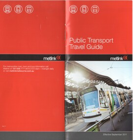
Pamphlet, Metlink, "Public Transport Travel Guide", Sep. 2011
... Pamphlet "Public Transport Travel Guide" - effective Sept...Trams tramways Tickets Fares Connex Guides Yarra Trams ...Pamphlet "Public Transport Travel Guide" - effective Sept. 2011. .Book - DL size, red coloured covers 12 pages, centre stapled, colour printed on gloss paper, has table of contents. Givers details on travelling conditions, accessibility, Authorised Officers, Customer Feedback, Public transport organisations, Passenger information, Hours of Operation and Translated information. Has photo of Yarra Trams 5013 outside Southern Cross Railway Station on front cover.trams, tramways, tickets, fares, connex, guides, yarra trams, metlink, tram 5013 -
 Mont De Lancey
Book, Arthur Mee, Arthur Mee's Children's Bible
... as a book to be read by or to a child, not as a reference book..., not as a reference book. A guide to the Contents is listed as well as a guide ...Arthur Mee wrote a type of Preface to this presentation of the bible as a book to be read by or to a child, not as a reference book. A guide to the Contents is listed as well as a guide to the Pictures included. The Old Testament and the New Testament are separated.A light green hardcover Children's Bible arranged by Arthur Mee and illustrated from the art galleries of the world, contains the Christian story interpreted for the young. There is no dust jacket. The front cover is plain with lined patterns indented around the edges. The spine has the title and the words, arranged by Arthur Mee printed in black lettering on the spine. The green tinged frontispiece shows a picture titled - Jesus Passes By, where Jesus is standing near people outside their home. The title page has full publisher details. Inside Arthur Mee has written a type of preface to this presentation of the bible as a book to be read by or to a child, not as a reference book. A guide to the Contents is listed as well as a guide to the Pictures included. The Old Testament and the New Testament are separated. There are many pictures included - some are green tinged and others are brown or sepia toned. Pp. 474. Included is a red and yellow advertising leaflet for Norwich Union Life Australia Limited, Melbourne - 'For the Best News for Anyone over 50'. There is a large coloured photograph of a family of six having a birthday afternoon tea outdoors.fictionArthur Mee wrote a type of Preface to this presentation of the bible as a book to be read by or to a child, not as a reference book. A guide to the Contents is listed as well as a guide to the Pictures included. The Old Testament and the New Testament are separated.bibles, religious books, religious fiction, children's books -
 The Beechworth Burke Museum
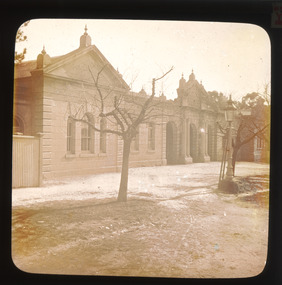
Photograph - Lantern Slide, c1900
... and heritage-focused travel guide the 'Readers Digest Book of Historic... and heritage-focused travel guide the 'Readers Digest Book of Historic ...This lantern slide shows the Ovens District Hospital (also called the Ovens Goldfields Hospital) in Beechworth in approximately 1900. The Hospital was built as part of a community push to develop the infrastructure needed for a permanent town in the 1850s. At the time there was no hospital located between Melbourne and the NSW town of Goulburn and it was recognised that the nature of mining and agricultural work predisposed people to serious injury. The community voted in 1853 to raise funds for a hospital and a voluntary committee elected from people who contributed £2 or more annually determined the organisation's management policies, which aimed to provide care for poor people at rates levied according to the person's means. Ongoing operations of the hospital were primarily supported by Government grants, however. The foundation stone was laid at a site in Church Street at a ceremony held 1st September 1856 which was attended by 2000 people using a locally crafted trowel with a tin ore handle and pure gold blade. The hospital, which was designed by J.H. Dobbyn, cost £2347. The hospital had two wards, a dispensary, apartments for a resident surgeon and the matron, an operating theatre and a board room. Further medical facilities including services to meet the cultural and health needs of the local Chinese community were later added, in addition to a Palladian-style cut-granite face built in 1862-63. It functioned as the region's primary hospital until surpassed by the Wangaratta Hospital in 1910. In the 1940s much of the building materials were salvaged and repurposed, with the exception of the facade which was restored in 1963 by the Beechworth Lions Club and still stands today. The facade featured on the covers of local history volume 'Beechworth: a Titan's Field' by Carole Woods and heritage-focused travel guide the 'Readers Digest Book of Historic Australian Towns'. Lantern slides, sometimes called 'magic lantern' slides, are glass plates on which an image has been secured for the purpose of projection. Glass slides were etched or hand-painted for this purpose from the Eighteenth Century but the process became more popular and accessible to the public with the development of photographic-emulsion slides used with a 'Magic Lantern' device in the mid-Nineteenth Century. Photographic lantern slides comprise a double-negative emulsion layer (forming a positive image) between thin glass plates that are bound together. A number of processes existed to form and bind the emulsion layer to the base plate, including the albumen, wet plate collodion, gelatine dry plate and woodburytype techniques. Lantern slides and magic lantern technologies are seen as foundational precursors to the development of modern photography and film-making techniques.This glass slide is significant because it provides insight into Beechworth's built environment and infrastructure in the early Twentieth Century, around the time of Australia's Federation. It is also an example of an early photographic and film-making technology in use in regional Victoria in the time period.Thin translucent sheet of glass with a round-edged square image printed on the front and framed in a black backing. It is held together by metal strips to secure the edges of the slide.Obverse: Y /burke museum, beechworth, lantern slide, slide, glass slide, plate, burke museum collection, photograph, monochrome, ovens district hospital, indigo shire, north-east victoria, hospital, palladian architecture, granite, community fundraising, community infrastructure, j.h. dobbyn, beechworth lions club, ovens goldfields hospital, chinese community -
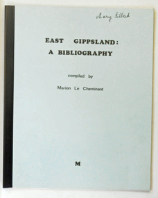 Orbost & District Historical Society
book, East Gippsland a Bibliography, June 1980
This is a useful reference tool.Two copies of a 29 pp soft covered book. The front cover is pale blue with a black plastic spine. In black text is the title "East Gippsland : A Bibliography" above "compiled by Marion Le Cheminant". At the bottom centre is "M" . This is a resource guide for bookks about East Gippsland. The cost is noted as $2.50.2289.1 - on front cover "Mary Gilbert" in black ink. 2289.2 - on front cover "M.Brunt" in black penle-cheminant-marion east-gippsland-bibliography -
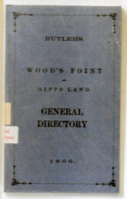 Orbost & District Historical Society
book, E-Gee Printers Pty Ltd, Butlers Wood's Point and Gippsland General Directory, 1985
This is a reprint of an original which was published in Melbourne by Butler & Brooke, Little Collins Street East. The original printer was W.H.Williams, 23 Little Bourke Street, Melbourne. On the spine was the title: Wood's Point and Gipps Land general directory, 1866.This is a copy of contemporary records of residents and businesses of Woods Point and Gippsland of 1866. It is a useful research tool.A soft covered 97pp book covered in clear plastic. The cover is blue with the title "Butlers Wood Point and Gippsland Directory" in black print with a black page border. It is a directory of residents, contemporary businesses (1866) and road guides. directory-gippsland-1866 butlers-directory -
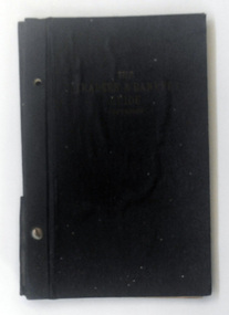 Orbost & District Historical Society
book, The Traders' & Bankers' Guide, 1929
... . The Traders' & Bankers' Guide book ...This item is a useful research tool.A black cloth covered 46 pp book containing information on how to deal with banks. It contains advertisements for banks and insurance companies. It is held together with metal screws through the spine.Inside cover - hand scribbles in red and blue penbook-finance-banking -
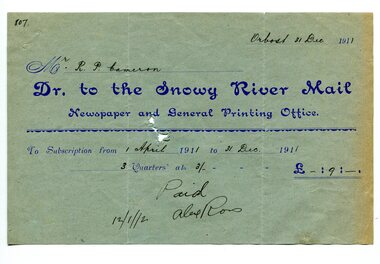 Orbost & District Historical Society
account, 12.12.1912
Previously published as The Snowy River mail and Tambo and Croajingolong gazette from 1890 to 1911. The Gippsland Courier merged with the Snowy River Mail when proprietor Lachlan Ross moved to Orbost in 1910. In 1999 the paper was acquired by the Yeates family when the Hollins family retired from the newspapers business. The paper is still being produced by the fourth generation of the Yeates family as part of East Gippsland Newspapers. They also produce the Bairnsdale Advertiser, the East Gippsland News and the Lakes Post and the yearly publications East Gippsland Visitor Guide and the Great Alpine Road Touring Guide. Robert Pullar Cameron was a Shire Councillor for many years. He married Penuel Hossack and had a family of James, Flora, Penuel and Alex.This item is an example of the early book-keeping of the Snowy River Mail newspaper and is a useful research tool.A light blue paper account with dark blue print from The Snowy River Mail, Newspaper and General Printing to R. Cameron.snowy-river-mail cameron-robert-pullar -
 Orbost & District Historical Society
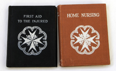
books, First Aid to the Injured ; Home Nursing, 1918-1919
These books were owned and used by sisters, Hilda and Elsa Wehner who were the daughters of Hermann Wehner, early Orbost blacksmith. Sir James Cantlie was a Scottish physician who was a pioneer of First Aid.These first aid guides produced by the St John Ambulance, the largest teacher of first aid in Australia, were an important addition to the home library and used regularly. Two small books on first aid. Both books are published by St John Ambulance Association. 1829.1 is First Aid to the Injured - a small book with a black cover. It is the 37th edition. 227pp. It was written by Colonel Sir James Cantlie. 1829.2 is Home Nursing - a small book with a brown cover. 272pp. It was written by Mildred Heather-Bigg. The title and spine printing is white on both books.1829.1 has Hilda Wehner written inside the front cover. 1829.2 has Elsa Wehner written inside the front cover. -
 Orbost & District Historical Society
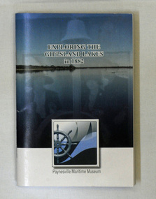
book, Exploring the Gippsland Lakes 1882, January 2010
The original book was published in Melbourne by M.L. Hutchinson, 1881. This edition was specially compiled for the Lakes Navigation Company by J. Blackwood Howie.A small book - Exploring the Gippsland Lakes 1882. this is a republication of a C 1882 book titled Tourists and Sportsman's Guide to the Gippsland Lakes and Surrounding Country. This pocket reading republishes a story from 1882 that was aimed at promoting tourism to the Gippsland Lakes. It starts with a train trip from Melbourne to Sale and then boards a steamer to experience the Gippsland Lakes. The book was published by Paynesville Maritime Museum in January 2010. It was compiled by J. Howie Blackwood.gippsland-lakes travel tourism-east-gippsland -
 Orbost & District Historical Society
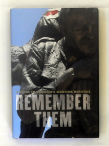
book, Remember Them, 2009
This guidebook shares the personal stories of the individuals honoured in 250 of Victoria's key war memorials. It covers metropolitan Melbourne and regional Victoria, providing a unique insight into wartime history and the local heroes who fought overseas. Garrie Hutchinson has authored and edited over 30 books, In the early 1970s Hutchinson was heavily involved in anti-war activism and alternative journalism. From the late 1970s Hutchinson moved away from writing poetry and towards a journalistic career.This is a significant research tool.A 308 pp hard cover book with a dust jacket titled Remember Them, A guide to Victoria's Wartime Heritage. The author is Garrie Hutchinson. On the front cover is a photograph of a close-up image of a sculpture of a soldier. The text is dark grey.It is arranged geographically, with accompanying maps and photographs,military-history memorials-victoria -
 Flagstaff Hill Maritime Museum and Village
Book, The New Guide to Carpentry General Framing and Joinery
... -museum shipwreck-coast flagstaff-hill-maritime-village book ...The New Guide to Carpentry General Framing and Joinery by Robert Scott ed Burn Publisher John G Murdoch flagstaff hill, warrnambool, shipwrecked-coast, flagstaff-hill, flagstaff-hill-maritime-museum, maritime-museum, shipwreck-coast, flagstaff-hill-maritime-village, book, the new guide to carpentry general framing and joinery -
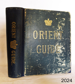 Flagstaff Hill Maritime Museum and Village
Book, Orient Guide
... Low, Marston, Searle & Rivington Orient Guide Book ...Orient Guide Editor - W J Loftie Publisher Sampson Low, Marston, Searle & Rivington flagstaff hill, warrnambool, shipwrecked-coast, flagstaff-hill, flagstaff-hill-maritime-museum, maritime-museum, shipwreck-coast, flagstaff-hill-maritime-village, book, orient guide -
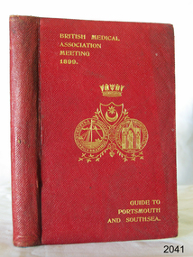 Flagstaff Hill Maritime Museum and Village
Book, Guide to Portsmouth Southsea and Neighbourhood
... to portsmouth southsea and neighbourhood book H T Lilley Guide ...Guide to Portsmouth Southsea and Neighbourhood by H T Lilley Publisher Charpentier & Co Date 1899 flagstaff hill, warrnambool, shipwrecked-coast, flagstaff-hill, flagstaff-hill-maritime-museum, maritime-museum, shipwreck-coast, flagstaff-hill-maritime-village, guide to portsmouth southsea and neighbourhood, book, h t lilley -
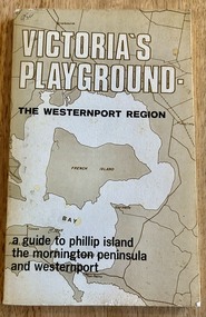 Phillip Island and District Historical Society Inc.
Book, Victoria's Playground The Westernport Region. A guide to Phillip Island, the Mornington Peninsula and Westernport, 1971
Description of Tourist Resorts on Mornington Peninsula and Westernport BayHistoricalBook - soft cover - 117 pages, First edition published 1971 by The Advisory Committee on Recreation and Tourism to The Westernport Regional Planning Authoritymornington peninsula, westernport bay, phillip island -
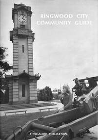 Ringwood and District Historical Society
Book, Ringwood City Community Guide (1976-77), 1976
... (1976-77) Book Book Vic Guide Publishing and Printing Company ...Ringwood Community Guide containing Council editorial, brief history of Ringwood, local Community Services and Business Listings. Also includes a street directory map of Ringwood Municipality, and a 1976-1977 Calendar."First Edition". "Front cover photograph: Memorial Clock Tower erected in 1928."rinx