Showing 463 items matching "henry parkes"
-
 Marysville & District Historical Society
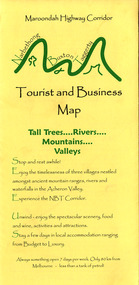
Map (Item) - Tourist and business map, Narbethong Community and Tourism Group, Narbethong Buxton Taggerty Tourist and Business Map, 04-2008
A tourist and business map of Narbethong, Buxton and Taggerty. This map was produced by the Narbethong Community and Tourism Group in April 2008. It was produced to promote the natural attractions, adventure activities and food trail from the Black Spur, through Narbethong, Buxton and Taggerty.A tourist and business map of Narbethong, Buxton and Taggerty.This publication has been produced by the Narbethong Community and Tourism/ Group (NCTG) to promote the natural attractions, adventure activities and food/ trail from the Black Spur, through Narbethong, Buxton and Taggerty./ the information provided in this publication has been supplied by the individual/ members. NCTG takes no responsibility for its accuracy./ April 2008narbethong, buxton, taggerty, victoria, australia, tourist and business map, narbethong community and tourism group, acheron valley, yarra track, wood's point, black spur, mystic mountains, the meeting of the waters, cathedral range, danico design counted cross stitch, things of sand & stone, buxton zoo nursery & oddz & enz, willowbank at taggerty, safe trek 4wd services, pnl 4wdriving, buxton trout and salmon farm, mystic mountains ski hire & outdoors, narbethong ski hire, highwood health centre, cathedral view natural therapies, narby cabinets, plants by shelian, gb timber, executive signs, rb automotive repairs, buxton car care, marysville towing & equipment hire, martyn slade building design, cathedral peak framing, black spur roadhouse & ski hire, tudor lodge roadhouse & ski hire, buxton roadhouse & persian bazzar, buxton post office general store & niche bar, igloo roadhouse, taggerty store, narby eggs, marapana agistment park, mantirri blueberry farm, carmyle farm, hazelwood hazelnuts, south cathedral lavender farm, cathedral cherries, black spur motel & caravan park, woodlands rainforest retreat, chestnut glade, black spur inn, wombat cottage, abbey lake luxury b & b spa cottages, blue views holiday cottages, camp narbethong, marapana farm stay b & b, mantirri blueberry farm b & b, little dene garden cottages, silverstream b & b cottages, nareen cabins, moondai farm b & b, south cathedral farm luxury b & b cottages, yarrolyn caravan park, sarsens rest, lomah retreat, pinjarra gardens, kingbilli country estate, henry viii manor house, buxton hotel, butters cafe of buxton, wagtail wines, little river wines, lanterns at willowbank, wirrawilla rainforest walk, wilhemina falls, the cascades -
 Marysville & District Historical Society
Map (Item) - Tourist and business map, Narbethong Community and Tourism Group, the Gateway TOURIST AND BUSINESS MAP, 08-2009
A tourist and business map of Narbethong, Buxton, and Taggerty. This map was produced by the Narbethong Community and Tourism Group Inc in August 2009. It was produced to promote the natural attractions, adventure activities, and food trail from the Black Spur, through Narbethong, Buxton, and Taggerty.A tourist and business map of Narbethong, Buxton and Taggerty.This publication has been produced by the Narbethong Community and Tourism Group Inc./ (NCTG) The information provided in this publication has been supplied by the individual/ members. NCTG takes no responsibility for its accuracy./ August 2009narbethong, buxton, taggerty, victoria, australia, tourist and business map, the gateway tourist and business map, black spur motel & caravan park, woodlands rainforest retreat, chestnut glade, black spur inn, wombat cottage, abbey lake luxury b&b spa cottages, camp narbethong, marapana farm stay b&b, mantirri b&b, little dene garden cottages, nareen cabins, silverstream b&b cottages, buxton hotel motel, south cathedral farm luxury b&b cottages, cathedral view b&b retreat, kingbilli country estate, cathedral valley farm, pinjarra gardens, willowbank at taggerty, sarsens rest, yarrolyn caravan park, danico design counted cross stitch, things of sand & stone, buxton zoo nursery, safetrek 4wd services, mystic mountains ski hire & outdoors, pnl 4wdriving, buxton trout and salmon farm, buxton bait and tackle, black spur roadhouse, tudor lodge service station roadhouse & ski hire, buxton roadhouse, buxton p.o. general store, igloo roadhouse, henry v111 manor house, buxton hotel, butters cafe, wagtail wines, little river wines, narby eggs, marapana agistment park, carmyle farm, hazelwood hazelnuts, cathedral view naturall therapies, cre8ing growth, linda hailey, naby cabinets, gb timber, narbethong timber & trading, rb automotive repairs, buxton car care, martyn slade building design, taggerty vet clinic -
 Frankston RSL Sub Branch
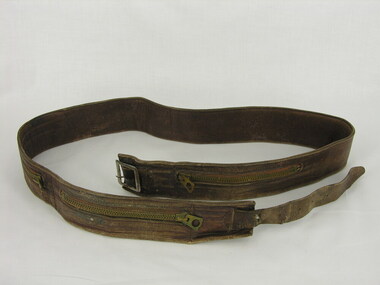
Belt, Leather Money
Frederick Henry Laurence Rankin (Laurie) VX 139086 was an Australian Army cook who served from May 1943 to June 1945 within Australia (including Darwin). he was born 24/7/1914 at Jumburra, Victoria and enlisted on 27/5/1943 at Clifton Hill, Victoria. His "Next of Kin" was Eunice Rankin. He was discharged on 4 June, 1945 and he was then posted to 2 Australian Field Artillery Regiment. He died on 27 July 1983 and buried at Fawkner Memorial Park.Leather money belt worn during World War 2 military service by Frederick Henry Laurence Rankin, service number VX139086. This belt has three zippered pockets for carrying money or other valuables. One pocket contains a ration coupon for one packet of smokes (cigarettes). world war 2, ww2, -
 Greensborough Historical Society
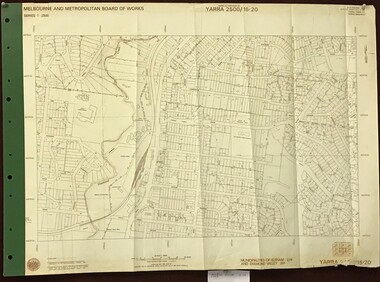
Map, Melbourne and Metropolitan Board of Works. Survey Division, MMBW, Yarra 2500 / 15.20. Eltham, 1977_08
Melbourne and Metropolitan Board of Works. Yarra 2500 [base map] 15.20. Eltham. Municipalities of Diamond Valley 257 and Eltham 238. Prominent streets include: Main Road, Henry Street and Livingstone. Features include the Eltham Station, Catholic Ladies' College, Judge Book Memorial Village and Eltham Central Park.MMBW Map in 1:2500 [scale] series. Cream parchment with green tape reinforcing on edges and punched holes on left edge.mmbw, melbourne and metropolitan board of works, shire of diamond valley, nillumbik, eltham - maps -
 Greensborough Historical Society
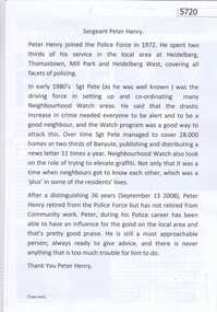
Document, with newspaper clippings, Sergeant Peter Henry, 13/09/2008
Peter Henry joined the Police Force in 1972, spending much of his service in the Heidelberg, Thomastown, and Mill Park areas. From the early 1980s, he was responsible for setting up and coordinating many Neighbourhood Watch areas. He retired in September 2008.1 p. typescript, with 7 newspaper clippings from various publicationsneighbourhood watch, peter henry, victoria police -
 Greensborough Historical Society
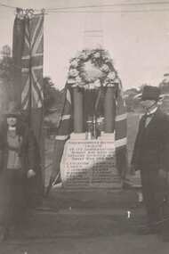
Photograph - Digital image, Fallen Soldier's Memorial Greensborough, 1923c
... Memorial Park in Henry Street Greensborough. greensborough war ...These photographs shows the World War I "Fallen Soldiers" Memorial at it's original site in Main Street Greensborough. Photographs appear to be taken early 1920s.The Memorial has been moved several times and is now situated the War Memorial Park in Henry Street Greensborough.Digital image of 2 black and white photographs.greensborough war memorial park, fallen soldiers memorial greensborough -
 Greensborough Historical Society
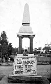
Photograph - Digital image, War Memorial Main Street Greensborough, 1923c
... and is now situated the War Memorial Park in Henry Street ...This photograph shows the World War I "Fallen Soldiers" Memorial at it's original site in Main Street Greensborough. [Thought to have been taken by Alan Partington as he is listed as taking another photo of the same Memorial in 1923]The Memorial has been moved several times and is now situated the War Memorial Park in Henry Street Greensborough.Digital copy of black and white photograph.greensborough war memorial park, fallen soldiers memorial greensborough -
 Greensborough Historical Society
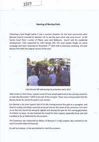
Report and photographs, Barclay Park Greensborough, 07/11/2015
On November 7, 2015 a small park in Greensborough (previously known as McKenzie Court Park, corner Plenty Lane and McKenzie Court) was renamed as Barclay Park after a local family. henry and Dorothy Barclay farmed Grace Park from 1938. Members of the family were present at the ceremony conducted by Banyule Mayor Craig Langdon assisted by Ward Councillor Mark di Pasquale. This open ground was saved from development through the work of local residents.Collection of 6 photographs and a report.barclay family, eric barclay, craig langdon, barclay park -
 Greensborough Historical Society
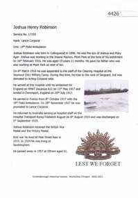
Article, Greensborough Historical Society et al, Joshua Henry Robinson, 1914-1918
A short article about Joshua Henry Robinson and his service in World War 1. At the time of his enlistment he was working at Mont ParkOne page, text and colour images.world war 1 project, joshua henry robinson -
 Greensborough Historical Society
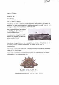
Article, Greensborough Historical Society et al, Henry Green, 1914-1918
A short article about Henry Green and his service in World War 1. At the time of his enlistment, Henry was living at Grace Park GreensboroughOne page, text and colour images.world war 1 project, henry green -
 Greensborough Historical Society
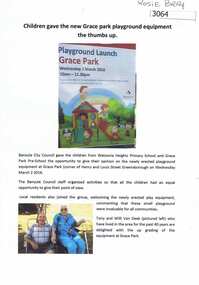
Article, Rosie Bray, Children gave the new Grace Park playground equipment the thumbs up, by Rosie Bray, 02/03/2016
... playground equipment at the Grace Park playground, corner Henry... of the newly erected playground equipment at the Grace Park playground ...Banyule Council held a launch of the newly erected playground equipment at the Grace Park playground, corner Henry and Louis Streets, on 2 March 2016. Report and photos by Rosie Bray4 p. text and colour photographs; with 8 colour photographs as printed in the documentEach photograph has identifying details written on the back, of the playground and attendees at the launch on 2 March 2016grace park -
 City of Moorabbin Historical Society (Operating the Box Cottage Museum)
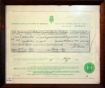
Document - Copy of Marriage Certificate William Box 1854, 14 May 1997
This copy of the Marriage Certificate of William and Elizabeth Avis-Box was obtained by CMHS member Dennis Maynard in May 1997. William Box and Elizabeth Avis Box came to Australia with his parents George and Mary Cripps-Box and siblings in 1856 William Box with his wife Elizabeth Avis Box and 13 children lived and farmed on the block of land in Jasper Road, East Brighton ( now McKinnon / Ormond) that was part of the Henry Dendy Special Survey 1841. Caroline Box, the eldest daughter of George and Mary Cripps-Box, remained in England working as a cook until she joined the family in Australia in 1863. William Box with his wife Elizabeth Avis Box and 13 children lived and farmed on the block of land in Jasper Road, East Brighton ( now McKinnon / Ormond) that was part of the Henry Dendy Special Survey 1841 Box Cottage Museum is the reconstructed pioneer cottage that William and Elizabeth lived in 1865 until they built a new house on the land. The Certified Copy of the Marriage Entry of William Box and Elizabeth Avis at the Parish Church, Tonbridge, Kent, England on November 13th 1854 in a wood frame with glass* CERTIFIED COPY OF AN ENTRY OF MARRIAGE / crest / GIVEN AT THE GENERAL REGISTER OFFICE / Application number C009059/0 / 1854 Marriage solemnised at The Parish Church of Tonbridge in the County of Kent / 206 / November 13th / 1854 / William Box 20 Bachelor Gardener / Elizabeth Avis 19 Spinster/ ………… Signed by William Box , Elizabeth Avis with Thomas Avis and Caroline Box as the Witnesses. Issued at Tonbridge 14th May 1997 MXA 171379 box william, box elizabeth avis, moorabbin, ormond, parish of tonbridge, farmers, dairy, market gardeners, pioneers, early settlers, kent, england, certificates, box caroline, avis thomas, -
 City of Moorabbin Historical Society (Operating the Box Cottage Museum)
Document - Genealogy Chart Henry Dendy (Photocopy), 19 thC
In 1840 Henry Dendy, a farmer in Surrey, England acquired a "Special Survey" from the Commissioners for Land and Emigration which gave Dendy the right to choose land in Port Phillip for the "bargain basement" price of only £1 per acre for 5120 acres, (an area of 8 square miles). The Special Survey also included the right to "the shipment of a worker for every £20 spent on land, whose free passage was paid by the Crown, equalling a total of 100 workers ". Accordingly Dendy sold his English holdings and paid the required £5120 and arrived in Melbourne in February 1841. However by this time land in the new colony was selling for £5 - £40 per acre. Because Henry Dendy possessed the order from the Colonial Office in London he was able to successfully oppose Super-intendant LaTrobe's attempts to alter the price of the land. Dendy appointed Jonathan Were, (an entrepreneur, who had arrived in 1839), as his Manager and who later became a partner. Together, Dendy and Were decided on an area 5 miles south from Melbourne, bounded by North Road, East Boundary Road, South Road and to the west by Port Phillip Bay. Were and Dendy pitched their tents in the area now known as ' Park St, Brighton' and sank a well near the corner of 'St Andrew's St and Wells St'. By 1845 J.B Were and Company had bought almost half of Dendy's land and Were built himself "Moorabbin House" in Were St Brighton made from stone, quarried from local cliffs. It was still standing in 1924. Legend records Moorabbin is named after the Aboriginal word for ' Mother's Milk ' The soil is very fertile and well supplied with water especially in the area called 'East Brighton' - now known as Bentleigh and East Bentleigh - By 1850 the area had developed with numerous market gardens, dairy farms, fruit gardens and vineyards supplying food for the growing population of Melbourne.In 1840 Henry Dendy, a farmer in Surrey, England acquired a "Special Survey" from the Commissioners for Land and Emigration which gave Dendy the right to choose land in Port Phillip for the price of only £1 per acre for 5120 acres. This land was called Brighton in the Parish of Moorabbin, County of Bourke and emigrants developed the land establishing market gardens , dairy and poultry farms that provided the food for the growing population of Melbourne. A photocopy of the Genealogy Chart of the Dendy Family that Henry Dendy brought with him when he emigrated to Melbourne 1841Genealogy signs and descriptionsdendy henry, dendy's special survey brighton 1841, governor gipps, captain lonsdale, super-intendant latrobe, port phillip, melbourne, new south wales, squatters, emmigrants, county of bourke, parish of moorabbin, early settlers, pioneers, market gardeners, dairy farmers, fruit farms, moorabbin, bentleigh, brighton, cheltenham, were jonathan binn, -
 City of Moorabbin Historical Society (Operating the Box Cottage Museum)
Document, Henry Dendy family Shield
In 1840 Henry Dendy, a farmer in Surrey, England acquired a "Special Survey" from the Commissioners for Land and Emigration which gave Dendy the right to choose land in Port Phillip for the "bargain basement" price of only £1 per acre for 5120 acres, (an area of 8 square miles). The Special Survey also included the right to "the shipment of a worker for every £20 spent on land, whose free passage was paid by the Crown, equalling a total of 100 workers ". Accordingly Dendy sold his English holdings and paid the required £5120 and arrived in Melbourne in February 1841. However by this time land in the new colony was selling for £5 - £40 per acre. Because Henry Dendy possessed the order from the Colonial Office in London he was able to successfully oppose Super-intendant LaTrobe's attempts to alter the price of the land. Dendy appointed Jonathan Were, (an entrepreneur, who had arrived in 1839), as his Manager and who later became a partner. Together, Dendy and Were decided on an area 5 miles south from Melbourne, bounded by North Road, East Boundary Road, South Road and to the west by Port Phillip Bay. Were and Dendy pitched their tents in the area now known as ' Park St, Brighton' and sank a well near the corner of 'St Andrew's St and Wells St'. By 1845 J.B Were and Company had bought almost half of Dendy's land and Were built himself "Moorabbin House" in Were St Brighton made from stone, quarried from local cliffs. It was still standing in 1924. Legend records Moorabbin is named after the Aboriginal word for ' Mother's Milk ' The soil is very fertile and well supplied with water especially in the area called 'East Brighton' - now known as Bentleigh and East Bentleigh - By 1850 the area had developed with numerous market gardens, dairy farms, fruit gardens and vineyards supplying food for the growing population of Melbourne. dendy henry, dendy's special survey brighton 1841, governor gipps, captain lonsdale, super-intendant latrobe, port phillip, melbourne, new south wales, squatters, emmigrants, county of bourke, parish of moorabbin, early settlers, pioneers, market gardeners, dairy farmers, fruit farms, moorabbin, bentleigh, brighton, cheltenham, were jonathan binn, -
 City of Moorabbin Historical Society (Operating the Box Cottage Museum)
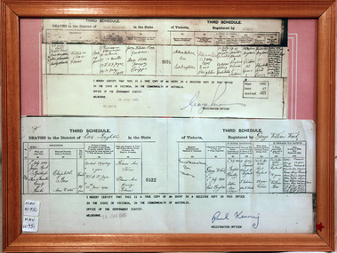
Document, Death Certificate William Box 1902, 1985
William Box1834-1902 and Elizabeth Avis Box 1835-1913 came to Australia with his parents George and Mary Cripps-Box and siblings in 1856. Caroline Box, the eldest daughter of George and Mary Cripps-Box, remained in England working as a cook until she joined the family in Australia in 1863. William Box with his wife Elizabeth Avis Box at first leased market garden allotments in Brighton that was part of the Henry Dendy Special Survey 1841. In 1868 and 1869 they purchased 2 blocks with a pioneer’s cottage in Jasper Road East Brighton ( now Ormond / McKinnon ) where they established a market garden, built a 2nd house and raised 13 children. In 1908 Elizabeth sold most of the land retaining 1 acre with the dwellings in which she resided with her two daughters until her death 1913. The original pioneer cottage was reconstructed in 1984 and is known as Box Cottage Museum William & Elizabeth Avis- Box settled in the pioneer Cottage in Jasper Road East Brighton 1868 and established a market garden whilst raising their 13 children. This Cottage was reconstructed in Joyce Park, Ormond 1984 and is the home of City of Moorabbin Historical Society. In 1960 many local residents responded to a call for the donation of historical artefacts and the Box Cottage Museum now preserves this eclectic collection for the community. A certified true copy of the Death Certificate of William Box 1834 -1902 in a wooden picture frame, obtained from The Births, Deaths and Marriages Office Melbourne Victoria 1985 THIRD SCHEDULE / DEATHS in the District of East Brighton in the State of Victoria Registered by W. Ward Certified ‘true copy of an entry in a register’……… Signed by Paul Kenny Registration Officer 1985 box william, box elizabeth, brighton, moorabbin, cottages, pioneers, ormond, colonial, mckinnon, dendy henry, museums, box alonzo, market gardeners, box cottage museum -
 City of Moorabbin Historical Society (Operating the Box Cottage Museum)
Document - Pedigree of Henry Dendy, c1840 Original ; Copy 1985
This is a copy of the document brought by Henry Dendy to the Colony in 1841. In 1840 Henry Dendy, a farmer in Surrey, England acquired a "Special Survey" from the Commissioners for Land and Emigration which gave Dendy the right to choose land in Port Phillip for the "bargain basement" price of only £1 per acre for 5120 acres, (an area of 8 square miles). The Special Survey also included the right to "the shipment of a worker for every £20 spent on land, whose free passage was paid by the Crown, equalling a total of 100 workers ". Accordingly Dendy sold his English holdings and paid the required £5120 and arrived in Melbourne in February 1841. However by this time land in the new colony was selling for £5 - £40 per acre. Because Henry Dendy possessed the order from the Colonial Office in London he was able to successfully oppose Super-intendant LaTrobe's attempts to alter the price of the land. Dendy appointed Jonathan Were, (an entrepreneur, who had arrived in 1839), as his Manager and who later became a partner. Together, Dendy and Were decided on an area 5 miles south from Melbourne, bounded by North Road, East Boundary Road, South Road and to the west by Port Phillip Bay. Were and Dendy pitched their tents in the area now known as ' Park St, Brighton' and sank a well near the corner of 'St Andrew's St and Wells St'. By 1845 J.B Were and Company had bought almost half of Dendy's land and Were built himself "Moorabbin House" in Were St Brighton made from stone, quarried from local cliffs. It was still standing in 1924. Legend records Moorabbin is named after the Aboriginal word for ' Mother's Milk ' The soil is very fertile and well supplied with water especially in the area called 'East Brighton' - now known as Bentleigh and East Bentleigh - By 1850 the area had developed with numerous market gardens, dairy farms, fruit gardens and vineyards supplying food for the growing population of Melbourne. A copy of a paper chart of the Pedigree of Henry Dendy in a wooden frame with glassPedigree / of the branch of the family / DENDY moorabbin, brighton, henry dend special survey 1841 y, early settlers, pioneers, market gardeners -
 City of Moorabbin Historical Society (Operating the Box Cottage Museum)
Document,photocopy plan 'Two Acre Village 'c1852, c1960
In the 1852 Josiah Holloway, a developer, purchased 625 acres from the squatters Richard and John King and sectioned '2 acre allotments' south of Henry Dendy's Brighton Survey along the Arthur's Seat Road ( later Nepean Highway) for sale @ £10 It became known as The Two Acre Village as settlers took up the allotments and established market gardens, general stores, butchers, blacksmiths, post office and 2 hotels. Charles Whorral opened The Cheltenham Inn and it became so popular as a meeting place that the area was called Cheltenham. The early settlers, who were predominantly English and Scottish immigrants initially leased their allotments and, because the sandy soil was so fertile, they were soon able to purchase the land and increase their acreage. Cheltenham became a very important part of the large Moorabbin Shire1871 and City of Moorabbin 1934 In the 1994 Amalgamation of Councils, when the large City of Moorabbin was divided between the newly formed Glen Eira, Kingston and Bayside Councils, the Cheltenham area was assigned to the City of Kingston A photocopy of the Plan for the 2 Acre Village in Moorabbin Parish c1852. A3 laminatedmoorabbin, brighton, cheltenham, market gardeners, pioneers, early settlers, , king. john, holloway josiah, whorral charles, arthur’s seat road, nepean highway , cheltenham inn hotel, henry dendy special survey 1841 -
 City of Moorabbin Historical Society (Operating the Box Cottage Museum)
Document, laminated List of Pioneers Moorabbin Parish, c1985
This list shows the names of the Pioneer settlers with the amount of Acres, the date purchased from The Crown and the Lot or Portion Number in the Land of the Henry Dendy Special Survey of Brighton 1841, in the County of Bourke , Victoria. The Squatters ,who arrived in the area first, used the land for grazing sheep and cattle. The Squatters had the right to graze unoccupied Crown land for ₤10 per year rental and a per capita payment for animals grazed. They could develop , improve and clear the land for the purpose of the tenancy but ownership was not permitted. When the land became useful The Crown put it on the market and the developers took over whilst the Squatters lost the improved land, dwellings and out buildings, there being no compensation paid. Squatters named John and Thomas Martin 1840-41; Richard and John King 1840- 1854 ; M.N.M.Moysey and M.J.Bickford 1841-1852 ; James McMahon 1846-1853 ; Daniel MacKinnon 1839- 1840. The 5120 Acres of the Henry Dendy Special Survey 1841were divided into approx. 83 Portions / Lots with varying acreage . Josiah Holloway, a speculator purchased 625 acres of the King Brothers run and re-sectioned the land into 2 acre Lots for Sale as market gardens. It was called The Two Acre Village later known as Cheltenham. A List of the names of The Pioneers in County of Burke Victoria c1841-1887 compiled by Lesley A. Schumer in 1985 A 3 Laminated display on wall in room 2 THE PIONEERS, Signed L.A. Schumer moorabbin, brighton, cheltenham, bentleigh, market gardeners, pioneers, early settlers, dendy henry, henry dendy's special survey 1841, squatters, king john, martin john, mcmahon james, two acre village, holloway josiah, were jonathan binn, grazing, cattle, sheep, market gardens, -
 City of Moorabbin Historical Society (Operating the Box Cottage Museum)
Document, laminated photocopy of 'Plan of Moorabbin 1850', 1853
Weston Bate, 'A history of Brighton' 1962 informs us that in 1840 Henry Dendy, who was a farmer in Sussex England, paid 5,120 pounds sterling @ 1pound per acre for a 'Special Survey of Land in Port Phillip , Australia. Henry arrived in Australia in 1841 on the frigate 'York' with his wife, son, and three servants. He also took advantage of the Government Assistance of Free Immigrants for Survey Purchasers, to help on his estate and persuaded some Sussex men with their families to follow him. However when Dendy arrived in Port Phillip he found that LaTrobe and Gipps were trying to raise the price of land close to Town to 15pounds per acre. Dendy asked merchant J.B.Were to manage his affairs and they went ahead with plans to subdivide the surveyed land called 'The Brighton Estate' This area of land extended easterly from the Port Phillip Bay to East Boundary Road and from North Road to South Road in the Parish of Bourke Victoria. The Privy Council, England , decide that Henry Dendy could purchase the land at 1pound per acre. Land Sales proceeded from 1844 as more immigrants established market gardens, farms and varied businesses in 'Moorabbin'This is a photocopy of a Map of the Moorabbin , County of Bourke c1850 showing the 'Henry Dendy Special Survey 1841'A photocopy of a Map of the Moorabbin , County of Bourke c1850. A3 size laminatedLeft corner : MOORABBIN / COUNTY OF / BOURKEdendy henry, dendy special survey 1841, brighton, moorabbin, ormond, bentleigh, market gardeners, pioneers early settlers, box william, box elizabeth -
 City of Moorabbin Historical Society (Operating the Box Cottage Museum)
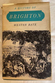
Book, Brown Prior Anderson Pty.Ltd, A History of Brighton, 1962
This book is about the history of Brighton and Henry Dendy's survey the early settlement of Brighton and its surrounds and the involvement of Dendy J.B.Were George Higinbotham Thomas Bent and J.H. Taylor in the growth of the community.xi, 425 p. : ill., maps :non-fictionThis book is about the history of Brighton and Henry Dendy's survey the early settlement of Brighton and its surrounds and the involvement of Dendy J.B.Were George Higinbotham Thomas Bent and J.H. Taylor in the growth of the community. brighton, dendy, bent, were, higinbotham, taylor, survey, settlement. -
 City of Moorabbin Historical Society (Operating the Box Cottage Museum)
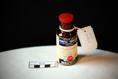
Manufactured Glass, brown bottle 'Tromax', 20thC
Potassium permanganate is an inorganic chemical compound with the chemical formula KMnO4. Formerly known as permanganate of potash or Condy's crystals, it is a strong oxidizing agent. It dissolves in water to give intensely pink or purple solutions, the evaporation of which leaves prismatic purplish-black glistening crystals. c1859 London chemist Henry Bollmann Condy had an interest in disinfectants; he found that fusing pyrolusite with sodium hydroxide (NaOH) and dissolving it in water produced a solution with disinfectant properties. He patented this solution, and marketed it as 'Condy's Fluid'. Although effective, the solution was not very stable. This was overcome by using potassium hydroxide (KOH) rather than NaOH. This was more stable, and had the advantage of easy conversion to the equally effective potassium permanganate crystals. This crystalline material was known as 'Condy's crystals' or 'Condy's powder'. Potassium permanganate was comparatively easy to manufacture.A brown glass bottle with a red plastic topped cork stopper for 'Tromax' , 'Purple Crystals' ie Permanganate of Potash , that was used as an antiseptic and disimfectant.TROMAX BRAND / PURPLE CRYSTALS/ or Permanganate of Potash / (Poisonous )/ For Household and Medicinal Uses / 2oz. / TROMAX / A PRODUCT OF/ SIGMA Co.Ltd. / MANF. CHEMISTS / MELBOURNE. Directions for Use are on back of bottlepharmacy, medicines, tromax, purple crystals, permaganate of potash, disinfectants, sigma co.ltd. melbourne, athritis, glassware, bottles, moorabbin, bentleigh, cheltenham -
 City of Moorabbin Historical Society (Operating the Box Cottage Museum)
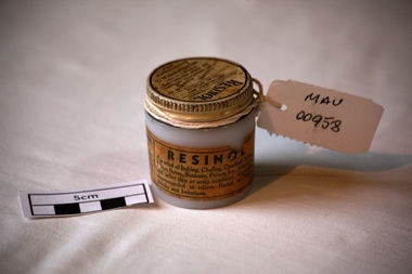
Manufactured Glass, jar 'Resinol' ointment, mid 20th C
Resinol is used to treat several different types of skin ailments. Resinol was developed by Dr. Merville Hamilton Carter (1857-1939) in his private practice as treatment for his patients in Baltimore, Maryland during the late 19th century. In 1895, Carter, along with his brother Allan L. Carter and his cousin Henry Stier Dulaney founded the Resinol Chemical Company and began to mass-produce the ointment and other medical products. After over forty years of selling Resinol, the company had John H. Buffham & Co. as an outlet in Great Britain and was a successful global distributor. Henry LeRoy Carter Sr., the son of Dr. Carter, began running the company after the deaths of his father and other staff members. The company's sales began to decline in the 1940s, and after the death of Henry LeRoy Carter Sr. in 1951, his son Henry LeRoy Carter Jr. took the place of his father and grandfather as president of the Resinol Chemical Company. At that time, the company focused more on soap manufacturing, but continued to sell Resinol. For the rest of the 20th century, Resinol's popularity continued to dwindle. It was purchased by ResiCal Inc. in 2002.A clear glass jar with a metal screw top containing 'Resinol' antipruritic and sedative ointment. Lid : ‘RESINOL’ / ( Ungt Resinol) / ANTIPURITIC AND / LOCAL SEDATIVE / A Soothing Preparation THAT PROMOTES HEALING/ OF SKIN IRRITATIONS/ Prepared Only By/ RESINOL CHEMICAL CO. / BALTIMORE MO / USA.. Jar : THIS IS REAL RESINOL/ Beware of substitutions……….. / RESINOL/ For relief of Itching, Chafing, Dandruff Scales, /…………/ Chemically Pure………….pharmacy, medicines, thars ointment, thar chemical company, hospitals, nursing, containers, moorabbin, bentleigh, cheltenham, melbourne, baltimore usa, resinol chemical company, skin diseases, maryland usa, carter merville hamilton, buffham company england -
 Eltham District Historical Society Inc
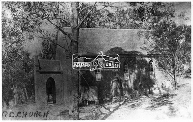
Negative - Photograph, Tom Prior, St Mary's Roman Catholic Church, Eltham, c.1900
The original St Mary’s Roman Catholic Church (1865-1912) was built of clay brick with buttress walls and a slate roof on the corner of Fordhams Road and Maria Street (Main Road), Eltham South, opposite the present-day Wingrove Park. It was blessed on September 3, 1865. With the arrival of the railway in 1901 and the town centre moving closer to the station, the decision was made to relocate the site of the church to its present-day location on Henry Street at the corner of Main Road. A new timber weatherboard church, also called St Mary's was erected and blessed on October 13, 1912. The church and land cost £1,400 (Evelyn Observer). The original brick church It was demolished in the 1920s and the bricks and windows were recycled to build a dairy on the Brinkkotter farm at Research. The timber church was destroyed by fire in 1961 and a new modern architectural (1960s) style church was erected in its place and named Our Lady of Help Christians Church.This photo forms part of a collection of photographs gathered by the Shire of Eltham for their centenary project book,"Pioneers and Painters: 100 years of the Shire of Eltham" by Alan Marshall (1971). The collection of over 500 images is held in partnership between Eltham District Historical Society and Yarra Plenty Regional Library (Eltham Library) and is now formally known as the 'The Shire of Eltham Pioneers Photograph Collection.' It is significant in being the first community sourced collection representing the places and people of the Shire's first one hundred years. The Reynolds family were early settlers in Research. The Reynolds/ Prior collection of photographs were taken by Tom Prior, the maternal uncle of Ivy Reynolds, around 1900 and the 60 photos in the album give a fine overview of many of the landmarks of Research and Eltham over 100 years ago. lvy lived in the family home for many years at 106 Thompson Cres Research. Ivy's father, Ernst Richard Reynolds and grandfather, Richard Reynolds, lived at the same address. Ivy's father Richard worked for Mr. Trail on his property in Research. Reynolds Road is named after the family. Mr Tom Prior (wife Eva) worked at the Melbourne zoo. He was very innovative and made his own camera, using the black cloth hood to exclude the light. The photographs are a reminder of the rural nature of Research and Eltham and its rich heritage.Digital image 4 x 5 inch B&W Negsepp, shire of eltham pioneers photograph collection, eltham, roman catholic church, brinkkotter, catholic church, church, reynolds prior collection, st marys catholic church -
 Eltham District Historical Society Inc
Photograph, George W. Bell, St Mary's Catholic Church, cnr Main Road and Henry Street, Eltham, c.1960
St Mary's Catholic Church, cnr Main Road and Henry Street, Eltham was opened/blessed October 13, 1912. The wooden church was built to replace an earlier brick church also known as St Mary's (1865-1912), which had been situated on the main road near present day Wingrove Park. The church and land cost £1,400 (Evelyn Observer). The wooden church was destroyed by fire in 1961. A new modern architecture (1960s) style church was erected - Our Lady of Help Christians Church. This photo forms part of a collection of photographs gathered by the Shire of Eltham for their centenary project book,"Pioneers and Painters: 100 years of the Shire of Eltham" by Alan Marshall (1971). The collection of over 500 images is held in partnership between Eltham District Historical Society and Yarra Plenty Regional Library (Eltham Library) and is now formally known as the 'The Shire of Eltham Pioneers Photograph Collection.' It is significant in being the first community sourced collection representing the places and people of the Shire's first one hundred years.Digital image 4 x 5 inch B&W Neg Print B&Wsepp, shire of eltham pioneers photograph collection, eltham, roman catholic church, church, catholic church, henry street, main road, st marys catholic church -
 Eltham District Historical Society Inc
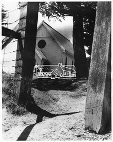
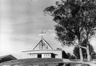
Photograph, George W. Bell, Our Lady Help of Christians Catholic Church, Henry Street, Eltham, c.1962
The second St Mary's Catholic Church Eltham was located at the corner of Main Road and Henry Street, Eltham and was opened/blessed October 13, 1912. The wooden church was built to replace an earlier brick church also known as St Mary's (1865-1912), which had been situated on the main road near present day Wingrove Park. The church and land cost £1,400 (Evelyn Observer). The wooden church was destroyed by fire in 1961. This modern (1960s) style church was built to replace the destoyed St Mary's and was called Our Lady of Help Christians. By this time Henry street had been closed off from Main Road.This photo forms part of a collection of photographs gathered by the Shire of Eltham for their centenary project book,"Pioneers and Painters: 100 years of the Shire of Eltham" by Alan Marshall (1971). The collection of over 500 images is held in partnership between Eltham District Historical Society and Yarra Plenty Regional Library (Eltham Library) and is now formally known as the 'The Shire of Eltham Pioneers Photograph Collection.' It is significant in being the first community sourced collection representing the places and people of the Shire's first one hundred years.Digital image 4 x 5 inch B&W Neg B&W printsepp, shire of eltham pioneers photograph collection, eltham, roman catholic church, churches catholic, main road, george w bell collection, our lady of help christians church -
 Eltham District Historical Society Inc
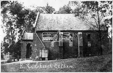
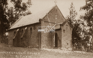
Negative - Photograph, Eltham - Old R.C. Church (building not there in 1923)
Eltham - Old R.C. Church (building not there in 1923). The original St Mary’s Roman Catholic Church (1865-1912) was built of clay brick with buttress walls and a slate roof on the corner of Fordhams Road and Maria Street (Main Road), Eltham South, opposite the present-day Wingrove Park. It was blessed on September 3, 1865. With the arrival of the railway in 1901 and the town centre moving closer to the station, the decision was made to relocate the site of the church to its present-day location on Henry Street at the corner of Main Road. A new timber weatherboard church, also called St Mary's was erected and blessed on October 13, 1912. The church and land cost £1,400 (Evelyn Observer). The original brick church It was demolished in the 1920s and the bricks and windows were recycled to build a dairy on the Brinkkotter farm at Research. The timber church was destroyed by fire in 1961 and a new modern architectural (1960s) style church was erected in its place and named Our Lady of Help Christians Church.This photo forms part of a collection of photographs gathered by the Shire of Eltham for their centenary project book,"Pioneers and Painters: 100 years of the Shire of Eltham" by Alan Marshall (1971). The collection of over 500 images is held in partnership between Eltham District Historical Society and Yarra Plenty Regional Library (Eltham Library) and is now formally known as the 'The Shire of Eltham Pioneers Photograph Collection.' It is significant in being the first community sourced collection representing the places and people of the Shire's first one hundred years.Digital image 4 x 5 inch B&W Negsepp, shire of eltham pioneers photograph collection, eltham, roman catholic church, catholic church, church, main road, st marys catholic church -
 Eltham District Historical Society Inc
Negative - Photograph, St Mary's Roman Catholic Church, Eltham, c.1910
Note the extensive cracking of the mortar and bricks in the front facade near the portico entrance. The original St Mary’s Roman Catholic Church (1865-1912) was built of clay brick with buttress walls and a slate roof on the corner of Fordhams Road and Maria Street (Main Road), Eltham South, opposite the present-day Wingrove Park. It was blessed on September 3, 1865. With the arrival of the railway in 1901 and the town centre moving closer to the station, the decision was made to relocate the site of the church to its present-day location on Henry Street at the corner of Main Road. A new timber weatherboard church, also called St Mary's was erected and blessed on October 13, 1912. The church and land cost £1,400 (Evelyn Observer). The original brick church It was demolished in the 1920s and the bricks and windows were recycled to build a dairy on the Brinkkotter farm at Research. The timber church was destroyed by fire in 1961 and a new modern architectural (1960s) style church was erected in its place and named Our Lady of Help Christians Church.This photo forms part of a collection of photographs gathered by the Shire of Eltham for their centenary project book,"Pioneers and Painters: 100 years of the Shire of Eltham" by Alan Marshall (1971). The collection of over 500 images is held in partnership between Eltham District Historical Society and Yarra Plenty Regional Library (Eltham Library) and is now formally known as the 'The Shire of Eltham Pioneers Photograph Collection.' It is significant in being the first community sourced collection representing the places and people of the Shire's first one hundred years.Digital image 4 x 5 inch B&W Neg Sepia postcardsepp, shire of eltham pioneers photograph collection, eltham, roman catholic church, church, catholic church, main road, st marys catholic church -
 Eltham District Historical Society Inc
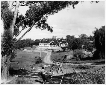
Photograph, Shire of Eltham, Petrie Park, Montmorency, November 1966
View of Petrie Park with children's playground in the foreground, sports oval to the left. Montmorency Scouts and Montmorency Bowling Club in the background. Originally identified as: Henry Petrie Community Centre.This photo forms part of a collection of photographs gathered by the Shire of Eltham for their centenary project book, "Pioneers and Painters: 100 years of the Shire of Eltham" by Alan Marshall (1971). The collection of over 500 images is held in partnership between Eltham District Historical Society and Yarra Plenty Regional Library (Eltham Library) and is now formally known as 'The Shire of Eltham Pioneers Photograph Collection.' It is significant in being the first community sourced collection representing the places and people of the Shire's first one hundred years.Digital imagesepp, shire of eltham pioneers photograph collection, montmorency, petrie park, montmorency bowling club, montmorency scouts -
 Eltham District Historical Society Inc
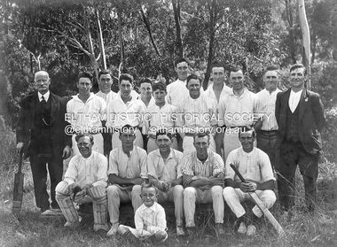
Photograph, Glen Park Cricket Club, c.1928, c.1928
... george colman george le brocq glen park cricket club henry ...Notes provided by researcher, Alan Sheehan. Photo dated about 1928 or could be earlier. Back Row (standing) L to R: Mr Le Brocq (in suit with bat), George Colman, Jack Colman, Bill Bonks, Alan Bunker, Henry Downing, Mick Le Brocq, Laurie Crisp, George Le Brocq, - , - , -; Front Row (seated) L to R: Bill Noble, - Downing, - , - Cunningham, - ; Boy in front: Ron Le Brocq. Note: George and Mick Le Brocq were brothers and sons of Mr Le Brocq in photo. Ron Le Brocq was another brother or possibly the son of Mick Le Brocq. George Le Brocq did not have any children.Black and white print mounted on embossed cardOn reverse - Glen Park Cricket Team c. 19281928, alan bunker, bill bonks, bill noble, cunningham, downing, george colman, george le brocq, glen park cricket club, henry downing, jack colman, laurie crisp, mick le brocq, mr le brocq, ron le brocq