Showing 1181 items
matching hume street
-
 Wodonga & District Historical Society Inc
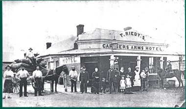
Photograph - The Carriers' Arms, Wodonga
... in Hume Street to Mr J.H. Perry. By September 1955 Edward Spencer... in Hume Street to Mr J.H. Perry. By September 1955 Edward Spencer ...In October 1874, Thomas Reidy and Andrew McCormack opened the Carriers’ Arms on the corner of South and Church Streets. They also established a general store next door, which they soon extended. The Carriers’ Arms was a coach stop for the Bethanga Express Coach. On 8 December 1882 the licence for the Carriers’ Arms was granted to Ann Reidy. In 1883, Edmund T. Powell, and his Irish-born wife, Mary Ann, purchased the Carriers’ Arms. By 1898 the Licence was in the name of M. A. Powell. She was still the licensee at the time of her death in August 1906. For a short time, the property was in the hands of Miss Maud Powell but in February 1907, the licence for The Carriers’ Arms Hotel was transferred to Mr George L. Leighton. On Monday 5th February 1917 a clearing sale of all furniture and effects of the Carriers’ Arms Hotel was held. The new proprietor and licensee was Henry R. Baker. In April 1920, the Carriers’ Arms had another new proprietor, Mrs A. E. Frauenfelder but by October 1921 it was transferred to Kathleen Hickey. Mrs. Hickey was at the Carriers’ Arms until she died in January 1926. In 1927, Mr H.W. Allen, formerly proprietor of the Terminus Hotel took over the Carriers’ Arms but in August 1928 the balance of the lease was transferred to Mrs Mulrooney. In 1932 it again changed hands, with the licence being transferred to Mrs Eileen Dorothy Hemphill, of Wodonga. In 1933 the Carriers’ Arms was licensed to Mrs. M.G. O’Brien, a sister of Mrs Hemphill. In 1935 Leo Houlihan took over the business but 6 months later it was transferred to A C Ferguson. The next year the licence was transferred yet again to Zelda Allen. By 1937 it was in the hands of Percy Cumberland then to Lila Maud MacPherson and soon followed by Ronald Dobson. By 1940 Herbert V.A. Callender had taken over the Carriers’ Arms and in 1942 the licence was transferred again to Sarah Jane Callander. In July 1943 Mr G. A. Adams disposed of the freehold of the Carriers’ Arms Hotel in Hume Street to Mr J.H. Perry. By September 1955 Edward Spencer held the Victualler’s licence for Carriers Arms Hotel and the licences was transferred to Kevin Patrick Howell. Mr Howell operated the hotel for many years. At some stage in the 1980s Geoff Milne operated the Carriers’ Arms. In 2007 he was killed in a light airplane crash. In 1991 David McLeish and Bob Craig, took over the Carriers’ Arms and were joined in 1993 by James Carroll. They continued to operate it until 2003. In 2010 Greg Evans held the Freehold with Licensees Cate Nightingale and Michael McNamara, After running into major financial difficulties it was run by Greg Evans. In 2010 the Carriers’ Arms was put up for auction but failed to sell. From 2013 - 2016, Ron Montgomery and his wife Michelle took over the lease of the Carriers’ Arms. In 2018, the Carriers’ Arms was purchased from Greg Evans by Leigh Esler. After opening to the public in 1874, The Carriers’ Arms was closed in 2019 and following extensive refurbishment opened as Church Street These items are significant as they document the history of a long-serving business in the Wodonga community.A collection of photos and advertisements documenting the life of the Carriers' Arms Hotel, Wodonga.early wodonga businesses, carriers' arms wodonga -
 Wodonga & District Historical Society Inc
Functional object - Scissors - Princess Alexandra opens Pollard Archway, Wodonga
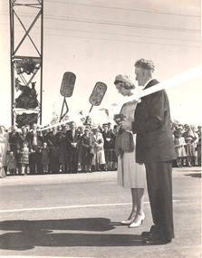
... band was driven along the Hume Highway and High Street which... band was driven along the Hume Highway and High Street which ...In 1959 Princess Alexandra of Kent visited Australia as the representative of Queen Elizabeth II for the Queensland Centenary Celebrations. Her six week visit began with her arrival in Canberra on 14th August 14 and she departed from Canberra on 26th September. Time spent in Australia included 3 weeks in Queensland. Her Royal Highness' visits to New South Wales and Victoria were comparatively brief and informal. In New South Wales she made two country visits including to Albury and a night spent at Bungowannah Park near Jindera. Her visit to Victoria began in Wodonga where she officially opened the Pollard Archway over the Causeway. She received an enthusiastic welcome as she approached the Archway accompanied by a motorcycle escort. As Princess Alexander stepped forward to take the scissors from a red plush case, her Lady-in- Waiting, Lady Moyra Hamilton, tugged at the Princess' sleeve, whispered and gave her a coin. The Princess handed the coin a halfpenny to the Wodonga Shire President, Cr J. S. Hore, saying: "I must give you this, otherwise it might be unlucky." (The halfpenny "gift" stems from an old English superstition that a "sharp" gift such as a knife or scissors must be dulled with copper or else a friendship will be lost. After cutting the ribbon and declaring the Pollard Arch, named in honour of Councillor Charles Pollard M.B.E. she was presented with a bouquet by 10-year old Leslie McLeod. Princess Alexandra led by a pipe band was driven along the Hume Highway and High Street which were lined by thousands of people including school children. After a short trip along High Street and Elgin Street to the Railway Station she departed from protocol to speak to the many children who had crossed the barricade. Princess Alexandra then boarded the Royal Train for her journey to Melbourne.This item is significant because it represents the visit to Wodonga of Princess Alexandra in 1959.A pair of scissors in a red box. The bottom of the box is lined with red cloth and the lid is lined with white silk bearing the trademark "Jewelcrest". The scissors are engraved with the maker's mark for GIESEN & FORSTHOFF/ SOLINGEN GERMANYOn top of Box. The Official Opening by Her Royal Highness Princess Alexandra of Kent 0f the Cr C F Pollard MBE Archway Wodonga 16th Sept 1959 On Scissors: GIESEN & FORSTHOFF/ SOLINGEN GERMANY TIMOR SOLINGENprincess alexandra, pollard arch -
 Kew Historical Society Inc
Plaque, Kew City Hall : Opened by The Hon H.E. Bolte M.L.A. Premier of Victoria 23rd April 1960 : Cr H.H. Ferguson J.P. Mayor, 1960
... of Remembrance (1955) and a controversial abstract sculpture at Hume... sculpture at Hume House in William Street (1957). Tenders ...The Municipality of Kew was proclaimed on 19 December 1860, then upgraded to a Borough (1863), a Town (1910) and finally a City (1921). From 1865, its offices were based in the former Athenaeum Hall in Walpole Street, which, although extended in 1883, inevitably became inadequate. Plans for a new purpose-built Town Hall were first mooted in the late 1880s, but fell prey to six subsequent decades of debate. During that time, many sites were considered and rejected, and several schemes prepared. Finally, in 1945, it was resolved to build a new civic centre as a war memorial. The council acquired Southesk, a mansion on the south-west corner of Cotham Road and Charles Street – first mooted as a possible Town Hall site two decades earlier – and plans for a civic precinct were drawn up by John Scarborough. The project stalled until 1957, when a Town Hall Committee was formed and a new architect appointed: Harold Bartlett of Leith & Bartlett. He also proposed an entire civic precinct, of which a large public hall would constitute Stage One. Designed to accommodate almost any public or official function, the space had had a small stage at one end for intimate theatrical productions, a larger stage at the other (with operable sunken orchestra pit) for musical performances, plus the most up-to-date equipment for live TV transmission. The building, befitting its original intent as a war memorial, was also to include a sculpted monument, for which a separate design competition was held. First prize went to George H Allen (1900-1972), long-time head of the Sculpture Department at RMIT and a former war artist himself (the only one, in fact, to have worked in the medium of sculpture). At the time of the Kew project, Allen was best known for his Cenotaph at the Shrine of Remembrance (1955) and a controversial abstract sculpture at Hume House in William Street (1957). Tenders for the new hall were called and the contract (worth £104,986) was awarded to H F Yuncken. The foundation stone was laid by the Mayor, Cr F C O'Brien, on 1 June 1959. Completion (initially scheduled for October) was delayed by the unavailability of certain materials; it was barely finished in time for the official opening (by Premier Henry Bolte) on 23 April 1960. The war memorial was unveiled two days later (Anzac Day) by Bolte's deputy, the Hon A G Rylah. Fittingly, that year also marked Kew's municipal centenary, and many celebratory events were held in and around the new civic centre in December, including a special council meeting (attended by the Prime Minister), a tree planting ceremony and a youth ball. Source: Survey of Built Heritage in Victoria: Stage Two (Built Heritage Pty Ltd., 2010)Plaque commemorating the opening of a new town hall in KewMetal plaque recording the official opening of the Kew City Hall, 23rd April 1960. This plaque was given to the Kew Historical Society in 1991 by the former City of Kew.Kew City Hall / Opened by / The Hon. H.E. Bolte M.L.A. / Premier of Victoria / 23rd April 1960 / Cr. H.G. Ferguson J.P. - Mayor.kew city hall, foundation stones - kew (vic), sir henry bolte, local government -- kew (vic.) -
 Kew Historical Society Inc
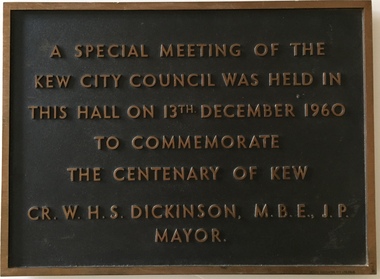
Plaque, A Special Meeting of the Kew City Council Was Held in This Hall on 13th December 1960 to Commemorate the Centenary of Kew : Cr. W.H.S. Dickinson M.B.E., J.P. Mayor, 1960
... of Remembrance (1955) and a controversial abstract sculpture at Hume... sculpture at Hume House in William Street (1957). Tenders ...The Municipality of Kew was proclaimed on 19 December 1860, then upgraded to a Borough (1863), a Town (1910) and finally a City (1921). From 1865, its offices were based in the former Athenaeum Hall in Walpole Street, which, although extended in 1883, inevitably became inadequate. Plans for a new purpose-built Town Hall were first mooted in the late 1880s, but fell prey to six subsequent decades of debate. During that time, many sites were considered and rejected, and several schemes prepared. Finally, in 1945, it was resolved to build a new civic centre as a war memorial. The council acquired Southesk, a mansion on the south-west corner of Cotham Road and Charles Street – first mooted as a possible Town Hall site two decades earlier – and plans for a civic precinct were drawn up by John Scarborough. The project stalled until 1957, when a Town Hall Committee was formed and a new architect appointed: Harold Bartlett of Leith & Bartlett. He also proposed an entire civic precinct, of which a large public hall would constitute Stage One. Designed to accommodate almost any public or official function, the space had had a small stage at one end for intimate theatrical productions, a larger stage at the other (with operable sunken orchestra pit) for musical performances, plus the most up-to-date equipment for live TV transmission. The building, befitting its original intent as a war memorial, was also to include a sculpted monument, for which a separate design competition was held. First prize went to George H Allen (1900-1972), long-time head of the Sculpture Department at RMIT and a former war artist himself (the only one, in fact, to have worked in the medium of sculpture). At the time of the Kew project, Allen was best known for his Cenotaph at the Shrine of Remembrance (1955) and a controversial abstract sculpture at Hume House in William Street (1957). Tenders for the new hall were called and the contract (worth £104,986) was awarded to H F Yuncken. The foundation stone was laid by the Mayor, Cr F C O'Brien, on 1 June 1959. Completion (initially scheduled for October) was delayed by the unavailability of certain materials; it was barely finished in time for the official opening (by Premier Henry Bolte) on 23 April 1960. The war memorial was unveiled two days later (Anzac Day) by Bolte's deputy, the Hon A G Rylah. Fittingly, that year also marked Kew's municipal centenary, and many celebratory events were held in and around the new civic centre in December, including a special council meeting (attended by the Prime Minister), a tree planting ceremony and a youth ball. Source: Survey of Built Heritage in Victoria: Stage Two (Built Heritage Pty Ltd., 2010)Historically significant commemorative plaqueMetal plaque relating to special Council meeting to mark centenary of Kew, 13th December 1960. This plaque was given to the Kew Historical Society in 1991 by the former City of Kew.A Special Meeting Of The / Kew City Council Was Held In / This Hall On 13th December 1960 / To Commemorate / The Centenary of Kew / Cr. W.H.S. Dickinson, M.B.E., J.P., / Mayorkew city hall, foundation stones - kew (vic), cr. w.h.s. dickinson, local government -- kew (vic.) -
 The Beechworth Burke Museum
Photograph
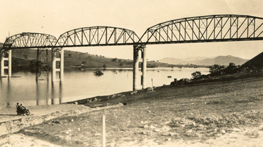
Taken between 1928 and 1930, depicted is the Bethanga Bridge under construction. The Bridge was completed in 1930 and was built to assist residents of the Bethanga district to travel to Albury. Other bridges would become submerged by the backed-up water of the Murray and Mitta Rivers so the Bethanga bridge was built two miles above the Mitta Weir. The Bethanga Bridge was built north of the future Hume Dam which would be completed in 1936. At 2430 feet long, Bethanga Bridge was the longest road bridge in Australia at the time of its completion. The Bridge is 20 feet wide and made up of nine 270 feet long spans. Materials used include ten tons of paint for the steel works; 1600 tons of steel; 900 tons of timber for the decking; and reinforced concrete for the piers. The tender for the construction was awarded to C. Ruwolt Pty. Ltd., engineers who were located on Victoria Street, West Richmond. The contract was awarded for £71,890. It was predicted between 250 and 300 men would find employment on the project. The news was well received by trade unions at the time as there had been a drop in available engineering work.This photograph is historically significant as it depicts the progress of the Bethanga Bridge construction, which was important infrastructure for the area. It is also a good example of methods used in the area to assist in travel over the river prior to the construction of the Hume Dam.Black and white rectangular photo printed on matte photographic paper.Reverse: 1997 3186 / 84-19-3 / This is the bridge. / It is not yet open to traffic / yet. will not be completed / until May next / It is a wonderful bridge the / pillars are 100 feet high. / KODAK PRINT Envelope Obverse: Peterson PHOTO / Hume Weir Envelope Reverse: BMM 84-20-1,2+3. bethanga bridge, lake hume, hume dam, hume weir, murray river, bridge, bethanga, albury -
 The Beechworth Burke Museum
Photograph, Unknown c.1930s
This image shows Bethanga Bridge, which was constructed between 1927 and 1930 in Albury, NSW. The bridge was a necessity due to the building of the Hume Dam (Wier), 1919-1936. Bethanga Bridge is a long, nine-span, riveted-steel, variable depth, Pratt Truss road bridge of nine principal spans of 82 metres and a total length of 752 metres over the flooded valley of the Murray River, now part of Hume Reservoir. Because of its unique location, over the waters of a dam with the border running down the centre of the body of water, the Bethanga bridge is the only built structure shared by both New South Wales and Victoria. It was built 1.6 kilometres upstream of the dam and in 1961 was raised 300mm, with a concrete deck replacing the original wooden deck. The State Rivers and Water Supply Commission of Victoria and the New South Wales Department of Public Works were responsible for the construction works for the Hume Weir under the River Murray Waters Agreement. It is apparent that a similar joint arrangement was made for the construction of the Bethanga Bridge as part of the Hume Weir works.This photograph of the Bethanga Bridge is of historical significance as it showcases the architectural skills of Percy Allen and Vincent Packer. Additionally, it reveals the environmental landscape of the 1920s-1930s, is linked to the Hume Dam and both New South Wales and Victorian heritage. Unmounted black and white rectangular photograph. Reverse: 1997.3196 84-20-3bethanga, bethanga bridge, hume dam, pratt truss, murray river, hume weir, transportation -
 The Beechworth Burke Museum
Photograph, c.1927-1930
This image shows the Punt (a kind of small boat) that took residents of Bethanga across the Murray River before the Bethanga Bridge was built. Bethanga Bridge was built between 1927 and 1930, and was made a necessity by the building of the Hume Dam. The Hume Dam, formerly known as the Hume Weir, was in construction between 1919 and 1936, which swelled the Murray River into the floodplain to the East of the dam permanently, creating Lake Hume, and isolating the residents of Bethanga and nearby towns, for whom the trip all the way around the new lake to another river crossing was a massive undertaking. The person who wrote on the back of this card instead chose to cross the river on a boat until the Bethanga Bridge became available. Interestingly, partially submerged trees can be seen in the lake in the background of this photograph, illustrating that the dam had already begun to fill the floodplain even before the bridge was built. This photograph shows the methods the residents of Bethanga used while the Bethanga Bridge was being built. This record is associated with the Heritage Listed sites of the Hume Dam and the Bethanga Bridge, and shows the environment during the process of construction and the creation of Lake HumeSepia rectangular photograph printed on matte photographic paperReverse: 1997.3189 / 84 -19 -1 / This is the snap of the Punt. / Our only means of getting out / of Bethanga for the present / Until the bridge is completed / it is 2 miles above the junction / of the Mitta + Murray. It is / 1/2 a mile wide + runs across / the Murray into NSW / Kodak Print / bethanga, bethanga bridge, hume, hume dam, artificial lake, lake hume, hume weir, flood, floodplain, boat, punt, weir, pier, dock, transport, transportation -
 The Beechworth Burke Museum
Photograph
Taken on 25 October 1930, various houses with the Hume Dam under construction are depicted in the background. The construction of the Hume Dam took place from 1919 to 1936. At the time of construction, it was the second largest dam in the world. It was also one of the earliest civil projects developed after the Federation. Some of the Dam workers consisted of World War I veterans. Dam workers often settled their families in Mitta Junction Village and Wodonga. Archaeological surveys were completed by Austral Archaeology, which was done when the Department of Land & Water Conservation was doing work to improve Hume Dam. The archaeological report that came out of the survey recommended three sites of interest where archaeological excavation should be done: Camp Ganger’s Quarters, Stableman’s Quarters, and the Industrial Dump. The excavation uncovered artefacts. Mitta Mitta: Mitta Mitta is situated between Mount Welcome and Mount Misery. It is named after the river that explorers Hume and Hovell discovered in 1824. The town would eventually become a huge gold mining town. Mitta Mitta is called Midamodunga by the local Indigenous peoples Wodonga: Wodonga is situated on the Murray River and is part of North East Victoria. Hume and Hovell: Hamilton Hume (1979-1873) and William Hilton Hovell (1786-1875). W. H. Hovell was born in Norfolk England and Hume was born in Parramatta, New South Wales Hovell and Hume undertook an exploration journey in 1824 and thought they discovered a river, which turned out to be the Murray River. They returned home in 1825, but returned to the area in 1826 and discovered coal in the area. This photo is historically significant as it shows the Hume Dam under construction in 1930. The Dam was named after Hamilton Hume, who is an important historical figure for this area as he helped discover the area where resources were found.Sepia rectangular photograph printed unmountedReverse: 84-19-5 / 1997.3185/ Values & spillway. / When completed the wall / will be as high as the / scaffolding. [featuring trademark: kodak print]construction, houses, veterans, mitta junction village, hume dam, world war i, federation, wodonga, archaeological survey, excavation, austral archaeology, department of land & water conservation, camp ganger's quarter's, stableman's quarters, industrial dump, artefacts, mitta mitta, mount welcome, mount misery, murray river, hamilton hume, william hilton hovell, hume and hovell expedition -
 The Beechworth Burke Museum
Photograph, c1930
Taken on 25 October 1930, various houses with the Hume Dam under construction are depicted in the background. The construction of the Hume Dam took place from 1919 to 1936. At the time of construction, it was the second largest dam in the world. It was also one of the earliest civil projects developed after the Federation. Some of the Dam workers consisted of World War I veterans. Dam workers often settled their families in Mitta Junction Village and Wodonga. Archaeological surveys were completed by Austral Archaeology, which was done when the Department of Land & Water Conservation was doing work to improve Hume Dam. The archaeological report that came out of the survey recommended three sites of interest where archaeological excavation should be done: Camp Ganger’s Quarters, Stableman’s Quarters, and the Industrial Dump. The excavation uncovered artefacts. Mitta Mitta: Mitta Mitta is situated between Mount Welcome and Mount Misery. It is named after the river that explorers Hume and Hovell discovered in 1824. The town would eventually become a huge gold mining town. Mitta Mitta is called Midamodunga by the local Indigenous peoples Wodonga: Wodonga is situated on the Murray River and is part of North East Victoria. Hume and Hovell: Hamilton Hume (1979-1873) and William Hilton Hovell (1786-1875). W. H. Hovell was born in Norfolk England and Hume was born in Parramatta, New South Wales Hovell and Hume undertook an exploration journey in 1824 and thought they discovered a river, which turned out to be the Murray River. They returned home in 1825, but returned to the area in 1826 and discovered coal in the area.This photo is historically significant as it shows the Hume Dam under construction in 1930. The Dam was named after Hamilton Hume, who is an important historical figure for this area as he helped discover the area where resources were found.Sepia rectangular photograph printed unmountedReverse: 84-19-2/ 1997.3188/ These are the four / release valves they are / not always open (illegible) this / when closed the water flows / over the spillway. [featuring trademark: kodak print] photograph number: 354construction, houses, veterans, mitta junction village, hume dam, world war i, federation, wodonga, archaeological survey, excavation, austral archaeology, department of land & water conservation, camp ganger's quarter's, stableman's quarters, industrial dump, artefacts, mitta mitta, mount welcome, mount misery, murray river, hamilton hume, william hilton hovell, hume and hovell expedition -
 The Beechworth Burke Museum
Photograph, 25 October 1930
Taken on 25 October 1930, various houses with the Hume Dam under construction are depicted in the background. The construction of the Hume Dam took place from 1919 to 1936. At the time of construction, it was the second largest dam in the world. It was also one of the earliest civil projects developed after the Federation. Some of the Dam workers consisted of World War I veterans. Dam workers often settled their families in Mitta Junction Village and Wodonga. Archaeological surveys were completed by Austral Archaeology, which was done when the Department of Land & Water Conservation was doing work to improve Hume Dam. The archaeological report that came out of the survey recommended three sites of interest where archaeological excavation should be done: Camp Ganger’s Quarters, Stableman’s Quarters, and the Industrial Dump. The excavation uncovered artefacts. Mitta Mitta: Mitta Mitta is situated between Mount Welcome and Mount Misery. It is named after the river that explorers Hume and Hovell discovered in 1824. The town would eventually become a huge gold mining town. Mitta Mitta is called Midamodunga by the local Indigenous peoples Wodonga: Wodonga is situated on the Murray River and is part of North East Victoria. Hume and Hovell: Hamilton Hume (1979-1873) and William Hilton Hovell (1786-1875). W. H. Hovell was born in Norfolk England and Hume was born in Parramatta, New South Wales Hovell and Hume undertook an exploration journey in 1824 and thought they discovered a river, which turned out to be the Murray River. They returned home in 1825, but returned to the area in 1826 and discovered coal in the area.This photo is historically significant as it shows the Hume Dam under construction in 1930. The Dam was named after Hamilton Hume, who is an important historical figure for this area as he helped discover the area where resources were found.Sepia rectangular photograph printed unmountedReverse: 84-19-6/ 1997.3187/ The spillway [featuring trademark: kodak print] construction, houses, veterans, mitta junction village, hume dam, world war i, federation, wodonga, archaeological survey, excavation, austral archaeology, department of land & water conservation, camp ganger's quarter's, stableman's quarters, industrial dump, artefacts, mitta mitta, mount welcome, mount misery, murray river, hamilton hume, william hilton hovell, hume and hovell expedition -
 The Beechworth Burke Museum
Photograph, 25 October 1930
Taken on 25 October 1930, various houses with the Hume Dam under construction are depicted in the background. The construction of the Hume Dam took place from 1919 to 1936. At the time of construction, it was the second largest dam in the world. It was also one of the earliest civil projects developed after the Federation. Some of the Dam workers consisted of World War I veterans. Dam workers often settled their families in Mitta Junction Village and Wodonga. Archaeological surveys were completed by Austral Archaeology, which was done when the Department of Land & Water Conservation was doing work to improve Hume Dam. The archaeological report that came out of the survey recommended three sites of interest where archaeological excavation should be done: Camp Ganger’s Quarters, Stableman’s Quarters, and the Industrial Dump. The excavation uncovered artefacts. Mitta Mitta: Mitta Mitta is situated between Mount Welcome and Mount Misery. It is named after the river that explorers Hume and Hovell discovered in 1824. The town would eventually become a huge gold mining town. Mitta Mitta is called Midamodunga by the local Indigenous peoples Wodonga: Wodonga is situated on the Murray River and is part of North East Victoria. Hume and Hovell: Hamilton Hume (1979-1873) and William Hilton Hovell (1786-1875). W. H. Hovell was born in Norfolk England and Hume was born in Parramatta, New South Wales Hovell and Hume undertook an exploration journey in 1824 and thought they discovered a river, which turned out to be the Murray River. They returned home in 1825, but returned to the area in 1826 and discovered coal in the area.This photo is historically significant as it shows the Hume Dam under construction in 1930. The Dam was named after Hamilton Hume, who is an important historical figure for this area as he helped discover the area where resources were found.Black and white rectangular photograph printer unmountedReverse: 84-20-1/ 1997.3147construction, houses, veterans, mitta junction village, hume dam, world war i, federation, wodonga, archaeological survey, excavation, austral archaeology, department of land & water conservation, camp ganger's quarter's, stableman's quarters, industrial dump, artefacts, mitta mitta, mount welcome, mount misery, murray river, hamilton hume, william hilton hovell, hume and hovell expedition -
 The Beechworth Burke Museum
Photograph, 25 October 1930
Taken on 25 October 1930, various houses with the Hume Dam under construction are depicted in the background. The construction of the Hume Dam took place from 1919 to 1936. At the time of construction, it was the second largest dam in the world. It was also one of the earliest civil projects developed after the Federation. Some of the Dam workers consisted of World War I veterans. Dam workers often settled their families in Mitta Junction Village and Wodonga. Archaeological surveys were completed by Austral Archaeology, which was done when the Department of Land & Water Conservation was doing work to improve Hume Dam. The archaeological report that came out of the survey recommended three sites of interest where archaeological excavation should be done: Camp Ganger’s Quarters, Stableman’s Quarters, and the Industrial Dump. The excavation uncovered artefacts. Mitta Mitta: Mitta Mitta is situated between Mount Welcome and Mount Misery. It is named after the river that explorers Hume and Hovell discovered in 1824. The town would eventually become a huge gold mining town. Mitta Mitta is called Midamodunga by the local Indigenous peoples Wodonga: Wodonga is situated on the Murray River and is part of North East Victoria. Hume and Hovell: Hamilton Hume (1979-1873) and William Hilton Hovell (1786-1875). W. H. Hovell was born in Norfolk England and Hume was born in Parramatta, New South Wales Hovell and Hume undertook an exploration journey in 1824 and thought they discovered a river, which turned out to be the Murray River. They returned home in 1825, but returned to the area in 1826 and discovered coal in the area. This photo is historically significant as it shows the Hume Dam under construction in 1930. The Dam was named after Hamilton Hume, who is an important historical figure for this area as he helped discover the area where resources were found. Black and white rectangular photograph printer unmountedReverse: 1997.3145/ 84-20-2construction, houses, veterans, mitta junction village, hume dam, world war i, federation, wodonga, archaeological survey, excavation, austral archaeology, department of land & water conservation, camp ganger's quarter's, stableman's quarters, industrial dump, artefacts, mitta mitta, mount welcome, mount misery, murray river, hamilton hume, william hilton hovell, hume and hovell expedition -
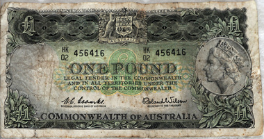 Orbost & District Historical Society
£1 note, 1966
The one pound note was the most prevalent banknote in circulation with the pound series, with the last series of 1953-66 having 1,066 million banknotes printed. The serial number HK 02 suggests it was printed in 1966.this item is an example of pre-decimal currency used in Australia.A green rectangular paper Australian £1 note. On the obverse is the Australian Coat of Arms and a picture of Queen Elizabeth II facing left. On the reverse are Charles Sturt and Hamilton Hume. The signatories are: H. C. Coombs, Governor, Reserve Bank of Australia and Roland Wilson, Secretary to the Treasury. The watermark is Captain Cook in left oval. Behind each signature is ’ONE POUND’. The serial number is HK 456416 02 currency-australia one-pound-note -
 The Beechworth Burke Museum
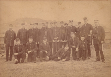
Photograph, c1885
Photograph of 19 members of the Beechworth Volunteer Fire Service and a young boy all wearing fire service uniforms.Black and white rectangular photograph printed on matte photographic paper and mounted on cardObverse: Beechworth Fire Brigade Boys / Uncle Joe Hume far right / 8187 / about 1885 / G. Bridle Photoemergency services, beechworth, fire brigade, burke museum, photograph -
 The Beechworth Burke Museum
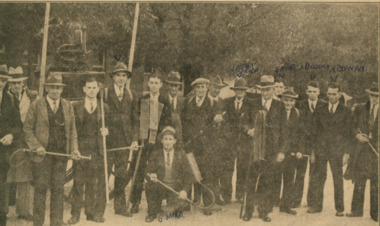
Photograph - Newspaper Article, c1900
Photograph of a group of firemen posing for newspaper article holding various fire brigade equipment that was published in the Border Morning Mail Monday 15th April 1940. Sepia rectangular newspaper reproduction printed on matte photographic paperObverse: One of the many bush fire brigade units who protect the north-east of Victoria, who paraded at Beechworth on Saturday. The group includes: Messrs. E. Jessup, F.Paton, G. Witherow, J. Carney, M. Sonneman, K. Allen, G. Wald, W. Rae, W. Lee, D. Hume, J. Morrison J. Neary, A.D. Neary, J. Witherow, A.J Goonan, R. Hupwood and W. Shannon. Reverse: 7625.1emergency services, beechworth, burke museum, newspaper article, photograph, fire brigade, fire, firemen -
 Glen Eira Historical Society
Document - ‘KENLY’, Gladstone Parade, 34, Elsternwick
This file contains two items about this property: 1/Photocopy of Caulfield conservation study on ‘Kenly’ (1899) completed by Andrew Ward in October 1994. Includes a brief history of owners and tenants from 1888 to 1941 and a description of its architectural features as well as a black and white exterior photograph. 2/Two colour exterior photographs dated 13/10/2011gladstone parade, elsternwick, ‘kenly’, house names, 21-aug-18, mansions, hume c., kooyong park estate, clarence street, jackson thomas b., shoobra road, wells andrew, ford grylls, langwill p., henriques fred, pearson alfred, edmends james, williamson alfred, caulfield, ward andrew, architectural styles, victorian style, verandahs, brick houses, windows -
 Glen Eira Historical Society
Document - Murrumbeena Baptist Church, Murrumbeena Road, 44
Reprinted history of Murrumbeena Baptist Church 1890 – 1990 compiled for the church’s centenary celebrations in 1990 by Ross Harrison Snow and Geoft Barthold. Each chapter details certain periods of church history and associated events Handwritten notes, including wording on foundation stone, by person unknown & undatedmurrumbeena, murrumbeena baptist church, pitt annie sophia, dandenong road., george samuel, baptist church, emily street, whitlam janet, box henry, snow ross harrison, gallop abel, pay henry mrs., rollings william, barthold geoff, thomas pay, pay e – miss godfrey, w- mrs, pitt st clair percival, godfrey william, pay t. a. h – mrs, blair mrs, white mrs, shearer mrs., box marie miss, box nellie miss, gallop prudence miss, gallop e. j. miss, rosstown wesleyan churches, murrumbeena baptist church, churches, gresswell f. l. mrs, neerim road, public halls, murrumbeena railway station, union chapel, kangaroo road, oakleigh, cole. j. h., turner mr., williamson r. rev, stewart allan., rosstown., architects, laver and flick messrs, mayhew george mr., chambers a. r. mr., godfrey brother, whitley w. t. rev., williamson rev., endersby elizabeth miss., meehani francis, french john, whyte mrs., thompson isabella mrs., burgess mary mrs., organ, tarry j. brother, mclean donald f. rev., wilkins george mr., sutherland mr., sydney street, nopkins ivor. rev, gallop mrs, pay brother, pitt brother, hopkins mrs, thompson ethel. miss, thompson mabel. miss, lavender mr. fred, whitlam george. master, varley frank mr, whitlam fred. mr, varley mrs, hale g. e. rev., whitlam crissie miss, curnick elizabeth miss, byrne mr, clemens f. rev., tennis club, tennis courts, cheffer mr., peace george mr., green mr., nash w. f rev., earl stanley j. rev, earl mrs., parker miss, adelaide street 12 manses, endersby david, harvey nellie. miss, fasham f. miss, mills mr., kelly mr., dyason mr, mckeon mr, lavender b. mr., chaffey alf, nelson norman, guthrie andrew, hopkins mrs., kindergarten, girl guides, loyal orange lodge, hall, fire, juniour christian endeavour league, intermediate christian, endeavour society, endersby mr, wilkins mr, wills mr, kelley mr, golden jubilee 22- 29 sept. 1940, knight e. o. rev, marriott e staunton m stone j., clay clark e. messrs, carter mr, carter mrs, deacenesses, helmore p. h. mrs, ryall c. m. mrs, carbis l. miss, wilson a. mrs, clark e. j. mrs, cornock m. miss, smith a. w. rev, mcdonald h. miss, stewart j. miss, edwards. w. messrs, crowe m. messrs, diggins l. messrs, wilson k. mr, ryall c. m. mr., wright a. mr., watkins mr., smith k. a. rev, scout groups, hobart street – 59 manses, helmer p. mr, filmer mr, carter mr., staunton martin mr., lewis donald rev 1951- 1956, perri john, collrus barry, ferguson mrs, white mrs, outhread noel mr., burleigh betty miss, orchestras, clark ted mr., daniels alan mr, staunton keith mr., staunton martin mr, steer doug mr, pascoe vack mr., ryall mert mr., clay ken mr., carter francis mr., chambers harry mr, hendry t. j. mr, andrews. e. f. rev, venning frank, provis keith, lee milton f. rev, kingdom max rev, kingdom fredq, allison c., eleiner e mrs, provis jan miss, chambers merle miss, collicot allison miss, cook john, cook family, horn neville rev, horn family, benneld family, bennett john., bennetts cliff, wiesmayrs’ family, allison barbara miss, jones ross, jones joy, fverst walter, doyle family, bertram estelle, bertram family, saletta margaret, saletta len, close kevin, close family, close anne, stewart des, stewart family, peel family, fisher family, leis family, arms harry, jones ross, jones family, jones joy, langdon family, bertram bill, staunton ian, staunton yvonne, staunton jean, staunton keith, staunton martin, clifferd. patricia, clifferd. charles, chambers awen, wall brian, wall bev, ryall geoff, ryall kay, ryall edna, davidson max, davidson mary, freeman john, hendry t s, provis keith, terrington michael, terrington doreen, carbis hazel miss, butterworth ern, clay ken, clay mrs., clay judith, clay noelle, muller ron, cook john, kingdom joy, kingdom graham, strong david, owens cliff, chambers harry, christy family, warr bill dr., morrison grace mrs., soderholm harvey, soderholm mrs, harris jeanette mrs, harris trevor rev., freeman pauline, freeman john., hendry t. j., steer doug, owens allison, owens graham, henderson ray, henderson chris, rathbone ian, rathbone pat, jenkins marion, girls’ club, wilson cliff dr., ladies evening group (legs), anderson family, l’ amont family, powell harold., harris luke, harris trevor, davies mrs, young george, anderson russell, wade joan, sauvarin lois, hill fred, wilson david., hansell fiona, hansell jane, brammer leanne, bertram ruth, langton john, crowe ken, dobney john, nobbs steve, jordan mr., steer david., steer doug, murrumbeena christian education centre (cec), suggare alwyn, gray s. mr., wilson clive rev., jephcott hume, jephcott heather, mccleary ross, mccleary glenn, claringbold mary, bennetts marcia., langton phil, worthy reg, thomson ave, mckerlie darrell rev., henderson ray, langenberg stewart van, crowe malcolm., sydney street, wall brian, zegelis imants, allison doug, owens rhonda, anderson peter, provis ken, vaitch fay, longenberg roger van, ife david, warren lena, churches bruce, churches mrs, bennetts john, mcdonald. k., cathie ian., cathie wendy, wright norman rev., alma street, mckerlie darrell rev., hampton keith rev., robinson john rev, jolly rod, crowe malcolm, lakey m, ferdinands ann, ferdinands ken, inders brett, inders jenny, cooke stephen, cooke deanne, langenberg jeremy van, binks paul, wall john, leslie geoff, leslie debbie, macleod nelson, macleod heather, dalton steven, pugh jeff, jones ross, ceulson joy, jackel lindsay, jackel sue, berry graham, wall brian, wheatland don, langton phil, stewart margaret, wheatland elise, wall bev., chambers gwen., foundation stone, morley john rev., sunday seekers, young marrieds, mothers’ group, choirs, walrond cw, turner mr, chisholm mr, mcdonald mr, church furniture, williams brother, sunday schools, victorian baptist preachers’ society, pitt mrs, thompson m miss., pitt w. miss, pay miss, thompson e. mrs., stained glass, christian endeavour society, young worshipper’ league, baptist women’s association, men’s society, murrembeena baptist football club, children’s church, youth council, junior christian endeavour, buds, baptist girls’ fellowship, boys club, baptist men’s society, youth fellowship life boys, boys brigade, alma street 17 chadstone manse, one way searchers’ group -
Glen Eira Historical Society
Document - Lincoln, Clarence Street, 33, Elsternwick
Photo copy of extract from caulfield Conservation study of “Lincoln” formerly “Kiora” (1913) 33 Clarence Street caulfield, conducted by Andrew Ward in October 1994. This was one of four houses built by architect A.J.Smith in the 1880s. A brief history of the house and a description of the architectural features included. One exterior photograph.caulfield, clarence street, kiora, lincoln, kooyong park, estate, gladstone parade, kooyong road, gudgeon wilfred, hume mrs, hume thomas, emmerson mary, emmerson joseph, finlay a. mrs, harper jessie -
Glen Eira Historical Society
Document - Monkleigh, Gladstone Parade, 12, Elsternwick
Three items aout this property:1/Copy of pages from Andrew Wards, Caulfield Conservation study document dated October, 1994. Gives a brief history of land owners and occupants of Monkleigh and copy of photo dated October, 1994. The document includes a brief history and a description of the house features. 2/Hand written research by Claire Barton taken from 'Trove' regarding former resident of 'Monkleigh' who went to World War One. 3/Printout dated 18/02/2014 from Roll of Honour - Charles Clifton Elliott with location of his name at theralian War Memorial.elsternwick, hume lucy, kooyong park estate, gladstone parade, gladstone road, carlingford street, ellis jabez, webster joseph, wimberley colin, vale chas., judge g.t., ward andrew, architectural styles, victorian style, architectural features, monkleigh, elliot charles clifton, elliott charles clifton, elliot e b mrs, elliott e b mrs, house names, station managers, world war 1914-1918 -
Glen Eira Historical Society
Document - Eversley, Gladstone Parade, 36, Elsternwick
A two page photocopy from the Caulfield Conservation Study by Andrew Ward on the house Eversley at 36 Gladstone Parade. The study includes a brief description of the building, building history, a statement of significance and a black and white photograph (100mm x 155mm) of the exterior of the house. The file also includes a poor quality black and white photograph (88mm x 88mm) of the exterior of the house.architectural features, gladstone parade, nulmore, brampton, eversley, kooyong park estate, clarence street, jackson b thomas, architect, shoobra road, dalrymple william, barbeta augustine, langwill p, ainslie james, henriques frederick, hume c, jackson thomas b, ward andrew -
 Eltham District Historical Society Inc
Photograph, Hume and Hovell passed here at Seymour 28 Oct 1824, Spring Excursion, Hume and Hovell's 1824 expedition (Part 2), 26 October 1997, 26/10/1997
[article by Diana Bassett-Smith in EDHS Newsletter No. 117, November 1997:] MONUMENT HUNTING THE HUME AND HOVELL WAY - Sunday October 26 1997 dawned bright and very warm. Some twenty-five members, complete with picnic baskets, met outside the Eltham Library awaiting the Cobb and Co. large coach which would be taking us on the second leg of our travels along the route of the early explorers Hume and Hovell. Stephen West was our very good driver for the day. He would be guided around the circuitous route by Russell Yeoman who had made a detailed study, not only of the intended route, but of the story of these two explorers. During the trip Russell regaled us with poetry, quotations from the Journals and the History of the Shire of Seymour, "The New Crossing Place" by Martindale, 1982, (now Mitchell Shire due to the recent amalgamations). We headed towards the Hume Highway via Greensborough and Cooper Street and proceeded north to our first stop, noting on the way Monument Hill in the distance which is near Kilmore and, according to Russell, well worth the effort to visit as the view across the valley is magnificent. Past Sunday Creek Valley, Mt Piper and Mt Disappointment, all traversed and noted and named by them. We passed through Tallarook, then onto Seymour where we took photos of the monument telling us that Hume and Hovell had passed through on the 28th of October 1824. We also deviated down Hume and Hovell Road viewing deer and emu farming and the Bellbourie property now a sanctuary. Leaving Seymour behind we travelled up the Avenel Road to the Avenel monument, pyramidal in design of four reducing square blocks with a sharply pointed peak, erected in 1924 in memory of the 1824 exploration. The day was warming up and the countryside showing the dryness of the current drought. A parallel note had been made in their journal too of 1824 of the drought appearance of the country they were traversing. At Seven Creeks, Euroa we stopped for some minutes to check the monument placed 20th November 1924 to commemorate their passage on the 29th December 1824. More photos. Russell had pointed out the abrupt termination of the distant ranges which is noted in their journal. The next monument is beside the road at the entrance to Honey Suckle Creek Caravan Park, Violet Town. The squarish shaped monument some eight feet high is topped with a simple steel cross, and was to mark the date of 28th December 1824 and built for the 20th November 1924. By now it was 12.20 and nearly lunchtime as we drove along the Warranbayne Road to Roach's Road, monument hunting without success. Though there is a large, what appears to be an old timber sign which was hard to read, maybe this was the lost monument. In many of the paddocks hay had been cut and baled or was being cut, what a contrast to the rugged country they had passed through which was smoky from the fires of the natives burning off. By 1.00 pm we were at Benalla and pulled up beside the park where abundant beds of roses filled the air with their scent and the smell of barbecued food twitched the nostrils whilst the cheerful sounds of other picnickers could be heard throughout the park. We left the bus and collected up our picnics, dispersed to the various tables and enjoyed the shade from the various European trees. 2.00 pm and we were on the road again driving along the Benalla, Mansfield, Yea road. The Swanpool monument states that they passed four miles south and returned three miles north. Then we stopped at the Barjarg monument which notes that they camped near this spot. It is again a pyramidal monument and this time topped with a steel arrow indicating their route of the 29th November 1824. Half an hour later we came to another monument, again with a steel arrow marker on top and the plaque dated the 2nd of 12th 1824. Erected on the 12th of 12th 1924. "They blazed the way that we might inherit the land." Another square based and needle topped monument appeared at Yarck near Yea and this plaque records the date of 3 December 1824. Near McGuigans Road Russell related that the expedition had lost a dog but it had found them next day, the dog was apparently torn by a kangaroo. A short while later Russell reminded us here of the problems they encountered in crossing the Goulburn River near Molesworth where banks were high, water deep and wide. "Good coat of grass but quite dry due to drought". At Yea we stopped for afternoon tea and raided the last of our picnics and looked at the monument to their journey of 1824, situated at a corner of the gardens near the bowling green. No photo – we were out of film. We returned home via Kinglake West and Whittlesea past the Yan Yean Reservoir, not full. 5.00 pm back at Eltham we emptied out of the bus and everyone, including Joan Cole, collected their things, Joan also had the major souvenir of the day, a large carp she had picked up from the river bank, her cat was in for a great feast. The day was made so interesting by the informed commentary which Russell provided. His background knowledge of the route and nature of the journey could only have come from many hours of reading and driving the area. Thank you to Russell and to everyone who made the day so informative and pleasurable. Colour photographactivities, hume and hovell, monument, seymour -
 Eltham District Historical Society Inc
Photograph, Spring Excursion, Hume and Hovell's 1824 expedition (Part 2), 26 October 1997, 26/10/1997
[article by Diana Bassett-Smith in EDHS Newsletter No. 117, November 1997:] MONUMENT HUNTING THE HUME AND HOVELL WAY - Sunday October 26 1997 dawned bright and very warm. Some twenty-five members, complete with picnic baskets, met outside the Eltham Library awaiting the Cobb and Co. large coach which would be taking us on the second leg of our travels along the route of the early explorers Hume and Hovell. Stephen West was our very good driver for the day. He would be guided around the circuitous route by Russell Yeoman who had made a detailed study, not only of the intended route, but of the story of these two explorers. During the trip Russell regaled us with poetry, quotations from the Journals and the History of the Shire of Seymour, "The New Crossing Place" by Martindale, 1982, (now Mitchell Shire due to the recent amalgamations). We headed towards the Hume Highway via Greensborough and Cooper Street and proceeded north to our first stop, noting on the way Monument Hill in the distance which is near Kilmore and, according to Russell, well worth the effort to visit as the view across the valley is magnificent. Past Sunday Creek Valley, Mt Piper and Mt Disappointment, all traversed and noted and named by them. We passed through Tallarook, then onto Seymour where we took photos of the monument telling us that Hume and Hovell had passed through on the 28th of October 1824. We also deviated down Hume and Hovell Road viewing deer and emu farming and the Bellbourie property now a sanctuary. Leaving Seymour behind we travelled up the Avenel Road to the Avenel monument, pyramidal in design of four reducing square blocks with a sharply pointed peak, erected in 1924 in memory of the 1824 exploration. The day was warming up and the countryside showing the dryness of the current drought. A parallel note had been made in their journal too of 1824 of the drought appearance of the country they were traversing. At Seven Creeks, Euroa we stopped for some minutes to check the monument placed 20th November 1924 to commemorate their passage on the 29th December 1824. More photos. Russell had pointed out the abrupt termination of the distant ranges which is noted in their journal. The next monument is beside the road at the entrance to Honey Suckle Creek Caravan Park, Violet Town. The squarish shaped monument some eight feet high is topped with a simple steel cross, and was to mark the date of 28th December 1824 and built for the 20th November 1924. By now it was 12.20 and nearly lunchtime as we drove along the Warranbayne Road to Roach's Road, monument hunting without success. Though there is a large, what appears to be an old timber sign which was hard to read, maybe this was the lost monument. In many of the paddocks hay had been cut and baled or was being cut, what a contrast to the rugged country they had passed through which was smoky from the fires of the natives burning off. By 1.00 pm we were at Benalla and pulled up beside the park where abundant beds of roses filled the air with their scent and the smell of barbecued food twitched the nostrils whilst the cheerful sounds of other picnickers could be heard throughout the park. We left the bus and collected up our picnics, dispersed to the various tables and enjoyed the shade from the various European trees. 2.00 pm and we were on the road again driving along the Benalla, Mansfield, Yea road. The Swanpool monument states that they passed four miles south and returned three miles north. Then we stopped at the Barjarg monument which notes that they camped near this spot. It is again a pyramidal monument and this time topped with a steel arrow indicating their route of the 29th November 1824. Half an hour later we came to another monument, again with a steel arrow marker on top and the plaque dated the 2nd of 12th 1824. Erected on the 12th of 12th 1924. "They blazed the way that we might inherit the land." Another square based and needle topped monument appeared at Yarck near Yea and this plaque records the date of 3 December 1824. Near McGuigans Road Russell related that the expedition had lost a dog but it had found them next day, the dog was apparently torn by a kangaroo. A short while later Russell reminded us here of the problems they encountered in crossing the Goulburn River near Molesworth where banks were high, water deep and wide. "Good coat of grass but quite dry due to drought". At Yea we stopped for afternoon tea and raided the last of our picnics and looked at the monument to their journey of 1824, situated at a corner of the gardens near the bowling green. No photo – we were out of film. We returned home via Kinglake West and Whittlesea past the Yan Yean Reservoir, not full. 5.00 pm back at Eltham we emptied out of the bus and everyone, including Joan Cole, collected their things, Joan also had the major souvenir of the day, a large carp she had picked up from the river bank, her cat was in for a great feast. The day was made so interesting by the informed commentary which Russell provided. His background knowledge of the route and nature of the journey could only have come from many hours of reading and driving the area. Thank you to Russell and to everyone who made the day so informative and pleasurable. Colour photographactivities, hume and hovell, bridge -
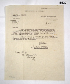 Bendigo Military Museum
Letter - LETTER OF APPOINTMENT, Department of Civil Aviation and D.G. Anderson for the Director of Airways, 18th April, 1949
Letter advised F.G. Davey of an appointment with the Department of Civil Aviation. Davey initially wanted to be a commercial pilot after returning from WW2. He qualified to do so but eventually chose to return to his pre-war job as a clerk at Hume and Iser, Bendigo. Part of F.G. Davey collection. See catalogue no. 3536P for his service record.Single page letter in black type on cream paper under the commonwealth of Australia - Department of Civil Aviation letterhead. Handwritten appointment details appear in black ink.Handwritten in black ink: '18.4.47'. Handwritten indecipherable signature in black ink. Handwritten address in black ink: 'Davey F.G. 88 Olinda Street, Bendigo, Vic'. Handwritten appointment time: 'Thursday 24th 1030'.f.g. davey, letter, department of civil aviation -
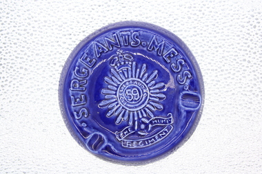 Shepparton RSL Sub Branch
Blue "Sergeants Mess" 59th Battalion ashtray, Royal Blue glazed 'Sergeants Mess' 59th battalion Ashtray, > 1960's
From SOMME Barracks Shepparton Sgts Mess Royal Blue coloured ceramic circular ashtraySergeants Mess 'FIDELIS ET AUDAX' 59 The Hume Regiment -
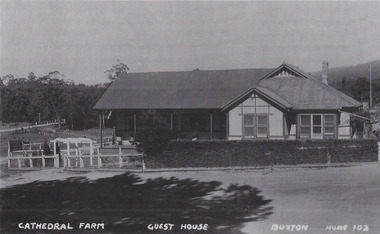 Marysville & District Historical Society
Photograph (Item) - Black and white photograph, Unknown
A black and white photograph of Cathedral Farm at Buxton.A black and white photograph of Cathedral Farm at Buxton.CATHEDRAL FARM GUEST HOUSE BUXTON HUME 103buxton, victoria, australia, cathedral farm, guest house, accommodation -
Glenelg Shire Council Cultural Collection
Photograph - Photograph Album - Photos of Victoria, c. 1948
Photograph album, green covers, contains black and white photos of Canberra, Gippsland, Albury, Hume Weir, Gundagai, and the Grampians. -
 Eltham District Historical Society Inc
Photograph, Spring Excursion, Hume and Hovell bus tour Stage 2, Seymour, Benalla; 26 Oct 1997, 26/10/1997
MONUMENT HUNTING THE HUME AND HOVELL WAY (Newsletter No. 117, November 1997, by Diana Bassett-Smith) Sunday October 26 1997 dawned bright and very warm. Some twenty-five members, complete with picnic baskets, met outside the Eltham Library awaiting the Cobb and Co. large coach which would be taking us on the second leg of our travels along the route of the early explorers Hume and Hovell. Stephen West was our very good driver for the day. He would be guided around the circuitous route by Russell Yeoman wh9 had made a detailed study, not only of the intended route, but of the story of these two explorers. During the trip Russell regaled us with poetry, quotations from the Journals and the History of the Shire of Seymour, "The New Crossing Place: by Martindale, 1982, (now Mitchell Shire due to the recent amalgamations). We headed towards the Hume Highway via Greensborough and Cooper Street and proceeded north to our first stop, noting on the way Monument Hill in the distance which is near Kilmore and, according to Russell, well worth the effort to visit as the view across the valley is magnificent. Past Sunday Creek Valley, Mt Piper and Mt Disappointment, all traversed and noted and named by them. We passed through Tallarook, then onto Seymour where we took photos of the monument telling us that Hume and Hovell had passed through on the 28th of October 1824. We also deviated down Hume and Hovell Road viewing deer and emu farming and the Bellbourie property now a sanctuary. Leaving Seymour behind we travelled up the Avenel Road to the Avenel monument, pyramidal in design of four reducing square blocks with a sharply pointed peak, erected in 1924 in memory of the 1824 exploration. The day was warming up and the countryside showing the dryness of the current drought. A parallel note had been made in their journal too of 1824 of the drought appearance of the country they were traversing. At Seven Creeks, Euroa we stopped for some minutes to check the monument placed 20th November 1924 to commemorate their passage on the 29th December 1824. More photos. Russell had pointed out the abrupt termination of the distant ranges which is noted in their journal. The next monument is beside the road at the entrance to Honey Suckle Creek Caravan Park, Violet Town. The squarish shaped monument some eight feet high is topped with a simple steel cross, and was to mark the date of 28th December 1824 and built for the 20th November 1924. By now it was 12.20 and nearly lunchtime as we drove along the Warranbayne Road to Roach's Road, monument hunting without success. Though there is a large, what appears to be an old timber sign which was hard to read, maybe this was the lost monument. In many of the paddocks hay had been cut and baled or was being cut, what a contrast to the rugged country they had passed through which was smoky from the fires of the natives burning off By 1.00 pm we were at Benalla and pulled up beside the park where abundant beds of roses filled the air with their scent and the smell of barbecued food twitched the nostrils whilst the cheerful sounds of other picnickers could be heard throughout the park. We left the bus and collected up our picnics, dispersed to the various tables and enjoyed the shade from the various European trees. 2.00 pm and we were on the road again driving along the Benalla, Mansfield, Yea road. The Swanpool monument states that they passed four miles south and returned three miles north. Then we stopped at the Barjarg monument which notes that they camped near this spot. It is again a pyramidal monument and this time topped with a steel arrow indicating their route of the 29th November 1824. Half an hour later we came to another monument, again with a steel arrow marker on top and the plaque dated the 2nd of 12th 1824. Erected on the 12th of 12th 1924. "They blazed the way that we might inherit the land." Another square based and needle topped monument appeared at Yarck near Yea and this plaque records the date of 3 December 1824. Near McGuigans Road Russell related that the expedition had lost a dog but it had found them next day, the dog was apparently torn by a kangaroo. A short while later Russell reminded us here of the problems they encountered in crossing the Goulburn River near Molesworth where banks were high, water deep and wide. "Good coat of grass but quite dry due to drought". At Yea we stopped for afternoon tea and raided the last of our picnics and looked at the monument to their journey of 1824, situated at a corner of the gardens near the bowling green. No photo – we were out of film. We returned home via Kinglake West and Whittlesea past the Yan Yean Reservoir, not full. 5.00 pm back at Eltham we emptied out of the bus and everyone, including Joan Cole, collected their things, Joan also had the major souvenir of the day, a large carp she had picked up from the river bank, her cat was in for a great feast. The day was made so interesting by the informed commentary which Russell provided. His background knowledge of the route and nature of the journey could only have come from many hours of reading and driving the area. Thank you to Russell and to everyone who made the day so informative and pleasurable. Diana Bassett-Smith. Record of the Society's history of activities - Spring 1997 excursionRoll of 35mm colour negative film, 6 stripsFuji 200shire of eltham historical society, activities, pretty hill, seymour, benalla, hume and hovell, monuments -
 Eltham District Historical Society Inc
Photograph, Spring Excursion, Hume and Hovell bus tour Stage 2, Seymour, Benalla; 26 Oct 1997, 26/10/1997
MONUMENT HUNTING THE HUME AND HOVELL WAY (Newsletter No. 117, November 1997, by Diana Bassett-Smith) Sunday October 26 1997 dawned bright and very warm. Some twenty-five members, complete with picnic baskets, met outside the Eltham Library awaiting the Cobb and Co. large coach which would be taking us on the second leg of our travels along the route of the early explorers Hume and Hovell. Stephen West was our very good driver for the day. He would be guided around the circuitous route by Russell Yeoman wh9 had made a detailed study, not only of the intended route, but of the story of these two explorers. During the trip Russell regaled us with poetry, quotations from the Journals and the History of the Shire of Seymour, "The New Crossing Place: by Martindale, 1982, (now Mitchell Shire due to the recent amalgamations). We headed towards the Hume Highway via Greensborough and Cooper Street and proceeded north to our first stop, noting on the way Monument Hill in the distance which is near Kilmore and, according to Russell, well worth the effort to visit as the view across the valley is magnificent. Past Sunday Creek Valley, Mt Piper and Mt Disappointment, all traversed and noted and named by them. We passed through Tallarook, then onto Seymour where we took photos of the monument telling us that Hume and Hovell had passed through on the 28th of October 1824. We also deviated down Hume and Hovell Road viewing deer and emu farming and the Bellbourie property now a sanctuary. Leaving Seymour behind we travelled up the Avenel Road to the Avenel monument, pyramidal in design of four reducing square blocks with a sharply pointed peak, erected in 1924 in memory of the 1824 exploration. The day was warming up and the countryside showing the dryness of the current drought. A parallel note had been made in their journal too of 1824 of the drought appearance of the country they were traversing. At Seven Creeks, Euroa we stopped for some minutes to check the monument placed 20th November 1924 to commemorate their passage on the 29th December 1824. More photos. Russell had pointed out the abrupt termination of the distant ranges which is noted in their journal. The next monument is beside the road at the entrance to Honey Suckle Creek Caravan Park, Violet Town. The squarish shaped monument some eight feet high is topped with a simple steel cross, and was to mark the date of 28th December 1824 and built for the 20th November 1924. By now it was 12.20 and nearly lunchtime as we drove along the Warranbayne Road to Roach's Road, monument hunting without success. Though there is a large, what appears to be an old timber sign which was hard to read, maybe this was the lost monument. In many of the paddocks hay had been cut and baled or was being cut, what a contrast to the rugged country they had passed through which was smoky from the fires of the natives burning off By 1.00 pm we were at Benalla and pulled up beside the park where abundant beds of roses filled the air with their scent and the smell of barbecued food twitched the nostrils whilst the cheerful sounds of other picnickers could be heard throughout the park. We left the bus and collected up our picnics, dispersed to the various tables and enjoyed the shade from the various European trees. 2.00 pm and we were on the road again driving along the Benalla, Mansfield, Yea road. The Swanpool monument states that they passed four miles south and returned three miles north. Then we stopped at the Barjarg monument which notes that they camped near this spot. It is again a pyramidal monument and this time topped with a steel arrow indicating their route of the 29th November 1824. Half an hour later we came to another monument, again with a steel arrow marker on top and the plaque dated the 2nd of 12th 1824. Erected on the 12th of 12th 1924. "They blazed the way that we might inherit the land." Another square based and needle topped monument appeared at Yarck near Yea and this plaque records the date of 3 December 1824. Near McGuigans Road Russell related that the expedition had lost a dog but it had found them next day, the dog was apparently torn by a kangaroo. A short while later Russell reminded us here of the problems they encountered in crossing the Goulburn River near Molesworth where banks were high, water deep and wide. "Good coat of grass but quite dry due to drought". At Yea we stopped for afternoon tea and raided the last of our picnics and looked at the monument to their journey of 1824, situated at a corner of the gardens near the bowling green. No photo – we were out of film. We returned home via Kinglake West and Whittlesea past the Yan Yean Reservoir, not full. 5.00 pm back at Eltham we emptied out of the bus and everyone, including Joan Cole, collected their things, Joan also had the major souvenir of the day, a large carp she had picked up from the river bank, her cat was in for a great feast. The day was made so interesting by the informed commentary which Russell provided. His background knowledge of the route and nature of the journey could only have come from many hours of reading and driving the area. Thank you to Russell and to everyone who made the day so informative and pleasurable. Diana Bassett-Smith. Record of the Society's history of activities - Spring 1997 excursionRoll of 35mm colour negative film, 6 stripsFuji 200shire of eltham historical society, activities, pretty hill, seymour, benalla, hume and hovell, monuments