Showing 159 items matching "hustler's reef mine"
-
 Bendigo Historical Society Inc.
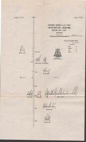
Map - STRUGNELL COLLECTION: UNITED HUSTLER'S & REDAN MINE, September 1913
... Hustler's & Redan Mine, Hustler's Line of Reef, Bendigo. Plate... & Redan Mine, Hustler's Line of Reef, Bendigo. Plate No. XXX (30 ...Map, Transverse Sections N. & S. Of shaft, United Hustler's & Redan Mine, Hustler's Line of Reef, Bendigo. Plate No. XXX (30).Bulletin No 33 Signed H.A.Whitelaw. Drawing shows the vertical shaft descending to over 976 feet and appears to show samples of connecting horizontal shafts with their respective mineral contentsUnderground Survey Office, Bendigo.map, bendigo, hustler's & redan mine -
 Bendigo Historical Society Inc.
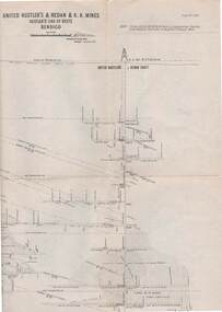
Map - STRUGNELL COLLECTION: UNITED HUSTLER'S & REDAN & K.K.MINES, September,1913
Map, United Hustler's & Redan & K.K.Mines, Hustler's Line of Reefs, Bendigo.Plat No.XXX1(31),. NOTE:- Plates 4,8,13,20,26,& 31 form a Longitudinal Section from Fortuna Hustler's to Hystler's Consols Mine. Bulletin 33.Signed H.A.Whitelaw. Drawing shows the vertical shafts descending to over 1932 feet and 1805 feet respectively .Underground Survey Office, Bendigo.map, bendigo, united hustler's, redan, k.k.mines -
 Bendigo Historical Society Inc.
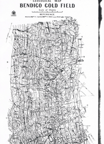
Map - LONG GULLY HISTORY GROUP COLLECTION: GEOLOGICAL MAP - BENDIGO GOLD FIELD
Copy of a Geological Map of the Bendigo Gold Field. Map shows Lines of Reef, Anticlines, Synclines, Shafts, Alluvial Contours Gullies and some street names. Copy is hard to read. There are two pages.bendigo, history, long gully history group, the long gully history group - geological map - bendigo gold field, mines department, h herman, lightning hill line, hustlers line, derby line, paddy's gully line, garden gully line, deborah line, sheepshead line, new chum line, nell gwynne line, british and foreign line, napoleon line, carshalton line, thistle line, christmas line, lancashire line -
 Bendigo Historical Society Inc.
Document - LONG GULLY HISTORY GROUP COLLECTION: GOLD MINING
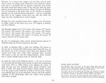
Copy of page 52 from a book. Mentioned are nuggets of gold. Some large Bendigo nuggets and their weight in ounces are mentioned, but no names of the nuggets. Some yields from shaft mining are also mentioned. The Pearl Mine and the Victoria Quartz did a lot of work without sighting any gold, while nearby at the Wittschiebe shaft there was a good find. There is also a short piece about the Pearl Mine Battery. It belongs to photo that was on the next page.bendigo, history, long gully history group, the long gully history group - gold mining, hustlers hill, victoria hill, st laurence court, anglo-german, pearl mine, victoria quartz, wittschiebe shaft, new chum reef, danger hill, belltopper hill -
 Bendigo Historical Society Inc.
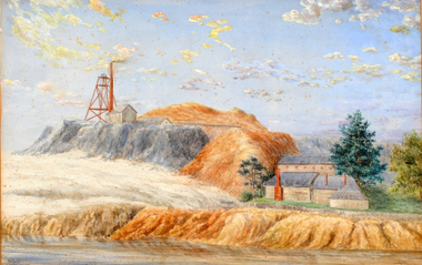
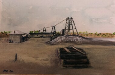
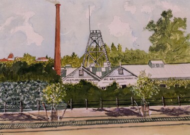
Artwork, other - Hustlers Reef Paintings, 1901
The century-old paintings of Bendigo gold mines made the long journey home from Western Australia in 2012. The paintings of the Great extended Hustler’s Mine, Bendigo, and Koch’s Pioneer Gold Mine, Long Gully, were painted by C.G Robertson in 1901.For years the paintings sat in the Perth house of Charles and Grace Strue; however Ian and Katinka Napier, the grand-daughter of Mr and Mrs Strue, donated the paintings to the Bendigo Historical Society.DVD. Hustler's Gold. Hustlers Reef paintings. artist C G Robertson 1901, for one painting. Second Hustler Extended Bendigo.bendigo, mining, c. g. robertson artist -
 Bendigo Historical Society Inc.
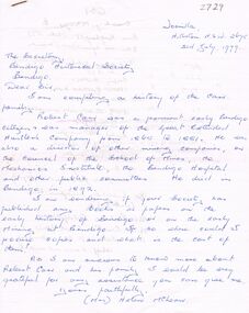
Document - ROBERT CARR: CORRESPONDENCE AND LIFE HISTORY INFORMATION
Robert Carr - correspondence to BHS and life history information sent back to writer re Carr (Great Extended Hustlers). Robert Carr was born Magherfelt Ulster 1833 and educated in agricultural pursuits. He arrived at Eaglehawk (part of Sandhurst) 4 miles from Bendigo in 1853 and began alluvial mining in 1855. Robert was on the committee to establish the Presbyterian Church at Eaglehawk. Robert began reef mining at Hustlers and Extended Hustlers mines and was manager in 1881. Robert was also a past Secretary of Oddfellows. In the years 1871-2 the mine yielded marvellous cakes of gold. He was a model mine manager. During 1872 he was on the committee of School of Mines. In the year 1873 he fell 60 feet down an abandoned shaft and not badly hurt. Robert died in May 1893, aged 60 years, and at the time of death was director of Great Extended Hustlers, Hustlers Company. 'A person of uprightness, frankness and integrity.'person, individual, robert carr, presbyterian church eaglehawk, hustlers, extended hustlers and great extended mines, oddfellows, school of mines bendigo. -
 Bendigo Historical Society Inc.
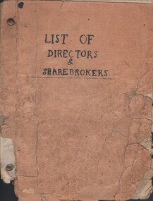
Document - MCCOLL, RANKIN AND STANISTREET COLLECTION: LIST OF DIRECTORS AND SHAREHOLDERS, 1950/61
Documents: paper bag contains - well-worn booklet 21x16cm 'List of Directors & sharebrokers' for goldmines, meeting times, reports to press, company report recipients for Monument Hill Consolidated, Central Nell Gwynne, East Clarence, New Don, South Nell Gwynne, Deborah Gold Mine, South Deborah, North Virginia, Central Deborah, North Deborah Mining, Nell Gwynne Reef, Central Napoleon, New Monument, North Hustlers, Napoleon Reef, Deborah Extended, Deborah United, South Wattle Gully Company, Red, White & Blue Extended, Golden Carshalton, poor condition, also several company change of address notices.MCCOLL RANKIN AND STANSISTREETorganization, business, gold mining - legal, mccoll rankin and stansistreet -
 Bendigo Historical Society Inc.
Document - PREMIER COMPANIES (GOLD MINING)
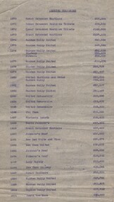
Document. 2 page typed document titled 'Premier Companies'. Lists various mining companies from 1870 to 1920 and the amount in pounds that each mine yielded. Mentions mines - Great Extended Hustlers, Great Extended Hustlers Tribute, Garden Gully United, Victory, Pandora, United Hustlers, Redan Garden Gully, United Devonshire, Old Chum, Victoria Quartz, North Johnson's, Johnson's Reef, New Red White and Blue, New Chum United, Lady Barkly, New Chum Railway, Great Southern, South New Moon, New Argus, Virginia, Central Red White and Blue, New Chum Goldfields, Victoria Consols, Carlisle, Hercules and Energetic, New Golden Fleece, Bendigo Amalgamated Goldfields.cottage, miners, premier companies (mining), bendigo mines -
 Bendigo Historical Society Inc.
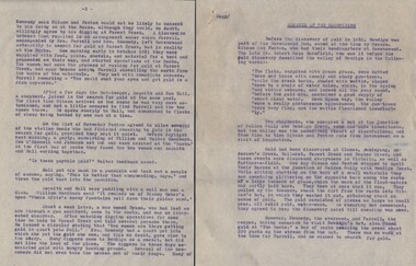
Document - ROMANCE OF THE GOLDFIELDS
Document. 8 page typed document titled 'Romance of the Goldfields'. (2 copies). 'Copy' is typed at the top of document. Mentions the gold rushes of Bendigo and Forest Creek. Mentions, Messrs. Gibson & Fenton, Mr Robert Ross Haverfield, Kennedy and Farrell, Asquith, Ben Hall, William and Walter Sandbach, Ron O'Donnell, Johnson, Bypass, Latham, Watson, Bell, Mr J B Watson, Mr George Lansell. Also mentions Gold Yields. Mentions Mines - Advance, Great Extended Hustlers, Garden Gully, New Chum, Victoria, Kent Mine, Golden Fleece, Richard Heales, Cornish United, Great Extended Hustlers, Tribute Company, Williams United, South New Moon, New Moon, Carlisle Group, Johnson's Reef, North Johnson's, Hercules and '180'. Envelope that this document was in is marked 'Notes re - Romance of Goldfields, Premier Companies, Sebastian Mining Leases, Resources of Bgo Goldfields, Sheepshead Line of Reef'.cottage, miners, romance of the goldfields, bendigo, forest creek -
 Bendigo Historical Society Inc.
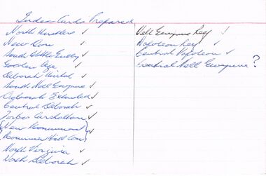
Document - SET OF INDEX CARDS - MINING
Set of Index Cards prepared (white lined) containing information on various mines - North Hustlers, New Don, South Wattle Gully, Golden Age, Deborah United, South Nell Gwynne, Deborah Extended, Central Deborah, Forbes Carshalton, New Monument, Monument Hill Consolidated, North Virginia, North Deborah, Nell Gwynne Reef, Napoleon Reef, Central Napoleon, Central Nell Gwynne. McColl, Rankin & Stanistreet Collection.topic, mining, companies -
 Bendigo Historical Society Inc.
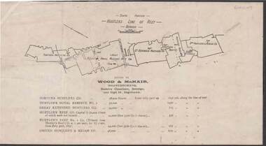
Document - KELLY AND ALLSOP COLLECTION: HUSTLERS LINE OF REEF MAP, 30/07/1891
Document. KELLY & ALLSOP COLLECTION. Map of the Hustlers Line of Reef, Bendigo (South portion). Issued by Wood & McNair, Sharebrokers, Beehive Chambers, Bendigo and High St., Eaglehawk. Mines shown on map are Fortuna Hustler's Co., Hustler's Royal Reserve No.2, Great Extended Hustlers Co., Hustlers Reef Co., Hustler's Reef No.1 Co., United Hustler's & Redan Co. Number of shares is listed against each of these mines.Wood & McNairbusiness, stockbroker, kelly & allsop, kelly & allsop collection, hustlers line of reef map, wood & mcnair. -
 Bendigo Historical Society Inc.
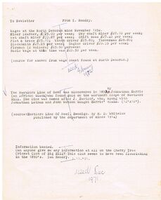
Document - WAGES AT THE NORTH DEBORAH MINE NOVEMBER 1952
Typed notes detailing the wages of various mine workers and also the Basic Wage at the time. Also mentions the discovery of the Hustlers Reef by Johnathan Harris and if anyone can give information on the Cherry Tree Cricket Club of Big Hill.document, typed notes detailing the wages of various mine workers and also the basic wage at the time. also mentions the discovery of the hustlers reef by johnathan harris and if anyone can give information on the cherry tree cricket club of big hill. typed notes detailing the wages of various mine workers and also the basic wage at the time. also mentions the discovery of the hustlers reef by johnathan harris and if anyone can give information on the cherry tree cricket club of big hill. -
 Bendigo Historical Society Inc.
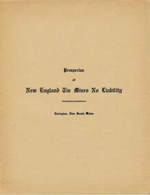
Document - MCCOLL, RANKIN AND STANISTREET COLLECTION: PROSPECTUS NEW ENGLAND TIN MINES NL, 1934
McColl Rankin & Stanistreet. A/ Prospectus New England Tin Mines NL. Contains prospectus on New England Tin Mines NL, Torington, NSW. Markings/inscriptions: Prospectus of New England Tin Mines NL' on front cover. Includes Application for Shares on loose sheet. B/ Prospectus of North Hustlers Gold Mining Company No Liability. Hustlers Reef, Eaglehawk, Bendigo. January 1940. Inscriptions/Markings: Stamp John May & Sons Stock & Share Brokers, 90 Queen St., Melbourne, stamped on front cover and inside back cover.organization, mining, north hustlers gold mining co nl, mccoll rankin & stanistreet new england tin mines nl prospectus of north hustlers gold mining company nl hustlers reef eaglehawk bendigo -
 Bendigo Historical Society Inc.
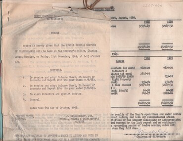
Document - MCCOLL, RANKIN AND STANISTREET COLLECTION: NORTH HUSTLERS GMC - CORRESPONDENCE FILE, 1940 - 1969
... . Application for renewal of lease for North Hustlers Mine 9.4.1950... Hustlers Mine 9.4.1950. Prospectus for Hustlers Reef. Plan ...Document. Bundle of letters, etc bound together with string. Reports for Annual General Meetings including profit & loss statements. Lists of shareholders. Proxy forms. Application for renewal of lease for North Hustlers Mine 9.4.1950. Prospectus for Hustlers Reef. Plan of residential area for application of lease.McColl, Rankin & Stanistreetorganization, business, north hustlers gmc, mccoll, rankin & stanistreet, north hustlers gmc, gold mining, lease, share holders, profit & loss, prospectus, agm -
 Bendigo Historical Society Inc.
Document - LONG GULLY HISTORY GROUP COLLECTION: HUSTLERS LINE OF REEF
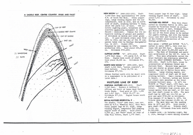
Page mentioning mines on the Hustlers Line of Reef. The are: Fortuna Hustlers, Royal Hustlers Reserve No 2 - City and Park Shafts, Great Hustlers, Latham, Watson, Great Extended Hustlers, Tribute or Pups Shaft, Bendigo's Worst Mining Disaster May 2 1914, Hustlers Reef (Old Hustlers) and Hustlers Reef No 1, Lansell's Comet Lightening Hill Line, The Old Comet (Cooper's Claim), United Hustlers and Redan, K K Shaft, North or New Hustlers (once known as Agnew Hustlers), Derby Line - Johnson's No 3, Paddy's Gully Line, Lansell's 'Sandhurst' (Needle), Needle Loops, Cleopatra Needle top, British American, Collman and Tacchi and South Virginia. Also mentioned is Total Gold Yield, Main Shafts on Field, Price of Gold (Old Currency) and Saddle Reefs and Spurs. Also mentioned are New Moon, Suffolk United, South New Moon and North New Moon. There is a diagram of a Saddle Reef, Centre Country, Spurs and Fault. Depth of shaft, machinery, location, dividends and yields are also mentioned. Price of Gold (Old Currency): 1851-1930, Price varied from Approx. £3/17/6 to £4 per ounce. 1938, from £6/19/10 to £7/8/10 per ounce. 1946/47/48 £10/15/3 per ounce, May 1, 1954 £15/12/6 per ounce.bendigo, history, long gully history group, the long gully history group - hustlers line of reef, fortuna hustlers, buckell & jeffrey's, railway goods sheds, rsl memorial hall, camp hill school, royal hustlers reserve no 2 - city and park shafts, jonathan harris, latham and watson, great hustlers, great extended hustlers, wattle gully mine, messrs j hustler latham and watson, tribute or pups shaft, bendigo's worst mining disaster, hustlers reef (old hustlers) and hustlers reef no 1, lansell's comet, the old comet (cooper's claim, united hustlers and redan, k k shaft, north or new hustlers (once known as agnew hustlers), derby line - johnson's no 3, pa ddy's gully line, lansell's 'sandhurst' (needle), needle loops, cleopatra needle top, british american, collman and tacchi, south virginia, saddle reefs and spurs, new moon, suffolk united, south new moon, north new moon -
 Bendigo Historical Society Inc.
Document - LANSELL RELATED DOCUMENTS
Document.Copy of Williamstown Historical Society Newsletter No 17 (1977).On the second and third page of this Newsletter is an article entitled ''The guns of the 'Nelson''', written by Doug Mills, Castlemaine. The Warship NELSON underwent alterations in 1860, including cut down to two decks and lengthened, her armaments reduced to 72 guns. Two 7inch 68 pounder guns were added to her armament. In February 7 1867 she was officially given to the Colony of Victoria by the Imperial Government. At the time her Commander was Captain Charles B. Payne. The Warship reached Melbourne in 4th February 1868. Relics of the NELSON were auctioned at Williamstown Victoria Naval Depot, and her two anchors are preserved for public display at Williamstown. An active demand for a share of the guns from various towns in the State. Ballarat received four (4) guns, Bendigo and Castlemaine two (2) each, while one has been given to each of the following towns: - Ararat, Tarnagulla, Hamilton, Bacchus Marsh, Echuca and Geelong. Collection of Lansell related documents: a. Copy of photograph - Lansell's Big 180 Victoria Hill - early 1870s - New Chum Hill in background. B. Lansell Estate mines - compiled from the annual report of the Hon Minister of Mines for Victoria, 1906. A listing of the George Lansell Mining Company interests at the time of his death. These were, New Moon Co, N.L., Clarence, New Prince Of Wales Co. N.L., Virginia G. M. Co., Catherine Reef United Co N.L., Great Northern Co N.L., Williams United, McDuff Amalgamated Co, South Mungo Co, South Prince Of Wales Consolidated, Constellation Co. Golden Pyke Co, Johnson's Reef Extended Company, Golden Age Co., Princess Dagmar Co, New St Mungo Co, Johnson's Reef Co, North Johnson's Co, Collman and Tacchi Co, Confidence Extended Co, G. Lansell Sandhurst Mines, Pearl Co., Windmill Hill Co., United Hustlers and Redan, Koch's Pioneer Co., Hercules and Energetic Co., Lansell's Comet, Cornish United Co., Ironbark Co., Hustler's Reef Co., and No. 1 Lansell's 83, Carlisle Co., Great Extended Hustler's Co., Victoria Consolidated Co., Great Central Victoria Co., Victoria Quartz Co., Victory and Pandora , Lansell's Big 180, Tambour Major, New Chum and Victoria Co., Garden Gully United Co., G. Lansell, Lansell's 222, Lazarus Co., Sea Amalgamated Co., Hustler's Royal Reserve Co., Horwood and Burrowe's Co., New Chum Consolidated Co., G Lansell's Sheepshead, Gariboldi Co., Londonderry Co., Shamrock Co., Great Britain Co., Fortuna Hustler's Co., Eureka Extended Co., G. Lansell's G.V.L., New Red White and Blue Consolidated, Great Southern Co., Lansell's Concord Mines, True Blue Co., G. G. Consolidated Co., Extended Red White and Blue Co., Great Columbian, Sedgwick and New Birthday. Also, a listing: ''Among the biggest yields to ate (sic) (date?) in ozs or Pounds were''; New Moon.Co. N.L. 180,087 ounces, Clarence £303,932, Catherine Reef United N.L. £762,815, Great Northern Co Ltd £394,525, Johnson's Reef Co 277,320ounces, Windmill Hill Co. 113,842ounces, Hustler's Reef Co. And No.1 1,144,923ounces, Carlisle Co 307,835ounces, Great Extended Hustlers Co £1,038,125, Garden Gully United Co. £1,653,900, Great Southern 97,752ounces, New Chum Consolidated 89,526ounces. This part (b) has handwritten inscription ''compiled by J Sarvaas MCE(??) Certified Mining Surveyor; 22/8/06''; c. Copy of Deed dated Dec 1886 between George Lansell, Wooten Lansell and the Bank of New South Wales relating to a wall and windows and openings etc etc. (3 pages of legalese!!!!!). Also, a (related?) page copy of a Grant -by purchase to the Bank of New South Wales with a date of August 1855 on it ''Enrolled in the Office of the Registrar of the Supreme Court of the Colony of Victoria - signed by Acting Registrar.document, gold, mines -
 Bendigo Historical Society Inc.
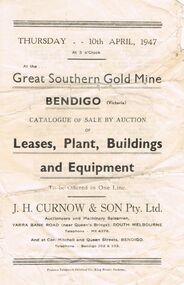
Document - IAN DYETT COLLECTION: AUCTION CATALOGUE - GREAT SOUTHERN GOLD MINE
... Fortuna Hustlers Mine Carshalton Line Red White and Blue ...Small catalogue for an auction sale at the Great Southern Gold Mine on the Garden Gully Line of Reef. Lease Nos. 11033 and 10690. Auction of Leases, Plant, Buildings and Equipment was held on 10th April 1947. J. H. Curnow & Son Pty Ltd. Were the auctioneers. Contains description of machinery and circular brick smoke stack.business, auctioneers, j h curnow & son pty ltd, ian dyett collection - auction catalogue - great southern gold mine, j h curnow & son pty ltd, prahran telegraph printing co, garden gully line of reef, fortuna hustlers mine, carshalton line, red white and blue consolidated, new chum railway, whip and jersey -
 Bendigo Historical Society Inc.
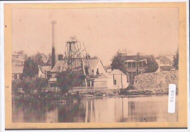
Photograph - View of Hustler's mine
... machine. HE later sold the mine to the Hustlers Reef Mining... machine. HE later sold the mine to the Hustlers Reef Mining ...Named after Thomas Hustler who purchased the lease in 1854. It was an opencut mine at this stage and Hustler patented a quartz crushing machine. HE later sold the mine to the Hustlers Reef Mining and drainage Co. and by 1865 the Great Extended Hustler's was operating 31 levels at a depth of 1053meters. The mine ceased operation in 1921.A4 copy of an original photograph, sepia toned print. View of hustler's Mine facing Barnard Street, Bendigohustler's, barnard street, james brierley -
 Bendigo Historical Society Inc.
Pamphlet - MERLE HALL COLLECTION: ROSALIND PARK CREATIVE VILLAGE BENDIGO PROJECT PAMPHLET, 1995
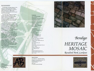
Merle Hall Collection: Rosalind Park Creative Village Bendigo Project Pamphlet for Rosalind Park Lookout - two copies. One side of the pamphlet has a layout image of the five sections of the mosaic and the poppet head base. The sections are numbers 1 to 5 Section 1: A stylised representation of the main Bendigo Goldfield based on a geological plan (Publish in 1992). It shows the lines of reef, including the famous Hustlers, Garden Gully and New Chum. Section 2: A typical cross section of the Bendigo Goldfields Section 3: The mine layout shown in this design features part of the Garden Gully line of reef. Section 4: Shown here is the Iron Bark mine on the Sheepshead reef. It has an interesting pattern of drives, stopes and winzes. Section 5: In this section the artist uses gold as her inspiration. The larger mosaic shows quartz veins winding through the earth containing gold in its various forms. The smaller mosaic represents the atomic structure of gold. It shows the the nucleus, the six shells of the atom, their electrons and orbits. The other side of the pamphlet describes the background of the community arts project, the artist, and volunteer workers, also notes mentioning the Bendigo community history. It also lists the donors for funding and business's that supported the project, with special thanks to Eric Wilkinson - Geolpogical advoser, the students and staff from Camp Hill, St Killians and Violet Street primary schools. BRIT and La Trobe University, bendigo. -
 Bendigo Historical Society Inc.
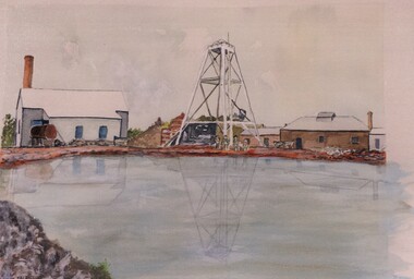
Photograph - JOHN HALL COLLECTION: PHOTO OF THE ORIGINAL WATER COLOUR PAINTING: CLARENCE MINE
JOHN HALL COLLECTION: PHOTO OF THE ORIGINAL WATER COLOUR PAINTING: Hustlers Reef Written on the rear ClarenceJohn Hallartwork, water colour, gold mines -
 Bendigo Historical Society Inc.
Photograph - JOHN HALL COLLECTION: PHOTO OF THE ORIGINAL WATER COLOUR PAINTING: HUSTLERS REEF
JOHN HALL COLLECTION: PHOTO OF THE ORIGINAL WATER COLOUR PAINTING: Hustlers Reef Written on the rear Hustlers Reef 2John Hallartwork, water colour, gold mines -
 Bendigo Historical Society Inc.
Photograph - JOHN HALL COLLECTION: PHOTO OF THE ORIGINAL WATER COLOUR PAINTING: HUSTLERS REEF NO2
JOHN HALL COLLECTION: Photo of the original WATER COLOUR Painting: HUSTLERS REEF NO2John Hallartwork, water colour, gold mines -
 Bendigo Historical Society Inc.
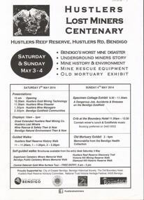
Document - GREAT EXTENDED HUSTLERS GOLD MINE: LOST MINERS FLYER FOR CENTENARY OF MINE DISASTER
On May 2nd 1914, 7 miners were killed in a dynamite explosion in the Great Extended Hustler's Gold Mine. It was Bendigo's worst mining disaster and although an inquest found it was an accident, no cause for the explosion was found.Advertising flyer for an event held on May 3-4 2014, to mark the centenary of the mine disaster that killed 7 minersat the Great Extended Hustlers mine. Other activities included a Specimen Cottage exhibit; guided walks around the Hustlers Reef Reserve; displays on site and talks by various speakers on the mine disaster and mining technology. Event was organised by the Bendigo Historical Society in conjunction with the Hustlers Reserve committee. -
 Bendigo Historical Society Inc.
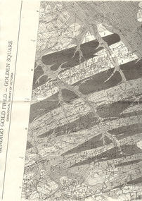
Map - LONG GULLY HISTORY GROUP COLLECTION: BENDIGO GOLD FIELD - GOLDEN SQUARE GEOLOGICAL SURVEY OF VICTORIA
BHS CollectionPart of a map of the Bendigo Gold Field - Golden Square. Geological Survey of Victoria. Shown are reefs, faults and anticlines. Many of the mines are shown on the map. Gullies, hills and streets are also shown.bendigo, history, long gully history group, the long gully history group - bendigo gold field - golden square geological survey of victoria, north bendigo state school reserve, hospital reserve, benevolent asylum reserve, empire hill, richmond hill, raes hill, south end hill, victoria hill, new chum hill, iron bark hill, redan hill, view hill, hustlers hill, camp hill -
 Bendigo Historical Society Inc.
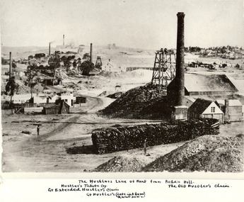
Photograph - HUSTLER'S LINE OF REEF
... BHS Collection MINE Gold hustlers reef mine Bendigo mines ...BHS CollectionBlack and white photograph of mining landscape with poppet head, chimney and mining sheds (plus timber in stack) in foreground. Other mines in bare landscape on LHS background and housing on RHS background. Inscriptions: on front - 'The Hustler's Line of Reef from Redan Hill Hustler's Tribute Coy', 'Gt. Extended Hustler;s Claim', 'The Old Hustler's Claim, Gt. Hustlers (Late Latham & Watson's). On back - 'A Richardson, 29 Harrison Street, Bendigo'.mine, gold, hustlers reef mine, bendigo, mines and mining, mine, mines, mining, landscape, mining landscape, redan hill, poppet head, old hustlers, mining cottages -
 Bendigo Historical Society Inc.
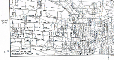
Map - LONG GULLY HISTORY GROUP COLLECTION: MAP OF REEFS AND MINES
BHS CollectionTwo pages with lines of reef and mines from Spring Gully Reservoir to north of the Eaglehawk Railway Station. Shown on the map are the lines of reef, the Thistle, Carshalton, Napoleon, British & Foreign, Nell Gwynne, New Chum, Sheepshead, Deborah, Garden Gully, Paddy's Gully, Derby, Miller's, Hustlers, Lightning Hill, Myers Flat, Lancashire, Cook's, Maiden Gully, Johnson's and Millers. Also shown are the Golden Square, Bendigo and Eaglehawk Railway Stations as well as the hills.bendigo, history, long gully history group, the long gully history group - map of reefs and mines, spring gully reservoir, thistle, carshalton, napoleon, british & foreign, nell gwynne, new chum, sheepshead, deborah, garden gully, paddy's gully, derby, miller's, hustlers, lightning hill, myers flat, lancashire, cook's, maiden gully, johnson's, millers, golden square railway station, bendigo railway station, eaglehawk railway station -
 Bendigo Historical Society Inc.
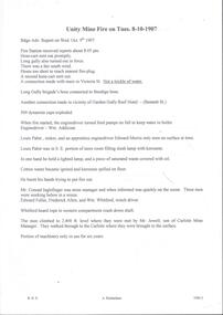
Document - ULSTER GOLD MINING COMPANY NO LIABILITY - UNITY MINE FIRE 8/10/1907 & FAMOUS GOLD MINES
Typed copy of recount by Albert Richardson of a fire at Unity Mine on Tuesday 8-10-1907. Report from the Bendigo Advertiser Wednesday October 9th 1907. Notes mention Fire Brigade, miners, how the fire started and how the men down the shaft escaped when the rope crash down the shaft. On the back is a handwritten carbon copy of notes titled Famous Gold Mines of Bendigo and Eaglehawk. Notes give yields of gold for alluvial and quartz mining. Deep Shafts in 1904 of which there were eleven with a depth of more than 3000 feet and 53 over 2000 feet and two which were more than 4000 feet. Wages for 1911 for Engine Drivers and Firemen and Boiler Attendants. Note on winding plants and air compressors.document, gold, ulster gold mining coy no liability, ulster gold mining company no liability, unity mine fire 8/10/1907, bendigo advertiser 9/10/1907, garden gully reef hotel, wm addicoat, louis pabst, edward morris, conrad inglefinger, edward fuller, frederick allen, wm whitford, mr jewell, carlisle mine, famous gold mines of bendigo and eaglehawk, new chum line, garden gully line, hustlers line, victoria quartz mine, new chum railway, mines report 1911 p15, albert richardson -
 Bendigo Historical Society Inc.
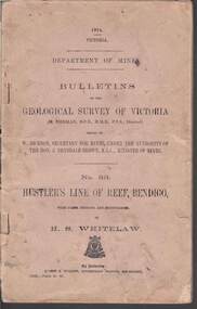
Book - STRUGNELL COLLECTION: DEPARTMENT OF MINES: 1914 GEOLOGICAL SURVEY OF VICTORIA. HUSTLERS LINE OF REEF, 1914
Book, Department of Mines, Bulletins of the Geological Survey of Victoria, No.33, Hustler's Line Of Reef, Bendigo, with plans,sections, and photographs, by H.S.Whitelaw. 13833, Price 2s.6d.`Back cover shows J.A. and J.A Strugnell , 12 Mulbar St Swan Hill 3585 .Albert J. Mullett, Government Printer, Melbourne.book, bendigo, hustler's line of reef -
 Bendigo Historical Society Inc.
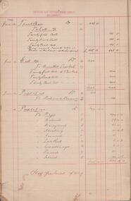
Administrative record - Catherine Reef Extended Mining Co. and Kingsley's Reward Mining Co. journal, 1919 - 1920
Maroon soft cover book. Inside front cover 'Journal' printed in black pencil. Six pages of financial records entries for Catherine Reef Extended Mining Co. dating from December 12th, 1905 to 17th April, 1911. One page of financial records for Kingsleys Reward Mining Co. N.L., showing unalloted shares, uncalled capital and mine account . Mine Manager's book forms part of the Margaret Roberts Collection of Mining records.bendigo, margaret roberts, legal managers, mine manager, east moon gold mining company n.l., e.g. robertson mine manager, alfred jorgensen contractor, paddy's gully shaft, derby shaft, hustler's shaft, -
 Bendigo Historical Society Inc.
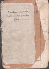
Booklet - Albert Richardson Collection: Bendigo Goldfield, MInes Department, Victoria 1936, 1936
Albert Richardson was an expert on the history of the Bendigo Goldfield. The Albert Richardson Park at Victoria Hill, is named in his honour. He was a prominent member of the Bendigo Historical Society. Fifty one page booklet. On front page: Bendigo Goldfield, issued by Geo Brown, Secretary for Mines, under the authority of The Hon. E.J. Hogan, M.L.A., Minister of Mines. Mines Department, Melbourne, Victoria, Australia, 1936.Content includes: historical information; recent development and future prospects, geology and lines of reef. Reef lines described are: Tysons, Lightning Hill, Hustlers, Derby, Paddy's Gully, Garden Gully, Deborah, Sheepshead, New Chum, Nell Gwynne, British and Foreign, Napoleon, Lancashire, Carshalton, Thistle, Christmas and Birds. On front cover 'Bendigo Goldfield, Geo Brown, Sec. for Mines, 1936' written in black pen. On first page 'A.Richardson, 29 Harrison Street, Bendigo' The booklet is annotated throughout by Albert Richardson, for example, the mines along the New Chum Line are further described with their date of formation, sill heights and area of claim.albert richardson, gold mining, goldfield, reef lines, 1936