Showing 174 items matching "information technology"
-
 The Beechworth Burke Museum
Photograph - Photograph - Reproduction
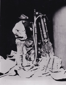
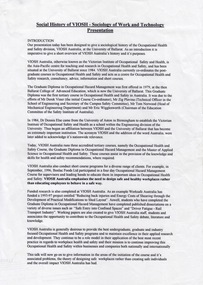
... in mining can reveal important information for technology ...This photo depicts a man standing next to a large piece of mining equipment identified as a hydraulic chisel (alternative name: drifter dill or power rock drill). This piece of machinery was used in mining to place holes in the walls of a mine which were then filled with dynamite or other explosives for rock blasting or to make holes for plug and feather quarrying. The additional tools to the right of the photograph and in front of the machinery can be identified as either picks or as feather and wedges, the latter of which were used to split stone drilled by the hydraulic or power chisel. Depending on the date of the photograph, which is not provided, this chisel was either powered by electricity or by hydraulics. The following is written on the drill "R.C. FORD'S PATENT No91 / MELBOURNE VICTORIA 1879". The man depicted in this photograph wears a wide brim hat, a loose fitting white shirt and loose pants. He wears boots and has a medium sized dark beard. This attire, along with his locality in the mine and proficiency with the mining equipment, identifies this man as a miner working in this particular, but unidentified, mine. It depicts an instance of hydraulic chiseling which makes this photograph valuable for the study of mining techniques from a date c1880.The search for gold is ingrained into the history of Victoria and therefore, images like this one which portray the types of machinery used in mining can reveal important information for technology and highlight the methods used to break apart the earth in order to obtain access to gold and other precious materials during the period this photograph was captured. Further research into RC Ford can potentially reveal even further information pertaining to this photograph. This image is of important historical significance for its ability to convey information about the methods and machinery used to access gold or mine more in general. It also highlights the size of machinery at the time and allows us to compare this to the size of the person standing besides the machinery to better understand the manpower which would have been required to use and set-up this macinery.A black and white rectangular reproduced photograph printed on matte photographic paper.Reverse: 7816/ copy 1/3gold, sluicing, gold sluicing, hydraulic sluicing, gold and tin mine, mining, gold mining, beechworth, burke museum, melbourne, victoria, hat, mining machinery, machinery, r. c. ford -
 The Beechworth Burke Museum
Photograph - Photograph - Reproduction
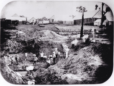
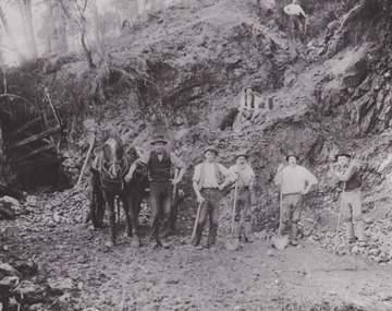
... '. Claims such as this utilised a range of technology, including ...After gold was discovered to be deposited "for miles along Woolshed Valley" in the early 1850s, the Woolshed became a major site of mining activity in the north-east . This region was divided into large claims of 80 yards long, one of which was the one depicted in this photograph, called 'Big Johnson's Claim'. Claims such as this utilised a range of technology, including water wheels, steam engines, sluices and toms, most of which would not arrive until after 1856 when this photograph was taken. The Woolshed initially became prosperous in 1855, and labourers, such as the ones depicted in this photograph, engaged in sinking work for 7 pounds a week, whilst other mining labourers could earn up to nine. The search for gold is ingrained into the history of Victoria and therefore, images like this one which portray an open cut sluicing site can reveal important information for society and technology for the date when the photograph was taken. This image is of important historical significance for its ability to convey information about the operations of mining claims, particularly of the Woolshed Valley area that this photograph documents. This image is important for current research into the history of Woolshed, which was a major site of mining significance and operations. Therefore, this image has the capacity to be beneficial for research into society and the motivations of those living and working in this region during this period and therefore, has social significance. The Beechworth Burke Museum has additional images relating to gold sluicing and the Woolshed area which can be analysed and studied alongside images like this one. A black and white rectangular photograph printed on matte photographic paper.Reverse: 7791 / page 34. / 52% / Big Johnstone / Claim on Woolshed Goldfields / 1856 / Note canvas [illegible] building / Burke Museum /woolshed, mining, claims, mining claims, big johnson, gold -
 The Beechworth Burke Museum
Photograph - Photograph - Reproduction
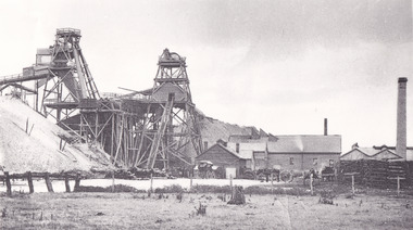
... of a range of modern technologies, including the hydraulic pumps ...This photograph depicts the Great Southern Mine located in Rutherglen as it was during the 1900. After the initial Gold Rush of 1853-1854, Gold was discovered deeper under the surface of the earth in the 1860 after the discovery of another deep lead system. Due to the discovery of Gold in Rutherglen, Rutherglen developed into a community in its own right, possessing a population of 6600 by December 1860 and developed into a municipality in 1862. The Great Southern Mine depicted in this photograph required the use of a range of modern technologies, including the hydraulic pumps, in order to reach gold. This photo depicts the mining operations as they were undertaken around the turn of the century.The search for gold is ingrained into the history of Victoria and therefore, images like this one which portray a modern mining operation undertaken in the 1860s, can reveal important information for society and technology for the date when the photograph was taken. This image is of important historical significance for its ability to convey information about the methods used to extract gold in 1900. It is significant as most mining operations around the region, particularly earlier on in the period, used different technologies such as water races. This image is important for current research into the history of Rutherglen more generally, a town which developed singlehandedly due to the discovery of minerals and mining, as depicted here in this photograph, thus indicating an element of social significance as well as historic. The Beechworth Burke Museum has additional images relating to mining and Rutherglen which can be analysed and studied alongside images like this one.A black and white rectangular photograph printed on matte photographic paper.Reverse: $ 3.00 19972503 / a02503 / Great Southern Mine Rutherglen 1900rutherglen mine, rutherglen, great southern mine, beechworth, mine, mining, post goldrush, victoria, gold, 1860s, sluicing, hydrolic sluicing -
 The Beechworth Burke Museum
Photograph
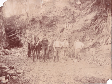
... important information for society and technology for the date when ...This photograph depicts a reef mine in Beechworth. Reef mining, or quartz reef mining, was common in 19th Century Victoria. This gold mining technique requires mine shafts to be sunk into underground quartz reefs, with horizontal tunnels dug from the original shaft at differing levels to find the gold-bearing rock. The quartz would then be hoisted to the surface, which would then be pounded to access the gold in its metallic state. Gold was discovered in Beechworth in February 1852, at Spring Creek. Within 11 months of that discovery, over 8000 hopeful prospectors quickly descended on this region, transforming it into a thriving, wealthy township. Reef mining and hydraulic sluicing were gold mining techniques used in this region in the 19th and early 20th centuries. This photograph interestingly contains dogs alongside the miners. While dogs have been recorded as deterrents to thieves in the Victorian goldfields, these dogs appear as companions to these men.The search for gold is ingrained into the history of Victoria and therefore, images like this one can reveal important information for society and technology for the date when the photograph was taken. It also shows a location where reef mining was undertaken which provides insight into the impact on the environment at a time when it was done. Although quartz is one of the most common minerals found in the earth's crust, it does not always contain gold. Those reefs that do are rare and highly sought after by prospectors. The Beechworth Burke Museum has additional images relating to gold mining which can be analysed and studied alongside images like this one.Sepia coloured rectangular photograph printed on gloss photographic paper. Obverse: Reverse: United Shire of Beechworth/ Shire Secretary/ Reef Mining, Beechworth./ 6167.abeechworth, burke museum, gold, gold mining, gold rush, victorian gold rush, reef mining, quartz, companion dog, horse and cart -
 The Beechworth Burke Museum
Photograph - Photograph - Reproduction
... and therefore, images like this one can reveal important information ...This reproduced photograph depicts a reef mine in Beechworth. Reef mining, or quartz reef mining, was common in 19th Century Victoria. This gold mining technique requires mine shafts to be sunk into underground quartz reefs, with horizontal tunnels dug from the original shaft at differing levels to find the gold-bearing rock. The quartz would then be hoisted to the surface, which would then be pounded to access the gold in its metallic state. Gold was discovered in Beechworth in February 1852, at Spring Creek. 8000 hopeful prospectors quickly descended on this region within the year, transforming it into a thriving, wealthy township. Reef mining and hydraulic sluicing were gold mining techniques used in this region in the 19th and early 20th centuries. This reproduction photograph interestingly contains dogs alongside the miners. While dogs have been recorded as deterrents to thieves in the Victorian goldfields, these dogs appear as companions to these men.The search for gold is ingrained into the history of Victoria and therefore, images like this one can reveal important information for society and technology for the date when the photograph was taken. It also shows a location where reef mining was undertaken which provides insight into the impact on the environment at a time when it was done. The Beechworth Burke Museum has additional images relating to gold mining which can be analysed and studied alongside images like this one.Black and white rectangular reproduction photograph on gloss photographic paper. Obverse: Reverse: L is miners 26%/ 10 x 8/ 6167.bbeechworth, burke museum, gold, gold mining, gold rush, victorian gold rush, reef mining, quartz, companion dog, horse and cart -
 The Beechworth Burke Museum
Postcard, 1914-1916
... and therefore, images like this one can reveal important information ...This postcard shows a group of men standing outside of the Everton mine alongside a mining trolley sitting on tracks. The search for gold is ingrained into the history of Victoria and therefore, images like this one can reveal important information for society and technology for the date when the photograph was taken. It also shows a location where reef mining was undertaken which provides insight into the impact on the environment at a time when it was done.A sepia toned rectangular postcard printed on photographic paperpost card/correspondence address only/ Kodak Australia/1914everton mine, mining, goldrush, postcard, burke museum, black and white, photograph, mining trolley -
 The Beechworth Burke Museum
Photograph, unknown
... reveal important information for society and technology ...This reproduced photograph is of Pennyweight Flat near Beechworth, a notable area of the 1850's gold rush in Victoria. Donald Fletcher, migrating to Beechworth from Scotland in 1855, had substantial claims at Pennyweight Flat and was amongst the first in the district to utilise hydraulic sluicing and water diverting methods.The flat is said to have seen a flurry of 200 miners to the area around 1857, and by 1861 when work commenced on extending Fletcher's tail race the census recorded 644 people residing there (European males, females and Chinese). Pennyweight Flat is also significant for the cemetery that resides on the hilltop and which noted approximately 200 burials from the gold rush period 1852-1857, known for a long period as a children's cemetery due to the number of children's graves present.The search for gold is ingrained into the history of Victoria and therefore, images like this one which portray an open cut sluicing site can reveal important information for society and technology for the date when the photograph was taken. This image is of important historical significance for its ability to convey information about sluicing and the methods used to find gold in 1910. It also shows a location where sluicing was undertaken which provides insight into the impact of sluicing on the environment at a time when it was done. This image is important for current research into the history of Beechworth and surrounding area including Victoria's North East. The Rocky Mountain Extended Gold Sluicing Company was a long running and very active mine that was one of the most successful and largest in the district. Therefore, this image has the capacity to be beneficial for research into society and the motivations of those living and working in this region during this period and therefore, has social significance. The Beechworth Burke Museum has additional images relating to gold sluicing which can be analysed and studied alongside images like this one. When the mine closed in 1921, in a liquidation sale, Zwar purchased the tunnel and clear water supply that ran under the town of Beechworth. He directed the water to his tannery and over time built a major industry in leather works that was a major employer in Beechworth. In growing his leather business, Zwar installed crude oil engines for electricity in his factory. He oversaw working with local council to introduce electricity to Beechworth via a sub-station on Albert Street. In 1927 Electric street lamps replaced gas lamps in the streets of Beechworth. Black and white rectangular reproduced photograph printed on glossy photographic paperObverse: Reverse: 84.222.5/ digital print/ rocky mountain extended gold sluicing company, gold, sluicing, gold sluicing, hydraulic sluicing, gold mine, open cut mining, mining, gold mining, north-east victoria, beechworth, burke museum -
 The Beechworth Burke Museum
Photograph
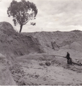
... portray an open cut sluicing site can reveal important information ...This image shows an unknown location in the area of Beechworth that was possibly used as a sluicing mining site for gold during the Victorian Gold Rush. This era saw an influx of Chinese immigrants and Australian prospectors hoping to strike it rich on the fields. Many companies such as the Rocky Mountain Extended Gold Sluicing Company Ltd and the Cocks Pioneer Gold &Tin Sluicing Company also set up mines in the area. This site may be the location of one of these company's mines. The wooden logs are reminiscent of known sluicing operations in the era from that time. Sluicing involved the use of high-pressured hoses to clear away soil from earth that had been dug up by miners and was a popular method of excavation in the area, although it had severe impacts on the environment.The search for gold is ingrained into the history of Victoria and therefore, images like this one which portray an open cut sluicing site can reveal important information for society and technology for the date when the photograph was taken. This image is of important historical significance for its ability to convey information about sluicing and the methods used to find gold. It also shows a location where sluicing was undertook which provides insight into the impact of sluicing on the environment at a time when it was done.A colour rectangular photograph printed on glossy photographic paperReverse: 6855 /beechworth, gold rush, sluicing, mining -
 The Beechworth Burke Museum
Postcard, George Symons, c.1990
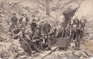
The photograph printed on this postcard comes from the collection of the Mitchell Library in Sydney. It is sepia in tone and depicts seven men standing and sitting around a mine shaft in the Beechworth region. The photograph has been dated to approximately 1872. This period in history post-dates the Victorian gold rushes which occurred 1852-1853 in Ballarat, Bendigo and Beechworth. During this period, in the 1870s, the surface alluvial gold had been discovered and removed from location. Therefore, in order to reach the deeper and less accessible alluvial gold, diggers began to dig shafts into the earth. These shafts sunk below the ground level by 20 to 30 feet and required timber structures around the entrance and winches to bring the paydirt to the top. The top of this wooden structure is visible behind the man standing in the upper right of the image. This type of mining was highly dangerous as mines often caved in which injured the minors and often resulted in death. Thus, following this period, in the early 1900s, miners opted instead for hydrolic slucing which cut away the earth without the devastating consequences of a mine cave in. This particular group of miners appear to have been unable to afford a horse (then worth around 50 pounds) which were generally used at mines like this to help pull buckets attached to ropes up and down the mine. Instead, this group brought the buckets up and down by windlass. The windlass was a wooden structure mounted over the mining shaft and fitted with a hand-cranked winch which enabled the bucket attached to the rope to be brought up and down.Gold was first discovered in Beechworth in Spring and Reid's Creek in the summer of 1852-1853. At its popularity, this region had approximately 8000 people on the gold fields searching for gold on the banks of these creeks. These periods did not require the use of heavy machinery or the digging of deep mining shafts like the one depicted in this image. Therefore, this image has important connotations for the technologies associated with mining during the approximated 1870s when gold was harder to access. This is a later period in gold history which does not fit into the "gold rush" period. Instead, it occurred after the surface gold had disappeared and therefore, is essential for researchers who are investigating the mining techniques and structures used to reach the alluvial gold which was located deeper under ground in the 1870s. This period predates the use of big heavy machinery used to mine in the 1900s which include dredges. Images such as this one can also impart essential information as to the wardrobe and fashion of men during this period. It also imparts knowledge about the landscape of Beechworth which is useful for people researching the environment and impact of gold mining in the north-east region of Victoria. In addition, since this image is a postcard reproduction of an early Australian image which may date to approximately 1990 it can impart knowledge as to the interests of people during this time period when there may have been an increase into Australian history.A sepia tone facsimile of an early Australian photograph (circa 1872) printed as a postcard.Obverse: BEECHWORTH / Victoria, Australia / Reverse: GM 2 3275 / CORRESPONDENCE / AUSTRALIAN / YESTERYEAR / CARDS / ADDRESS / Published by George Symons (057) 65 3240 / THE MINEHEAD C. 1872 / The easily gleaned gold of the early fields did / not last very long. In order to reach less / accessible alluvial gold diggers began sinking shafts as much as twenty to thirty feet down / and the mines required timbering and winches / to bring the paydirt to the top. / This syndicate has been unable to afford the / luxury of a horse (about 50 pounds) and so everything / must go up and down by windlass and rawhide / bucket. / Photo: Mitchell Library, Sydney / A sepia tone facsimile of / an early Australian photographmining album, gold mine, beechworth, burke museum, mine shaft, postcard, australian yesteryear cards, george symons, the minehead, gold fields, alluvial gold, early australia, c.1872, 1872, gold diggers, north east victoria -
 The Beechworth Burke Museum
Photograph, Walter William McLean Thwaites, c.1870
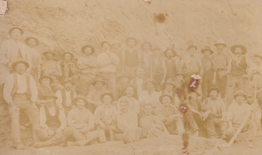
This photograph depicts a large group of men in their work clothing situated in front of a large bank of earth. They are identified as miners working in an unidentified location in Australia. This photograph was taken by photographer Walter Thwaites sometime during the period of 1865-1908, likely c.1870. It is unsure where this image was taken since Thwaites travelled a lot over his photography career and the photograph is not annotated with this information. In addition, the identities of the men in the photograph are also unknown. These men are photographed in front of a large bank of earth where they had presumably been mining for gold or other precious metals. The men, with the exception of four, are wearing wide brimmed hats to protect their faces from the sun. They are also wearing loose fitting white shirts which are often worn beneath a darker coloured vest. They wear pale coloured work pants and boots. The men are mostly clean shaven with the exception of the moustache and a couple of beards. Two of the men have pipes in their mouth. Their clothing is basic and much less dramatic than the outfits worn by the gold diggers of the 1852 gold rush. These men, by wearing similar outfits, are expressing a sense of comradery or equality between them. It is likely that they are from the same, or similar, social status. They have an air of independence and share social equality in their stance and clothing. Walter William McLean Thwaites (1840-1908) was a professional photographer born in Sydney, Australia. He learnt the craft in his father's Hobart studio, but later embarked on his own solo career and toured every existing Australian colony between 1860 to 1888. The Thwaites family were a long line of photographers and artists with Thwaites' father Walter WIlliam Thwaites Sr working as an artist and photographer in Australia after moving from England in 1834. Walter Thwaites Sr's father, also named Walter Thwaites, was a British miniature portrait artist.Images, like this one, of Australian gold rush history can reveal important information about the social and environmental impact of this period. This image depicts over 30 diggers standing in front of a bank of earth and therefore, this image has the capacity to reveal or support significant information for researchers studying the fashion and social status of diggers in Australia in approximately 1870. It can also provide information on the landscape of Australia in this period and the impact of mining for gold on both society and the Australian landscape. The Burke Museum is home to a substantial collection of Australian mining photographs which can be used to gain a deeper understanding into life on the gold fields, technology used in mining, the miners themselves and the impact of the gold digging on the environment.Sepia toned rectangular photograph printed on matte photographic paper and mounted on board.Reverse: 1997.208 / MINERS. / W. Thwaites / Photography /australia, australian photography, photography, miners, gold rush, australian landscape, diggers, walter thwaites, thwaites photography, w. thwaites photography, social history -
 The Beechworth Burke Museum
Photograph
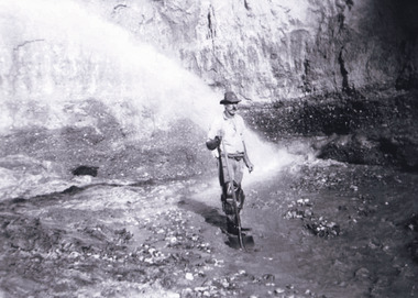
This photograph depicts a man in dark clothing, standing in front of a cut away section of earth. He is undertaking hydraulic sluicing, which involves the use of high powered hoses, in order to cut away the earth which can then be sifted for gold. There is a single tree in the background and the earth contains numerous signs of damage because of the mining. Beechworth become a mining settlement after the discovery of gold in 1852. Gold fever had already spread across Australia's colonies and the American states. Sluicing the landscape for gold, as shown in this photograph, was done by diverting water and washing away the lighter dirt, allowing the gold particles to sift down in to catchments for collection. In Beechworth, there was considerable discontent caused by attempts to restrict water use for sluicing to those with certain 'water rights'. The extensive use of hydraulic sluicing, and the washing away of top soils has continued to impact the surrounds of Beechworth in to the present day. Sluicing as a method for gold mining which was widespread across Victoria during the 1870s. The erosion of the top soil in search of gold has a continuing environmental impact on the landscape and this photograph depicts but one example of this occurring and can provide much information to a researcher interested in understanding the history of gold mining in Victoria. This image of the miner and hose is historically important because it demonstrates the methods of goldmining employed in the later years of the goldrush at Beechworth. It shows how much land is washed away by the use of this technology. The image has good interpretive capacity because it allows researchers to see a different mining technique to what is usually presented. Black and white square photograph on card.reverse: 84-50-3 / 1997 3141 / smdsluicing, goldmining, beechworth, burke museum, miners, gold miners, gold sluicing, environmental impact -
 The Beechworth Burke Museum
Photograph - Photograph - Reproduction, c1920
... site can reveal important information for society ...This photograph depicts mining operations (in particular, hydrolic sluicing) at Three Mile Mine, Barramutha, during the later periods of mining, 1920s-1950s. Three Mile Mine was a major site of mining activity sating back to the 1850s, although was often not as prosperous as other sites such as those situated on the Woolshed Valley. Many miners would leave Three Mile Mine for better prospects on other claims. The main, most successful 'rush' at Three Mile Mine occurred during and immediately following September 1855. This photograph, however, depicts a much later period.The search for gold is ingrained into the history of Victoria and therefore, images like this one which portray a miner at a sluicing site can reveal important information for society and technology for the date when the photograph was taken. This image, and its related images, it important for its historical significant of labour and mining extraction used for gold during the latter gold rushes in the 1900s. The Beechworth Burke Museum has additional images relating to gold mining in the region which can be analysed and studied alongside images like this one.A black and white rectangular photograph printed on matte photographic paperreverse: 7597.4 / copied from original on loan from Webb (Qld) / Donated Nov 2009 / Baarmutha Three Mile Mine 1920-1950 / Owned by Plain Bros then Parkinsons / John Weir or Jack Cox / Sluicing /mining, barramutha, three mile mine, sluicing, mine, beechworth -
 The Beechworth Burke Museum
Photograph
... site can reveal important information for society ...This photograph depicts four men standing near a large unidentified building. This building is the entrance to a deep lead mine shaft. There is a bridge entering the building, which was used to access the elevator to the shaft. Deep lead mining involved placing large shafts into the ground which miners use to access deeper locations in order to excavate the rocks in the search for lead. Deep lead mining was highly dangerous as roofs could cave in of the soil was loose. Therefore, this particular mining considered to be highly undesirable profession as many miners did not want to work long hours nor risk their lives in the search for lead. Indigo Shire was a large area where deep lead mining took place, and thus the landscape and environment was largely impacted by these mining businesses. The Indigo Shire grew in population and wealth in the early 1850s when people came into this location in the hopes of finding gold and making a fortune. Ultimately, the accessibility and availability of gold and precious metals decreased once the gold reserves dried up and alongside this, the large population moved away. The Ovens was also heavily impacted environmentally as deep mining resulted in the change in land formation.The search for gold is ingrained into the history of Victoria and therefore, images like this one which portray an open cut sluicing site can reveal important information for society and technology for the date when the photograph was taken. This image is of important historical significance for its ability to convey information about the methods used to find gold in Indigo Shire. It also shows a location where deep mining was undertook which provides insight into the impact of deep mining on the environment at a time when it was done. This image is important for current research into the history of Indigo Shire, a region in Victoria's north-east. Therefore, this image has the capacity to be beneficial for research into society and the motivations of those living and working in this region during this period and therefore, has social significance. The Beechworth Burke Museum has additional images relating to deep lead mining and Indigo Shire which can be analysed and studied alongside images like this one.Sepia coloured retangular photo printed on gloss photographic paper.Reverse: 1997, 2510/ A02570/ Deep Lead Mining/ page 94/ 65%/ Burke Museum, Photo 44beechworth, burke museum, indigo shire, deep lead mining, mining, gold, gold mining -
 The Beechworth Burke Museum
Photograph
... portray an open cut sluicing site can reveal important information ...This photograph dating between the 1850s and early 1900s depicts an open cut sluicing site located in Allan's Flat looking upon the open cut from Staghorn Flat Number 1. Sluicing was undertaken in the area from 1850 to 1904. The image depicts a location mined by Yackandandah Sluicing Co. It portrays and open space with pipes laying on the ground and connected to pipes leaving the barge. These pipes were used to wash and seperate the qaurtz. There are two small buildings on high ground over looking the barge. Yackandandah Sluicing Co. was created by J.A. Wallace in the 1880s. The Yackandandah Sluicing Co. operated from the mid-1880s to the early 1900s, when resources eventually ran out. Open cut sluicing involved the use of high-powered hoses which used the centrifugal sand pump system (known as hydraulic sluicing) which broke down the soil which was then processed for quartz, gold and other materials. After the resources where drained, Wallace reaped the benefits of his mining business. Allan's Flat is located on the Yackandandah Creek, and is 10km north-east of Yackandandah and 20km south of Wodonga in Victoria's regional north-east. Allan's Flat was initially used to mine gold through alluvial methods, however that came to an end with little results. The mining business was then revived by J.A. Wallace with the introduction of hydraulic sluicing.The search for gold is ingrained into the history of Victoria and therefore, images like this one which portray an open cut sluicing site can reveal important information for society and technology for the date when the photograph was taken. This image is of important historical significance for its ability to convey information about sluicing and the methods used to find gold and other minerals in the lat 19th Century. It also shows a location where sluicing was undertook which provides insight into the impact of sluicing on the environment at a time when it was done. This image is important for current research into the history of Allan's Flat, a small regional location near Yackandandah in Victoria's North East. Therefore, this image has the capacity to be beneficial for research into society and the motivations of those living and working in this region during this period and therefore, has social significance. The Beechworth Burke Museum has additional images relating to gold sluicing and Allan's Flat which can be analysed and studied alongside images like this one.Sepia coloured retangular photograph printed on gloss photographic paper mounted on board.Revers: Sluicing at Allan's Fortallan's flat, north east gold, sluicing, gold sluicing, hydraulic sluicing, mining, gold and quartz mine, beechworth, burke museum, yackandandah -
 The Beechworth Burke Museum
Photograph, Late 1900s
... important information for society and technology for the date when ...This photograph dating to the late 1900s depicts the entrance to a reef mine the in Beechworth division. The image depicts two men outside the entrance, which is covered by a hut, where one is standing near a mine cart. The mine car was used to haul soil from the mine. The Beewchworth divison consisted of 5 locations: Beechworth, Stanley, El Dorado, Hurdle Flat and Stony Creek. These locations were set up due to speculative fever that more gold could be found. In places such as El Dorado, Beechworth and Stanley there was profit, however Hurdle Flat and Stonry Creek, gold could not be found in the quantities that was required. By 1880 the Beechworth division was in depression due to the reserves being used up. However, in spite of the depression mining was continued until the late 20th Century.The search for gold is ingrained into the history of Victoria and therefore, images like this one which portray an open cut sluicing site can reveal important information for society and technology for the date when the photograph was taken. This image is of important historical significance for its ability to convey information about reef mining in the late 1900s. It also shows a location where reef mining was undertook which provides insight into the impact of reef mining on the environment at a time when it was done. This image is important for current research into the history of Beechworth , a town in Victoria's north-east. Therefore, this image has the capacity to be beneficial for research into society and the motivations of those living and working in this region during this period and therefore, has social significance. The Beechworth Burke Museum has additional images relating to reef mining and Beechworth which can be analysed and studied alongside images like this one.Sepia coloured retangular photograph printed on newspaper.Reverse: 7813beechworth, beechworth division, mining, reef mining, gold, gold mining, 1990 -
 The Beechworth Burke Museum
Photograph, 1907-8
... portray an open cut sluicing site can reveal important information ...The photo from 1907-8 is a sepia print, depicting a small valley with building at base. There are flumes visible above areas of water, trees on hills and a few small cottages on the hillside. Cock's Pioneer Gold & Tin Sluicing Co NZ No 2 Site. The photo was taken of Matthews Gully looking west. Sluicing was undertaken in the area from 1900 to 1942 with some short breaks between these periods. The image depicts a location mined by Cocks Pioneer Gold and Tin Sluicing Company (as recorded on the annotation on the card mount) The Cocks Pioneer Gold and Tin Mines N.L was one of El Dorado's two largest open cut sluicing mines of the 20th Century. The other was named the Cocks El Dorado Gold Dredging Company. The Cocks Pioneer Mines operated from 1901 until 1941 and found a total of 117,378 ounces of Gold and 1,673 tones of tin concentrates over these years. The Cocks company was formed in 1898 and operated until 1941. Open cut sluicing involved the use of high-powered hoses which used the centrifugal sand pump system (known as hydraulic sluicing) which broke down the soil which was then processed for gold and other precious metals. From 1914 , four years after this image was captured, the company reformed to Cocks Pioneer Gold and Tin Mines NL (previously it was known as Cocks Pioneer Sluicing Co) and undertook large scale sluicing operations until 1929 and then 1934-1941. El Dorado is located on Reedy Creek and is surrounded by forested country to the north and east. It is 20 km east of Wangaratta in Victoria's regional north-east. John Cock was the son of a Cornish minor who arrived in El Dorado in 1858. Cock founded his gold and tin mining company which ran successfully for many years in the El Dorado region. It was an open cut sluicing company because of the abandonment of underground mining after this was deemed too dangerous. In 1935 Cock's El Dorado Company commissioned the floating dredge which is still visible in El Dorado today. The dredge was built by the Thompson engineering works, Castlemaine, and weighed over 2,000 tones and today has a place on the Victorian Registers of historic buildings. Interestingly, the name El Dorado does not derive from the gold in the region, but from the Barambogie pastoral run completed by William Baker in 1840-1841. Gold was discovered in El Dorado 1854 but the gold was too deep for individual prospectors to find, it required the use of heavy machinery.The search for gold is ingrained into the history of Victoria and therefore, images like this one which portray an open cut sluicing site can reveal important information for society and technology for the date when the photograph was taken. This image is of important historical significance for its ability to convey information about sluicing and the methods used to find gold in 1910. It also shows a location where sluicing was undertook which provides insight into the impact of sluicing on the environment at a time when it was done. This image is important for current research into the history of El Dorado, a small regional location near Wangaratta in Victoria's North East. Therefore, this image has the capacity to be beneficial for research into society and the motivations of those living and working in this region during this period and therefore, has social significance. The Beechworth Burke Museum has additional images relating to gold sluicing and El Dorado which can be analysed and studied alongside images like this one.Sepia coloured rectangle photograph printed on gloss photographic paper Reverse: 1997. 2613/ A02613/ No2 site/ Matthews Gully/ Cocks Pioneer G&T. ?? Co NZ/ No2 Site looking West/ 1907-8/ (7)sluicing, hydraulic sluicing, 1907, 1908, mining, cock's pioneer gold & tin sluicing co nz, nz, site no 2, matthews gully, west, valley, building, cottages, hillside, trees, water, gold and tin mine -
 The Beechworth Burke Museum
Photograph, 1910 - 1911
... important information for society and technology for the date when ...This photograph depicts Cock's Pioneer G & T Sluicing site No. 4 in El Dorado. Looking eastwards, the photo captures a wooden and tin building with various mining equipment strewn in the foreground. Underneath the verandah, figures can be seen. These are believed to be a Mr. Hollister (left), Mrs. Breustedt (4th from left), children Min and Chris Breustedt, and Kate Timmons holding a girl's hand. The Cocks Pioneer Gold and Tin Mines N.L was one of El Dorado's two largest open-cut sluicing mines of the 20th Century. The other was named the Cocks El Dorado Gold Dredging Company. The Cocks Pioneer Mines operated from 1901 until 1941 and found a total of 117,378 ounces of Gold and 1,673 tones of tin concentrates over these years. The Cocks company was formed in 1898 and operated until 1941. Open cut sluicing involved the use of high-powered hoses which used the centrifugal sand pump system (known as hydraulic sluicing) which broke down the soil which was then processed for gold and other precious metals. From 1914, four years after this image was captured, the company reformed to Cocks Pioneer Gold and Tin Mines NL (previously it was known as Cocks Pioneer Sluicing Co) and undertook large-scale sluicing operations until 1929 and then 1934-1941. The Cocks Pioneer was an extremely successful mining company during the 20th century. In the Annual Report of the Secretary for Mines for the year 1915, the Cocks Pioneer was the largest producer of gold and tin collecting 5,535 ozs. of gold and £7,500 of tin. Twenty years later in 1935, Cocks Pioneer was still one of the most profitable mines in Victoria, ranking as the second-highest dividend paying mine. The company produced a total of 3,650 kg of gold. El Dorado is located on Reedy Creek and is surrounded by forested country to the north and east. It is 20 km east of Wangaratta in Victoria's regional northeast. John Cock was the son of a Cornish miner who arrived in El Dorado in 1858. Cock founded his gold and tin mining company which ran successfully for many years in the El Dorado region. It was an open-cut sluicing company because of the abandonment of underground mining after this was deemed too dangerous. In 1935 Cock's El Dorado Company commissioned the floating dredge which is still visible in El Dorado today. The dredge was built by the Thompson engineering works, Castlemaine, and weighed over 2,000 tones and today has a place on the Victorian Registers of historic buildings. Interestingly, the name El Dorado does not derive from the gold in the region, but from the Barambogie pastoral run completed by William Baker in 1840-1841. Gold was discovered in El Dorado in 1854 but the gold was too deep for individual prospectors to find, it required the use of heavy machinery.The search for gold is ingrained into the history of Victoria and therefore, images like this one which portray an open cut sluicing site can reveal important information for society and technology for the date when the photograph was taken. This image is of important historical significance for its ability to convey information about sluicing and the methods used to find gold in 1910. It also shows a location where sluicing was undertook which provides insight into the impact of sluicing on the environment at a time when it was done. This image is important for current research into the history of El Dorado, a small regional location near Wangaratta in Victoria's North East. Therefore, this image has the capacity to be beneficial for research into society and the motivations of those living and working in this region during this period and therefore, has social significance. The Beechworth Burke Museum has additional images relating to gold sluicing and El Dorado which can be analysed and studied alongside images like this one.A black and white copy of a sepia coloured rectangular photograph printed on matte photographic paper mounted on boardObverse: COCKS PIONEER G + T SL CO, N.L. / 1910 - 11 / NO 4 SITE LOOKING EAST / 4 Reverse: 1997.2508 / AUG 29 1909cocks pioneer gold and tin sluicing company, el dorado, mining, sluicing, hydraulic mining, hollister, breustedt, timmons, gold, tin, gold rush, victoria -
 The Beechworth Burke Museum
Photograph, 1910
... portray an open cut sluicing site can reveal important information ...This photograph dating to 1910 depicts an open cut sluicing site located in El Dorado captured looking east up the open cut from the number 3 Barge site. Sluicing was undertaken in the area from 1900 to 1942 with some short breaks between these periods. The image depicts a location mined by Cocks Pioneer Gold and Tin Sluicing Company (as recorded on the annotation on the card mount). It portrays open cut rocks with a crevice in the center of the image where the sluicing was being undertaken. There is a small timber structure on the right of the image which could be an entrance to a mine or supports made of wood to prevent a cave in at the open cut site and above the cut rock there is bush. The timber structure has rail tracks on top of the bridge which could suggest the identification of this structure as a mine entrance. The rail tracks were used for little carts which hauled soil from the mine. The Cocks Pioneer Gold and Tin Mines N.L was one of El Dorado's two largest open cut sluicing mines of the 20th Century. The other was named the Cocks El Dorado Gold Dredging Company. The Cocks Pioneer Mines operated from 1901 until 1941 and found a total of 117,378 ounces of Gold and 1,673 tones of tin concentrates over these years. The Cocks company was formed in 1898 and operated until 1941. Open cut sluicing involved the use of high-powered hoses which used the centrifugal sand pump system (known as hydraulic sluicing) which broke down the soil which was then processed for gold and other precious metals. From 1914 , four years after this image was captured, the company reformed to Cocks Pioneer Gold and Tin Mines NL (previously it was known as Cocks Pioneer Sluicing Co) and undertook large scale sluicing operations until 1929 and then 1934-1941. El Dorado is located on Reedy Creek and is surrounded by forested country to the north and east. It is 20 km east of Wangaratta in Victoria's regional north-east. John Cock was the son of a Cornish minor who arrived in El Dorado in 1858. Cock founded his gold and tin mining company which ran successfully for many years in the El Dorado region. It was an open cut sluicing company because of the abandonment of underground mining after this was deemed too dangerous. In 1935 Cock's El Dorado Company commissioned the floating dredge which is still visible in El Dorado today. The dredge was built by the Thompson engineering works, Castlemaine, and weighed over 2,000 tones and today has a place on the Victorian Registers of historic buildings. Interestingly, the name El Dorado does not derive from the gold in the region, but from the Barambogie pastoral run completed by William Baker in 1840-1841. Gold was discovered in El Dorado 1854 but the gold was too deep for individual prospectors to find, it required the use of heavy machinery.The search for gold is ingrained into the history of Victoria and therefore, images like this one which portray an open cut sluicing site can reveal important information for society and technology for the date when the photograph was taken. This image is of important historical significance for its ability to convey information about sluicing and the methods used to find gold in 1910. It also shows a location where sluicing was undertook which provides insight into the impact of sluicing on the environment at a time when it was done. This image is important for current research into the history of El Dorado, a small regional location near Wangaratta in Victoria's North East. Therefore, this image has the capacity to be beneficial for research into society and the motivations of those living and working in this region during this period and therefore, has social significance. The Beechworth Burke Museum has additional images relating to gold sluicing and El Dorado which can be analysed and studied alongside images like this one.Sepia coloured rectangular photograph printed on gloss photographic paper mounted on board.Obverse: COCKS PIONEER Q + T SL CO, N.L. / 1910 / LOOKING EAST UP OPEN CUT / FROM NO3 BARGE SITE / Reverse: 1997 . 2611 / A02611el dorado, north east gold, sluicing, gold sluicing, hydraulic sluicing, 1910, gold and tin mine, open cut mining, mining, gold mining, north-east victoria, beechworth, burke museum -
 Warrnambool and District Historical Society Inc.
Notes, Lecture Notes - type written
These typed notes have been prepared by Tom Wicking to be used in conjunction with his collection of slides on local history. Tom Wicking was a noted local historian, particularly well-known in the 1970s and 80s. He was an early active member of the Warrnambool and District Historical Society and was involved in the establishment of Flagstaff Hill Maritime Museum in the mid 1970s. He also produced a revised edition of the booklet containing notes on the origin of street names in Warrnambool. Wicking Place in Warrnambool is named after him.He died in the late 1990s. These notes and slides were part of Wicking’s deceased estate and have been de-acquisitioned from the Flagstaff Hill collection and passed to the Warrrnambool and District Historical Society through the estate of Les O’Callaghan.These notes were for use in slide shows etc and have a limited use today as the historical information contained therein is continually being revised and technology has changed The slide material has been scanned and will be better utilized this way in a power point presentation etc. Typed sheets on aspects of Warrnambool and district history – note-book size (13 packs); quarto size (1 pack). warrnambool, tom wicking -
 Kiewa Valley Historical Society
Projector - 'Pictoral' Bogong State School, 1925 - 1935
As Bogong State School was located in a remote area especially in winter when the weather and therefore the road isolated the school for an indefinite time, the school was provided with up to date equipment with a comprehensive library and educational films that wouldn't disadvantage the students. Educational films covered all subjects and areas of the curriculum. The projector was very modern at the time. The Society for Visual Education Inc was founded in 1919 as a for-profit educational publisher dedicated to the use of new technologies in teaching.This projector was used at the Bogong State School which opened in 1941 for the children of the employees of the State Electricity Commission of Victoria who were working on the Kiewa Hydro Electric Scheme. The school was outstanding as reported by the school inspectors regarding the education of the pupils which was also supported by new and modern equipment. The nearest school was 14 km away over a dirt road that wound around the Victorian mountains and often closed due to bad weather. Bakelite box holding a globe and a small black tin projector on brown rectangular bakelite base with 4 round rubber stands at each corner. It is able to be moved upwards from the front to adjust the height within a cm. The back is a tall irregular box shape with ventilation on 2 sides of the bottom and at the top. There is a brass plaque attached above 1 vent and an electric cord, with switch, below it. Attached at each side of the front of this box is a cylinder fitted horizontally facing the front where the lense is fitted. At right angles above there is another cylinder, hollow, with a rod for the film to be placed. Globe also in Bakelite boxPlaque: Pictorial Projector / Model Q / 120 Volts. 100 Watts / No. 23736 / Manufactured / Society of Visual Education Inc. / Chicago U.S.Aprojector, bogong primary school, education, educational films, visual education, kiewa hydro electric scheme -
 Kiewa Valley Historical Society
Journals - Department of Agriculture, 1. 1950s and 2. one 1932 & others 1970s
The Kiewa Valley has been a farming district from early settlement of white people. This has continued until the present although the nature of farming has varied over the years. Access to information has improved with transport and technology. The journals kept the farmers informed and up to date.These booklets and journals were one of the few sources of information during the 1950s for the isolated farmers of the Kiewa Valley. The Kiewa Hydro Electric Scheme improved both transport and technology during the scheme's construction from the 1940s. It provided the township of Mt Beauty at the upper end of the valley where shops and schools were constructed, roads were improved out of the valley and the supply of electricity for milking etc. became available. 1. 14 articles each bounded by 2 staples, and each reprinted from Dept. of Agriculture Journal on a particular topic relating to Agriculture. All black & white and c1950s. 2. 4 Journals with colored covers 3 from Victoria Dept. of Agriculture (1932, 1974 & 1975) and 1 from Sth. Australia.1. "J.H.Wallace" hand written top right corner of covers of pamphlets titled 'Diseases Affecting /Young Cattle' and 'Mastitis'. "AHW" hand written top right corner of cover of pamphlet titled ' Grading Land for Irrigation' 2. Nonefarming, agriculture, cattle, pasture, kiewa valley, department of agriculture in victoria, kiewa hydro electric scheme, -
 Kiewa Valley Historical Society
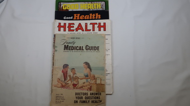
Magazines - Health, 1951, 1952, 1973, 1974, 1962
These magazines published articles on health for the family giving up to date information with diagrams on common health problems. Magazines with written Information was subscribed to by families at the time as transport and technology was not readily available in remote areas. The Upper Kiewa Valley situated in a remote part of Victoria didn't have easy access to health information. These magazines were available to farmers in the Kiewa Valley and to the workers and their families during the construction of the Kiewa Hydro Electric Scheme from the 1940s. With the introduction of improved transport and technology magazines eventually became less popular as a source of information. They are of interest in that they indicate the medical knowledge of the time and can thus be compared to current day knowledge.11 magazines with colorful covers and the occassional colored picture inside. Each has 32 pages. Periodicals - March, may, July, Sept, Nov. 1951 & jan. 1952. Also - Jan-Feb., Sept-Oct. 1973 and Mar, July-aug. 1974 Also Australian Women's Weekly supplement magazine 'Family Medical Guide' March 1962 with 47 pages. Inserted is a 16 page supplement (also Women's Weekly) dated Aug. 1976 titled 'Poison & First Aidhealth, magazines, medical guide, kiewa hydro electric scheme, kiewa valley -
 Kiewa Valley Historical Society
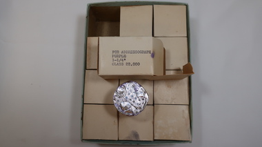
Ink Rolls - Labelling Cartridges for Addressograph Machine
The ink rolls were used in an addressograph machine. The addressograph machine used plates that contained names, addresses and classifications of each State Electricity Commission of Victoria employee working on the Kiewa Hydro Electric Scheme. The plates were put through the machine stamped in ink onto pay envelopes. See also: KVHS 0848, KVHS 1233The State Electricity Commission of Victoria employed many people on the Kiewa Hydro Electric Scheme and used the latest technology of the time to pay each of them including providing each one with a pay slip.2 large cardboard boxes, with lids, containing 3 by 4 rows of small white cardboard boxes. Inside the small boxes is a roll of ink covered by aluminium foil. Ref. KVHS 0848 which is the Addressograph MachineOn the end of one of the large boxes "For Addressograph / Purple / 1-1 and a quarter inches" / Class 22,000" Also a white label stuck on with '583' On each of the small boxes - For Addressograph / Purple / 1-1 and a quarter inches / Class 22,000 On the end of one of the lids handwritten in ink. "SF 125.7.0"addressograph machine; payroll; state electric commission of victoria; kiewa hydro electric scheme; office work; -
 Kiewa Valley Historical Society
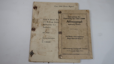
Books x2 - Addressograph, 1. Class 22000 Service Manual. 2. Instructions for Operating the Class 22000
The metal plate machine used plates that contained names, addresses and classifications of each State Electricity Commission of Victoria employee working on the Kiewa Hydro Electric Scheme. The plates were put through the machine onto pay envelopes. See also: KVHS 0848, KVHS 1046SECV employed many people on the KHES and used the latest technology of the time to pay each of them including each one with a pay slip.1. Thick yellowed paper. 21 pages typed one side only and 9 blank pages with 'Fig. 1' to 'Fig 12' typed. Fastened on the left side with 3 'document binders'. 1957 Issue 2. Cardboard cover with 40 pages of thick paper printed on both sides with black and white illustrations.1. Cover: Stott & Hoare. Pty Ltd. / 171 William St;, / Melbourne. C.1. / Australia / Text & Illustrations / By N.F. Vezener 2. Cover: Addressograph / Addressing Machine / Fourth Edition/ This Book is very Important / Please Read and Keep it / Addressograph - Multigraph Ltd. / Head Office & Works / 50 Oxgate Lane, Cricklewood / London. N.W. 2addressograph, secv, khes, pay slips -
 Kiewa Valley Historical Society
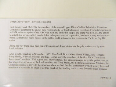
History of the Upper Kiewa Valley Television Translator, 1970's to 2014
The Television Translator was set up for people in the Upper Kiewa Valley who couldn't access the ABC, SBS and other channels of television from other transmitters in the area. Black spots were funded in 1999-2000. In 2014 new digital equipment resulted in the folding up of the committee and SBS took over.Historical: The history of providing television in the Upper Kiewa Valley to all residents and that of a community who worked towards achieving their aim. The history of technology for delivering television to people.A full box consisting of folders and papers relating to the History of the Upper Kiewa Valley Television Translator.television translator. upper kiewa valley. abc. sbs. -
 Kiewa Valley Historical Society
Addressograph Machine
This metal plate machine used plates that contained names, addresses and classifications of each State Electricity Commission of Victoria employee working on the Kiewa Hydro Electric Scheme. The plates were put through the machine onto pay envelopes.See also: KVHS 1046, KVHS 1233The S.E.C.V. employed many people on the Kiewa Hydro Electric Scheme and used the latest technology of the time to pay each of them including providing each one with a pay slip. Metal table with the addressograph machine set into the middle section. The electric machine is belt driven and controlled by three 52 cm long metal pedals. The operator uses 5 stops, 2 knobs and 1 winder while sitting at the machine. There are 5 extra metal parts (or pieces) which belong to this machine. Ref. KVHS 1046 - Ink Rolls - Labelling Cartridges for Addressograph MachineMetal plate attached to front of machine which reads "Class 22000 Serial No. B-01547. Addressograph regd. Addressing machine. Patents Pending Made in England Addressograph Multigraph Limited London.addressograph machine. state electricity commission of victoria. kiewa hydro electric scheme. payroll. office work. -
 Kiewa Valley Historical Society
Payroll Office Machine - S.E.C.V
This machine was used by the State Electricity Commission of Victoria on the Kiewa Hydro Electric Scheme by office workers who worked in the payroll office.The State Electricity Commission of Victoria used the latest technology available for office equipment on the Kiewa Hydro Electric Scheme. This machine was used in the payroll office.Black metal table with machine on top. Electric motor with belt drive to machine which is situated under the rear left side of the table. Safety metal mesh protects the leather belt and is at the rear of the table. The operator faces the machine which has a tray on the left and is divided longitudinally into two and holds new shiny metal plates on each side. There is a brown bakelite wheel on the left and two printing wheels inside a myriad of moving parts that enable the metal plates to be embossed with payroll information i.e. "Gang No. etc. / Names / Pay No. / Rate type. This has to be checked out each time / Date"ULQ 11 10"state electricity commission of victoria. kiewa hydro electric scheme. payroll office. office work. payroll machine. office equipment -
 Port of Echuca
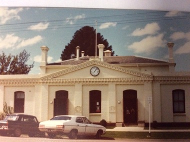
A rectangular coloured photograph, 1979
... . The Shire of Campaspe Information Technology Department has been ...This is a picture of the original Town Hall building built in High Street in the 1890's. It was designed by renowned Bendigo Architect W.C .Vahland. This picture was taken in 1979 when the Echuca Library was housed there. The Echuca Library operated out of this building from 1965 up to 2013 when the new library was built. In this photograph there are two people standing in the doorway and two cars parked in the street.This photograph is significant because it shows the first Town Hall building built in High Street in the late 1890's. The building was designed by W.C Vahland and was also used as the Law Courts before the Law Court building was built in Law Court Place. This building has also been used as the High School, while the Echuca High School was being built in the 1920's it was also used as a Kindergarten and the town Library operated there from 1965 to 2012 when the new Library was built. The Shire of Campaspe Information Technology Department has been housed there from 2012 up to the Present.A coloured photograph, in postcard size, of the original Town Hall building of Echuca, taken in 1979, when the building was being used as the Echuca Library.echuca town hall, echuca library, vahland, w.c -
 Federation University Historical Collection
Document - Document - Presentation, VIOSH: Social History; Introduction to Sociology of Work and Technology Presentation, post 1997
Victorian Institute of Occupational Safety and Health (VIOSH) Australia is the Asia-Pacific centre for teaching and research in occupational health and safety (OHS) and is known as one of Australia's leaders on the field. VIOSH has a global reputation for its innovative approach within the field of OHS management. VIOSH had its first intake of students in 1979. At that time the Institution was known as the Ballarat College of Advanced Education. In 1990 it became known as Ballarat University College, then in 1994 as University of Ballarat. It was 2014 that it became Federation University. VIOSH Australia students are safety managers, senior advisors and experienced OHS professionals. They come from all over Australia and industry. Students are taught active research and enquiry; rather than textbook learning and a one-size fits all approach. VIOSH accepts people into the Graduate Diploma of Occupational Hazard Management who have no undergraduate degree - on the basis of extensive work experience and knowledge. Brief outline of the history of the development of VIOSH, and those responsible. They were Derek Viner (the initial Course Co-ordinator), Mr Tom Norwood (Head of the Mechanical Engineering Department), Mr Eric Wigglesworth (Chairman of the Education Committee of the Safety Institute of Australia) and Mr Zig Plavina (Technical Officer in the School of Engineering and Secretary of the Campus Safety Committee). Dr Dennis Else from the University of Aston, Birmingham arrived to establish the Victorian Institute of Occupational Safety and Health within the Engineering division of the University. Following the introductory speech, the talk gave information on the development, problems and theory of designing safe workplaces.One A4 page typed.viosh, victorian institute of occupational safety and health, social history, sociology, derek viner, course co-ordinator, tom norwood, head of mechanical engineering, eric wigglesworth, chairman, education committee of the safety institute of australia, zig plavina, technical officer, school of engineering, campus safety committee, university of aston, dennis else -
Federation University Historical Collection
Book - Book - Scrapbook, Ballarat School of MInes: Scrapbook of Newspaper Cuttings, Book 59, December 1993 to February 1994
Collection of newspaper articles related to Ballarat School Of Mines.They cover activities and advertisements for staff. The papers concerned are The Courier, Ballarat, The Australian, The Age over the period of 1 December 1993 to 12 February 1994.Book with yellow cover, front, spiral bound. teaching positions advertised, pre-employment courses, courses available, enrolment for smb courses, blainey will head our uni, first chancellor, wayne braybrook, judy gerach, adult vce students, advanced certificate in horticulture, faith dickson, jarrad heighway, steamer restoration plans, trainee chef competition, customer service workshops, university city, a glorious future, student satisfaction with tafe, rebecca dobbell, tertiary places, smb vocational information centre, kirsten martin, master engineers, ronaldson brothers and tippett, uni denied funds, linola crop close to harvest, bendix workplace change, latest technology arrives