Showing 678 items
matching junction road
-
 Ringwood and District Historical Society
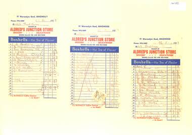
Document, Invoices from Alfred's Junction Store -91 Warrandyte Road Ringwood. 1953 to Mrs Pullen
... Invoices from Alfred's Junction Store -91 Warrandyte Road... Alfred's Junction Store -91 Warrandyte Road Ringwood. 1953 to Mrs ...Set of three grocery invoicesInvoices made out to Mrs Pullen. Hand written grocery items with prices. Invoices dated 1.6.1953, 10.6.1953, 26.5.1953 -
 Ringwood and District Historical Society
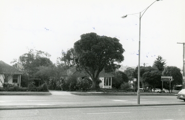
Photograph, Maroondah Highway. The house at the corner of George Road. Taken from the South side near the junction of Mt Dandenong Road on 10th September 1989, 1989
... . Taken from the South side near the junction of Mt Dandenong Road... the South side near the junction of Mt Dandenong Road on 10th ...Digital photograph -
 Ringwood and District Historical Society
Photograph, Maroondah Highway. The house at the corner of George Road. Taken from the South side near the junction of Mt Dandenong Road on 10th September 1989, 1989
... . Taken from the South side near the junction of Mt Dandenong Road... the South side near the junction of Mt Dandenong Road on 10th ...Digital photograph -
 Melbourne Tram Museum
Slide - Black and white reproduction photograph - HTT 19 Camberwell Jtn, 1920
... Junction from Riversdale Road into Camberwell Road. Has... Junction Camberwell Road tram 19 "MP9" in pencil Kodachrome ...Photograph - HTT bogie tram No. 19 crossing Camberwell Junction from Riversdale Road into Camberwell Road. Has the a letter "C" on the rear platform, which was the destination indicator for Camberwell Junction. In the view are a number of horse drawn carts, a motor cycle with a sidecar, Fraser Ironmonger, Dillons, H Evans & Co Real Estate agents advertising Eastern Heights Estate Saturday 20 March and the Commonwealth Bank. Saturday 20 March occurred in 1920. Original photo by Rose Stereograph Co. P 3525 - see reference.Yields information about Commonwealth Junction in 1920.Kodachrome cardboard duplicate slide - Black and white reproduction photograph - HTT 19 Camberwell Jtn 1920 "MP9" in penciltrams, tramways, htt, hawthorn tramways trust, camberwell junction, camberwell road, tram 19 -
 Whitehorse Historical Society Inc.
Document, Whitehorse Planning Scheme, 1/05/2001 12:00:00 AM
... junction road... no 142 junction road blackburn north no 17-21 lucknow street ...Amendment C3 Part 2 : Panel report with extract from minutes of Whitehorse City Council recording Council's resolutions to adopt the Panel's recommendations on Heritage overlay inclusions.Amendment C3 Part 2 : Panel report with extract from minutes of Whitehorse City Council recording Council's resolutions to adopt the Panel's recommendations on Heritage overlay inclusions.Amendment C3 Part 2 : Panel report with extract from minutes of Whitehorse City Council recording Council's resolutions to adopt the Panel's recommendations on Heritage overlay inclusions.whitehorse planning scheme, historic buildings, city of whitehorse, mount pleasant road, nunawading, no 129, longland road, mitcham, no 5, strathdon orchard, australian road research board, burwood heights uniting church, boronia road, vermont, no 142, junction road, blackburn north, no 17-21, lucknow street, mitcham no 55, haines street, no 38, gordon crescent, blackburn, no 18, blackburn primary school, no. 2923 -
Whitehorse Historical Society Inc.
Article, Council haggles over site of school, 2014
... Junction Road...Whitehorse Historical Society Inc. 2-10 Deep Creek Road ...Full cost of land at $15,000,000 too high for Whitehorse Council to pay the State Government for the Nunawading Primary School site.Full cost of land at $15,000,000 too high for Whitehorse Council to pay the State Government for the Nunawading Primary School site.Full cost of land at $15,000,000 too high for Whitehorse Council to pay the State Government for the Nunawading Primary School site.nunawading primary school no. 4190, springview primary school blackburn north, whitehorse primary school, junction road, blackburn north, ellis, sharon, ryall, dee -
Whitehorse Historical Society Inc.
Article, Old grove bears fruit, 2012
... Junction Road... Mitcham melbourne Junction Road Blackburn North Surrey Road ...A 1.03 hectare block, formerly an orchard in Blackburn North is now up for sale.A 1.03 hectare block, formerly an orchard in Blackburn North is now up for sale.A 1.03 hectare block, formerly an orchard in Blackburn North is now up for sale.junction road, blackburn north, surrey road blackburn north, cock, herbert -
Whitehorse Historical Society Inc.
Article, Blackburn North, 2013
... Junction Road Blackburn North... Blackburn North No. 59-67 Cock Herbert Junction Road Blackburn North ...Real estate advertisement for former orchard block of land in Blackburn North.Real estate advertisement for former orchard block of land in Blackburn North. Agent: Woodards. Aerial photo.Real estate advertisement for former orchard block of land in Blackburn North. surrey road blackburn north, no. 59-67, cock, herbert, junction road blackburn north -
Whitehorse Historical Society Inc.
Newspaper - Article, History buff fights for homestead, 3/08/1994
... Junction Road... Junction Road Blackburn North Nos. 17-21 Land Subdivision Keith ...Keith Rooney's appeal against subdivision proposal for 'Harwood' homestead comprising 1903 house and original earlier stables and coolroom.blackburn, edwardian style, rooney, keith, harwood, junction road, blackburn north, nos. 17-21, land subdivision -
 Whitehorse Historical Society Inc.
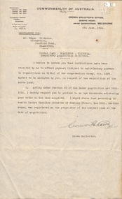
Letter - Correspondence, Postal land - Blackburn, 1/06/1924
... junction road... Mitcham melbourne land titles eriksson edgar junction road ...Letter from the Crown Solicitor to Edgar Erikson, orchardist, re compulsory acquisition of land for postal use. He was paid 264 pounds.land titles, eriksson, edgar, junction road, blackburn north, australia. crown solicitors office, johnston, louisa caroline, station street, box hill, post offices -
 Whitehorse Historical Society Inc.
Article, Off-lead Dog Areas, Sep 2023
... Junction Road Reserve... East Burwood Reserve Eley Park (North) Elgar Park Junction Road ...Ten newly declared off-lead areas are now available for dog walkersnon-fictionTen newly declared off-lead areas are now available for dog walkersbennettswood reserve, east burwood reserve, eley park (north), elgar park, junction road reserve, koonung reserve, slater reserve, springfield reserve, surrey park, whitehorse reserve -
Surrey Hills Historical Society Collection
Folder of real estate advertisements, Folders of real estate advertisements (Streets beginning with I-J), Various
... junction road... Road Canterbury melbourne inglisby road james street junction ...A4 folders with individual pockets for each property in streets beginning with I-J located in Surrey Hills and Mont Albert. Folders are ordered by street name and then chronologically by property number. Each property has its own pocket. This may include multiple real estate advertisements collected from sales over time. It may also include copies of any research undertaken by Alan Holt and / or members of the SHNCHC team. These are augmented by cards in the Alan Holt index file and by his property registers of Surrey Hills and Mont Albert.inglisby road, james street, junction road -
 Melbourne Tram Museum
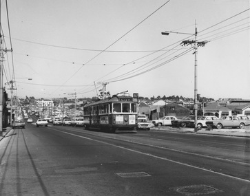
Photograph - W5 class 721 High Street, St Kilda, 1970s
... Kilda St Kilda Junction road widening Brighton Road W5 class ...Photograph of W5 class 721 city bound on route 67 ascends an uphill grade on a busy thoroughfare with numerous motor vehicles parked on vacant allotments along the southwest edge of the roadway. This is likely High Street, St Kilda at the commencement of road-widening works in the early 1970s. These works were to widen the narrow High Street between the wider Brighton Road and the newly rebuilt St Kilda Junction. Properties on the northeast edge of High Street remained. In these years the Carnegie route number changed from 4 to 67.Yields information about increase in motor vehicle traffic Black and white photograph with no notetram 721, route 4, route 67, high street st kilda, st kilda junction, road widening, brighton road, w5 class -
 Lakes Entrance Historical Society
Photograph - Princes Highway around Jemmys Point, Lakes Entrance, H D Bulmer, 1930 c
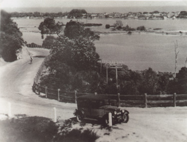
... at junction of original steep road to top of Jemmys Point. Man... Highway around Jemmys Point, car parked on road at junction... at junction of original steep road to top of Jemmys Point. Man ...Princes Highway around Jemmys Point, car parked on road at junction of original steep road to top of Jemmys Point. Man on bicycle riding up hill. Bullock Island and New Works in distance over North Arm and Cunninghame Arm waterways Lakes Entrance VictoriaBlack and white photograph of lower section of Princes Highway around Jemmys Point, car parked on road at junction of original steep road to top of Jemmys Point. Man on bicycle riding up hill. Bullock Island and New Works in distance over North Arm and Cunninghame Arm waterways Lakes Entrance Victoriaroads and streets, township, waterways, fences, vehicles -
 Whitehorse Historical Society Inc.
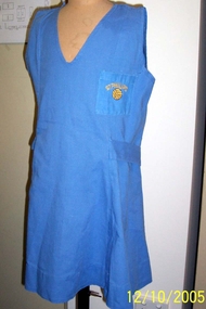
Clothing - Sports Tunic, 1987
... Primary School, Junction Road, Nunawading... Phillips Catholic Primary School, Junction Road, Nunawading ...Issued to net ball team during 1987 by St Phillips Catholic Primary School, Junction Road, NunawadingMid blue princess line sports dress. Half belt from side front, vee neck. Breast pocket embroidered with basket ball and the name St Phillips in gold colour with matching sports knickers.St Phillipsrecreations, sports -
 Melbourne Tram Museum
Slide - Set of 2, Keith Kings, 10/12/1967 12:00:00 AM
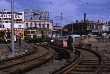
... Trams tramways St Kilda Junction Trackwork Road Works W2 class ...Set of two 35mm Kodak white cardboard colour slide by Keith Kings of: .1 - W2 600 testing the diverted track at St Kilda Jtn. Sunday 10/12/1967. Looking south See Keith's notes as well. Track welding being carried out. Tram showing Special. In the background are signs for Castrol, Speedie Electrical Appliances. .2 - W5 812 and W2 521 on the temporary track following the first diversion for the construction of the new bridge works looking north. Also see Keith's notes. 812 has adverts for wax and Harold's diamonds.Keith Kings stamp and number "14-23" and "14-28"", with details of exposure. .1 - "MMTB St Kilda Jtn bypass works. W2 600 as the test tram after the St Kilda Junction by Pass, No. 1 diversion trying out the south bound temporary track 3.03pm, Sunday 10/12/67. The North bound track tried out at approx. 12.40pm: .2 - "MMTB 521 (route 64 - City) and 812 (route 64 - East Brighton and Malvern Burke Road) on temporary track at St Kilda Jtn bypass. Note sharpness of curves and very limited transitions and tangents. Looking north. 10/12/1967trams, tramways, st kilda junction, trackwork, road works, w2 class, w5 class, route 64, east brighton, tram 600, tram 521, tram 812 -
 Melbourne Tram Museum
Slide - Set of 2, Keith Kings, 24/12/1967 12:00:00 AM
... Trams tramways St Kilda Junction Trackwork Road Works Dandenong ...Set of two 35mm Kodak white cardboard colour slide by Keith Kings of 24/12/1967 - .1 - St Kilda Junction, looking north along St Kilda Road, showing the nature of the diversion from the junction for Wellington St. .2 - Dandenong Road, showing the track diversion work for Dandenong Road/Queensway, Windsor.Keith Kings stamp and number "15-1" and "15-5"", with details of exposure. .1 - SW6 car on temporary track at St Kilda Junction looking north from turnout during freeway work .2 - Dandenong Road west from Hornsby St with section of straight track ready to replace curves onto new b.v.w. track to Chapel St - 907 coming off soon to be abandoned street track.trams, tramways, st kilda junction, trackwork, road works, dandenong road, queensway, tram 907 -
 Melbourne Tram Museum
Slide, Keith Kings, 21/09/1968 12:00:00 AM
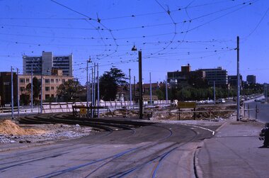
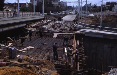
... Trams tramways St Kilda Junction Trackwork Road Works Queensway ...35mm Kodak white cardboard colour slide by Keith Kings of 21/9/1968 Photograph shows the construction of the tramway bridge section over the Queensway underpass at St Kilda Junction work. The junction for the Queensway section has been completed. See Keith's slide notes.Keith Kings stamp and number "34-10", with details of exposure. 21/9/1968 "Looking north over main underpass, excavation at tram overpass and trams"trams, tramways, st kilda junction, trackwork, road works, queensway -
 Melbourne Tram Museum
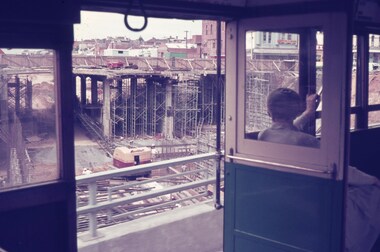
Slide, Keith Caldwell, Mar. 1968
... Trams tramways St Kilda Junction Trackwork Road Works St Kilda ...Agfa colour slide, blue / white plastic mount, photo by Keith Caldwell of a view from a tram southbound in St Kilda Road, looking down on the works to replace St Kilda Junction. Part of the work has been completed looking at the bridge structure alongside the tram. Shows the extent of the bridge construction work. 3/1968In ink "St K jct 3/68"trams, tramways, st kilda junction, trackwork, road works, st kilda rd -
 Orbost & District Historical Society
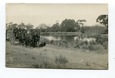
black and white photograph, late 19th - early 20th century
... on back - "at the Brodribb - Snowy junction. this road... gippsland This photograph was taken at the junction of the Snowy ...This photograph was taken at the junction of the Snowy and Brodribb Rivers. The Snowy River starts in New South Wales on the slopes of Mt Kosciuszko, Australia’s highest mountain, in New South Wales. It flows into Bass Strait at Marlo in Victoria. The Brodribb River is a tributary of the Snowy which enters the estuary at Marlo. This is a pictorial record of a road in Marlo near Orbost in the late 19th-early 20th centuries. It also depicts the transport used at that time.A black / white photograph of four men in suits seated in a horse - drawn buggy on a dirt road alongside a creek or river. There appears to be another horse - drawn vehicle behind them.on back - "at the Brodribb - Snowy junction. this road was corduroy (packed logs of tea trees?)brodribb-river snowy-river marlo transport-horse-drawn -
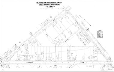
 Camberwell Historical Society
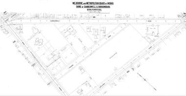
Map (Item) - MMBW map, Melbourne and Metropolitan Board of Works, Melbourne and Metropolitan Board of Works - Shire of Boroondara and Camberwell - Detail Plan no. 1852, August 1904
... MMBW Detail Plan showing Camberwell Junction, Camberwell...Camberwell Historical Society 25 Inglesby Road Camberwell ...Lithographer L.E, exd W.A.L., August 1904, no. 95. 40P. 15Wmelbourne and metropolitan board of works, map, camberwell, cartography -
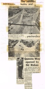 Melbourne Tram Museum
Newspaper, The Sun, The Herald, "The Junction today and Yesterday", "The Street that died" "Fare Rises attacked, Dec. 1968
... tram and road works. 1 - "The Junction today and Yesterday... Trams tramways St Kilda Junction Opening Brisbane Road Works ...Newspaper Clipping - set of four clippings adhered to two sides of two sheets of ruled quarto paper with punched holes on the left hand side - from newspaper about the St Kilda Junction tram and road works. 1 - "The Junction today and Yesterday", with photos of the St Kilda junction on 11/12/1968 and 1920, following the opening of Queens Way (road under the tram tracks_ by The Governor Sir Rohan Delacombe - from the Herald 11/12/1968. 2 - Keith Dunstan's a Place in The Sun about his visit to Brisbane and the closure of the Brisbane Tramway System - The Sun 11/12/1968 3 - "The Street that died" - the Sun 19/12/1968 - about the about the closure and removal of the tram tracks in Wellington St and its effect on the businesses. Has a photo of Frances Robinson of the St Kilda Post Office walking across demolished track tracks and wooden blocks. 4 - Trams - 20/12/1968 - about trams shunting at Malvern Depot 5 - two newspaper cuttings - "Fare Rises Attacked" - Monday 20-12-1968 - about proposed Fare Rises - quotes the Minister Mr Wilcox.trams, tramways, st kilda junction, opening, brisbane, road works, construction, malvern depot, wellington st, fares -
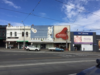 Kew Historical Society Inc
Photograph, Robert Baker, Kew Junction Streetscape, 2017, 01/09/2017
... Photograph of the junction of Cotham Road and High Street...) Photograph of the junction of Cotham Road and High Street, Kew. Kew ...Photograph of the junction of Cotham Road and High Street, Kew. the block - cotham road - kew (vic), cotham road - kew (vic) -
 Camberwell Historical Society
Map (Item) - MMBW map, Melbourne and Metropolitan Board of Works, Melbourne and Metropolitan Board of Works - Shire of Boroondara and Camberwell - Detail Plan no. 1851, July 1904
... MMBW Detail Plan showing Camberwell Junction, Camberwell.... MMBW Detail Plan showing Camberwell Junction, Camberwell Road ...Lithographer JEM, exd. JWD, July 1904, no. 81, 40P. 15W.melbourne and metropolitan board of works, map, camberwell, cartography -
 Melton City Libraries
Photograph, Myers Gully, 1935
... Myers Gully at the junction of Reserve Road, now known... at the junction of Reserve Road, now known as Ryans Creek Myers Gully ...Mary, Eliza and Ann Dowling arrived in Melbourne in June 1855 on the ship “Hotspur” as assisted immigrants. Mary married in Melton in 1857 to John Luby.The couple lived in Reserve Road Melton. Eliza married in Williamstown 1862 to William Daley a Bootmaker of Ann St, Williamstown. In 1865, Eliza and William lived in High Street Melton. Ann was a domestic servant in Williamstown and married Henri Miers in Melbourne in 1867.They built their house in Melton on the Ballarat road near the intersection of Reserveroad in 1867–Ryans Creek, referred to as Myers GullyMyers Gully at the junction of Reserve Road, now known as Ryans Creeklandscapes of significance, local identities, pioneer families -
Federation University Historical Collection
Reports, Big Cats Sightings and Stock Kills 2000-2011, 2000-2011
... Joyces Road Junction... connors plain giffard west darriment Joyces Road Junction Giffard ...The folder or correspondence is the result of a Freedom of Informaition request made to the Department of Primary Industries in 2011. The folder was collected for research being conducted by David Waldron.Folder of reports of Big Cat by rangers. australian mythical animals collection, david waldron, department of primary industries, rangers, peter walsh, warragul creek, binginwarri, coongulla, straford, licola, blanket hill, darramin, blanket hill, woodside beach, heyfield, puma, panther, cowwarr, glenmaggie, bolands bluff, darrimen, bolands bluff, binginnwarri, dawson, the springs, mt taylor, black range, driffield west, snowy plains airstrip, glenmaggie north, jack smith lake, munro, briagaling, dutson downs, connors plain, giffard west, darriment, joyces road junction, giffard west, wallaby creek, south gippsland highway, avon river, orbost, four mile creek -
 Melbourne Tram Museum
Photograph - Malvern Road and Glenferrie Road intersection, 1960s
... Road Junction works lighting milk bar mass concrete Black ...Photograph of Malvern Road and Glenferrie Road intersection showing the tram track H crossing with dual turnouts on the southwest and southeast corners. The tram tracks are at a lower level than bitumen roadway causing a rough undulating surface for motor vehicles. Extra works lighting is hanging from the overhead on one side of the junction suggesting future night works. This junction would eventually be relaid in mass concrete. A milk bar advertising various ice creams and other small shops are located at the intersection. Yields information about deterioration of tramway tracks and need for maintenance or replacement. Black and white photograph with no notemalvern road, glenferrie road, junction, works lighting, milk bar, mass concrete -
 City of Kingston
Photograph - Digital image, Black and white, Roads - Junction of Nepean Highway and South Road, c. 1950
... Black and white image of Nepean Highway and South Road...Junction of Nepean Highway and South Road, Moorabbin ...Junction of Nepean Highway and South Road, Moorabbin - Moorabbin Hotel on right. Shops in centre demolished for road widening in 1980'sBlack and white image of Nepean Highway and South Road junction point of view from Kingston Town HallPrinted in black text a round white sticker: 234 Handwritten in red ink 80% Yellow post it note written in blue ink: CHAP 7 234 / - Nepean Hwy + South Roadnepean highway, south road, moorabbin, moorabbin hotel -
 Melbourne Tram Museum
Photograph - St Kilda Road looking south, Melbourne & Metropolitan Tramways Board (MMTB), c1975
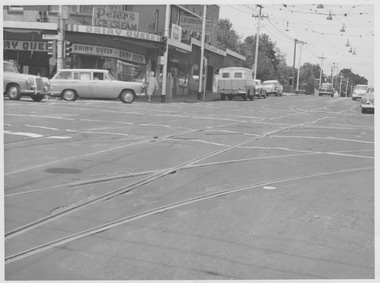
... On rear of photograph in ink "St Kilda Road Junction Stage... Junction St Kilda Rd On rear of photograph in ink "St Kilda Road ...Photograph of the south end of St Kilda Road, before the full reconstruction of High Street St Kilda (now St Kilda Road) but after the reconstruction of the Queens Road underpass, photo c1975. Shows the buildings at the junction including the Tower Hotel in the distance. Signs for advertising include Repco, Caltex Astron, UniRoyal Tyres, and Dunlop Tyres. The "Timeline history of Melbourne Tramways etc Barry George et al" gives the date of the opening of the High St section as March 1975.Yields information about the redevelopment of St Kilda Junction.Black and White Photograph with notes on the rear.On rear of photograph in ink "St Kilda Road Junction Stage One complete c1975"trams, tramways, high st, st kilda junction, st kilda rd -
 Kew Historical Society Inc
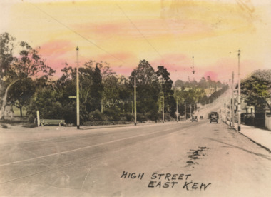
Postcard - High Street, East Kew, c.1927
... of significant road junctions: beginning at Barkers Road; progressing... of significant road junctions: beginning at Barkers Road; progressing ...High Street, Kew is the main Road in Kew. It was once also known as Bulleen Road, or Main Street. This section of the road is in Kew, although the narrow section on the right hand side of the photo is now Kew East. High Street progresses through a number of significant road junctions: beginning at Barkers Road; progressing through the intersection of Studley Park Road, Denmark Street and Princess Street at Kew Junction; branching left at the junction with Cotham Road; before reaching the junction with Valerie Street and Harp Road. It reaches its end at the junction of Burke Road, Kilby Road, Bulleen Road and High Street itself. An early photograph of this iconic Memorial that locates it in its context. Small, colorised real photo postcard of High Street, East Kew. Electric light poles line the road. Victoria Park is on the left and further on the horizon is the Boroondara General Cemetery.high street -- kew (vic.), victoria park, tram lines -- kew (vic.)