Showing 376 items matching "kitchener house"
-
 Marysville & District Historical Society
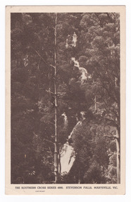
Postcard (item) - Black and white postcard, Stevenson Falls, Marysville, Vic, 1930
... , MARYSVILLE, VIC. POST CARD. Correspondence/ Address Mt. Kitchener.... Kitchener House/ Marysville Dear Dad,/ I'm having a/ great time up ...A postcard in a series produced by the Rose Stereograph Company in Victoria, Australia.A black and white photograph of Steavenson Falls, Marysville, Victoria. The Steavenson Falls is named after the Victorian Assistant Commissioner of Roads and Bridges, John Steavenson, who arrived in Victoria in the early 1860s. At 84 metres high, Steavenson Falls is Victoria's tallest cascading waterfall. The falls are split into roughly five cascades, with the last of these plunging into a small, picturesque rock pool. This postcard was produced by the Rose Stereograph Company as a souvenir of Marysville.THE SOUTHERN CROSS SERIES 4990./ COPYRIGHT/ STEVENSON FALLS, MARYSVILLE, VIC. POST CARD. Correspondence/ Address Mt. Kitchener House/ Marysville Dear Dad,/ I'm having a/ great time up here,/ I don't suppose you/ remember, but we used/ to walk up to see these/ falls when you were up/ here with me. I hope you/ like being at No. 6./ However, it won't be/ much longer now - I'll/ be home on Saturday./ Love to you all,/ Marjoriemarysville, victoria, waterfalls, stevenson falls, steavenson falls, southern cross series, 4990, postcard, souvenir, john steavenson -
 Warrnambool and District Historical Society Inc.
Domestic object - Laundry Tub, early to mid 20th century
... processes in the kitchen. Wash houses in the early to mid 20th... in the kitchen. Wash houses in the early to mid 20th century were usually ...This tub probably dates from the early to mid 20th century and would have been a common item in households in those times. It could have been used for laundry items or for other washing processes in the kitchen. Wash houses in the early to mid 20th century were usually separate buildings or sheds outside of the house.This item is retained for display and discussion purposesThis is an oval- shaped metal tub wider at the top than at the base. It has a ridged top, a strengthening metal band around the base and two metal handles. It is somewhat rusty.vintage household items, warrnambool & district historical society collection -
 Marysville & District Historical Society
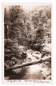
Postcard (item) - Black and white postcard, Rose Stereograph Company, Talbot Drive, Marysville, Vic. No. 3, The Taggerty River, 1913-1967
... / at Mt. Kitchener House before sallying forth for/ dinner... this note in my room/ at Mt. Kitchener House before sallying forth ...A postcard in a series produced by the Rose Stereograph Company in Victoria, Australia as a souvenir of Marysville.A black and white photograph taken along Lady Talbot Drive, Marysville, in Victoria, of the Taggerty River. Lady Talbot Drive is a 24 kilometer scenic rainforest car journey which passes a number of walks and waterfalls in the Yarra Ranges National Park. Lady Talbot Drive is named after Lady Sarah Elizabeth, the wife of Sir Reginald Talbot, who was the Governor of Victoria from 25th April, 1904 to 6th July 1908. This postcard was produced by the Rose Stereograph Company as a souvenir of Marysville.POST CARD The "Rose " Series/ De Luxe A Real Photograph/ Produced in Australia Published by the Rose Stereograph Co./ Armadale, Victoria. Dear John,/ I am writing this note in my room/ at Mt. Kitchener House before sallying forth for/ dinner. Unfortunately space does not permit/ me to tell you much, but I must let you know/ that yesterday morning (Monday), a blanket of/ snow covered the township of Marysville to a/ depth of three or four inches. Further up, near/ Keppel's Lookout, which we visited yesterday, it/ was nearly a foot deep everywhere, and it snowed/ the whole time we were walking./ Will tell you all later, your friend, Billtalbot drive, marysville, victoria, taggerty river, p. 2308, rose series postcard, postcard, souvenir, sir reginald talbot, lady sarah elizabeth talbot -
 Port Melbourne Historical & Preservation Society
Document - History, J Kitchen & Sons, Reg A Smith, Apr 1978
... , butter, butterine, marjarine and margarine from the House..., marjarine and margarine from the House of Kitchen". History of J ...Donated to PMHPS in February 2013 by Pentel/Symex Holdings, originally John Kitchen and Sons, after the sale of the Woodruff St Port Melbourne site. Arranged by Christine Wainwright, an employee of Symex of many years, who had been involved in the setting up their museum collection. Also Mary Kanellos, Symex.A4 typed pages titled "Candles, soap, apples, milk, cream, butter, butterine, marjarine and margarine from the House of Kitchen". History of J Kitchen and Sons in Melbourne.industry - manufacturing, business and traders - soaps/candles, unilever australia (holdings) ltd, j kitchen & sons pty ltd, reg a smith -
 Marysville & District Historical Society
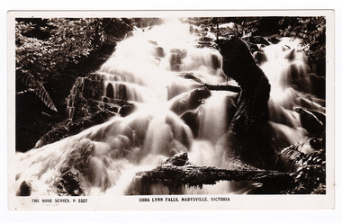
Postcard (item) - Black and white postcard, Rose Stereograph Company, Cora Lynn Falls, Marysville, Victoria, 1913-1967
... .,/ Armadale, Victoria. Kitchener House,/ Marysville/ Monday Dear Gwen... by the Rose Stereograph Co.,/ Armadale, Victoria. Kitchener House ...A postcard in a series produced by the Rose Stereograph Company in Victoria, Australia as a souvenir of Marysville.A black and white photograph of the Cora Lynn Falls which are in Cambarville. These falls are located on the Marysville-Wood's Point Road. Cambarville is notable for its giant mountain ash (Eucalyptus regnans) trees within the Cumberland Memorial Scenic Reserve, and relics from former sawmills and gold mining. The Big Culvert is located nearby on the Marysville - Woods Point Road, which was historically part of the Yarra Track. Cambarville was established as a timber mill town in the 1940s. Timber mill owners A Cameron and FJ Barton named Cambarville. They established the mill to salvage timber from trees destroyed in the 1939 bushfires. Cambarville was impacted by the 2009 Black Saturday bushfires and any remaining structures were destroyed. POST CARD The "Rose" Series/ De Luxe A Real Photograph/ Produced in Australia Published by the Rose Stereograph Co.,/ Armadale, Victoria. Kitchener House,/ Marysville/ Monday Dear Gwen,/ Just a line now/ as it's nearly dinnertime./ We went to these falls/ last week & also to the/ Cumberland falls. I took/ some photos but it was/ too dark with all the/ ferns in the gullies./ We went to the Eildon/ Weir on Friday - do you/ remember what part that is/ in? We also went to the/ Rubicon Power Station & to/ 2 of the big timber mills that/ were burnt out 2 yrs ago./ Well I must stop/ now & write to Bub/ Love from Joan Love from Auntie Mimacora lynn falls, cambarville, marysville, victoria, waterfalls, p. 2327, rose series postcard, postcard, souvenir, a cameron, fj barton, black saturday bushfires, mountain ash, mining, timber mills, 1939 bushfires -
 Ithacan Historical Society
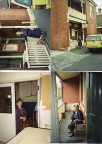
Photograph, Anthi Chilianis - House no. 10, 1994
... , Standing in the kitchen inside the house. ..., Standing in the kitchen inside the house. Anthi Chilianis - House ...Anthi Chilianis and her husband George lived in this house at 4 Hotham Street, South Melbourne for fourteen years from 1945 to 1959. They left the house when the family went to live in Ithaca. The house now houses a printing business. It was Anthi's favourite house and she and George often sat on the balcony drinking Greek coffee. Four photos showing different views of a terrace house in a narrow street. Clockwise from L-R: A lady standing in front of a verandah which is level with the street, A full view of the double fronted terrace house, Sitting on a seat on the narrow verandah, Standing in the kitchen inside the house. chillianis -
 Marysville & District Historical Society
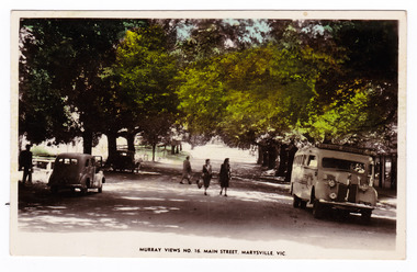
Postcard (Item) - Colour tinted postcard, Murray Views, Murray Views No. 16. Main Street, Marysville, Vic, c1940s
... BY MURRAY VIEWS, GYMPIE, Q. Tuesday 16th/ Mount Kitchener House.../ Mount Kitchener House/ Marysville Dear Bill & Fran,/ Just a card ...A colour tinted photograph of Murchison Street in Marysville in Victoria.A colour tinted photograph of the main street in Marysville in Victoria. This is now known as Murchison Street. This postcard was produced by Murray Views in Gympie in Queensland as a souvenir of Marysville.POST CARD STAMP REAL PHOTOGRAPH PRODUCED IN/ AUSTRALIA BY MURRAY VIEWS, GYMPIE, Q. Tuesday 16th/ Mount Kitchener House/ Marysville Dear Bill & Fran,/ Just a card hoping to find all well./ It is very cold night & mornings up here, only/ had a wet day though. The meals are very good/ here. I'm sure we shall both be pounds heavier./ Been fun 50th to be here, coming & going all the time./ We've been a few trips & for nice walks, some/ very stiff climbing. We are leaving here on/ Saturday morning & going to our friends at/ Heronswood for 2 or 3 days. Have you heard any/ thing of Bert's affair yet. We have been watching/ the papers. No more for now. Love to all./ Best wishes & love from us both - Bess. xoxmurchison street, marysville, victoria, murray views pty ltd, murray views no. 16., postcard, souvenir -
 Hume City Civic Collection
Photograph, Late 1980's
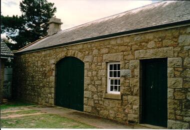
... The granite coach house and kitchen are part of the Glen... melbourne The granite coach house and kitchen are part of the Glen ...The granite coach house and kitchen are part of the Glen Loeman complex which is situated on Loemans Road in Bulla. Most of the buildings on the estate were constructed in the 1850's. The first owner of the property was Michail Loeman and his wife Isobella.A coloured photograph of outbuildings. The pitched roof is slate clad and is partly moss covered. The grey stone chimney stack at the end of the building is finished with a simple cornice. The stone walls are constructed in a random rubble pattern. There are two doorways. The wider doorway has black timber doors and is finished with an arched stone lintel and the smaller doorway has a straight stone lintel. The twelve paned sash window has a white painted frame and stone lintel and sill.granite, coach house, burns, joseph, loeman, michael, glen loeman, george evans collection -
 Marysville & District Historical Society
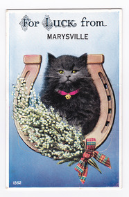
Postcard (item) - Novelty postcard, Valentine Publishing Co. Pty. Ltd, FOR LUCK from MARYSVILLE, 1940's-1960's
... / with only/ Name and/ Address of/ Sender 1 1/2 Mt Kitchener House.../ with only/ Name and/ Address of/ Sender 1 1/2 Mt Kitchener House ...A novelty postcard with pull-out strip of 9 miniature photographs that was produced by the Valentine Publishing Co as a souvenir of Marysville.A novelty postcard with pull-out strip of 9 miniature photographs that was produced by the Valentine Publishing Co as a souvenir of Marysville.FOR LUCK from/ MARYSVILLE 1852 VALENTINE'S/ MAILING NOVELTY From VALENTINE'S "MAILING NOVELTY" POSTCARD. COPYRIGHT. Postal Rates/ within Australia Enclosed in/ Envelope 2 1/2"/ Sent Open/ with only/ Name and/ Address of/ Sender 1 1/2 Mt Kitchener House/ Marysville/ 31.1.51 Dear Nancy & Albert/ Well I thought that while I had a/ chance I would drop you a few lines to/ let you know that we are having a good/ time. I read in the Herald last night about/ Uncle Will's death, but he had suffered such/ a lot, that I guess he is better off. When/ Dad & I went to see him last Tues week/ he really looked dreadful. This is a very/ nice place to stay the meals and accommod-/ ation is very nice & they are a very nice/ crowd staying here. Beryl & I went to Alexander/ yesterday with some friends of Beryl's and tomorrow/ we are going the Reefton Spur trip, ? and the Eildon Weir/ trip and then Frid the Cumberland Valley Trip./ Well I must close so for the present lots of Love/ Violetmarysville, victoria, souvenir, postcard, valentine publishing co, cumberland valley road (image 1), taggerty river (image 2), acheron way (image 3), the old ford marysville (image 4), nicholl's lookout (image 5), main street marysville (image 6), mount margaret (image 7), stevenson falls (image 8), cumberland falls (image 9) -
![Photograph - Digital Image, Ray White Greensborough, 3 St Helena Road Greensborough [interiors], 2017_](/media/collectors/4f729f5697f83e03086015b8/items/5d3c01c421ea6715d01f3f5c/item-media/5d3c01ea21ea6715d01f7078/item-fit-380x285.jpg) Greensborough Historical Society
Greensborough Historical SocietyPhotograph - Digital Image, Ray White Greensborough, 3 St Helena Road Greensborough [interiors], 2017_
... , kitchen and hallway. The house was built in 1920...), showing lounge, dining, kitchen and hallway. The house was built ...Interior photographs of the house at 3 St Helena Road Greensborough (corner Diamond Creek Road), showing lounge, dining, kitchen and hallway. The house was built in 1920. These photographs are from the Ray White sales brochure 2017. The 4 bedroom property sold in December 2017 for $900,000; previous sales: April 2009, $600,000; June 1981, $36,500; June 1976, $32,500. Digital copy of 8 colour photographs.st helena road greensborough, diamond creek road greensborough -
 Bendigo Historical Society Inc.
Photograph - AULSEBROOK AND MARTIN COLLECTION: INTERIOR OF HOUSE
... Colour photo: interior of house showing kitchen and dining...: interior of house showing kitchen and dining. Brown tile floor ...Colour photo: interior of house showing kitchen and dining. Brown tile floor in kitchen, brown cupboards, white laminex top. Light tan carpet, brown kitchen setting, ornate backs on chairs, brown flowered curtains. Possibly 1970's. On back of photo 'Aulsebrook & Martin Pty Ltd., Photographers, 6 Ruth Street, Golden Square, 3555. Phone 054 437565bendigo, business, aulsebrook and martin, photographers -
 Bendigo Historical Society Inc.
Photograph - T C WATTS & SON COLLECTION: THISTLE STREET, BENDIGO, 1931
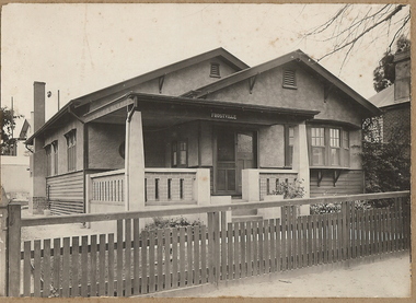
... single window on side plus 1 chimney ( kitchen ) Name of house... Inc. History House 11 Mackenzie Street Bendigo goldfields ...Black and white photographs (2) mounted on rectangular brown board. House, California-type bungalow wood and rough cast construction, 2 gables, bow window on right. Large square return verandah with brick and concrete balustrade. 2 double and 1 single window on side plus 1 chimney ( kitchen ) Name of house 'Frostville' centre beam of porch. Wooden slat front fence. On back of photo: A. McIntosh, Thistle Street, £1000 sewered or £950 plus sewer, 15.10.31' 2012 photo of house attached to record.Frank A. Jeffree Photo Bendigo [In Brown]bendigo, business, t c watts and son, s -
 Victoria Police Museum
Police Stations (Altona)
... '. There was also a kitchen, vestibule, wash-house, office, one W.C...'. There was also a kitchen, vestibule, wash-house, office, one W.C ...Altona is a suburb of Melbourne, 13 km south-west of Melbourne's CBD and located within the City of Hobsons Bay Altona Police Station opened as a temporary police station in 1919 in the Melbourne District. It was on the corner Sargood and Blyth Streets. It was staffed by one 1st Constable. The original police station was in a small room attached to the front of a 5-roomed weather-board dwelling with an iron roof on land measuring 66' x 165'. There was also a kitchen, vestibule, wash-house, office, one W.C. and a lock-up. In 1929 it became part of the Bourke District. On 31 March 1958 it moved into newly built government premises at 51-53 Blyth Street, on the corner of Bent Street. The building consisted of a cream brick veneer police residence and police station with cell. Staff was increased to a Sergeant in Charge and 3 Constables. A new police station was opened in Altona North on 7th October 1979. The Altona Police Station remained as a sub-station for a few a short time until the building was sold. July 2019 - a new police station is being constructed at 1 Galvin Street, Altona. Galvin Street was names after S/C Michael Arthur Galvin, 3651, who was appointed on 5 Jan 1886 and resigned on 4 Dec 1913. He was Werribee Shire President 1926-1927 and 1940-1941 8 black and white photos of new police station, 1963police stations; altona police station -
 Surrey Hills Historical Society Collection
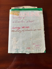
Journal - Hilary Bennet Mason's History of Charles Street, Surrey Hills
... Charles Street had a well under the kitchen window; the house... Charles Street had a well under the kitchen window; the house ...Hilary Bennet Mason (born 25/12/1911 in North Melbourne; died 16/3/2008) married Olive Marjory Muridge (B 20/7/1915; D 26/9/2001) on 30 September 1940. They has one daughter, born in 1947. Hilary had a number of occupations in his lifetime. His daughter referred to him as a tram conductor. The family lived at 7 Charles Street, Surrey Hills from c1960, having purchased it from William Stanton (Stan) Philp, a baker, and his wife Eileen. The title originally extended over 2 plots. The Philps sub-divided the land and built a new house for themselves at No 9. No 7 Charles Street had a well under the kitchen window; the house was extended in 1971/72; it was sold after Hilary Mason died in 2011. [REF: Personal communication from the donor; Alan Holt property register and online research.] The handwritten timeline refers to the area having been "called Irish Town as Catholic's were in the majority." Most of the writing is that of Hilary Mason, although some blanks have been filled in by another (unknown) hand. There is also an entry by John Whitford, who moved into a new home on the corner of Charles and Arthur Streets in 1982. The last entry is dated June 1996, when Hilary Mason would have been c 85 years old. Comment in relation to this catalogue entry: "One of the occupation that Mr Mason had was a Radio shop in Bridge Road, Richmond, called Mason's Radio. I worked for Mason's Radio in January 1963 to December 1964. Mr. Mason was a true gentleman, very kind and treated me like a son. Regards M.Zammit." (Maurice Zammit email; 9 March 2025)This is a unique piece of social history reflecting the closeness of this small suburban street.A standard lined exercise book, brand is HEADLINE, which contains a mixture of handwritten entries and pasted in and loose ephemeral items. These include house advertising flyers, newspaper clippings of a general nature and death notices, tickets, etc. The handwritten notes mostly pertain to a timeline of residents and their comings and goings to and from Charles Street in Surrey Hills, but also include some reflections on social history. Memories of other residents of the street are recorded. There are also some personal diary notes.Front cover: "begun october 1987 / History of / Charles street / Surrey Hills / History of Charles st. 1989 / 1996 / 1995 / 1993 1991 1990 / History 1987" in biro and marking pen in blue, red, brown and green. Back cover: "History / of / Surrey / Hills [1987 /1990 /1993 / 1995 / 1996] / History of / Charles street / Surrey Hills 1991" handwritten in black, blue, green, red and pink biro and marking pen.charles street, edna holzer, jack wright, john whitford, diana whitford, amanda whitford, melissa whitford, june kavanagh, aub sherlock, hilary bennet mason, olive marjory mason, noni hallier, elvis greenwood, bob peacock, ken warren, chris holford, enid holford, keith ellis, gina ellis, nita jacobsen, christine craig, peter craig, gary austin, deb austin, ian pearson, chris jacobsen, jack titansaw, peter burton, william (bill) philp, george cook, lee burton, mary pearson, bill sloan, carmel sloan, fielding's foundary, antonio panzera, annunziata panzera, nancy panzera, dr eric allan, merelyn maher, charles lyons, doug sloan, coral meehan, peter haase, steve creati -
 Melton City Libraries
Document, Minns Family Reunion, 2004
... of the building to house a kitchen, ablutions and laundry rooms and rooms... of the building to house a kitchen, ablutions and laundry rooms and rooms ..."A perpetual spring in the adjacent creek provided a steady supply of fresh water to the site on which the homestead is built. Although we can not be certain of the identity of the builder, the first stage of ‘The Willows’ homestead appears to have been constructed in the mid 1850s. The house is situated on Crown Allotment No.1 (No Section), Parish of Kororoit, an allotment of 5 acres 3 roods 4 perches. Although it had surveyed the land, the Crown did not offer it for sale until 22nd November 1861, at which time it was purchased by Charles March Williams. (Although the property is directly opposite and immediately adjacent to the Township of Melton, and was sold as ‘Suburban Allotment 33’, it was situated within the Shire of Braybrook rather than the Shire of Melton until 1917.) Considerable improvements had taken place on the land prior to the Crown sale. When CM Williams purchased the allotment in November 1861 he paid £23.5.0 for the land itself, and valued the improvements at £400. Even allowing for some exaggeration by Williams, this is an extremely high valuation for improvements, and must have included a house. Some local research has claimed that in 1858 Williams had taken over the interest of a Mr Parkinson in the property, and that Parkinson built the house upon taking possession of the land c.1855. It was definitely built by 1861, when a map shows a square building on the site marked as ‘House’. The property is important in the district for its association with the establishment of the pound. The district pound had been established in 1854, when George Scarborough of Mount Cottrell (Mt Cottrell Road, south of Greigs Road) was appointed pound-keeper. Scarborough resigned in 1857. The pound was moved to Melton following agitation from local farmers and Charles March Williams appointed pound-keeper on 26th April 1858. Williams, the son of a doctor, had been born in London. Reminiscences of local residents of the time, as recorded in the Express newspaper, note Williams’ success in breeding horses on the property. Sales of up to 60 guineas were noted. Whether this was from Williams’s own stock or from unclaimed pound stock is not made clear. Williams appeared before a government inquiry in 1860 and advocated registration of all stock brands in the State. Williams died in 1862 leaving a widow, Catherine, and five living children aged 15 years to five months. At the time of his death Williams had entered negotiations with one Matthew Devenish and had a mortgage of £100 on allotments 1 and 2, Parish of Kororoit. Catherine Williams was appointed pound-keeper on 2 September 1863, with her eldest son Charles as her assistant. Her tenure was short for on 22nd March 1864 George Minns senior paid Matthew Devenish £135 for allotments 1 and 2 Parish of Kororoit (considerably less than Williams had claimed the property was worth in 1861) and on the same day paid William Tullidge £45 for the adjoining allotments 3 and 4. In April 1867, James Ebden Minns, the newly married son of George senior became the owner of The Willows property having entered into a mortgage arrangement with his father to the extent of £200. At the time George Minns was residing in Kaarimba having left Melton in 1867 for a short trip to England and upon his return having taken up a selection in the Kaarimba district with his son Frederick who had a hotel licence there. James paid out the mortgage on 2-1-1873. James Minns was appointed pound-keeper in 1872; in 1885 the pound was moved elsewhere and Minns purchased the old pound site and added it to his farm. The Willows residence underwent a major change about this time. A two room extension, similar in style but with a lower elevation was added to the original rear of the house with a chimney matching the distinctive originals. Window arrangements did not match the original but became a feature of the façade when the new addition became the front of the building. Six buttresses were attached to the east and west walls of the old building, two to the south wall and the whole rendered with mortar to give the appearance of dressed stonework around the windows. Galvanized iron was placed over the shingles and a verandah added on three sides. By 1876 The Willows was the homestead for a thriving mixed farm of 340 acres of which 156 was rented from a H. Ruck. In October of that year the Australasian travelling reporter visited and reported on the property. In common with the nearly every other property in the district the farm had ‘recently’ (generally within the last two years) abandoned cultivation of crops, and turned over completely to cattle pasture. Butter making was the principal occupation of the farm, which had about 50 head of cattle, a large proportion of which were milking cows. The reporter also noted that a ‘large number of pigs are kept upon this farm and are found to be very profitable stock’. Their manure was used in an orchard and garden in which ‘large quantities of lucerne and prairie grass are grown for the use of stock when ordinary feed is scarce’. Two bores attached to deep brick lined wells supplied water for the house in addition to the farm. A commodious timber barn and necessary sheds had also been constructed. Access to the property was improved following the construction of the bluestone ford across the creek c.1887, when the recreation ground came into use. Prior to this date it may have been that the crossing referred to as ‘Mr Minns bridge’ was used. This appears to have been a flimsy structure and has but two references in Council reports in the Melton Express in the 1880’s. It is believed that in the late 1890’s a timber building was added near the rear of the building to house a kitchen, ablutions and laundry rooms and rooms for seasonal workers. This was attached to the house by means of a trellised walkway using the original front entry to the house (long since the back door). A photograph of this building appears in a local history of Melton. This was demolished in recent decades during the period when the house was tenanted (after the Minns family had left). James Minns son, George, took over the property following his marriage to Alice Walsh in 1903. James and Caroline moved into a house on the former JH Games property at the eastern end of Henry Street. George held the position of Shire Secretary for Melton for 40 years. He was a most prominent member of the community being Secretary to, among others, the Melton Coursing Club, the Shooting Club and the Cemetery Trust. He also rode with the hunting parties who sported across the Plains and were entertained at Mount Kororoit. George and Alice had one son, Norman who followed his father into local government and became Secretary of the Shire of Werribee completing a record term in this position. George retired to Werribee in 1951, where he died in 1965. The National Trust records note that James Ebden Minns and his sons were ‘leading men of the district, Justices of the Peace, and Shire Councillors’. It claims that Sir Thomas Bent was a frequent visitor. The Willows passed into the hands of George’s grandson, Bruce Minns and the property was let for a number of years. In the 1960s it became vacant and was subject to vandalism. Major structural problems arose with the part demolition of the roof, the loss of windows and doors and holes dug into and under the floorboards. The outbuildings were particularly targeted. Following widespread public support, the Shire of Melton purchased the house, with 3.75 acres of land, in 1972. In 1975 the Shire of Melton and the Melton and District Historical Society were successful in nominating the building for National Trust classification, and then the Australian Heritage Commission’s Register of the National Estate. The AHC particularly noted its ‘townscape importance’. It was envisaged that the farmhouse would form ‘a picturesque centrepiece to Melton’s planned … historical park, along with Dunvegan bluestone cottage … and similar structures as they become available.’ In a time of great Melton’s ‘satellite city’ development the Council spelt out its broader vision in its submission to the AHC: ‘Melton is destined to become, by the end of the present century, a city of between 75,000 and 100,000 people. Significant relics of the past, such as ‘The Willows’, regrettably will be rare in that situation. It is essential that sufficient tangible links with Melton’s pioneering days remain to promote in the new community a sense of history and continuity’. Under the direction of ‘The Willows’ Restoration Committee and consultant architect John Hitch, all outbuildings, with the exception of the garage and toilet, were demolished and the dwelling house restored. Finances were provided by the Shire of Melton and the National Estate Grants Program, and considerable amount of voluntary labour was provided by the local community. The orchard was removed, and remaining wooden buildings were relocated to provide an open vista for visitors to the Park. The property was furnished with donations from district families keen to preserve this example of pioneer life in the area. The Willows became the headquarters of the Melton and District Historical Society". Invitation to the family reunion at the Willowslocal identities, pioneer families -
 Warrnambool and District Historical Society Inc.
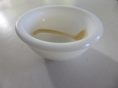
Artefact, White moulded dish, Mid 20th century
This dish is typical of those in use in households in the 20th century. It could have been used in the kitchen for holding condiments etc or for holding small items such as hairpins or nibs in other parts of the house. This item has no known local provenance but it is an attractive dish and is retained for display purposes. This is a white moulded glass dish with a rim extending over the top of the dish. household items, warrnambool history -
 Kiewa Valley Historical Society
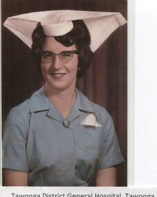
Photographs - Tawonga District General Hospital - Set of 21
In the early stages of the Kiewa Hydro-Electric Scheme the State Electricity Commission took over the financial and construction responsibility of the Tawonga District General Hospital building at a cost of 27,000 pounds. This included the removal and re-erection of the ex-military Bonegilla ward from Wodonga while in addition they carried out all the necessary building works that allowed the hospital to operate as a functional unit. The work was completed and handed over to the Hospital Committee of Management on September 1, 1949. Local residents raised 3,400 pounds through fund raising. The balance was met by the SEC and the Hospital and Charities Commission. The initial project was to provide for a basic temporary hospital which was later to include an Operating Theatre, Offices, Store, Mortuary and a Nurse’s Home, until the establishment of a permanent medical premises. Following the opening, 455 patients were admitted to the Tawonga District General Hospital and 254 operations were performed in the first year. The hospital relocated to Mount Beauty in the former SEC administration offices located in the town centre. Official opening of the 18 bed Tawonga District General Hospital on April 29 in 1961. Alpine Health CEO Mr Lyndon Seys oversaw the opening of the new Mount Beauty Hospital in November 2001 alongside Board of Management President Mr Andrew Randell, other board members and politicians. The Kiewa Hydro-Electric Scheme the State Electricity Commission played a pivotal part in the planning and initial funding of the Tawonga District General Hospital, with a view to providing medical support for its many workers on the Hydro scheme. Later, spouse and family members of workers were also able to access medical assistance The hospital was originally located in Tawonga away from the majority of the patients as the Hospital and Charities Board was not prepared to have it within the SEC controlled area. It was not until the gate at Tawonga South was taken down that the hospital was moved to the main centre of population at Mount Beauty. 1. Early nurses uniform; 2. Hospital Opening Ceremony; 3-7. Nursing Staff; 8. Delivery Room; 9. Mens Ward; 10.Enclosed Veranda; 11. Main Ward; 12-13. Kitchen; 14. Opening Ceremony 1949; 15.Original Hospital at Tawonga; 16-18. Relocated Hospital at Mt Beauty; 19. Rear of hospital and Matron’s quarters; 20. Hospital and Kiewa Valley House; 21. Renovated Hospital in 20001.Tawonga District General Hospital Tawonga; 2. Kiewa construction engineer Mr HHC Williams speaking at the opening of the hospital. Health Minister the Hon CP Gartside performed the official opening. L to R: TH Mitchell MLA; Manager of the hospital Mr RH Kronberg (obscured) Hon CP Gartside; CL McVilley; LT Knevitt; Matron AI Tarnish & W Sealey: 4. Dedicated Nursing Staff; 5. Nurse Campbell (nee Reid); 6. Sister Seager 1955 (nee Janice Burnett. First District Nurse; 7. L to R: Sister F Rosengrove; Sister J Griffiths; Matron AI Tarnish; Nurse D Satori; Nurse D Tregonning; Sister E Hill & Sister S O’Shannessy; 8. In the early years Tawonga District General Hospital had the second highest birth rate in Australia; 9. The men’s ward catered for men only in the early years of the hospitals operation; 10. The enclosed verandah at the original Tawonga District General Hospital allowed for an additional 10 beds; 11. Tawonga District General Hospital, Tawonga Main Ward. Ward ready and waiting for patients at Tawonga Hospital. Complete with lovely vases of flowers for every bed. Nice touch by the nurses; 12. Kitchen of Tawonga District General Hospital, Mt Beauty. The hospital kitchen provided meals for patients and a 3 course dinner for Meals on Wheels. In 1977, 11,795 meals were produced at an average cost of $2.60 per meal; 13. Tawonga District General Hospital, Tawonga. Kitchen. Kitchen staff employed in the old Tawonga District General Hospital 1949-1961; 14. The official opening ceremony of the Tawonga District General Hospital, 1949. The official ceremony was attended by a large number of residents and Tawonga District General Hospital was open for public inspection; 15. Original Tawonga District General Hospital transported form Bonegilla began operations in 1949; 16. In 1961, the Tawonga District General Hospital relocated to take a central position in the town of Mt Beauty in the former SEC Administration building; 19. The rear of the Tawonga District General Hospital and Matron’s house seen from Holland St, Mt Beauty during a snow storm in the mid 1960’s; 21. Tawonga District General Hospital & Kiewa Valley House, 2000. tawonga district hospital, mt beauty hospital, medical, health care, s.e.c. -
 Kiewa Valley Historical Society
Photographs - Demolition of the old Tawonga District General Hospital. Set of 8 colour photographs
In the early stages of the Kiewa Hydro-Electric Scheme the State Electricity Commission took over the financial and construction responsibility of the Tawonga District General Hospital building at a cost of 27,000 pounds. This included the removal and re-erection of the ex-military Bonegilla ward from Wodonga while in addition they carried out all the necessary building works that allowed the hospital to operate as a functional unit. The work was completed and handed over to the Hospital Committee of Management on September 1, 1949. Local residents raised 3,400 pounds through fund raising. The balance was met by the SEC and the Hospital and Charities Commission. The initial project was to provide for a basic temporary hospital which was later to include an Operating Theatre, Offices, Store, Mortuary and a Nurse’s Home, until the establishment of a permanent medical premises. Following the opening, 455 patients were admitted to the Tawonga District General Hospital and 254 operations were performed in the first year. The hospital relocated to Mount Beauty in the former SEC administration offices located in the town centre. Official opening of the 18 bed Tawonga District General Hospital on April 29 in 1961. The old weatherboard building was demolished around the late 1900’s to early 2000’s and replaced with a new modern brick building. Alpine Health CEO Mr Lyndon Seys oversaw the opening of the new Mount Beauty Hospital in November 2001 alongside Board of Management President Mr Andrew Randell, other board members and politicians. The Kiewa Hydro-Electric Scheme the State Electricity Commission played a pivotal part in the planning and initial funding of the Tawonga District General Hospital, with a view to providing medical support for its many workers on the Hydro scheme. Later, spouse and family members of workers were also able to access medical assistance The hospital was originally located in Tawonga away from the majority of the patients as the Hospital and Charities Board was not prepared to have it within the SEC controlled area and it was not until the gate at Tawonga South was taken down that the hospital was moved to the main centre of population at Mount Beauty.8 Colour photographs of the demolition of the original Tawonga and District Hospital situated in Mt Beauty circa 20001. No inscriptions 2. Side view of Tawonga District General Hospital, 1990’s 3. Demolition of the weatherboard hospital: Nurses station, ward and corridor 4. Demolition of the weatherboard hospital: kitchen & utility rooms 5. Demolition of the weatherboard hospital” front entrance & gardens 7. Demolition of the weatherboard hospital: Matrons House 8. No inscriptions tawonga & district general hospital; kiewa hydro electric scheme; mt beauty; -
 Kiewa Valley Historical Society
Photographs – Set of 10 black and white photographs and photocopies of original photographs documenting early residents of Bogong Village
Bogong Village, which was known as “The Junction”, is well recorded. The first tent camp was at the junction of Pretty Valley and Rocky Valley streams in the early 40’s. Further downstream were the sawmill, stables and blacksmith’s forge. Horses were the main mode of transport in the early days. The road to Bogong had reached the lookout spur just beyond Roper’s Spur track just before the 1939 fires. The early forties saw rapid growth of the village, with single and married men’s quarters, workshops, mess huts and administrative offices. The facilities necessary for communal living were quickly in place- a post office, police station, co-op store, medical centre, community hall/theatre, tennis courts and school. Much of the temporary accommodation that housed groups such as the Albion Quarrying Company were in the area now under water.This group of photographs are a pictorial record of the early history of the Kiewa Hydro Scheme, the people who worked in the background supplying administrative support and the workers and their families. It also shows a glimpse into how a large group of people from very diverse backgrounds came together to enjoy social activities and share each others companyGroup of 10 black and white photographs and photocopies of original photographs of varying sizes (some official SECV photos) Some Photos are labelled with the date and the names of SECV staff members. Depicting early life at Bogong Village 1. Group photo – Kiewa House Residents 1.8.41 (SECV official photo) 2. Female staff residents 3. Female office staff 4. Kitchen staff – Junction Mess (SECV official photo) 5. Male administration staff Bogong 6. Bogong Social Club fancy dress ball, 1940 7. Wives and children of SECV workers 8. Children in fancy dress 9. Opening of Volunteer Air Observers post 1943 10. Flag raising at opening of Volunteer Air Observers post 1. Printed under photo: STATE ELECTRICITY COMMISSION OF VICTORIA Date: 1.8.41 Time: 12.30pm No:K 435 Kiewa Hydro-Electric Works. Kiewa House Residents Back Row L to R: S.A. Salmon, W. Strachn, T.A Connors, W.J Norman, R.C Grealey, R.D Hegarty, Mrs Hegarty, W.R Morgan, S.A Clarke, P. Morgan, P.J. Harnetty, G.W Crouch. Front Row L to R: W.L Godfrey, R.S Hollands, Pte. R Charlesworth, R.L Dunn, N Caldwell, L.T Davies, I Webber, H.L Kendall, P Tiller, Ricky Hegarty, L.T Guy, M.C Cox, K.F Calder, D.S Gibson 2. Printed on bottom: Staff who lived at Kiewa House and worked in the Administration Office c 1943 Handwritten at bottom Priscilla Johnson (nee Reid) At top of page A GOOD LIFE: WOMEN’S RECOLLECTIONS OF LIFE IN THE UPPER KIEWA VALLEY 3. Printed under photo- Office Staff – Bogong 4. Printed under photo: STATE ELECTRICITY COMMISSION OF VICTORIA Date: 18.5.40 Time: 11.05am No:K 103. Kiewa Hydro-Electric Works. Kitchen Staff- Junction Mess. Opening night of the new staff mess Bogong. 5. Printed under photo -Administration staff Bogong 6. Printed under photo- The social club raised money for patriotic fund from fancy dress nights. (1st Fancy Dress Ball, Bogong 1940) 7. Printed above photo: ---- and family life begins (1942 Bogong) 8. Printed under photo: A favourite photograph 9. Printed under photo: STATE ELECTRICITY COMMISSION OF VICTORIA Date: 24.5.43 Time: 2.8pm No:K 1151 Kiewa Hydro-Electric Works. Bogong- Squadron Leader Leggett speaking at opening of Air Observer’s Post 10. Printed under photo: Raising the flag at the opening of the Volunteer Air Observer’s Post at Bogong - 1943 bogong village; kiewa hydro electric scheme; social activities; community clubs -
 Port of Echuca
Colour photograph, 1979
The Star Hotel was built in 1863 as a private dwelling, by James Shackell who owned the Bond Store, next door. It was a small house consisting of only a couple of rooms. In 1867 Joseph Salomon bought the house and converted it into a hotel. He built an underground bar to "deal with the peculiarities of the Echuca climate". It was called 'The Shades'. In 1890 Jane Pygall bought the hotel, which was described by the Riverine Herald as having ' three parlours, seven bedrooms, underground bar, kitchen, bathroom, outhouses, small stables, and entrance from two streets." She changed the name to The Esplanade Hotel. In 1890 it was de-licensed along with many hotels in Echuca. It had been a very popular drinking place for all the wharf workers, who continued to to drink illegally in the underground bar. It was then that the escape tunnel to the laneway was built , so the drinkers could escape the Police raids. For many years it was a private dwelling, or an office. In 1973 the City of Echuca bought the Star Hotel and resored it. At the time this photograph was taken it was the main tourist information centre for the Port of Echuca. It now operates as a hotel, serving meals and providing performance opportunities for musicians.The Star Hotel is very significant in Echuca's history due to its proximity to the Echuca Wharf. It was the closest bar to the wharf. Despite Jane Pygall trying to improve the quality of her clientele, the wharf drinkers preferred to drink at The Star Hotel, as the Bridge Hotel catered for more upmarket clientele. After de-licensing in 1897, the workers continued to drink at The Shades Bar and even put in place elaborate strategies to enable them to drink illegally there. It is now a large eating and entertainment site, and the public are still able to visit 'The Shades Bar'.A coloured photograph of the Star Hotel building in Murray Esplanade. The photograph is taken from the east side of the street. The Shackell's Bond Store can be seen on the left of the photograph. Printed on the back are the words, "This paper manufactured by Kodak". Also on the back is green Port of Echuca stamp. Written across the front of the Bond Store are the words 'World In Wax Museum.' On a sign outside the Star Hotel are the words, "Port Information Centre. Ticket Sales. Souvenirs . Star Hotel 1867."port of echuca, star hotel, shackell, james, salomon, joseph, pygall, jane, esplanade hotel, 1863, underground bar, the shades, de-licensing of echuca hotels -
 Eltham District Historical Society Inc
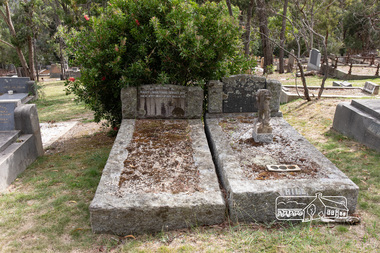
Photograph, Peter Pidgeon, Graves of Mary Josephine Swallow, John Swallow (unmarked) and Patricia Catherine Hill, Eltham Cemetery, Victoria, 5 April 2021
On the 29th of May 1954, a local Eltham carpenter by the name of John Swallow, committed a double murder at his home on New Street. This happened on the same day as the federal election of that year. John 48, his wife Mary 47, and stepdaughter Patricia 25, all went to the Eltham Courthouse on Main Road to cast their vote in the election that Saturday. After voting they returned home to their New Street house around midday. Patricia would later recall to ambulance officers, that she was feeling unwell, and so went to lay down when she heard an argument erupt over voting between her mother Mary and stepfather John. A concerned neighbour heard loud thudding noises and yelling coming from John and Mary’s house, he went to investigate. When he arrived at the house he was met by John at the front door. He would later describe John as “having a frantic look upon his face, and manic eyes”. John must have been a sight, bleeding and clutching a cut throat razor by his side. He then announced to the neighbour, “they voted commie!” before turning and going back inside. The distressed neighbour immediately raced home to call the Police. When the police arrived, they found Mary dead on the kitchen floor from catastrophic head injuries; her daughter, Patricia, clinging to life, slumped on her bed. Both women had been attacked by the same weapon, a large hammer, or sledge hammer as reported by the newspapers. John was also discovered in the house, bleeding from self-inflicted wounds from the razor, and had attempted to ingest caustic soda. Patricia was taken to St Vincent’s hospital, but died the following day, the 30th of May. John was also taken to St Vincent’s, where he remained under constant police guard for several months while he recovered from his injuries, at least the physical. He was eventually well enough to be taken to the City Watch House and then Pentridge Prison before his trial in October of the same year. When it came time for John to face the courts, the Judge called a mistrial, the Crown would not prosecute on the grounds of insanity. John was led away from the dock of The Magistrates Court and taken directly to Willsmere, the Kew Mental Asylum. On the 9th of August 1962, John Mervyn Swallow died of heart failure, he was 57. He had been a resident of Kew for four years. John’s body was returned to Eltham Cemetery and buried in the same grave as Mary. There is no mention of his name on the head stone. Patricia’s grave is next to Mary and John. A sad irony has an angel upon her grave, “its head missing”, possibly vandals or just an accident of time and events. What became of the home where all of this took place on New Street shall remain a mystery but within six months of this horrific event, the street had been re-named to Lavender Park Road after the original property near the end of the road, Lavender Park. In Memory Of Mary Josephine Swallow Died 29th May 1954 aged 47 Also Patricia Cathryn Hill Dearly beloved wife of Kel Called home 30th May 1954 Aged 25 yearsBorn Digitaleltham cemetery, gravestones, mary josephine swallow, patricia catherine hill, john swallow -
 Eltham District Historical Society Inc
Photograph - Digital Photograph, Jim Connor, River Bend House, 130 Laughing Waters Road, Eltham, 7 September 2013
Laughing Waters Walk, 7 Sep 2013 This Society excursion was a follow up to the Laughing Waters Story told to us by Jane Woollard at our Annual General Meeting in March 2013. It involved a walk commencing from the corner of Laughing Waters and Overbank Roads along Laughing Waters Road to its eastern end and returning partly over the same route - a total distance of about 2.5km. On the way we visited the two artist in residence properties, River Bend and Birrarung, to view the houses on them that are associated with Alistair Knox, Gordon Ford and others in the local mud brick and artistic community. We also able to walk around the derelict ruin which was once home to Gordon and Sue Ford, Boomerang House. An unexpected afternoon tea was offered to us by the artists in residence at Birrarung House and we had a brief opportunity to view inside the house. River Bend was designed and built by Alistair Knox for Rosemary and Bill Cuming in 1968. It sits in a deep cutting on a steep slope above the Yarra River and features floor to ceiling windows and glass doors set into mission brown timber frames and walls of reclaimed bricks in pinkish hue. Rosemary laid the brick paving around the house, a copy of the shell paving found in the ancient French town of Colmar, where the family had lived for a period. The kitchen was equipped with a 1960s stove as well as a cast iron wood stove reclaimed from Rosemary's sister's home in Armadale. Max and Tini Huygens, migrants from Holland, purchased the property in 1975 and named it Tilwinda from an Aboriginal word meaning 'hole in a rock'. In late 1981 Tini died after a short illness, but Max continued to live at Tilwinda until he moved to a retirement village in 2000 and the property was sold to Parks Victoria. Renamed River Bend, the property became part of the Laughing Waters Artist in Residency Program in 2008. Nillumbik Shire Council upgraded the property in 2012 with solar panels, a heat pump for hot water and double glazing to improve the comfort of the artists in residence and make the house more energy efficient. For a more in-depth description of the property and biographies of the various artists in residence commencing from 2008 to 2015, see Jane Woollard's book, "Laughing Waters Road; Art, Landscape & Memory in Eltham" published 2016.2013-09-07, activities, artists in residence, eltham district historical society, heritage excursion, jim connor collection, laughing waters road, river bend house -
 Eltham District Historical Society Inc
Document - Folder, McLean, 1984-1999
References to McLean family, Hector John McLean and Louisa Frances (nee Green) and six daughters who lived in Eltham during the period 1930 to 1934 inclusive. Lived in the former Evelyn Hotel at the time it was destroyed by fire and being part of the Centenary Parade in 1934 where the family won the Group Section for their entry “Pioneers of Eltham” Reminiscences provided by Edith Jones (nee M1934 flood, ballroom, baptism, barber shop, bittern, boy scouts, bremner's flat, burgoyne's shop, cable tram, cemetery road, centenary celebrations, centenary parade, christening, coach house, collis grocery, dalton street, depression, dole, dorothy jean mclean, edith jones (nee mclean), eltham fire brigade, eltham high school, eltham higher elementary school, eltham lower park, eltham railway station, eltham state school no. 209, evelyn hotel, fire damage - buildings, flinders naval depot, fordham, gladys evelyn mclean, gold mining, gwenneth mae mclean, gwladys evelyn mclean, headmistress, hector john mclean, isherwood house and shop, louisa frances mclean (nee green), metery road, methodist church, miss finnin, miss grant cottage, motor bike races, mrs barrett, mrs bremner, mrs hurley, olive isabel mclean, parade, phoebe lillian mclean, picnic, pioneers of eltham, pitt street, research fire brigade, rev. r.g. arthur, shed, shops, st margarets church hall, st margaret's church, stables, state savings bank of victoria, susso books, todaro, vinnie willet, warrandyte bridge, warrandyte, wingrove park, yarra river -
Glen Eira Historical Society
Article - Maysbury, Maysbury Avenue, 1, Elsterwick
An article in Melbourne Bayside Weekly, October 20, 2010 by architect Neil Clerehan giving the history of Maysbury and describing some of its architectural features, also a description of the building and grounds subdivision into individual houses in the newly created Maysbury Avenue and the building into seven individual flats and subsequent addition of seven more apartments. Included in the article are three coloured photographs of one of the exterior of the building and two of individual rooms in apartment No.7. Also three real estate advertisements including three coloured photographs, one of interior of apartment and two external views of Maysbury dated 2009 and 2010.maysbury, elsternwick, maysbury avenue, south road, labassa, gatsby, burreel avenue, grimwade house, glenhuntly road, glenmayne, biggin and scott real estate, mansions, architectural features, flats, bedrooms, living rooms, kitchens, bathrooms, arches, ceilings, fireplaces, architects, land titles, gardens, sheds, victorian style, italianate style -
 Eltham District Historical Society Inc
Document, Russell Yeoman, Tour of Historic Buildings and Locations, 1978
Self guided heritage tour information produced by the Shire of Eltham Historical Society for 1978 Eltham Community Festival of 36 locations each numbered on accompanying map. Locations and detail provided current to 1978: 1. ELTHAM SHOPPING CENTRE Whilst very little remains in the centre of historical importance, this area has interest as the "village" which developed over many years following the opening of the railway from Melbourne in 1902. Previously the shopping centre had been spread out over a long length of Main Road to the south. Shops have been continuously demolished or remodelled and the majority of buildings date from the 1950's or later. The recently erected Post Office replaced the "old" Post Office opened on the same site only in 1958. 2. WOOLWORTHS ELTHAM VILLAGE Part of the site of this modern shopping development was occupied by the former Eltham Shire Offices and Hall. The hall was paid for by public subscription whilst the Council raised a loan for the offices. The combined building was opened in 1941. It served as office and Council meeting place until 1965 and as the hall until its demolition in 1970. 3. ELTHAM WAR MEMORIAL The complex of buildings adjoining the present Shire Offices were financed by public subscription as a Memorial following World War II. Their construction and for many years their operation was organised by the now disbanded Eltham War Memorial Committee. The original buildings were the; Infant Welfare Centre, Children’s Library (now War Memorial Hall and Dental Clinic) and Kindergarten. In later years the Elderly Citizens Club was built at the rear. 4. ELTHAM SHIRE OFFICES These offices were opened in 1965 and extended in 1971 to provide additional office accommodation and the Eltham Library. They represent the last of a long line of offices and meeting places of the Eltham Shire Council and its predecessor the Eltham District Road Board. The building occupies the former site of Shillinglaw Cottage. The three tall cypress trees which stood in front of the Cottage have been retained as a feature of the office surrounds. 5. OUR LADY'S CHURCH AND SCHOOL The Catholic Church and School complex opposite the Shires Offices shows a number of stages in the development of Eltham township. The recently constructed church adjoins its predecessor (now the parish centre). Many years ago the Catholic Church was located opposite Wingrove Park and the present central site follows the northerly drift of the township. 6. SHILLINGLAW COTTAGE The Cottage was built in 1859 by George Stebbing, a local builder who was responsible for a number of other prominent buildings in the area. Its removal from the site of the Shire Offices and re-erection on the present site was financed by public subscription. It is built of handmade bricks laid in Flemish Bond with an unusual design featuring burnt "leader" bricks over the whole facade. The Cottage is occupied by Eltham Fleececrafts and will be open during the Festival and at other times during weekends. It is classified by the National Trust. 7. RAILWAY BRIDGE The timber trestle bridge over the Diamond Creek was built in 1901. Whilst all of its timbers have been replaced at various times over the years the only change to its character has been the addition of pylons and wiring for electric trains in 1923. It is one of very few similar bridges remaining in the metropolitan area. In 1976 a proposal to replace the bridge with an earth embankment and large culvert pipes was abandoned following community protests. The bridge, however, remains under threat because of the necessity for future deuplication of the railway line. 8. ELTHAM CENTPAL PARK The area between the railway and the creek has for many years been used as a park which included Eltham' s main football oval. The access road, Panther Place is named after Eltham's team playing in the Diamond Valley League. In recent years a large area extending to Bridge Street and locally known as the Town Park has been landscaped and added to the area. The excellent blending of the park with the natural landscape of the creek valley has earned a National Trust Landscape Classification. 9. OLD BAKERY On the southern corner of York Street and Main Road is an old house with a shop front which was for many years the local baker's shop. The brick bakery at the rear is of somewhat later vintage than the house. 10. BRIDGE STREET CUTTING Before reconstruction of Main Road this intersection had deep cutting embankments on all four corners, forming a distinctive feature of the entrance to Eltham. Roadworks and private development have levelled the land on the low side of the road. A memorial to the Eltham soldiers of World War I which was located at the north-western corner is now situated at the Eltham R.S.L. 11. HILLTOP MILK BAR For many years this was the site of the Eltham Post Office under the control of the Hunniford family and later their descendants the Burgoynes. It was transferred to this site in 1855, although at that time the building apparently fronted Bridge Str e et. The site contained Eltham's first telephone exchange. The post office was relocated in 1954 but the shop was operated until recently by the Burgoyne family who still own the surrounding land. 12. UNITING CHURCH and former C.B.A. BANK The former Methodist Church was built in 1880 by George Stebbing. The Sunday School extension was built in 1929 and there have been more recent extensions. The adjoining opportunity shop was built as a bank in 1874 and purchased by the Methodist Church in 1954. 13. R.S.L. HALL, TELEPHONE EXCHANGE These relatively recent buildings occupy the site of a row of shops forming part of the early ribbon of business development along Main Road. In front of the R.S.L. building is the World War I Memorial relocated from the corner of Bridge Street and Main Road. 14. ELTHAM COMMUNITY CENTRE Australia's first mudbrick "community building" was opened in April this year. Part of the site of the building was purchased in 1856 by Henry Dendy (of Brighton fame). At the rear of the land near the creek was a steam flour mill whilst Dendy's house was at the Main Road frontage of the land. His purchase totalled about 2 Ha (5 acres) and included land on the opposite side of Maria Street (Main Road). Dendy became a prominent member of the Eltham community and served one term as President of the Eltham District Road Board. In 1867 Dendy sold his land and business to William Ford of Malmsbury and shifted to Walhalla. The avenue of trees leading past the Community Centre to the creek may well have bordered the track to the mill. 15. ELTHAM HOTEL The original part of this hotel was built in 1927 following the burning of the former Watson's Eltham Hotel on the same site. The car park on the opposite side of Main Road was also the site of a hotel variously known over the years as; the Fountain of Friendship, the Fountain and the Evelyn Arms. As the Fountain of Friendship it was the first meeting place of the Eltham District Road Board in 1856. 16. ST. MARGARET'S CHURCH, PITT STREET In 1860 Henry Dendy was appointed Chairman of a committee to establish a church of England in Eltham. He donated part of his land in Pitt Street and in 1861 the church was opened. It was built by George Stebbing and remains in a well preserved state today. Th adjoining old vicarage is now named Dendy Hou se. A new mudbrick church hall is under construction on the site. The church and Dendy House are now listed on the Register of Historic Buildings. 17. NO. 86 PITT STREET Cottage built by George Stebbing and believed to be his home for some years in the 1850s. 18. LIVING AND LEARNING CENTRE The house was built in the 1850s with the kitchen at the front being added about 40 years later. By the creek below the house a number of early Eltham industries were located. These included a tannery and a brewery. 19. ELTHAM COURT HOUSE A Court of Petty Sessions was established in Eltham in 1858 and the present building dates from 1860. It is the oldest public building remaining in Eltham. In its early days the building was used as the meeting place and office of the Eltham District Road Board and as an overflow classroom for the local school. The Court House has been classified by the National Trust. The citation states that it is an example of the simple form of early brick Court House with gabled roof and porch. 20. LANDS DEPARTMENT OFFICE This building is the former police station and is probably of about the same age as the Court House. The lockup at the rear has been demolished but the old stables remain as garages. A licence was first granted for a police station at Eltham in 1856. 21. JARROLD COTTAGE The old Cottage opposite Dalton Street was formerly owned by the Jarrold family. Early records indicate that this was the building leased from the Jarrolds as a temporary police station prior to construction of the building on the corner of Brougham Street. The small building on the corner of the property was used as a boot repairer's shop. The elevated studio at the rear is a more recent construction by the present owners. 22. STATE SCHOOL RESIDENCE Erected in 1891 23. WINGROVE COTTAGE This building fills an important place in the history of Eltham and is now used as a medical clinic. It was built in 1858 for Charles S. Wingrove who was Secretary to the Eltham District Road Board and Shire Council from 1858 to 1904. During part of this period he was also Shire Engineer and was Secretary to the Heidelberg Road Board. The house was used as the office of the Board and Council for many years. Wingrove is buried in the cemetery at St. Helena. 24. WINGROVE PARK The parkland opposite Wingrove Cottage has been named after Charles Wingrove. The old Manna Gums are an outstanding feature of the park. 25. ELTHAM FRI.MARY SCHOOL NO. 209 The school first opened in the slab building in 1855 and operated from the present site since 1857. The oldest part of the present school is the stone building erected in 1876. The first school teacher, David Clark remained at the school until 1888. This school is the government township and has always been known as the Eltham School. An earlier school (no.371) known as Little Eltham School operated in Swan Street from 1853 to 1872. 26. "SHOESTRING" This house was built for school teacher David Clark. It has been extensively extended in recent years but the extensions do not detract from the character of the older part of the building. 27. ELTHAM CEMETERY The cemetery contains the graves of many of the district's pioneers . 28. MONTSALVAT This unique complex of buildings was commenced in 1935 by the late Justus Jorgensen and its development has extended over many years. Montsalvat has exerted a significant impact on Eltham The earth and stone construction of many of the buildings has influenced local architecture to a great extent and it has served as a "nerve centre" of the local artistic community. Montsalvat is open to the public for a small charge. 29. MAIN ROAD BRIDGE This location has been the main crossing of Diamond Creek since the earliest days of settlement. The present concrete bridge was erected in 1925 .and was preceded by a number of timber bridges. 30. ELTHAM LOWER PARK This park, being an unusually large flat area for Eltham, was originally the local racecourse. Horse races were held here from 1855 and the area was gazetted as a reserve for a racecourse and recreation reserve in 1857. The park is well known as a venue for school "bird days" and more recently as the site of the Diamond Valley Railway. This miniature railway features scale models of modern and old locomotives and rolling stock and has operated on this site since 1961 . Before that the railway operated at Chelsworth Park, Ivanhoe. 31. FALKINER HOUSE Frederick Falkiner was one of the earliest settlers in the Eltham township area and occupied a substantial leasehold prior to the first land sales. Early records show that Falkiner was the subject of a number of complaints from his neighbours but he has nevertheless been considered a prominent enough citizen to have a street named for him. This house was the home of Evelyn (Ely) Falkiner a member of Frederick's family. 32. WEST HOUSE Behind the large house on the hill is an early house built by the West family. This was relocated from a site near the front of the land by the present owner Mr. Fabbro. 33. FALKINER HOUSE This very old house is believed to have been the home of Frederick and may have been Eltham's first post office. Falkiner was the first post master for a short period. in 1854/55. 34. WITHERS HOUSE This house was the home of famous artist Walter Withers who shifted here from Heidelberg in 1903. 35. ELTHAM HIGH SCHOOL This school celebrated its jubilee this year, having commenced as the Eltham Higher Elementary School 50 years ago. 36. DIAMOND CREEK FOOTWAY If returning from the High School to the town centre the footpath by the bank of the Diamond Creek provides a pleasant route to finish your walk. The creek is a major tributary of the Yarra River. Together with its own major tributaries Arthurs Creek and Running Creek it commences on the southern slopes of the Dividing Range at Kinglake. It gives the name Diamond Valley to an area extending well beyond its actual drainage catchment.Recognition of the significance of various landmarks to the history of the Eltham community as of 1978‘shoestring’, 1978, bridge street cutting, burgoyne store, c.b.a. bank, diamond creek trail, eltham cemetery, eltham central park, eltham community centre, eltham community festival, eltham court house, eltham festival, eltham high school, eltham hotel, eltham lower park, eltham primary school, eltham railway trestle bridge, eltham shire offices, eltham shopping centre, eltham state school no. 209, eltham village, eltham war memorial, falkiner house, heritage trail, hilltop milk bar, jarrold cottage, lands department office, living, living and learning centre, main road bridge, montsalvat, old bakery, our eltham artistic recollections, our lady help of christian’s church, our lady help of christian’s primary school, pitt street, post office, r.s.l. hall, shillinglaw cottage, st margaret’s church, state school residence, stebbing cottage, telephone exchange, uniting church, west house, wingrove cottage, wingrove park, withers house, woolworths -
 Eltham District Historical Society Inc
Opening of Meruka Childcare Co-operative, Meruka Park, 5 Meruka Dr, Eltham, April 1994
In 1919 J.B. North, a violinist with the then Melbourne Symphonic Orchestra, and Monsieur Leon Lambert, a French architect, who later designed the Glaciarium Ice Skating Rink, purchased three available farms, Looker's, Wright's and Taylor's, approximately 60 acres, the area running along the creek and being bordered by the present day Ryans Road, Karingal Drive and Sherbourne Road. The farms were used for orchards and market gardens. Leon Lambert designed and built two homes on the farm site, one for the North family, ‘Tralford’, and the other, ‘Glen Ellen’, for himself and his wife. The homes were considered as "brother and sister" and they each included in their design an identical bay window in the main living area. "Glen Ellen" originally comprised kitchen, lounge room, inglenook, dining room, bath room and sleepout. Although the home has been extended over the years, much of the original architecture has been retained including timber panelling and three fireplaces. The land was subdivided in approximately 1966 with "Glen Ellen" retaining approximately one half acre of land fronting Meruka Drive. The property then passed from the Charleston family to Gerald and Margaret Sutton in 1976 and again was sold in 1980 and lastly sold again in 1994. The Norths named their house 'Tralford'. According to Marjorie North, the name Meruka was suggested by Alan Gardner and so was apparently not used by the North family. The name appears to be of Indian origin and its connection with the land is not known. ‘Tralford’ stayed in the North family for many years. Eltham Council acquired the house to create Meruka Park. The house was used for some years by the Council as a community arts facility and as emergency accommodation. It fell into disrepair and was demolished about 1990. The Meruka Child Care Centre has been built on the site and incorporates some of the architectural features of the old house. The Co-op was opened in April 1994. The original drive flanked by large old cypress trees remains. These trees are considered to be of local heritage significance and for this reason Meruka Park is covered by a Heritage Overlay under the Nillumbik Planning Scheme. Part of the park has been preserved as habitat for rare local flora. LL's house, named ‘Glen Ellen’, remains in a well-preserved state and fronts Meruka Drive.cr pam sladden, eltham, meruka child care co-operative, meruka house, meruka park -
 Eltham District Historical Society Inc
Opening of Meruka Childcare Co-operative, Meruka Park, 5 Meruka Dr, Eltham, April 1994
In 1919 J.B. North, a violinist with the then Melbourne Symphonic Orchestra, and Monsieur Leon Lambert, a French architect, who later designed the Glaciarium Ice Skating Rink, purchased three available farms, Looker's, Wright's and Taylor's, approximately 60 acres, the area running along the creek and being bordered by the present day Ryans Road, Karingal Drive and Sherbourne Road. The farms were used for orchards and market gardens. Leon Lambert designed and built two homes on the farm site, one for the North family, ‘Tralford’, and the other, ‘Glen Ellen’, for himself and his wife. The homes were considered as "brother and sister" and they each included in their design an identical bay window in the main living area. "Glen Ellen" originally comprised kitchen, lounge room, inglenook, dining room, bath room and sleepout. Although the home has been extended over the years, much of the original architecture has been retained including timber panelling and three fireplaces. The land was subdivided in approximately 1966 with "Glen Ellen" retaining approximately one half acre of land fronting Meruka Drive. The property then passed from the Charleston family to Gerald and Margaret Sutton in 1976 and again was sold in 1980 and lastly sold again in 1994. The Norths named their house 'Tralford'. According to Marjorie North, the name Meruka was suggested by Alan Gardner and so was apparently not used by the North family. The name appears to be of Indian origin and its connection with the land is not known. ‘Tralford’ stayed in the North family for many years. Eltham Council acquired the house to create Meruka Park. The house was used for some years by the Council as a community arts facility and as emergency accommodation. It fell into disrepair and was demolished about 1990. The Meruka Child Care Centre has been built on the site and incorporates some of the architectural features of the old house. The Co-op was opened in April 1994. The original drive flanked by large old cypress trees remains. These trees are considered to be of local heritage significance and for this reason Meruka Park is covered by a Heritage Overlay under the Nillumbik Planning Scheme. Part of the park has been preserved as habitat for rare local flora. LL's house, named ‘Glen Ellen’, remains in a well-preserved state and fronts Meruka Drive.eltham, meruka child care co-operative, meruka house, meruka park, cr. peter graham, peter staples, richard allen, sheryl garbutt, bill penrose -
 Eltham District Historical Society Inc
Opening of Meruka Childcare Co-operative, Meruka Park, 5 Meruka Dr, Eltham, April 1994
In 1919 J.B. North, a violinist with the then Melbourne Symphonic Orchestra, and Monsieur Leon Lambert, a French architect, who later designed the Glaciarium Ice Skating Rink, purchased three available farms, Looker's, Wright's and Taylor's, approximately 60 acres, the area running along the creek and being bordered by the present day Ryans Road, Karingal Drive and Sherbourne Road. The farms were used for orchards and market gardens. Leon Lambert designed and built two homes on the farm site, one for the North family, ‘Tralford’, and the other, ‘Glen Ellen’, for himself and his wife. The homes were considered as "brother and sister" and they each included in their design an identical bay window in the main living area. "Glen Ellen" originally comprised kitchen, lounge room, inglenook, dining room, bath room and sleepout. Although the home has been extended over the years, much of the original architecture has been retained including timber panelling and three fireplaces. The land was subdivided in approximately 1966 with "Glen Ellen" retaining approximately one half acre of land fronting Meruka Drive. The property then passed from the Charleston family to Gerald and Margaret Sutton in 1976 and again was sold in 1980 and lastly sold again in 1994. The Norths named their house 'Tralford'. According to Marjorie North, the name Meruka was suggested by Alan Gardner and so was apparently not used by the North family. The name appears to be of Indian origin and its connection with the land is not known. ‘Tralford’ stayed in the North family for many years. Eltham Council acquired the house to create Meruka Park. The house was used for some years by the Council as a community arts facility and as emergency accommodation. It fell into disrepair and was demolished about 1990. The Meruka Child Care Centre has been built on the site and incorporates some of the architectural features of the old house. The Co-op was opened in April 1994. The original drive flanked by large old cypress trees remains. These trees are considered to be of local heritage significance and for this reason Meruka Park is covered by a Heritage Overlay under the Nillumbik Planning Scheme. Part of the park has been preserved as habitat for rare local flora. LL's house, named ‘Glen Ellen’, remains in a well-preserved state and fronts Meruka Drive.eltham, meruka child care co-operative, meruka house, meruka park, cr. john cohen -
 Eltham District Historical Society Inc
Opening of Meruka Childcare Co-operative, Meruka Park, 5 Meruka Dr, Eltham, April 1994
In 1919 J.B. North, a violinist with the then Melbourne Symphonic Orchestra, and Monsieur Leon Lambert, a French architect, who later designed the Glaciarium Ice Skating Rink, purchased three available farms, Looker's, Wright's and Taylor's, approximately 60 acres, the area running along the creek and being bordered by the present day Ryans Road, Karingal Drive and Sherbourne Road. The farms were used for orchards and market gardens. Leon Lambert designed and built two homes on the farm site, one for the North family, ‘Tralford’, and the other, ‘Glen Ellen’, for himself and his wife. The homes were considered as "brother and sister" and they each included in their design an identical bay window in the main living area. "Glen Ellen" originally comprised kitchen, lounge room, inglenook, dining room, bath room and sleepout. Although the home has been extended over the years, much of the original architecture has been retained including timber panelling and three fireplaces. The land was subdivided in approximately 1966 with "Glen Ellen" retaining approximately one half acre of land fronting Meruka Drive. The property then passed from the Charleston family to Gerald and Margaret Sutton in 1976 and again was sold in 1980 and lastly sold again in 1994. The Norths named their house 'Tralford'. According to Marjorie North, the name Meruka was suggested by Alan Gardner and so was apparently not used by the North family. The name appears to be of Indian origin and its connection with the land is not known. ‘Tralford’ stayed in the North family for many years. Eltham Council acquired the house to create Meruka Park. The house was used for some years by the Council as a community arts facility and as emergency accommodation. It fell into disrepair and was demolished about 1990. The Meruka Child Care Centre has been built on the site and incorporates some of the architectural features of the old house. The Co-op was opened in April 1994. The original drive flanked by large old cypress trees remains. These trees are considered to be of local heritage significance and for this reason Meruka Park is covered by a Heritage Overlay under the Nillumbik Planning Scheme. Part of the park has been preserved as habitat for rare local flora. LL's house, named ‘Glen Ellen’, remains in a well-preserved state and fronts Meruka Drive.eltham, meruka child care co-operative, meruka house, meruka park, rob hauser -
 Eltham District Historical Society Inc
Opening of Meruka Childcare Co-operative, Meruka Park, 5 Meruka Dr, Eltham, April 1994
In 1919 J.B. North, a violinist with the then Melbourne Symphonic Orchestra, and Monsieur Leon Lambert, a French architect, who later designed the Glaciarium Ice Skating Rink, purchased three available farms, Looker's, Wright's and Taylor's, approximately 60 acres, the area running along the creek and being bordered by the present day Ryans Road, Karingal Drive and Sherbourne Road. The farms were used for orchards and market gardens. Leon Lambert designed and built two homes on the farm site, one for the North family, ‘Tralford’, and the other, ‘Glen Ellen’, for himself and his wife. The homes were considered as "brother and sister" and they each included in their design an identical bay window in the main living area. "Glen Ellen" originally comprised kitchen, lounge room, inglenook, dining room, bath room and sleepout. Although the home has been extended over the years, much of the original architecture has been retained including timber panelling and three fireplaces. The land was subdivided in approximately 1966 with "Glen Ellen" retaining approximately one half acre of land fronting Meruka Drive. The property then passed from the Charleston family to Gerald and Margaret Sutton in 1976 and again was sold in 1980 and lastly sold again in 1994. The Norths named their house 'Tralford'. According to Marjorie North, the name Meruka was suggested by Alan Gardner and so was apparently not used by the North family. The name appears to be of Indian origin and its connection with the land is not known. ‘Tralford’ stayed in the North family for many years. Eltham Council acquired the house to create Meruka Park. The house was used for some years by the Council as a community arts facility and as emergency accommodation. It fell into disrepair and was demolished about 1990. The Meruka Child Care Centre has been built on the site and incorporates some of the architectural features of the old house. The Co-op was opened in April 1994. The original drive flanked by large old cypress trees remains. These trees are considered to be of local heritage significance and for this reason Meruka Park is covered by a Heritage Overlay under the Nillumbik Planning Scheme. Part of the park has been preserved as habitat for rare local flora. LL's house, named ‘Glen Ellen’, remains in a well-preserved state and fronts Meruka Drive.eltham, meruka child care co-operative, meruka house, meruka park, irene bogle