Showing 195 items matching "molesworth"
-
 Supreme Court of Victoria Library
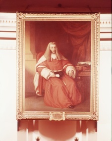
Portrait, Sir William a'Beckett
Correspondence held by the library has John Denniston Wood (1829-1914), a barrister and politician, presenting the portrait to the Library Committee in 1867. Wood hopes that the painting will "hang there [in the Court] in like manner as the portraits of many of the sages of the law are held in the Courts at Guildhall". Wood also provides information about the painter, Mr Mosely "now deceased", but who was "selected by Sir WIlliam himself" to undertake the commission. Early accounts have the painting hanging in a prominent position in the 'old' Court house at La Trobe and Russell Streets; the portrait was moved down to the library in 1884, when the portraits of Barry, Stawell and Molesworth were also commissioned. Sir William a'Beckett was the first chief justice of the colony of Victoria, having previously had a busy career at the Sydney bar. The portrait is of historic signifcance because of its subject Sir William a'Beckett and its long association with the Court. A full length portrait of Sir William a'Beckett, seated and dressed in his judicial robes. With ornate gold frame with acorn motif.Plaque identifying subject : Sir William a'Beckett, Knight, resident judge of the Supreme Court of New South Wales for the district of Port Phillip from 1846 to 1852, First Chief Justice of the Supreme Court of Victoria from Jan.1852 to Feb 1857.judges, william a beckett, supreme court -
 Kew Historical Society Inc
Archive (Sub-series) - Subject File, Kew Historical Society, Houses [Kew], 1980
Various partiesReference, Research, InformationSecondary Values (KHS Imposed Order)Assorted printed materials, some published, such as: ‘What House is That? A guide to Victorian housing’ (Heritage Victoria, 2004), and guidelines for researching the history of a house (Fact Sheet, City of Boroondara). There is an article from the Progress Press about the demolition of Ellesmore, 80 Princess Street in 1977 (the article includes photographs of the demolition), Elizabeth Mackie’s notes on Myrtle Hill, and an article on the restoration of Mynda, Molesworth Street that was published in the Trust News (1987). Mrs Sewell of Stawell Street wrote handwritten notes/recollections about Cradley in Studley Park Road in 1981. In the photocopy about Ellesmore, there is also a separate article on the proposed replacement of the Walmer Street Bridge. There is also correspondence and an article on Stanhope on the corner of Burke and Cotham Roads. The file includes general real estate information and data.kew historical society - archives, kew - history, myrtle hill (kew), ellesmore - 80 princess street - kew (vic), mynda - molesworth street - kew (vic), stanhope - burke road - cotham road - kew (vic), cradley - studley park road - kew (vic), 17 queen street - kew (vic.)kew historical society - archives, kew - history, myrtle hill (kew), ellesmore - 80 princess street - kew (vic), mynda - molesworth street - kew (vic), stanhope - burke road - cotham road - kew (vic), cradley - studley park road - kew (vic), 17 queen street - kew (vic.) -
Kew Historical Society Inc
Archive (Sub-series) - Subject File, Boroondara General (Kew) Cemetery - File 2, 1958
Various partiesReference, Research, InformationKHS OrderSubject file containing published and unpublished secondary sources / research about individuals and families buried in the Boroondara General Cemetery. Conglomerate files include: William Walton & family, Memories of the Linton Family (Lyne, J.A., 1997), and Sir Robert Wilson Knox (1934, 1969, 1973). There are notes and or photocopied information on Joseph Bosesto (1824-89), David Beath (1835-1922), Sir Robert Molesworth (1806-189?), Samuel Dougan Bird (1832-1904), Alexander Morrison, William Henry Archer ((1825-1909), Sir William Murray McPherson (1865-1932) and Sir Leo Cussen (1859-1933). The file also includes a single newspaper article/clipping on the burial of Sir Robert Knox (The Age, 1973). Held separately to this file is the Dorothy Rogers manuscript listing information inscribed on headstones of prominent citizens of Kew, with her annotations on these inscriptions.boroondara general (kew) cemetery - burialsboroondara general (kew) cemetery - burials -
 Bacchus Marsh & District Historical Society
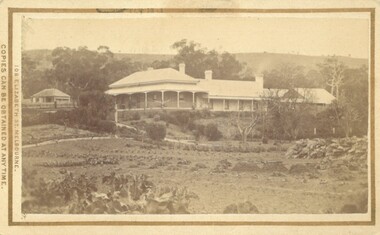
Photograph, Glenmore Homestead 1883
This homestead was built by Charles Griffith on a 55,000 acre Run. It replaced an earlier dwelling which was a slab hut with a bark roof. Charles Griffith, an Irish barrister, with his friend, James Moore, settled on Glenmore Station in the Parwan Valley in 1840. Their partnership lasted until 1848. In 1846, whilst in Ireland, Griffith married Miss Jane Catherine Magee, then returned to Glenmore and later took his nephew, Molesworth Richard Greene, into partnership, which arrangement proved to be long and prosperous. In 1857, they bought runs at Mount Hope and Mount Pyramid, which they kept until the days of free selection. Griffith led an active and successful public life.He was a member of the new Victorian Legislative Council in 1851, and was later an elected representative of the Legislative Assembly 1853-1859. He occupied many important public positions, including that of magistrate for Bacchus Marsh. Griffith was a devout Anglican and hosted Bishop Charles Perry at his station near Bacchus Marsh in 1849. He died in 1863 at his home in South Yarra.Small sepia unframed photograph on card with gold border framing photograph. Housed in the album, 'Photographs of Bacchus Marsh and District in 1883 by Stevenson and McNicoll'. The photograph shows a view of an extensive single-storey homestead consisting of three adjoining buildings, with a further building on the left of the main property. The series of three buildings is built in an elevated position, with pathways leading through a garden. At the front there is a vegetable garden which seems to be still in a state of development. The main house, possibly of brick, is set at an angle to the other two in this complex. It has a hip roof with a concave verandah on two sides with arched barge boards and simple unadorned pillars. There appears to be a hammock slung between two pillars. Two chimneys can be seen on this dwelling.The adjoining building is of a simpler design, with a lower roof line and a verandah running along the front. Two chimneys can be seen, one emitting smoke. This middle building may be a kitchen and rooms for day-to-day use. The third building is also of a simpler design, with a gable above a verandah. The purpose of this building is less clear. The different styles of construction suggest that these buildings were built separately at different times for different purposes. To the left of the main group of buildings is another cottage, smaller and of a simpler design. A fence runs along the front, clearly separating this building from the others, suggesting it may have been the dwelling of an overseer.On the front: Stevenson & McNicoll. Photo. 108 Elizabeth St. Melbourne. COPIES CAN BE OBTAINED AT ANY TIME. On the back: LIGHT & TRUTH inscribed on a banner surmounted by a representation of the rising sun. Copies of this Portrait can be had at any time by sending the Name and Post Office Money Order or Stamps for the amount of order to STEVENSON & McNICOLL LATE BENSON & STEVENSON, Photographers. 108 Elizabeth Street, MELBOURNE. stevenson and mcnicoll 1883 photographs of bacchus marsh and district, farms bacchus marsh, charles james griffith 1808-1863, glenmore station -
 Seaworks Maritime Museum
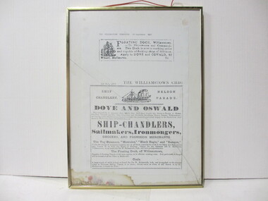
Framed print
Framed scan of two newspaper articles from "The Williamstown Chronicle" Article 1: "The Williamstown Chronicle 20 September 1856/ Floating dock, Williamstown. To Shipowners and Commanders./ This Dock is now in working order/ and capable of docking ships of 800 tons. Apply to DOVE and Oswald, 95/ Wharf Melbourne. 94." Article 2: "25 July 1857/ The Willaimstown Chro/ Ship Chandlery/ Nelson Parade/ Dove and Oswald/ Beg respectfully to acquaint their friends that they have bought the Stock in Trade of Messrs,/ Probert, Verdon and Co Ship CHandlers abd Proviso of Merchants Neslon Parade, Williamstown;/ stores in Melbourne have opened them as:/ SHIP CHANDLERS/ Sailmakers, Iron mongers, Grocers and Provision Merchants/ The tug steamers "Hercules," "Black Eagle" and "Samson"/ Under the charge of competent masters, are at all times available for work in the River and Bay and to/ take Vessels to or from the Heads or Geelong. Orders for the Steamers left in Melbourne,/ Willaimstown, or on board the Sir W Molesworth, hulk, will have prompt attention,// The floating dock, off Williamstown,/ Capable of Docking Vessels of 800 tons register is in efficient working order. Full particulars of charges/ will be furnished at the Office in Melbourne./ Coals/ A large supply of which is kept on board the Sir W Molesworth, hulk, can be supplied on the shortest / notice to steamers, sailing vessels or on shore; orders aken at either of the stores or by Mr/ McCallum, on board the hulk. -
 The 5th/6th Battalion Royal Victoria Regiment Historical Collection
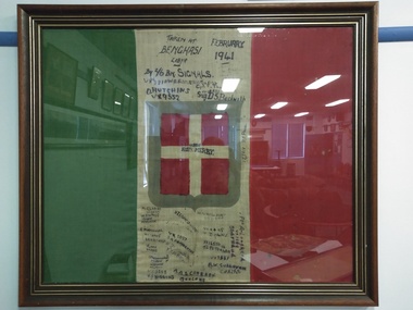
Flag - Framed Textile, Captured Italian Flag- Benghazi, 1941
Captured by 2/6 BN Signals in Benghazi Libya in February 1941Captured by 2/6 BN Signals in Benghazi Libya in February 1941Captured Italian Fascist flag mad of green, white and red cotton with black felt tip pen inscriptions on its white stripe." Taken at Bengasi Libya February 1941 By 2/6 BN. Signals VX3810 W.R. ANDERSON VX5124 CPL F. THOMPSON VX9552 O. HUTCHINS VX14051 Sig D.S. Beckwith VX 3900 RON. MERRY VX2418 R.F. PAIGE A. CLARKE VX3530 W.D. Whipp VX11631 Adelaide H.G. HOWARD VX1134 H.T. FRANCIS VX 5095 E. MOLESWORTH VX 14605 BRUNSWICK V. LUNN VX 3412 GEELONG WX 3588 X.A. HIGGINS VX 5037 S.A. PEMBERTON A.A.S. CAMERON GEELONG VX 4498 T. DOWNS VX15556 T.C. PETERSEN VX3661 B.W. SULLIVAN CARLTON PTE A.LONGHEED VX7589 St. Arnaud I.M. Cunningham VX 8416 ww2, 2/6 battalion, signals platoon, wark vc club -
 Melbourne Tram Museum
Drawing, Leonard J Flannagan, "Hawthorn Tramway Depot", 1915
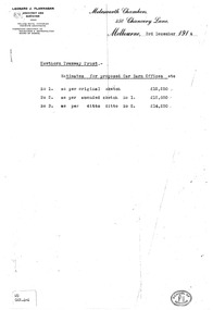
Set of 7 drawings for the development of the concept and layout of the Hawthorn Tramways Trust depot by the Architect Leonard J Flannagan, of Molesworth Chambers, 450 Chancery Lane, Melbourne. Item numbers match with the relevant image. .1 - Photocopy of a memo on the Architect's letterhead of cost estimates of three different options - dated 3/12/1914. Has a "School of Architecture" on the bottom right hand corner of the sheet and a sticker "WD GAR.4-4" giving a reference document number. Printed on an A4 sheet. .2 - Copy print of a pencil drawing - "Hawthorn Tramways Trust - Sketch Proposed Car Barn - Original Design Scheme No. 1". Reference Number in the bottom left hand corner "WD GAR.4-1". .3 - ditto showing floor plans with title "Alternative Plan No. 1" - Reference Number "WD GAR 4-6". .4 - ditto, with notes about items to be added in bottom right hand corner - Reference Number "WD GAR 4-6". .5 - as for .2 - "Amended design scheme No. 2" - Reference Number "WD GAR 4-5" .6 - Contract drawing - showing the elevation of the depot to Wallen and Power Streets - drawing No. 72, has both the names of the architect and the engineer in the bottom left hand corner. Note - amended drawing dated 6-5-15. Reference Number "WD GAR 4-5". .7 - Contract drawings - showing the first floor plan, internal elevation and the western or depot front elevation - drawing No. 71. Reference Number "WD GAR 4-7".trams, tramways, htt, hawthorn, architects, depot -
![Diary, [Digital file].1840-1841. Charles Griffith](/media/collectors/5e461d8021ea67224c82f2a1/items/67a209aff435c92f9910fa93/item-media/67a20ae0f435c92f9910fc3e/item-fit-380x285.jpg) Bacchus Marsh & District Historical Society
Bacchus Marsh & District Historical SocietyDiary, [Digital file].1840-1841. Charles Griffith
Charles Griffith was born in Kildare, Ireland in 1808. He studied at Trinity College, Dublin acquiring a B.A. in 1829 and an M.A. in 1832 before being admitted to practice as barister. In 1840 he emigrated to Australia arriving in the Port Phillip District in November 1840. Soon after arriving he and his friend James Moore formed a business partnership and acquired land in the Parwan Valley near Bacchus Marsh. This land had been in the possession of a Mr. McKenzie who agreed to sell his land and sheep to Griffith and Moore. The property they acquired came to be known as Glenmore. The partnership with James Moore lasted until 1848. In 1846, whilst in Ireland, Griffith married Miss Jane Catherine Magee, then returned to Glenmore and later took his nephew, Molesworth Richard Greene, into partnership, which arrangement proved to be long and prosperous. In 1857, they bought runs at Mount Hope and Mount Pyramid, which they kept until the days of free selection. Griffith led an active and successful public life. He was a member of the new Victorian Legislative Council in 1851, and was later an elected representative of the Legislative Assembly 1853-1859. He occupied many important public positions, including that of magistrate for Bacchus Marsh. Griffith was a devout Anglican and hosted Bishop Charles Perry at his station near Bacchus Marsh in 1849. He died in 1863 at his home in South Yarra. The diary is a detailed account of Griffith's voyage from Ireland to Australia and of his early months in Melbourne. After this it covers his early months establishing himself on his property, Glenmore, near Bacchus Marsh. The timeline of the diary stretches across 1840 and 1841. Griffith was an educated gentleman who made detailed observations about the environment he found himself in. The diary is particularly notable for Griffith's commentary about his interactions with people from first nations, and reveals some of his thinking about Colonial policies directed at first nations people. The diary also includes some sketches of individual first nations people along with some sketches of flora and fauna. The final part of the diary includes a glossary of Aboriginal words Griffith was familiar with. Digital file. PDF format. Digitised by State Library Victoria from photocopied pages of a hand-written transcription of the original diaries written by Charles J. (James) Griffith in 1840 and 1841.charles james griffith 1808-1863, diaries bacchus marsh, glenmore station, wadawurrung people, aboriginal australians bacchus marsh region history -
Kew Historical Society Inc
Archive (Sub-series) - Subject File, Kew Historical Society, Gardens (Kew), 1979
Various partiesReference, Research, InformationSecondary Values (KHS Imposed Order)Correspondence and newspaper articles/clippings relating to historic gardens in Kew. The oldest item is a letter from the National Trust Victoria announcing their two-year garden study and seeking information on gardens in Kew. Mavis Rolley, Secretary of the Society, made handwritten notes in response, which are kept in the file. She refers to: the pear trees planted by William Oswin in c. 1845 near what is now the Burke Road Bridge (she notes that a search for the trees at the time of the construction of the Eastern Freeway was unsuccessful), a camellia planted by the Dannocks near the corner of Derby and High Street, a c.1876 pine tree in Field Place, Henty Court, an 1875 Moreton Bay fig at Tarring, Ruyton, a Moreton Bay fig at Roxeth, Trinity Grammar, an 1840s oak tree and a 120-year old olive tree at Fairholme, Barry Street, 1870 pine trees at D’Estaville, Barry Street, trees at Turinville, Barnard Grove, dating to 1846, pine trees dating from 1845-6 on the Willsmere Farm, red gums in Victoria Park, pine trees in the Cemetery dating from the 1860s, trees in the Alexandra Gardens and at Kew Primary School, palm trees at La Verna, Sackville Street dating from the 1890s, the trees and gardens at Ross House (Charleville), and the trees at Merridale, Sackville Street which date from the 1880s, a magnolia at Lalla Rookh. These dates are probably highly contestable. Other handwritten notes from 1979 about significant gardens included: 5 Molesworth Street, Red Bluff - Redmond Street (garden now destroyed), Campion House, Studley Park Road, Raheen, Studley Park Road, Ross House, Cotham Road (Charleville), 7 Adeney Avenue, 20-21 Belmont Avenue, 52 Mary Street, an Edna Walling garden on the corner of Argyle Road and Victor Avenue, Merridale, Sackville Street, Roseneath, and Reno, St John’s Parade.gardens - private - kew (vic), garden design - kew (vic), kew horticultural societygardens - private - kew (vic), garden design - kew (vic), kew horticultural society -
 Kew Historical Society Inc
Photograph, Frederick Harwood Noble and Winifred Noble, c.1890
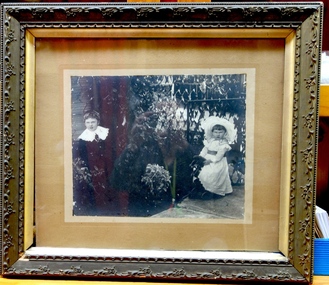
One of five group and individual portraits of the Noble family of Kew, two in the rear garden of what is presumed to be ‘Charnwood’, in Station Street, Coburg. The photographs date from the period c.1890-1914. One of the larger framed photographs is a portrait of the entire family group, while another is of two of the children, Frederick and Winifred. The father, Frederick William Noble was a businessman, and, at one period Secretary of the Victorian Creamery & Butter Company in South Melbourne. Later he was to manage J. Bartram & Co., Ice & Cold Storage Department in Flinders Lane. By 1906, the Noble family had moved to Kew, living for almost 20 years at 100 Walpole Street before relocating to 26 Molesworth Street in the mid 1920s. The five photographs in the collection reveal details of family life and social values as expressed through attire. The family is formally costumed in a manner indicative of their social status. Mrs Noble, in one of the large framed portraits, is dressed in a sombre manner in a long, dark-coloured long-sleeved, high-necked gown. It is difficult to know whether she is dressed in mourning wear in this black and white photograph. It was not uncommon for a woman to regularly wear mourning attire due to the high mortality rate in the Victorian era. This situation was compounded for women due to the size of extended families. A woman might rarely be out of mourning due to the death of a parent, a sibling, a husband, a child or a near relative. The portraits of the Noble family children, particularly Frederick and Winifred, show the elaborateness of formal attire worn by the children of wealthy families during the late Victorian era. Winifred is dressed in a long cotton dress and a broad-rimmed hat; both liberally covered in lace. Winifred and Frederick’s lace collars extend to their shoulders. Winifred’s diaries, covering the period 1908-50, are now in the collection of the State Library of Victoria. The most detailed of the diaries is from 1914, just before the outbreak of World War 1, and includes ‘Accounts of my Dancing Evenings - Season 1914’. The diaries were the inspiration for an art exhibition by Jim Pavlidis in 2014. One of the family’s two sons, Frederick, was to work at The Age newspaper for 50 years. His obituary records that “He was regarded as the epitome of accuracy and a fount of knowledge on many subjects, but especially cricket, the Royal Melbourne Show and Gilbert & Sullivan”. With Robert Morgan he compiled Speed the Plough, a history of the Royal Agricultural Society of Victoria and its role in developing agriculture in Victoria.A series of photographs that depict family life in the period 1890-1914. The family is significant and the children achieved success in a number of fields.Framed large albumen silver photograph of Frederick Harwood Noble and his sister Winifred in the rear garden of the family home in Coburg (sic). Later Label on rear reads ‘F.H. Noble, W.M. Noble’.winifred noble, frederick noble, charnwood (coburg), station street (coburg) -
 Kew Historical Society Inc
Photograph, The Noble family, c.1890
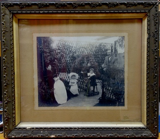
One of five group and individual portraits of the Noble family of Kew, two in the rear garden of what is presumed to be ‘Charnwood’, in Station Street, Coburg. The photographs date from the period c.1890-1914. One of the larger framed photographs is a portrait of the entire family group, while another is of two of the children, Frederick and Winifred. The father, Frederick William Noble was a businessman, and, at one period Secretary of the Victorian Creamery & Butter Company in South Melbourne. Later he was to manage J. Bartram & Co., Ice & Cold Storage Department in Flinders Lane. By 1906, the Noble family had moved to Kew, living for almost 20 years at 100 Walpole Street before relocating to 26 Molesworth Street in the mid 1920s. The five photographs in the collection reveal details of family life and social values as expressed through attire. The family is formally costumed in a manner indicative of their social status. Mrs Noble, in one of the large framed portraits, is dressed in a sombre manner in a long, dark-coloured long-sleeved, high-necked gown. It is difficult to know whether she is dressed in mourning wear in this black and white photograph. It was not uncommon for a woman to regularly wear mourning attire due to the high mortality rate in the Victorian era. This situation was compounded for women due to the size of extended families. A woman might rarely be out of mourning due to the death of a parent, a sibling, a husband, a child or a near relative. The portraits of the Noble family children, particularly Frederick and Winifred, show the elaborateness of formal attire worn by the children of wealthy families during the late Victorian era. Winifred is dressed in a long cotton dress and a broad-rimmed hat; both liberally covered in lace. Winifred and Frederick’s lace collars extend to their shoulders. Winifred’s diaries, covering the period 1908-50, are now in the collection of the State Library of Victoria. The most detailed of the diaries is from 1914, just before the outbreak of World War 1, and includes ‘Accounts of my Dancing Evenings - Season 1914’. The diaries were the inspiration for an art exhibition by Jim Pavlidis in 2014. One of the family’s two sons, Frederick, was to work at The Age newspaper for 50 years. His obituary records that “He was regarded as the epitome of accuracy and a fount of knowledge on many subjects, but especially cricket, the Royal Melbourne Show and Gilbert & Sullivan”. With Robert Morgan he compiled Speed the Plough, a history of the Royal Agricultural Society of Victoria and its role in developing agriculture in Victoria.A compelling group of family portraits. Members of the family were to achieve important roles as managers, journalists and writers.Framed and gazed albumen silver print of Mr and Frederick Warner Mrs Noble in the garden of their home in Coburg (sic) with their three children. There are minor losses to the gesso and paint of the original frame. Later labels to rear include: "Mr Noble, Mrs Noble’. ‘Frederick, Winifred, Wilfred"noble family, charnwood (coburg), station street (coburg) -
 Kew Historical Society Inc
Photograph, Portrait of Frederick Noble, c.1912
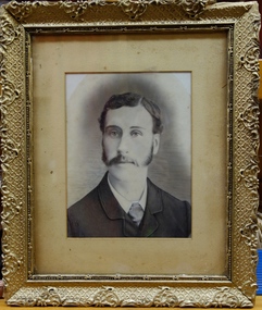
One of five group and individual portraits of the Noble family of Kew, two in the rear garden of what is presumed to be ‘Charnwood’, in Station Street, Coburg. The photographs date from the period c.1890-1914. One of the larger framed photographs is a portrait of the entire family group, while another is of two of the children, Frederick and Winifred. The father, Frederick William Noble was a businessman, and, at one period Secretary of the Victorian Creamery & Butter Company in South Melbourne. Later he was to manage J. Bartram & Co., Ice & Cold Storage Department in Flinders Lane. By 1906, the Noble family had moved to Kew, living for almost 20 years at 100 Walpole Street before relocating to 26 Molesworth Street in the mid 1920s. The five photographs in the collection reveal details of family life and social values as expressed through attire. The family is formally costumed in a manner indicative of their social status. Mrs Noble, in one of the large framed portraits, is dressed in a sombre manner in a long, dark-coloured long-sleeved, high-necked gown. It is difficult to know whether she is dressed in mourning wear in this black and white photograph. It was not uncommon for a woman to regularly wear mourning attire due to the high mortality rate in the Victorian era. This situation was compounded for women due to the size of extended families. A woman might rarely be out of mourning due to the death of a parent, a sibling, a husband, a child or a near relative. The portraits of the Noble family children, particularly Frederick and Winifred, show the elaborateness of formal attire worn by the children of wealthy families during the late Victorian era. Winifred is dressed in a long cotton dress and a broad-rimmed hat; both liberally covered in lace. Winifred and Frederick’s lace collars extend to their shoulders. Winifred’s diaries, covering the period 1908-50, are now in the collection of the State Library of Victoria. The most detailed of the diaries is from 1914, just before the outbreak of World War 1, and includes ‘Accounts of my Dancing Evenings - Season 1914’. The diaries were the inspiration for an art exhibition by Jim Pavlidis in 2014. One of the family’s two sons, Frederick, was to work at The Age newspaper for 50 years. His obituary records that “He was regarded as the epitome of accuracy and a fount of knowledge on many subjects, but especially cricket, the Royal Melbourne Show and Gilbert & Sullivan”. With Robert Morgan he compiled Speed the Plough, a history of the Royal Agricultural Society of Victoria and its role in developing agriculture in Victoria.Framed portrait of Frederick Noble"Frederick Noble". The name "PRENTICE" is handwritten below the label.noble family, frederick noble -
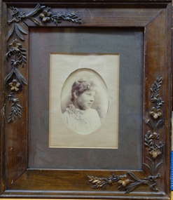 Kew Historical Society Inc
Photograph, Portrait of Mrs P.W. Noble, c.1870
One of five group and individual portraits of the Noble family of Kew, two in the rear garden of what is presumed to be ‘Charnwood’, in Station Street, Coburg. The photographs date from the period c.1890-1914. One of the larger framed photographs is a portrait of the entire family group, while another is of two of the children, Frederick and Winifred. The father, Frederick William Noble was a businessman, and, at one period Secretary of the Victorian Creamery & Butter Company in South Melbourne. Later he was to manage J. Bartram & Co., Ice & Cold Storage Department in Flinders Lane. By 1906, the Noble family had moved to Kew, living for almost 20 years at 100 Walpole Street before relocating to 26 Molesworth Street in the mid 1920s. The five photographs in the collection reveal details of family life and social values as expressed through attire. The family is formally costumed in a manner indicative of their social status. Mrs Noble, in one of the large framed portraits, is dressed in a sombre manner in a long, dark-coloured long-sleeved, high-necked gown. It is difficult to know whether she is dressed in mourning wear in this black and white photograph. It was not uncommon for a woman to regularly wear mourning attire due to the high mortality rate in the Victorian era. This situation was compounded for women due to the size of extended families. A woman might rarely be out of mourning due to the death of a parent, a sibling, a husband, a child or a near relative. The portraits of the Noble family children, particularly Frederick and Winifred, show the elaborateness of formal attire worn by the children of wealthy families during the late Victorian era. Winifred is dressed in a long cotton dress and a broad-rimmed hat; both liberally covered in lace. Winifred and Frederick’s lace collars extend to their shoulders. Winifred’s diaries, covering the period 1908-50, are now in the collection of the State Library of Victoria. The most detailed of the diaries is from 1914, just before the outbreak of World War 1, and includes ‘Accounts of my Dancing Evenings - Season 1914’. The diaries were the inspiration for an art exhibition by Jim Pavlidis in 2014. One of the family’s two sons, Frederick, was to work at The Age newspaper for 50 years. His obituary records that “He was regarded as the epitome of accuracy and a fount of knowledge on many subjects, but especially cricket, the Royal Melbourne Show and Gilbert & Sullivan”. With Robert Morgan he compiled Speed the Plough, a history of the Royal Agricultural Society of Victoria and its role in developing agriculture in Victoria.Framed oval portrait of Mrs P. W. Noble in a carved wooden frame."P. W. Noble" handwritten on label on reverse. noble family -
 Warrnambool and District Historical Society Inc.
Documents, William Ardlie Archives, C 1900-1940
This collection of papers have come from the offices of William Ardlie a local solicitor. He was born in Moonee Ponds in 1843 and was admitted as an attorney and solicitor of the supreme Court in 1865. From 1867 to 1878 he was in partnership with George Barber and then continued to practise until his late eighties which made him the oldest practising lawyer in Australia. He was involved in local councils and organisations such as the Hospital and Anglican Church.He was associated with several large homes in Warrnambool including Wyton presently the home of Emmanual College Warrnambool. He died in 1933.His son E L Ardlie also practised as a solicitor from the same offices from 1893. A number of the invoices included relate to the Estate of James drought who was a local policeman and owner of a number of properties and operated in various trades such as George Ramsay manufacturer of stoves and chimneys, J Rogers plumber & gas fitter and Christian & Dodds who were carpenters and joiners. There are a number of documents which relate to the Chinese, many of whom operated market gardens along the Merri River. They were a familiar part of Warrnambool from around 1872 until around 1940. The names mentioned in these documents include Ah Foo,Charles Quing Bow, Andrew Quing Bow Ah Bing Ah Jing Ah Moon and Ah Seong. They were reknown for their supply of fresh vegetables to the people of the town. They leased land from John Moore. These documents are a cross section of the types of documents which were used and are still used in the operation of businesses. They provide a social snapshot of people and the business which they conducted with their solicitors in this case William and E L Ardlie who were a long standing legal firm in the district. Another interesting aspect of some of these documents is the leases signed by the Chinese market gardeners who played an important but often overlooked aspect of Warrnambool's aspect.A total of 27 documents which relate to William Ardlie Solicitors 001133.1Policy from The Victoria Insurance Company for office effects, 001133.1.2 Receipt for 11/1 for policy. 001133.2 Renewal Receipt from Messrs Hammond & Richards as agents for Victoria Insurance Co. 001133.3 Renewal Receipt from Messrs Hammond & Richards as agents for Victoria Insurance Co. 001133.4 General rates receipt . City of Warrnmbool. 001133.5 Water rates receipt . City of Warrnmbool. 001133.6 Camperdown Chronicle , Letter re overdue payment 001133.7 Camperdown Chronicle Statement 31/12/1948 001133.8 Transfer of land notice Ben Rogers Mepunga 001133.9 W H Philpott Account for rent Estate R P Thomas 001133.10 George Ramsay account for Mr Walters for stove setting. 001133.11 Archibald Macfarlane & Co account for Estate James Drought for advertising. 001133.12 Letter to E L Ardlie re deed of Keane family arrangements 21/10/1910 001133.13 Letter to E L Ardlie re charges of Keane Estate 14/12/1910 001133.14 Account to E L Ardlie from J Rogers re estate Mr Drought , repairs.1/08/1906 001133.15 Account to EL Ardlie from J Rogers re estate Mr Drought1/10/1907 001133.16 Account to William Ardlie from J Rogers re estate Mr Drought 01/07/1908 001133.17 Account to William Ardlie from J Rogers re estate Mr Drought 01/07/1908 001133.18 State Savings Bank Victoria passbook of Margaret Molan 1/02/1937 001133.19 Account to E L Ardlie from Christian & Dodds repairs to Droughts house 01/07/1905 001133.20 Account to E L Ardlie from Christian & Dodds for Estate of Drought for house repairs Darling St1/10/1905 001133.21 Estimate to A A Briggs from Christian & Dodds for Estate of Drought 06/04/1908 001133.22 Receipt to E L Ardlie from Christian & Dodds for Estate of Drought for house repairs 01/05/1906 001133.23 Lease Indenture 02/06/1922 between William Ardlie andAH Foo re Crown Allotment 144 Wangoom for 70 pounds. 001133.24 Agreement 18/06/1929 Messrs Quing Bow & Sons to Messrs Ah Bing Ah Jing Ah Moon and Ah Seong witnessed John Moore. 001133.25 Lease indenture made 18/06/1929 betweenWilliam Ardlie to messrs Ah Bing Ah Jing Ah Moon and Ah Seong. 001133.26 Agreement 18/06/1929 Messrs Quing Bow & Sons to Messrs Ah Bing Ah Jing Ah Moon and Ah Seong witnessed John Moore 001133.27.1 Notification to Creditor of issue of stay order farmers Debts adjustment Act 1935 to Ellen C McGinness and Estate of john McGinness 001133.27.2Note re monthly inst of interest Estate McGinness1942 001133.27.3 Estate of j A Bromfield re Estate of McGinness Arrears of Interest1943 001133.27.4 Letter to W Ardlie from The Trustees Executors & Agency Co Ltd24/02/1944 re interest on J A Bromfield's trust re McGinness mortgage. 001133.27.5 Letter to W Ardlie from The Trustees Executors & Agency Co Ltd 25/02/1944 re interest on J A Bromfield's trust re McGinness mortgage. 001133.27.6 William Ardlie to The Trustees Executors & Agency Co Ltd re Bromfield & McGinness 24/02/1944 001133.27.7 The Trustees Executors & Agency Co Ltd to William Ardlie re receipts 16/03/1944 001133.27.8 The Trustees Executors & Agency Co Ltd to William Ardlie re Bromfield & McGinness18/03/1944 Unable to complete enquiries. 001133.27.9 The Trustees Executors & Agency Co Ltd to William Ardlie 27/03/1944 001133.27.10 The Trustees Executors & Agency Co Ltd to William Ardlie29/04/1944 001133.27.11 Estate Sarah Donaldson re accrued Interest 1933-1961 001133.28.1 Indenture between Emily Maria Briggs,Mary Jane Briggs, Frederick William Briggs, Fanny Alethea Briggs, James Alfred Briggs,Lucy Annie Briggs, Arthur Albert Briggs , and Mary Ann Briggs 001133.28.2 Letter re estate of Mary Ann Briggs 001133.1 No 590911 001133.1.2 Signed G Begley 001133.2 Hammond & Richards 43/5 Kepler St Warrnambool 001133.3 Hammond & Richards 43/5 Kepler St Warrnambool 03/03/1934 001133.4 W Ardlie 18/06/1929 Thomas Beattie collector 001133.5 W Ardlie 18/06/1929 Thomas Beattie collector 001133.6 Wm Ardlie signed W A Donald10/08/1949 001133.7 Wm Ardlie 31/12/1948 001133.8 Alexander Ben Rogers 26/05/1950 001133.9 Estate R P Thomas 28/061955. Phone 124 001133.10 .Mr Walters Drought A Ramsay 01/05/1906 001133.11 Estate of the late James Drought 24/05/1906 001133.12 W F Molesworth Re Thomas Keane. Phone 81. 21/10/1910 001133.13 W F Molesworth Phone 81 Thomas Keane14/12/1910 001133.14 E L Ardlie Joseph Rogers 13/08/1906 001133.15 E L Ardlie Joseph Rogers 01/10/1907 001133.16 E L Ardlie 01/07/1908 001133.17 Estate Late Mr Drought 01/07/1908 001133.18 Miss Margaret Molan 001133.29 L Ardlie 01/07/1905 001133.20 E L Ardlie 01/10/1905 001133.21 Mr A A Briggs Christian & Dodds 06/04/1908 001133.22 L Ardlie W Christian 01/05/1906 001133.23 Stamp duty 04/061926 Signed William Ardlie Est Conway Ah Foo 001133.24 Signed John Moore, Charles Quing Bow, Andrew Quing Bow, Ah Bing, Ah Jing, Ah Moon, Ah Seong. 001133.25 Signed William Ardlie, E H Conway, Ah Bing, Ah Jing, Ah Moon, Ah Seong, John Moore. 001133.26 Signed John Moore, Charles Quing Bow, Andrew Quing Bow, Ah Bing, Ah Jing, Ah Moon, Ah Seong. 001133.27.1 Ellen C McGinness and Estate of John McGinness James Dickson R R Macfarlane Richard Vincent McGinness, Abraham McGinness, John Ambrose McGinness 14/07/1936 001133.27.2 Note re monthly inst of interest Estate McGinness 1942 001133.27.3 J A Bromfield McGinness 001133.27.4 W Ardlie, The Trustees Executors & Agency Co Ltd 24/02/1944 J A Bromfield's trust re McGinness mortgage. Syd Jackson 001133.27.5 W Ardlie ,The Trustees Executors & Agency Co Ltd 25/02/1944 J A Bromfield's trust re McGinness mortgage.Syd Jackson 001133.27.6 William Ardlie The Trustees Executors & Agency Co Ltd re Bromfield & McGinness 24/02/1944 001133.27.7 The Trustees Executors & Agency Co Ltd William Ardlie 16/03/1944 001133.27.8 The Trustees Executors & Agency Co Ltd William Ardlie Bromfield & McGinness 18/03/1944 001133.27.9 The Trustees Executors & Agency Co Ltd William Ardlie 27/03/1944 001133.27.10 The Trustees Executors & Agency Co Ltd William Ardlie 29/04/1944 001133.27.11 Estate Sarah Donaldson 1933-1961 001133.28.1 Miss Emily m Briggs to Mrs Mary Ann Briggs Assignment . Stamped William Ardlie Solicitor Warrnambool. warrnambool,, william ardlie, james drought, christian & dodds, chinese of warrnambool, james a bromfield -
 Eltham District Historical Society Inc
Photograph, Hume and Hovell passed here at Seymour 28 Oct 1824, Spring Excursion, Hume and Hovell's 1824 expedition (Part 2), 26 October 1997, 26/10/1997
[article by Diana Bassett-Smith in EDHS Newsletter No. 117, November 1997:] MONUMENT HUNTING THE HUME AND HOVELL WAY - Sunday October 26 1997 dawned bright and very warm. Some twenty-five members, complete with picnic baskets, met outside the Eltham Library awaiting the Cobb and Co. large coach which would be taking us on the second leg of our travels along the route of the early explorers Hume and Hovell. Stephen West was our very good driver for the day. He would be guided around the circuitous route by Russell Yeoman who had made a detailed study, not only of the intended route, but of the story of these two explorers. During the trip Russell regaled us with poetry, quotations from the Journals and the History of the Shire of Seymour, "The New Crossing Place" by Martindale, 1982, (now Mitchell Shire due to the recent amalgamations). We headed towards the Hume Highway via Greensborough and Cooper Street and proceeded north to our first stop, noting on the way Monument Hill in the distance which is near Kilmore and, according to Russell, well worth the effort to visit as the view across the valley is magnificent. Past Sunday Creek Valley, Mt Piper and Mt Disappointment, all traversed and noted and named by them. We passed through Tallarook, then onto Seymour where we took photos of the monument telling us that Hume and Hovell had passed through on the 28th of October 1824. We also deviated down Hume and Hovell Road viewing deer and emu farming and the Bellbourie property now a sanctuary. Leaving Seymour behind we travelled up the Avenel Road to the Avenel monument, pyramidal in design of four reducing square blocks with a sharply pointed peak, erected in 1924 in memory of the 1824 exploration. The day was warming up and the countryside showing the dryness of the current drought. A parallel note had been made in their journal too of 1824 of the drought appearance of the country they were traversing. At Seven Creeks, Euroa we stopped for some minutes to check the monument placed 20th November 1924 to commemorate their passage on the 29th December 1824. More photos. Russell had pointed out the abrupt termination of the distant ranges which is noted in their journal. The next monument is beside the road at the entrance to Honey Suckle Creek Caravan Park, Violet Town. The squarish shaped monument some eight feet high is topped with a simple steel cross, and was to mark the date of 28th December 1824 and built for the 20th November 1924. By now it was 12.20 and nearly lunchtime as we drove along the Warranbayne Road to Roach's Road, monument hunting without success. Though there is a large, what appears to be an old timber sign which was hard to read, maybe this was the lost monument. In many of the paddocks hay had been cut and baled or was being cut, what a contrast to the rugged country they had passed through which was smoky from the fires of the natives burning off. By 1.00 pm we were at Benalla and pulled up beside the park where abundant beds of roses filled the air with their scent and the smell of barbecued food twitched the nostrils whilst the cheerful sounds of other picnickers could be heard throughout the park. We left the bus and collected up our picnics, dispersed to the various tables and enjoyed the shade from the various European trees. 2.00 pm and we were on the road again driving along the Benalla, Mansfield, Yea road. The Swanpool monument states that they passed four miles south and returned three miles north. Then we stopped at the Barjarg monument which notes that they camped near this spot. It is again a pyramidal monument and this time topped with a steel arrow indicating their route of the 29th November 1824. Half an hour later we came to another monument, again with a steel arrow marker on top and the plaque dated the 2nd of 12th 1824. Erected on the 12th of 12th 1924. "They blazed the way that we might inherit the land." Another square based and needle topped monument appeared at Yarck near Yea and this plaque records the date of 3 December 1824. Near McGuigans Road Russell related that the expedition had lost a dog but it had found them next day, the dog was apparently torn by a kangaroo. A short while later Russell reminded us here of the problems they encountered in crossing the Goulburn River near Molesworth where banks were high, water deep and wide. "Good coat of grass but quite dry due to drought". At Yea we stopped for afternoon tea and raided the last of our picnics and looked at the monument to their journey of 1824, situated at a corner of the gardens near the bowling green. No photo – we were out of film. We returned home via Kinglake West and Whittlesea past the Yan Yean Reservoir, not full. 5.00 pm back at Eltham we emptied out of the bus and everyone, including Joan Cole, collected their things, Joan also had the major souvenir of the day, a large carp she had picked up from the river bank, her cat was in for a great feast. The day was made so interesting by the informed commentary which Russell provided. His background knowledge of the route and nature of the journey could only have come from many hours of reading and driving the area. Thank you to Russell and to everyone who made the day so informative and pleasurable. Colour photographactivities, hume and hovell, monument, seymour -
 Eltham District Historical Society Inc
Photograph, Spring Excursion, Hume and Hovell's 1824 expedition (Part 2), 26 October 1997, 26/10/1997
[article by Diana Bassett-Smith in EDHS Newsletter No. 117, November 1997:] MONUMENT HUNTING THE HUME AND HOVELL WAY - Sunday October 26 1997 dawned bright and very warm. Some twenty-five members, complete with picnic baskets, met outside the Eltham Library awaiting the Cobb and Co. large coach which would be taking us on the second leg of our travels along the route of the early explorers Hume and Hovell. Stephen West was our very good driver for the day. He would be guided around the circuitous route by Russell Yeoman who had made a detailed study, not only of the intended route, but of the story of these two explorers. During the trip Russell regaled us with poetry, quotations from the Journals and the History of the Shire of Seymour, "The New Crossing Place" by Martindale, 1982, (now Mitchell Shire due to the recent amalgamations). We headed towards the Hume Highway via Greensborough and Cooper Street and proceeded north to our first stop, noting on the way Monument Hill in the distance which is near Kilmore and, according to Russell, well worth the effort to visit as the view across the valley is magnificent. Past Sunday Creek Valley, Mt Piper and Mt Disappointment, all traversed and noted and named by them. We passed through Tallarook, then onto Seymour where we took photos of the monument telling us that Hume and Hovell had passed through on the 28th of October 1824. We also deviated down Hume and Hovell Road viewing deer and emu farming and the Bellbourie property now a sanctuary. Leaving Seymour behind we travelled up the Avenel Road to the Avenel monument, pyramidal in design of four reducing square blocks with a sharply pointed peak, erected in 1924 in memory of the 1824 exploration. The day was warming up and the countryside showing the dryness of the current drought. A parallel note had been made in their journal too of 1824 of the drought appearance of the country they were traversing. At Seven Creeks, Euroa we stopped for some minutes to check the monument placed 20th November 1924 to commemorate their passage on the 29th December 1824. More photos. Russell had pointed out the abrupt termination of the distant ranges which is noted in their journal. The next monument is beside the road at the entrance to Honey Suckle Creek Caravan Park, Violet Town. The squarish shaped monument some eight feet high is topped with a simple steel cross, and was to mark the date of 28th December 1824 and built for the 20th November 1924. By now it was 12.20 and nearly lunchtime as we drove along the Warranbayne Road to Roach's Road, monument hunting without success. Though there is a large, what appears to be an old timber sign which was hard to read, maybe this was the lost monument. In many of the paddocks hay had been cut and baled or was being cut, what a contrast to the rugged country they had passed through which was smoky from the fires of the natives burning off. By 1.00 pm we were at Benalla and pulled up beside the park where abundant beds of roses filled the air with their scent and the smell of barbecued food twitched the nostrils whilst the cheerful sounds of other picnickers could be heard throughout the park. We left the bus and collected up our picnics, dispersed to the various tables and enjoyed the shade from the various European trees. 2.00 pm and we were on the road again driving along the Benalla, Mansfield, Yea road. The Swanpool monument states that they passed four miles south and returned three miles north. Then we stopped at the Barjarg monument which notes that they camped near this spot. It is again a pyramidal monument and this time topped with a steel arrow indicating their route of the 29th November 1824. Half an hour later we came to another monument, again with a steel arrow marker on top and the plaque dated the 2nd of 12th 1824. Erected on the 12th of 12th 1924. "They blazed the way that we might inherit the land." Another square based and needle topped monument appeared at Yarck near Yea and this plaque records the date of 3 December 1824. Near McGuigans Road Russell related that the expedition had lost a dog but it had found them next day, the dog was apparently torn by a kangaroo. A short while later Russell reminded us here of the problems they encountered in crossing the Goulburn River near Molesworth where banks were high, water deep and wide. "Good coat of grass but quite dry due to drought". At Yea we stopped for afternoon tea and raided the last of our picnics and looked at the monument to their journey of 1824, situated at a corner of the gardens near the bowling green. No photo – we were out of film. We returned home via Kinglake West and Whittlesea past the Yan Yean Reservoir, not full. 5.00 pm back at Eltham we emptied out of the bus and everyone, including Joan Cole, collected their things, Joan also had the major souvenir of the day, a large carp she had picked up from the river bank, her cat was in for a great feast. The day was made so interesting by the informed commentary which Russell provided. His background knowledge of the route and nature of the journey could only have come from many hours of reading and driving the area. Thank you to Russell and to everyone who made the day so informative and pleasurable. Colour photographactivities, hume and hovell, bridge -
 Eltham District Historical Society Inc
Photograph, Spring Excursion, Hume and Hovell bus tour Stage 2, Seymour, Benalla; 26 Oct 1997, 26/10/1997
MONUMENT HUNTING THE HUME AND HOVELL WAY (Newsletter No. 117, November 1997, by Diana Bassett-Smith) Sunday October 26 1997 dawned bright and very warm. Some twenty-five members, complete with picnic baskets, met outside the Eltham Library awaiting the Cobb and Co. large coach which would be taking us on the second leg of our travels along the route of the early explorers Hume and Hovell. Stephen West was our very good driver for the day. He would be guided around the circuitous route by Russell Yeoman wh9 had made a detailed study, not only of the intended route, but of the story of these two explorers. During the trip Russell regaled us with poetry, quotations from the Journals and the History of the Shire of Seymour, "The New Crossing Place: by Martindale, 1982, (now Mitchell Shire due to the recent amalgamations). We headed towards the Hume Highway via Greensborough and Cooper Street and proceeded north to our first stop, noting on the way Monument Hill in the distance which is near Kilmore and, according to Russell, well worth the effort to visit as the view across the valley is magnificent. Past Sunday Creek Valley, Mt Piper and Mt Disappointment, all traversed and noted and named by them. We passed through Tallarook, then onto Seymour where we took photos of the monument telling us that Hume and Hovell had passed through on the 28th of October 1824. We also deviated down Hume and Hovell Road viewing deer and emu farming and the Bellbourie property now a sanctuary. Leaving Seymour behind we travelled up the Avenel Road to the Avenel monument, pyramidal in design of four reducing square blocks with a sharply pointed peak, erected in 1924 in memory of the 1824 exploration. The day was warming up and the countryside showing the dryness of the current drought. A parallel note had been made in their journal too of 1824 of the drought appearance of the country they were traversing. At Seven Creeks, Euroa we stopped for some minutes to check the monument placed 20th November 1924 to commemorate their passage on the 29th December 1824. More photos. Russell had pointed out the abrupt termination of the distant ranges which is noted in their journal. The next monument is beside the road at the entrance to Honey Suckle Creek Caravan Park, Violet Town. The squarish shaped monument some eight feet high is topped with a simple steel cross, and was to mark the date of 28th December 1824 and built for the 20th November 1924. By now it was 12.20 and nearly lunchtime as we drove along the Warranbayne Road to Roach's Road, monument hunting without success. Though there is a large, what appears to be an old timber sign which was hard to read, maybe this was the lost monument. In many of the paddocks hay had been cut and baled or was being cut, what a contrast to the rugged country they had passed through which was smoky from the fires of the natives burning off By 1.00 pm we were at Benalla and pulled up beside the park where abundant beds of roses filled the air with their scent and the smell of barbecued food twitched the nostrils whilst the cheerful sounds of other picnickers could be heard throughout the park. We left the bus and collected up our picnics, dispersed to the various tables and enjoyed the shade from the various European trees. 2.00 pm and we were on the road again driving along the Benalla, Mansfield, Yea road. The Swanpool monument states that they passed four miles south and returned three miles north. Then we stopped at the Barjarg monument which notes that they camped near this spot. It is again a pyramidal monument and this time topped with a steel arrow indicating their route of the 29th November 1824. Half an hour later we came to another monument, again with a steel arrow marker on top and the plaque dated the 2nd of 12th 1824. Erected on the 12th of 12th 1924. "They blazed the way that we might inherit the land." Another square based and needle topped monument appeared at Yarck near Yea and this plaque records the date of 3 December 1824. Near McGuigans Road Russell related that the expedition had lost a dog but it had found them next day, the dog was apparently torn by a kangaroo. A short while later Russell reminded us here of the problems they encountered in crossing the Goulburn River near Molesworth where banks were high, water deep and wide. "Good coat of grass but quite dry due to drought". At Yea we stopped for afternoon tea and raided the last of our picnics and looked at the monument to their journey of 1824, situated at a corner of the gardens near the bowling green. No photo – we were out of film. We returned home via Kinglake West and Whittlesea past the Yan Yean Reservoir, not full. 5.00 pm back at Eltham we emptied out of the bus and everyone, including Joan Cole, collected their things, Joan also had the major souvenir of the day, a large carp she had picked up from the river bank, her cat was in for a great feast. The day was made so interesting by the informed commentary which Russell provided. His background knowledge of the route and nature of the journey could only have come from many hours of reading and driving the area. Thank you to Russell and to everyone who made the day so informative and pleasurable. Diana Bassett-Smith. Record of the Society's history of activities - Spring 1997 excursionRoll of 35mm colour negative film, 6 stripsFuji 200shire of eltham historical society, activities, pretty hill, seymour, benalla, hume and hovell, monuments -
 Eltham District Historical Society Inc
Photograph, Spring Excursion, Hume and Hovell bus tour Stage 2, Seymour, Benalla; 26 Oct 1997, 26/10/1997
MONUMENT HUNTING THE HUME AND HOVELL WAY (Newsletter No. 117, November 1997, by Diana Bassett-Smith) Sunday October 26 1997 dawned bright and very warm. Some twenty-five members, complete with picnic baskets, met outside the Eltham Library awaiting the Cobb and Co. large coach which would be taking us on the second leg of our travels along the route of the early explorers Hume and Hovell. Stephen West was our very good driver for the day. He would be guided around the circuitous route by Russell Yeoman wh9 had made a detailed study, not only of the intended route, but of the story of these two explorers. During the trip Russell regaled us with poetry, quotations from the Journals and the History of the Shire of Seymour, "The New Crossing Place: by Martindale, 1982, (now Mitchell Shire due to the recent amalgamations). We headed towards the Hume Highway via Greensborough and Cooper Street and proceeded north to our first stop, noting on the way Monument Hill in the distance which is near Kilmore and, according to Russell, well worth the effort to visit as the view across the valley is magnificent. Past Sunday Creek Valley, Mt Piper and Mt Disappointment, all traversed and noted and named by them. We passed through Tallarook, then onto Seymour where we took photos of the monument telling us that Hume and Hovell had passed through on the 28th of October 1824. We also deviated down Hume and Hovell Road viewing deer and emu farming and the Bellbourie property now a sanctuary. Leaving Seymour behind we travelled up the Avenel Road to the Avenel monument, pyramidal in design of four reducing square blocks with a sharply pointed peak, erected in 1924 in memory of the 1824 exploration. The day was warming up and the countryside showing the dryness of the current drought. A parallel note had been made in their journal too of 1824 of the drought appearance of the country they were traversing. At Seven Creeks, Euroa we stopped for some minutes to check the monument placed 20th November 1924 to commemorate their passage on the 29th December 1824. More photos. Russell had pointed out the abrupt termination of the distant ranges which is noted in their journal. The next monument is beside the road at the entrance to Honey Suckle Creek Caravan Park, Violet Town. The squarish shaped monument some eight feet high is topped with a simple steel cross, and was to mark the date of 28th December 1824 and built for the 20th November 1924. By now it was 12.20 and nearly lunchtime as we drove along the Warranbayne Road to Roach's Road, monument hunting without success. Though there is a large, what appears to be an old timber sign which was hard to read, maybe this was the lost monument. In many of the paddocks hay had been cut and baled or was being cut, what a contrast to the rugged country they had passed through which was smoky from the fires of the natives burning off By 1.00 pm we were at Benalla and pulled up beside the park where abundant beds of roses filled the air with their scent and the smell of barbecued food twitched the nostrils whilst the cheerful sounds of other picnickers could be heard throughout the park. We left the bus and collected up our picnics, dispersed to the various tables and enjoyed the shade from the various European trees. 2.00 pm and we were on the road again driving along the Benalla, Mansfield, Yea road. The Swanpool monument states that they passed four miles south and returned three miles north. Then we stopped at the Barjarg monument which notes that they camped near this spot. It is again a pyramidal monument and this time topped with a steel arrow indicating their route of the 29th November 1824. Half an hour later we came to another monument, again with a steel arrow marker on top and the plaque dated the 2nd of 12th 1824. Erected on the 12th of 12th 1924. "They blazed the way that we might inherit the land." Another square based and needle topped monument appeared at Yarck near Yea and this plaque records the date of 3 December 1824. Near McGuigans Road Russell related that the expedition had lost a dog but it had found them next day, the dog was apparently torn by a kangaroo. A short while later Russell reminded us here of the problems they encountered in crossing the Goulburn River near Molesworth where banks were high, water deep and wide. "Good coat of grass but quite dry due to drought". At Yea we stopped for afternoon tea and raided the last of our picnics and looked at the monument to their journey of 1824, situated at a corner of the gardens near the bowling green. No photo – we were out of film. We returned home via Kinglake West and Whittlesea past the Yan Yean Reservoir, not full. 5.00 pm back at Eltham we emptied out of the bus and everyone, including Joan Cole, collected their things, Joan also had the major souvenir of the day, a large carp she had picked up from the river bank, her cat was in for a great feast. The day was made so interesting by the informed commentary which Russell provided. His background knowledge of the route and nature of the journey could only have come from many hours of reading and driving the area. Thank you to Russell and to everyone who made the day so informative and pleasurable. Diana Bassett-Smith. Record of the Society's history of activities - Spring 1997 excursionRoll of 35mm colour negative film, 6 stripsFuji 200shire of eltham historical society, activities, pretty hill, seymour, benalla, hume and hovell, monuments