Showing 134 items
matching navigator
-
 Flagstaff Hill Maritime Museum and Village
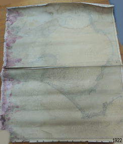
Document - Chart, Admiralty Office, Port Phillip, 1899
Accurate charts were imperative for sea farers to sail their vessels safely from one side of the world to another. The British Admiralty published many charts and updated them frequently. Specialists were employed to gather information such as depth soundings to give the navigator as many helps as possible. At regular intervals the charts had to be updated with the amount of adjustment needed to a compass to allow for magnetic variation.This chart is significant for its association with incoming and outgoin ships for trade and passengers in the late 19th century.Admiralty Chart of Port Phillip, Victoria, South Coast of Australia. It shows navigation buoys, lighthouses, tides and money other details. It was surveyed by Commander Henry L. Cox R.N. in 1864. Published by Admiralty August 19th 1865. Corrections were made by Staff Commander E.J. Stanley R.N. in 1874. The West Channel was surveyed b J.B. Mason , Engineer, in 1899. Published and cartographed in Admiralty, London, England in 1897, supervised by Capt G H Richards R N Hydrographer. Chart was updated in 1899. Sold by W D Potter Agent for Admiralty Charts 145 minorities.Printed: "Port Phillip" "Australia - South Coast, Victoria"flagstaff hill, warrnambool, maritime-museum, flagstaff hill maritime museum & village, shipwreck coast, chart, australia, south coast, port phillip, admiralty, 1899, navigation, cartography, cartographer -
 Royal Brighton Yacht Club
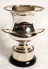
Cup, Alan Robinson Memorial Trophy (Cup)
Alan Robinson Memorial Trophy (Cup) Donor : Keith Farfor Deed of Gift: No Alan Robinson was the navigator on Keith Farfor’s yacht Super Star. He was killed in a car accident on the banks of the Yarra River. The race is a combined division race from RBYC to the QCYC. The trophy is awarded to the PHD handicap winner and is raced early June of each year. First Winner: Bindi D Buxton alan robinson, memorial, trophy, phd, combined division -
 Marysville & District Historical Society
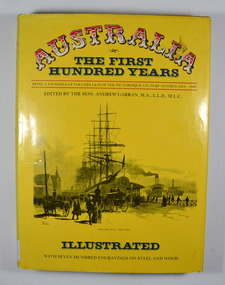
Book, IPC Books Pty Limited, Australia-The First Hundred Years-Being a facsimile of Volumes I & II of the Picturesque Atlas of Australia-1888, 1886
The Picturesque Atlas was designed to give a graphic and summarised conception of Australasian history and life from the days of the earliest Portuguese, Spanish, Dutch, English and French navigators to the 1880's, embracing such salient events as the landing of Captain Cook in 1770. the discoveries of voyagers, explorers an pioneer missionaries; the founding of the different colonies; the establishment of representative government and the marvellous political, commercial and social development which characterises the people of Australia.Dust cover has an illustration depicting Circular Quay, West Side in the early days of Australia.non-fictionThe Picturesque Atlas was designed to give a graphic and summarised conception of Australasian history and life from the days of the earliest Portuguese, Spanish, Dutch, English and French navigators to the 1880's, embracing such salient events as the landing of Captain Cook in 1770. the discoveries of voyagers, explorers an pioneer missionaries; the founding of the different colonies; the establishment of representative government and the marvellous political, commercial and social development which characterises the people of Australia.history, australia, explorers, voyagers, missionaries, politics, commercial development, social development -
 Melbourne Legacy
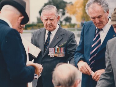
Photograph, Anzac commemoration for students 1987, 1987
Photo of Legatee Ian Richardson at the students Anzac commemoration ceremony on 28 April 1987. His medals include the Distinguished Flying Cross and the Distinguished Flying Medal. He appears to be holding a tray of rosemary that Legacy Widows prepare for Anzac Day services. Was found in an envelope marked "For Melbourne Legacy. Anzac Day Parade featuring Legacy Lads.' From TROVE: an article from June 1944 mentions him receiving his DFM for 'SKILL AND COURAGE Flying-Officer Richardson, a navigator, has completed a second operational tour. He is an exceptional navigator, whose skill and coolness in time of stress have inspired confidence among his crew.' According to Forces War Records UK, the Distinguished Flying Cross (DFC) is awarded to Officers and Warrant officers for "an act or acts of valour and courage or devotion to duty performed whilst flying in active operations against the enemy". The Distinguished Flying Medal was the other ranks' equivalent to the Distinguished Flying Cross.A record of Legatees attending the student ceremony that was held just prior to Anzac Day. Also that their medals show a history of distinguished service.Photo of Ian Richardson at the students Anzac ceremony in 1987.Handwritten on the back 'Ian Richardson, Legacy Shrine Ceremony for children 28.4.87 DFC, DFM' in black pen.anzac commemoration for students, legatee, ian richardson -
 National Vietnam Veterans Museum (NVVM)
Photograph, 1/04/1969 12:00:00 AM
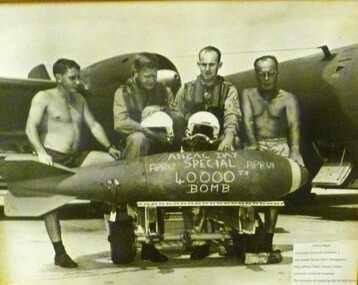
Black and white photograph of 4 RAAF airmen standing behind a bomb: two on either side are shirtless, two in middle wear flying suits and hold helmets. Anzac Day Special 750-pounder, the 40000th bomb in 2 years of 2 Squadron. Pictured left to right are Leading Aircraftman Ian Senini (/Armourer), Squadron Leader Bruce Hunt (Navigator), Flying Officer Peter Salvair (Pilot), Sgt Ronald O'Neill (Armament Fitter). Flying Officer Salvair competed 241 missions in 11 months. Anzac Day Special Apr 69. 40,000th Bombphotograph, bomb -
 Halls Gap & Grampians Historical Society
Document - Fax of article (magazine/newspaper)
The article is c.1993. Chautauqua peak is named after the Chautauquans, who held summer camps in Halls Gap in the 1890s. NOTE: Additional images are second and third pages, and a Microsoft Word file which includes the text of all three pages. A PDF file of an "augmented copy of the fax (with the more difficult to read sections clarified in pencil) is also available in the \Pictures\MP Navigator\2009_09_-02 directory on the computer (as there is not further space to attach it to this record)A copy of a three page National Geographic Traveler article entitled 'An enduring tradition'. The article describes the reporter's trip to Lake Chautauqua where the Chautauqua Institution was founded, and includes historical information about the Chautauquans.Chautauqua written in ball-point pen on top of front page.media, magazine articles -
 Bendigo Military Museum
Memorabilia - PHOTOGRAPH & SOUVENIR, C.1943 - 45
Item re Allan Frederick Goodall DFC, RAAF, refer Cat No 543.2 for his service details. These items were in a wallet, refer Cat No 5772 for the story and connection. This would be a multi Commonwealth Aircrew. Crew members were L to R, Bill Jones, Tony White, Nobby Norris, Doug Eden, Peter Ellis, Alan Goodall..1) B & W photo of a Wellington Bomber in the rear with six Aircrew in Flying gear standing in front. Inscription on rear in faint black pen. .2) Handkerchief with hand painted scene of Mt Etna in Sicily.On Rear , "left to right, F/Sgt Bill Jones (Gunner), F/Sgt Tony White (Bomb aimer), F/Sgt Nobby Norris ? (W/Op 2nd), F/Lt Doug Egan (Pilot), F/O Peter Ellis (Navigator), F/O Allan Goodall (1st W/Op)"photographs, souvenirs, memorabilia, dfc -
 Nhill Aviation Heritage Centre
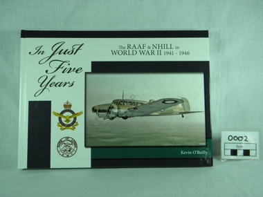
Book, K. O'Reilly, In Just Five Years - 1941 to 1946, Published 2009
Hardback,history of the RAAF & Nhill in World War II 1941 - 1946, written by Kevin O'Reilly. Front coloured white & blue, photo of Avro Anson Mk1 on front, with emblems of RAAF and Shire of Lowan. Reverse in simlilar colours, with cartoons and 8 small photos. Preface by Chris G Spence AO, Air Vice Marshal (Retd).history world war ii, raaf base nhill, 1941 1946, kevin o reilly, john clarkson, peter isaccson wing commander retd am dfc afc dfm, chris, spence, air vice marshal retd -
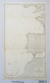 Flagstaff Hill Maritime Museum and Village
Document - Navigation Chart, Portsmouth to Canary Islands, Ca. 1928
This is an Official British Admiralty Navigation Chart, one of a set of 65 charts donated together with a wooden chart case. It was published and printed in London in 1928 by the British Admiralty. Navigation charts are drawn by professional hydrographers and describe the geography of land and water, enabling a water based navigator on board vessels such as ships to safely negotiate between ports locally and around the world. They are drawn to a particular standard with common symbols noting landmarks. The charts are used in conjunction with other navigational instruments and tools to calculate the vessel’s exact location and a safe route to its destination.The set of charts and their chart are of significance as examples of equipment and documents used to navigate the oceans of the world, particularly to Australia. Migration to Australia is an important part of this country's history.British Admiralty Navigation Chart - Portsmouth to Canary Islands - printed on rectangular white paper. Published in London by the British Admiralty in 1928.warrnambool, shipwreck coast, flagstaff hill, flagstaff hill maritime museum, flagstaff hill maritime village, chart, map, navigate, navigation, location, vessel, 1928, british admiralty, hydrographer, geography, admiralty chart, portsmouth, canary islands -
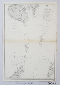 Flagstaff Hill Maritime Museum and Village
Document - Navigation Chart, Eastern Part of the Celebes Sea, Ca. 1928
This is an Official British Admiralty Navigation Chart, one of a set of 65 charts donated together with a wooden chart case. It was published and printed in London in 1928 by the British Admiralty. Navigation charts are drawn by professional hydrographers and describe the geography of land and water, enabling a water based navigator on board vessels such as ships to safely negotiate between ports locally and around the world. They are drawn to a particular standard with common symbols noting landmarks. The charts are used in conjunction with other navigational instruments and tools to calculate the vessel’s exact location and a safe route to its destination.The set of charts and their chart are of significance as examples of equipment and documents used to navigate the oceans of the world, particularly to Australia. Migration to Australia is an important part of this country's history.British Admiralty Navigation Chart - Eastern Part of the Celebes Sea - printed on rectangular white paper. Published in London by the British Admiralty in 1928.warrnambool, shipwreck coast, flagstaff hill, flagstaff hill maritime museum, flagstaff hill maritime village, chart, map, navigate, navigation, location, vessel, 1928, british admiralty, hydrographer, geography, admiralty chart, celebes sea -
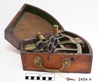 Flagstaff Hill Maritime Museum and Village
Octant, Mid to late 19th Century
An octant is an astronomical instrument used in measuring the angles of heavenly bodies such as the sun, moon and stars at sea in relation to the horizon. This measurement could then be used to calculate the altitude of the body measured, and then the latitude at sea could also be calculated. The angle of the arms of an octant is 45 degrees, or 1/8 of a circle, which gives the instrument its name. Two men independently developed the octant around 1730: John Hadley (1682–1744), an English mathematician, and Thomas Godfrey (1704–1749), a glazier in Philadelphia. While both have a legitimate and equal claim to the invention, Hadley generally gets the greater share of the credit. This reflects the central role that London and the Royal Society played in the history of scientific instruments in the eighteenth and nineteenth century's. There were also two others who are attributed to having created octanes during this period, Caleb Smith, an English insurance broker with a strong interest in astronomy (in 1734), and Jean-Paul Fouchy, a mathematics professor and astronomer in France (in 1732) In 1767 the first edition of the Nautical Almanac tabulated lunar distances, enabling navigators to find the current time from the angle between the sun and the moon. This angle is sometimes larger than 90°, and thus not possible to measure with an octant. For that reason, Admiral John Campbell, who conducted shipboard experiments with the lunar distance method, suggested a larger instrument and the sextant was developed. From that time onward, the sextant was the instrument that experienced significant development and improvements and was the instrument of choice for naval navigators. The octant continued to be produced well into the 19th century, though it was generally a less accurate and less expensive instrument. The lower price of the octant, including versions without a telescope, made it a practical instrument for ships in the merchant and fishing fleets. One common practice among navigators up to the late nineteenth century was to use both a sextant and an octant. The sextant was used with great care and only for lunar sightings while the octant was used for routine meridional altitude measurements of the sun every day. This protected the very accurate and pricier sextant while using the more affordable octant for general use where it performs well. The invention of the octant was a significant step in providing accuracy of a sailors latitude position at sea and his vessels distance from land when taking sightings of land-based landmarks.Octant with metal handle, three different colored shades are attached, in wooden wedge-shaped box lined with green felt. Key is attached. Two telescope eyepieces are in box. Some parts are missing. Oval ink stamp inside lid of box, scale is graduated to 45 degrees. Ink stamp inside lid of box "SHIPLOVERS SOCIETY OF VICTORIA. LIBRARY"instrument, flagstaff hill, warrnambool, shipwrecked coast, flagstaff hill maritime museum, maritime museum, shipwreck coast, flagstaff hill maritime village, great ocean road, octant, navigation, nautical instrument, navigation instrument, john hadley, sextant, astronomical instrument -
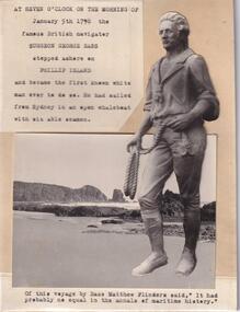 Phillip Island and District Historical Society Inc.
Photograph - Black and White Photograph, Surgeon George Bass
One of a collection of photographs donated by Mr J. W. Gliddon and used in his book "Phillip Island in Picture and Story"Photograph of Surgeon George Bass who came ashore on Phillip Island on the morning of January 5th 1798At seven o'clock on the morning of January 5th 1798 the famous British navigator Surgeon George Bass stepped ashore on Phillip Island and became the first known white man ever to do so. He had sailed from Sydney in an open whaleboat with six able seamen. Of this voyage by Bass, Matthew Flinders said, "It had probably no equal in the annals of maritime history." -
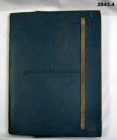 Bendigo Military Museum
Administrative record - FOLDER, 2) & .3) Geographical Section, General Staff, No 4080 War Office 1941 et al, Navigator's Log Book, 2) & .3) 1941
.1) Navigator's Log Book, hard cover, blue colour buckram with dark blue paint on front cover. Back end paper includes a pocket for maps & has a Conversion Table & Nautical Miles, Statute Miles, Kilometres, tables in black print on beige paper included. Stiff card divider. .2) Map folded, black printing on beige paper. Gibraltar Scale 1:1,000,000 at 56 degrees N. .3) Map folded, black printing on beige paper. Algeria Scale 1:1,000,000 at 56 degrees N. .4) Pencil grey lead, timber colour. Stamped into pencil: HB Commonwealth of Australia..1) Hand written in black ink on front end paper: Wreck at Cape Juby. In pencil: S2 / MZ / W2 / 1Z . 35N .2) Hand written in blue pencil: Atlantic. Blue & red ink & lead pencil notations over map. .3) Hand written in blue pencil: Mediterranean. Blue & red ink numerous notations over map.documents - maps/records, military history, passchendaele barracks trust -
 Melbourne Legacy
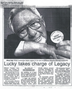
Newspaper - Document, article, Lucky takes charge of Legacy, 1997
An article from the Herald Sun on March 24, 1997. It tells how Brian 'Lucky' Luscombe is taking over as president of Legacy. It gives some biographical details. Including that he was a former president of Clayton RSL, and that he served in World War II as a navigator with 463 RAAF Lancaster squadron and flew missions including the raid over Dresden. His nickname 'Lucky' came after a near miss during training in Tasmania when his plane came close to crashing and somebody said 'Here comes Lucky Luscombe' and the name stuck. It also says Legacy were approaching their 75th Anniversary and were currently caring for 120,00 widows around Australia. It is a nice introduction to the man taking over as President in 1997. Until 2004 a Legatee would only serve as President for a one year term, starting each March.A record that the changes at Legacy were published in the newspapers, both to inform the public and also promote recognition of Legacy's work.Newspaper article with a black and white photo of a Brian Luscombe.past presidents, lucky luscombe -
 St Kilda Historical Society
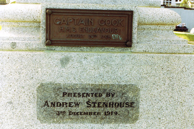
Photograph, Captain James Cook statue, St Kilda - images collection, Photographs taken c 1991 (set)
Statue presented by Andrew Stenhouse, 3 December 1914. Donated by Mr Andrew Stenhouse, a retired contractor who lived at Beaconsfield Parade, St Kilda, he was interested in the reclamation of the foreshore in front of his dwelling Captain James Cook FRS (1728-1779) was a British explorer, navigator, cartographer, and captain in the Royal Navy. During three voyages to the Pacific Ocean he achieved the first recorded European contact with the eastern coastline of Australia and the Hawaiian Islands, and the first recorded circumnavigation of New Zealand. He was killed in the Hawaiian Islands in 1779. The statue appears to have been the first monument erected to him in Victoria and is a replica of one in Whitby, England. It was unveiled on Monday December 7th, 1914 by the Governor of Victoria, Sir Arthur Stanley in front of Commonwealth and State dignitaries and hundreds of St Kilda residents. It was donated by philanthropist Mr. Andrew Stenhouse, a member of the St. Kilda Shore committee.colour photograph unmountedCaptain Cook HMS Endeavour, August 26, 1768. Presented by Andrew Stenhouse, 3rd December 1914. A plaque on the rear of the pedestal (no image provided) lists the crew of the Endeavour. st kilda, captain cook, plaques, catani gardens, captain cook statue, andrew stenhouse -
 Uniting Church Archives - Synod of Victoria
Photograph, Undated, c. 1970s
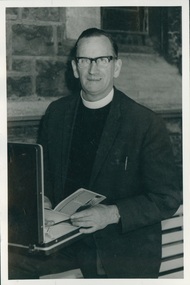
Born on the West Coast of Tasmania. Became a teacher inTasmania in the early 1930. He married Emily Ferguson, a presbyterian girl, but felt a calling to the Methodist Church. John went to Underbool in Vic in 1939. Joined the RAAF in 1942 and trained as a Navigator for Bomber Command. Was recalled in 1943 and began his ministry in the Woomelang Circuit, then at Mitiamo 1947-1950; Port Fairy 1950-52; Nathalia 1952-54. He left the ministry and bought a small farm near Bendigo. After 18 mths he started preaching at Mckenzie Street Methodist church with the title Pastor. In 1958 he was recalled to the ministry and served at Morwell. He was also chaplain to Morwell River Prison, Newport West, Coburg, Milan Italy and Finally at Moonee Ponds where he retired in 1978. After retirement he did supply work in places such as Sea Lake, Heathcote, Warragul and Quirindi NSW. John died on 25 July 2000. B & W photograph of Rev. John Adamthwaite standing in front of an open briefcase.john adamthwaite, methodist, minister -
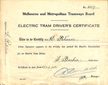 Melbourne Tram Museum
Photograph - Digital Image, Cheryl Williams, "Electric Tram Driver's Certificate No. 407", Original 1929
Digital image of "Electric Tram Driver's Certificate No. 407", issued to D. (Daniel) Patience, signed by G. Barker Instructor, with "A. W. Murdoch" stamp authorising the document, dated 23/3/1929. Donated by Betty (daughter - aged 90) and Cheryl Williams (grand daughter) of Daniel. Reported to have been the first driver leaving the then new Camberwell depot. Born in Avoch Scotland, was a police constable there, before emigrating to Melbourne. Was a cable tram Gripman in the Albert Park Area. Became an electric tram driver, then signalman at St Kilda Junction and trained as an inspector, but did not like the green uniform. Ran in the Stawell Gift of 1925 (injured foot during the race), was a Navigator on Transport RAF/RAAF flights during WW2. War memorabilia to the War Memorial Canberra. Cheryl advised 26/11/2019 - My grandfather was born 2nd June 1903 and died 11th Nov 1977.trams, tramways, drivers, gripmen, camberwell depot, signalmen, certificates -
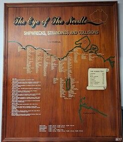 Flagstaff Hill Maritime Museum and Village
Artwork, other - Shipwreck Board, The Eye of the Needle: Shipwrecks, Stranding's and Collisions, ca 2002
The Shipwreck Board is a feature of Flagstaff Hill Maritime Museum and Village/ its subject is explained briefly in the Museum's handbook, The Flagstaff Hill Navigator, published in 2008: - "Known as the ‘Eye of the Needle’ the treacherous entrance to Bass Strait is littered with the wreckage of large international vessels and smaller sail and steam craft used in coastal trade. The vessels bringing emigrants and cargo to Australia found the western entrance to Bass Strait the most dangerous part of their voyage. They had to thread their way between the southern point of Victoria (Cape Otway) and the northern point of King Island, a stretch of water less than 90 km wide. Many smaller coastal vessels were lost at Portland, Port Fairy, Warrnambool and Apollo Bay which are not safe harbours in certain weather conditions. "The Shipwreck Board shows shipwrecks, strandings and collisions which occurred in this area up to the year 1940. Wrecks are identified by a yellow light and collisions/strandings by a green light. These lights also identify the decade the wreck occurred by lighting up when the relevant decade button is pushed. Interesting happenings of the decades are listed next to the buttons." The Shipwreck Board's demonstration of The Eye of the Needle is an interactive visual display that helps teach the perils and dangers faced by early settlers in Victoria. It tells of the vast number of lives lost. It lists the names of many infamous shipwrecks and significant events.The large stained and lacquered timber board is mounted in a timber, frame. It is painted with a small sketch of Australia, and an enlarged outline of the southern coast of Victoria, King Island and the North West coast of Tasmania. The interactive display highlights the shipwrecks, standings and collisions suffered by many vessels as they navigated the 'Eye of the Needle', a narrow stretch of Bass Strait. The locations of the Lighthouses are pinpointed. Lists of groups of ships are below the coastlines. A painted scroll shows eight major shipwrecks with the number of lives lost for each one. A table shows historical facts associated with the decades from pre-1830 to 1940. A system of coloured lights compares the decades with the vessels that suffered damage. The board was created by artist and signwriter, Alex O'Flynn Computer Signs.flagstaff hill, maritime museum, maritime village, shipwreck coast, eye of the needle, shipwreck locations, bass strait, basses strait, king island, north west tasmania, south coast of victoria, cape otway, victorian lighthouse, king island lighthouse, strandings, coastal tracers, emigrant ships, sea trade, 1930s-1940s, shipwreck board, the eye of the needle, collosions, alex o'flynn, alex o’flynn computer signs, shipwrecks of western victoria -
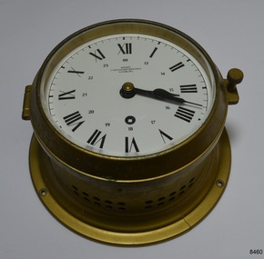 Flagstaff Hill Maritime Museum and Village
Instrument - Chronometer or Marine Clock
This chronometer was made around 1936 and has been on display at Flagstaff Hill for over 40 years as part of the exhibit of the ‘Reginald M’, an Australian-built, 19ss, coastal trader vessel. A chronometer is an accurate mechanical instrument used for measuring time. It is constructed carefully to remain stable even under the changing conditions of seafaring life such as temperature, humidity and air pressure. The Master or Navigator of a ship could use the chronometer and the positions of celestial bodies to calculate the ship’s latitude at sea. In 1905 the business Chronometerwerke GmbH was formed in Frankfurt, Germany, to supply the country with high-quality mechanical chronometers and ship clocks for their maritime trade, making the country independent of other international suppliers such as those in England. In 1938 the firm was renamed Wempe Chronometerwerke. The business continues today. Its products now include its well-known chronometers, battery-powered ship clocks, ship’s bell clocks, barometers, barographs, thermometers, hygrometers, comfort meters to measure temperature and humidity, and wristwatches. The company also performs chronometer testing facilities for the State’s Weights and Measures office. The article written by Givi in July 2022 “The Basics of Marine Meteorology – a Guide for Seafarers” refers to the weather’s signs and patterns being repeated over and over, and the recording of these observations helps forecasters predict changes in the weather. The chronometer is an example of a mechanical navigational marine instrument in use in the early to the mid-20th century. The maker is significant as part of a German government initiative to be self-sufficient in the production of good quality marine technology. This chronometer is significant as part of the exhibit, the Australian-built vessel, 1922 coastal trader ‘Reginald M’, listed on the Australian Register of Historic Vessels and on display for over 40 years.Marine chronometer or marine clock, brass case, glass cover, Roman numerals, 24-hour numbers beside them. Two black hands, a keyhole for winding and ventilation holes in the side. The base has a collar with four machined mounting holes. Inscriptions are on the clock’s face."Made in Germany" and "WEMPE / CHRONOMETERWERKE / HAMBURG"flagstaff hill, flagstaff hill maritime museum and village, warrnambool, maritime museum, maritime village, great ocean road, shipwreck coast, marine meteorology, horology, chronometer, marine technology, latitude, marine navigation, mechanical instrument, scientific instrument, ship clock, chromometerwerke gmbh, wempe chronometerwerke, marine clock -
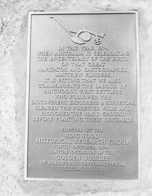 Ringwood and District Historical Society
Photograph, Plaque, Ringwood Library, commemorating Golden Jubilee of Ringwood's severance from Lilydale Shire. 1974
Black and white photograph of plaque set in rock outside Library.Plaque reads: IN THIS YEAR, 1974, WHEN AUSTRALIA IS CELEBRATING THE BI-CENTENARY OF THE BIRTH OF THAT GREAT NAVIGATOR AND CARTOGRAPHER, MATTHEW FLINDERS, IT IS FITTING THAT WE ALSO COMMEMORATE THE LABOUR OF RINGWOOD'S FIRST SETTLERS WHO FOLLOWED THE DISCOVERERS, EXPLORERS & SURVEYORS, CLEARED THE FORESTED HILLS AND PLOUGHED THE HARD GROUND BEFORE PLANTING THEIR ORCHARDS. ERECTED BY THE RINGWOOD HISTORICAL RESEARCH GROUP, 26TH OCTOBER, 1974 ON THE OCCASION OF THE GOLDEN JUBILEE OF RINGWOOD'S SEVERANCE FROM LILYDALE SHIRE Typed below photograph: "1974 - Plaque Ringwood Library." Written on rear of backing sheet: "Before the plaque was finally fitted in I had a new 1974 ten cent piece slipped in behind it. R. Pullin, Archivist, RHR Group." -
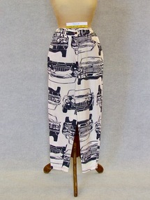 Brighton Historical Society
Trousers, Howard Showers, "Howard Showers" trousers, c1990s
This item is part of the Di Reidie collection. Diane Reidie was a much loved volunteer and President of Brighton Historical Society from 1999 until 2016. Originally from New Zealand, Di and her family lived in Male Street, Brighton for many years. A vibrant and energetic person with a zest for life and a gift for bringing people together, Di was a friend to many in the Bayside community and active in local community organisations. Her tireless work as President of BHS saw her named Bayside Citizen of the Year in 2008. As a seller and collector of vintage clothing, she was passionate about fashion history; one of her many enduring contributions to BHS was her extensive work in preserving, developing and promoting the Society's costume collection. In 2018-19, Di donated more than one hundred items from her personal vintage clothing collection to the Society. The collection, which includes clothing, hats, handbags and shoes from local and international designers, is representative of Di's wide-ranging interests, colourful personality, creativity, humour and love of fashion and travel. Di wore these novelty car print "Howard Showers" pants to many car rally events in Victoria, Australia and USA between 1990 and 2010, where she would perform the role of navigator and co-driver in a team with her husband David. Di's choice of clothing at the rallies is indicative of her sense of humour and attitude towards clothing. Cream coloured cotton French terry cloth pants with metal zip fly front, branded button closure, feature red stitching and printed cars in black ink. There are several car designs featured with each design appearing c1960s - 1970s. One car design features the name "Howard" on its number plate. Manufacturers label "Howard Showers, Holiday, size 12" Metal button inscription "Howard Showers, Syd (Sydney), Aust (Australia). "Made in Australia". Care label. howard showers, novelty print clothing, 1990s, di reidie -
 Flagstaff Hill Maritime Museum and Village
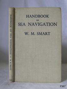
Book - Reference guide, William Marshall Smart (W M Smart), Professor of Astronomy, A Handbook of Sea Navigation, 1943
Author W M Smart, M.A., D.SC., F.R.A.S. (William Marshall Smart), (1889-1975) Regius Professor of Astronomy in the University of Glasgow, Instructor-Lieut. in the Royal Navy during World War I. and John Couch Adams Astronomer in the University of Cambridge. In 1943 he was elected as a fellow of the Royal Society of Edinburg. From 1949-1951 he was President of the Royal Astronomical Society and a member of the Royal Institute of Navigation. In 1958 he was awarded the Lorimer Medal of the Astronomical Society of Edinburgh. The publisher firm, Longmans, Green & Co, was originally founded in 1724 in London by Thomas Longman under the name Longman. In August of that year, he bought the two shops and goods of William Taylor and set up his publishing house there at 39 Paternoster Row. The shops were called Black Swan and Ship, and it is said that the 'ship' sign was the inspiration for Longman's Logo. After many changes of name and management, the firm was incorporated in 1926 as Longmans, Green & Co. Pty Ltd. The firm was acquired by Pearson in 1968 and was known as Pearson Longman or Pearson PLC. The book was sold by Collins Book Depot which was founded by Frederick Henry (Harry) Slamen in 1922. In 1929 the form became a Proprietary Limited Company with an additional two stores, at 95 Elizabeth and 361 Swanston Streets, Melbourne. Collins Booksellers is still owned by the Stamen family. It is the largest Australian-owned bookselling chain.The book is significant due to its connection with navigation at sea. Its author W M Smart was a learned astronomer and an Instructor-Lieutenant for the Royal Navy during World War I. His achievements were recognised in 1958 when he was awarded the Lorimer Medal of the Astronomical Society of Edinburgh.A Handbook of Sea Navigation: The Theory & Practice of Astronomical Navigation at Sea, with diagrams and charts Author: W M Smart, M.A., D.SC., F.R.A.S. (William Marshall Smart) Publisher: Longmans, Green and Co Printer: Collins Book Depot Date: 1943 Textured green hardcover book. Inscriptions on the Fly page.Pencil: "12/6" [12 shillings 6 pence] Sticker: "G.F. Byrne / Faunce Crescent / O'Connor, A.C.T. / Australia 2001" Stamp: "COLLINS BOOK DEPOT PTY. LTD. / Technical Book Department / 361 Swanston St., Melb. G - - -"flagstaff hill, flagstaff hill maritime museum and village, warrnambool, maritime museum, maritime village, great ocean road, shipwreck coast, longmans green and co., thomas longman, paternoster row london, w m smart, william marshall smart, astronomer, navigator, professor of astronomy, 1943, g.f. byrne, collins book depot, technical book department, 361 swanston st., melbourne, frederick henry (harry) slamen, 361 swanston street melbourne, a handbook of sea navigation, maritime handbook, navigation instructiono, sea navigation -
 Bendigo Military Museum
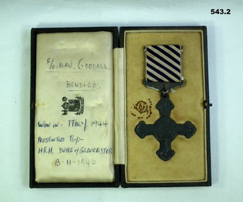
Award - MEDAL DFC, C.1944 - 46
Allan Frederick GOODALL DFC. Allan enlisted in the RAAF on 10.10.1941 No 409828 age 18 years. He was mustered as Aircrew on elisted and was designated as WO/AG ( Wireless operator Air Gunner) on 23.7.1942. he rose through the ranks from AC2, LAC, Sgt, F/Sgt, W/O, F/O to Flt/Lt on 1.3.1945. Embarked for England on 24.8.1942 and posted to RAF Station Bournemouth on 18 .11.1942, posted to MEC (Middle East Command) with 150 Sqd RAF flying Wellingtons from North Africa. On 21.12.1943 on a non operational flight from Africa to Italy his flight crashed into Mt Etna, they were coming out of a cloud when the Pilot saw Etna. Allan as least injured made sure his mates were okay and sheltered he walked down to a nearby village (Maletto) to get help. Allan spent from 21.12.1943 to 5.1.1944 in hospital with Abrasions. He was awarded the DFC (Distinguished Flying Cross) in 1944 for operations over Italy, at the time he was classed as Sqd Signals Leader. According to his records he flew 37 Operational sorties. He was discharged from the RAAF on 3.1.1946. The crew of the Plane were; Bruce Hayman (NZ) Pilot, Fractured leg. Allan Goodall Aust (WOP/AG) abrasions and injured wrist. Alan Warner (Aust) Navigator, Fractured Ankle. Y.F.Redknap (UK) injured shoulder. C.A. Carr (UK) Fractured Dorsal Spine. J.E. Ward (UK) Dislocated shoulder. Alfred Dugdale (UK) Deceased. Tony Moore (UK) Deceased. Both are buried at the Catania War Cemetery Sicily. Refer Cat No 1025P for his photo.543.1 Medal-Distinguished FLying Cross won by FO Alan F Goodall. Rear of medal is engraved "Italy FO Alan Goodall 1944" 543.2 Case-to suit DFC above. Case rear has a note "Alan's sister Jean, Mrs R.T Mitchell, 22 O'Dea Cres Kangaroo Flat 3555 471428." Written inside case in pen "F/O Alan Goodall Bendigo Won in Italy 1944 Presented by HRH Duke of Gloucester 13-11-1946"awards, dfc ww2, raaf -
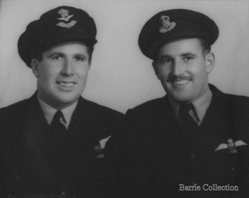 Melton City Libraries
Photograph, Jim (James) and William (Horace) Barrie, Unknown, c.1940
In 1939 when World War 11 erupted Jim and Horace enlisted in the RAAF Jim to become a pilot and Horace a navigator. James Edward Barrie enlisted in the RAAF on 21st June 1941, aged 19 years. He was sent to Canada and then later to England to become a Spitfire Pilot. Half way through the War he returned to Australia to be sent north to fight the Japanese. At one stage he had to bail out over the Pacific after his engine had failed. Fortunately, he had time to radio his position before he abandoned his Spitfire. He dropped his boot out to determine how far below the water was, parachuted down inflated his dinghy and waited to be rescued. He was picked up very quickly by a rescue crew just as a heavy fog descended, or he may never have been found. He lost many of his mates in that Squadron in the Pacific, it was a particularly vital time for the Allies and these boys played a major part in turning the tide against the Japanese. This information has been taken from the writings of Mary Robinson, sister of Jim. My parents Bon and Edna Barrie spoke about this incident leaving a vivid impression in my mind as a young child. Jim is mentioned in the book Two Steps to Tokyo. A Story of the RAAF in the Trobriand and Admiralty Islands by Gordon Powell Chaplain, RAAF. After the war Jim returned to Darlingsford. In 1953 he married Wilma Ryan of Yarram. He continued in the family farming tradition obtaining a Soldier Settlement Block at Shelford. Jim regularly attended the ANZAC day march to the Shrine. He died in August 2004 This account has been compiled by his niece Wendy Barrie Sons of Charles (Ernie) and Jessie Barrie of Darlingsford Meltonlocal identities -
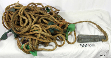 Flagstaff Hill Maritime Museum and Village
Equipment - Lead line
The lead line or hand lead is a simple navigational instrument used as a depth finder to measure the depth of water under the ship’s keel and to take samples of the sea bed. The long line may be marked at regular intervals with tags of different coloured and textured fabric, such as rope, leather and cloth. Each tag was a code to represent a certain depth. The leadsman’s eyes and hands could distinguish the depth easily as he drew in the lead line, day or night and in poor weather conditions. A standard set of codes for the tags was used so that the depth of the sea could be easily and quickly read. The measurement used was a Fathom, which equals 1.83 metres. The codes were: - 2 fathoms = 2 strips of leather 3 fathoms = 3 strips of leather 5 fathoms = white duck fabric 7 fathoms = red bunting fabric 10 fathoms = leather with a hole 13 fathoms = blue serge fabric 15 fathoms = white duck fabric 17 fathoms = red bunting 20 fathoms = 2 knots The lead weight could be between 7 -14 pounds (3.5 – 6.5kg) and the rope would be approximately 25 fathoms (45m). The hollowed-out end of the weight would hold a stick substance such as tallow or wax, which would pick up samples from the sea bed which would show whether the vessel was close to, or far away from, the shore. The leadsman would stand at the front of the vessel and cast the lead line into the sea. When it hit bottom he would note the tag marker nearest the surface of the water and call out his finding. Then he would haul it up again and examine the kind of matter that adhered to the end of the weight, whether it be sand, mud, gravel, or the colour of it. This information would be given to the ship’s helmsman or navigator and would help indicate the proximity to the land.This handheld lead is an example of early marine navigational equipment used by sailors to travel the seas to measure the depth of the water and sample the nature of the seabed. It helps to understand the history and progress made from the very basic to the sophisticated technology of today.Lead line, sounding line or depth finder. The long length of rope has a heavy lead weight attached to the end. Coloured fabric tags are tied onto the rope at regular intervals, representing different depths. The concave base of weight holds sticky substances such as tallow or beeswax, providing an adhesive surface to collect samples of sea bed like sand, shells or pebbles. flagstaff hill, warrnambool, shipwrecked coast, flagstaff hill maritime museum, maritime museum, shipwreck coast, flagstaff hill maritime village, lead line, depth finder, hand lead, sounding lin, leadsmane, navigation instrument, leadline, hand lead line -
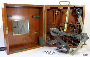 Flagstaff Hill Maritime Museum and Village
Instrument - Navigational Sextant, 1882-1890
A sextant is an astronomical instrument used to determine latitude and longitude at sea by measuring angular distances, especially the altitudes of the sun, moon, and stars. It is a doubly reflecting navigation instrument and used mainly by sailors to measure the angular distance between two visible objects. The name comes from the Latin sextans, or “sixth part of a unit,” because the sextant’s arc can be 60° or 120° of a circle depending on the model used. The primary use was to measure the angle between an astronomical object and the horizon for the purposes of celestial navigation. The estimation of this angle is known as sighting or shooting the object, or taking a sight. This angle and the time when it was measured is used in order to determine Greenwich Mean Time and hence longitude. Sighting the height of a landmark on land can also give a measure of distance from that object. History: The development of the sextant was as an improvement over the octant, an instrument designed to measure one's latitude. The octant was first implemented around 1731-present but can only measure angles up to 45°. As larger angles were needed to allow the measurement of lunar objects - moon, stars and the sun - at higher angles, the octant was superseded by the sextant. The sextant is a similar instrument but better made and allows larger angles from 60° to 120°. This improvement allows distances to be accurately calculated thereby giving longitude when used with a chronometer. The sextant was derived from the octant in 1757, eventually making all previous instruments used for navigational positioning obsolete. The sextant had been attributed to by John Hadley (1682–1744) and Thomas Godfrey (1704–1749), but reference to the sextant was also found later in the unpublished writings of Isaac Newton (1643–1727). Earlier links can be found to Bartholomew Gosnold (1571–1607) indicating that the use of a sextant for nautical navigation predates Hadley's implementation. In 1922, the sextant was modified for aeronautical navigation by Portuguese navigator and naval officer Gago Coutinho. It should be noted that the octant and quadrant are in the same family as they were, and all are, regarded as sextants. The sextant is representative of it's type and although not fully complete it demonstrates how 18th,19th and 20th century mariners determined their latitude and longitudinal to determine their position on a chart, allowing them to navigate there way across the world's oceans. It also demonstrates the skill and workmanship of the early instrument makers that operated scientific instrument businesses from London and other areas of England to provide most of the navigational instrumentation used by commercial and military navies of the time.Sextant with square, fitted box of polished wood, "Hezzanith" brand. Box contains many parts for the sextants use. On certificate "Heath & Co, London. Sextant Number Y 822". Catch on lid "DEFIANT LEVER" and "PATENT NUMBER 187.10". Maker's certificate is attached to the inside of the box.flagstaff hill, warrnambool, shipwrecked-coast, flagstaff-hill, flagstaff-hill-maritime-museum, maritime-museum, shipwreck-coast, flagstaff-hill-maritime-village, sextant box, sextant, hezzanith, heath & co, navigational instrument, george wilson heath, astronomical instrument, instrument manufacturers, scientific instrument, navigation, celestial navigation, octant, quadrant, lunar navigation -
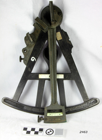 Flagstaff Hill Maritime Museum and Village
Octant, Late 18th to mid-19th century
An Octant is a doubly reflecting navigation instrument used primarily by sailors to measure the angular distance between two visible objects and was a forerunner of the sextant. The name comes from the Latin octo, or “one-eighth of a circle,” for the Octant’s arc which spans 45°, or one-eighth of a circle. The primary use of an Octant is to measure the angle between an astronomical object and the horizon for the purposes of celestial navigation. The estimation of this angle is known as sighting or shooting the object, or taking a sight. The angle, and the time when it was measured, can be used to calculate a position line on a nautical chart (latitude), for example, sighting the Sun at noon or Polaris at night (in the Northern Hemisphere) gives an angle by which the latitude can then be estimated. Sighting the height of a landmark on land can also give a measure of distance. History: The principle of the Octant as an instrument to measure ones latitude was first implemented around 1742-present but was superseded by the improvement of the octant to a sextant, a very similar instrument, better made and able to measure bigger angles 120°, allowing the measurement of Luna distances to give longitude when used with an accurate chronometer. The sextant started to appear around 1730 and had been attributed to by John Hadley (1682–1744) and Thomas Godfrey (1704–1749), but reference to the sextant was also found later in the unpublished writings of Isaac Newton (1643–1727). Earlier links can be found to Bartholomew Gosnold (1571–1607) indicating that the use of a Sextant for nautical navigation predates Hadley's implementation. In 1922, the sextant was modified for aeronautical navigation by Portuguese navigator and naval officer Gago Coutinho. Henry Hemsley was a lesser-known instrument maker and optician working in London in the late 17th and early 18th century. However, it should be noted that there were two Henry Hemsley opticians and instrument makers around this period. (Henry Hemsley 1, 1786-89, who had premises at 85 Fleet St London and Henry Hemsley 2, 1828-56), whose workshop was at 135-138 Radcliff Highway London. Therefore, based on the inscribed workshop address Henry Hemsley 2 is responsible for making this example.The octant is representative of its type and although not fully complete it demonstrates how 18th and 19th-century mariners determined their latitude on a chart to navigate their way across the world's oceans in the 18th and 19th century. It also demonstrates the skill and workmanship of the early instrument makers that operated from London at this time and provided most of the navigational instrumentation use by commercial and military navies of the time.Octant, ebony wooden frame and handle. Scale is missing from recess in frame. "H. Hemsley 135-138 Ratliff Highway, London", no box"H. Hemsley 135-138 Ratcliff Highway, London"flagstaff hill, warrnambool, shipwrecked-coast, flagstaff-hill, flagstaff-hill-maritime-museum, maritime-museum, shipwreck-coast, flagstaff-hill-maritime-village, navigation, navigational instrument, instrument used for navigation, sextant, henry hemsley, instrument maker, london, octant -
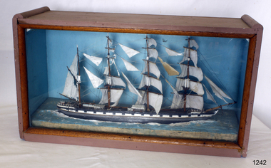 Flagstaff Hill Maritime Museum and Village
Craft - Ship Model, Loch Torridon, Early 20th century
The Loch Torridon was built in response to the need for a large cargo-carrying ship in the 1870s becoming famous for being one of the most per4fect four-masted barques ever built. She was built for the Loch Line in 1880 by Messrs. Barclay, Curle, and Co. Her measurements were 287 feet in length and 42 feet in beam, and 24 feet depth of hold. She was well sparred and her sail plan was so perfectly balanced that she was a very handy ship, easy on her helm, which was not a common virtue amongst large four-masted ships of her day. Her sails were interchangeable on all three masts, which was common in the last days of sail for both economical and practical purposes. The Loch Torridon was considered one of the most graceful and elegant ships ever launched from the Glasgow shipyards. The first master was Captain Pinder, the first cargo was bound for Melbourne Australia, after which she went on to Calcutta with a cargo of horses. On August the 22nd 1882 with a cargo of Jute onboard loaded in Calcutta the Loch Torridon ran into a storm. Sailing in heavy seas the captain, the second mate also the man at the wheel, and a boy was washed overboard with the first mate just escaping the same fate. Captain Pinder and the crew members could not be rescued and were never seen again with the first mate having to bring the ship home. The next Captain was Robert Pattman who was regarded as a fine navigator and seaman who sailed the Loch Torridon for the next twenty-six years and nine months. He had made 25 voyages around the world during this time without any serious mishap. In 1909 Captain Pattman resigned his command of the ship to switch to a steam vessel but unfortunately was injured on his first voyage and had to be landed at Falmouth, he dies of his injuries shortly afterwards. The Loch Torridon kept on sailing until 1915 after having been sold to a Russian company two years earlier. Near the end of January 1915, the ship sprang a leak of the west coast of Ireland and was abandoned sinking shortly afterwards. For further information regards possible maker of the model see Provenance sec this document: The item is of significance as an item made possibly by a man who served on the original ship making the item of historical significance given that the original craft was a well-known and respected trade vessel making voyages between England and Australia as well as the near East. Ship model Loch Torridon 4 masted, hull is black, grey and white. Ship in full sail with 4 lifeboats on deck. Ship sits on textured base. Has plain blue background. Noneflagstaff hill, warrnambool, shipwrecked-coast, flagstaff-hill, flagstaff-hill-maritime-museum, maritime-museum, shipwreck-coast, flagstaff-hill-maritime-village -
 Eltham District Historical Society Inc
Film - Video (DVD), Melbourne and Metropolitan Board of Works, Yarra River Conference Proceedings; a Board of Works centenary event, 13-16 April 1991
Yarra River Conference History Segment [Noted on VHS tape jackets "Due to unavoidable circumstances, the quality of these tapes in some setions is less than desired."] The Yarra River Conference, organised by the Board of Works as part of the Centenary Celebrations, was held in the Board's Head Office Theatrette from 13-16 April, 1991. A segment of the Conference focussed on the role that the Yarra River has played in relation to the historical development of Melbourne. Conceived and presented by a group of prominent historians as a chronological 'trip down the river in time', and profusely illustrated with slides, this segment traced the various impacts that urban and rural growth, development of marine commerce, recreational uses, and environmental problems have had on the Yarra during a century and a half of European occupation. As no formal written paper of this combined presentation is available, these two video-tapes provide a record for anyone who has an interest in tis fascinating aspect of the Yarra's history. The speakers who combined to present this segment are identified on the cover of Tape 2. Tape 1 (2 hours) 1838-1863 Deputy ?? to Utility Early navigators of the Yarra River; developing the port of Melbourne; the gold rush and its effect on the new colony; punts and bridges; water supply; pollution of the Yarra; the discovery of gold and early settlement of the Yarra valley; floods of 1839 and 1863. 1863-1891 Formation of the Harbour Trust; Coode Canal; pollution of the Yarra by industry; aborigines, gold miners, timber getters in the Upper Yarra areas; bridges; the flood of 1891. Tape 2 ( 1 1/2 hours) 1892-1934: People Begin to See Beauty and Romance to the River Henley-on-Yarra; realignment of the Yarra; MMBW is responsible for a sewerage system; new docks to cope with increased overseas trade; development of recreational parks; new reservoirs; timber production and timber tramways; bushfire; flood of 1934. 1935-1970: The River is Neglected Still, Except When it Proves Useful Bushfirs of 1939; the end of many sawmills; birth of tourism; increased interest in conservation and preservation of land for open space; further augmentation of water supply system; birth of containerisation changes the port; environmental concerns gain momentum. Speakers Dr Tony Dingle *, Department of Economic History, Monash University Dr Carolyn Rasmussen *, History Consultant Prof. Graeme Davison, History Department, Monash University Mr. Tom Griffiths, Lecturer in Public History, Monash Uiversity Mr. Patrick Miller, History Consultant Mr. Colin Jones, Author and Historian * Co-authors of the Board's history, 'Vital Connections'.video recording, yarra river, conference proceedings -
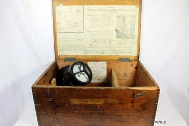 Flagstaff Hill Maritime Museum and Village
Instrument - Ship Log, Early 20th Century
In times past the only way to measure a ship’s speed was to throw a wood log into the water and observe how fast it moved away from the ship. In the 16th century, the log was fastened to a rope knotted at set intervals. The log was thrown over the stern (back) of the vessel and a crew member counted the number of knots that were paid out in a set time. From this, they could estimate the vessel's speed through the water. This was known as streaming the log and is also the derivation of the knot as a measurement of nautical speed. Various manufacturers of nautical equipment had sought over the years to perfect the operation of determining a ship's speed and it wasn't until Thomas Walker and his son Ferdinand developed a mechanical system that eventually made this task became easy for marine navigators. Thomas Walker & Son were internationally renowned in the manufacturing of ship logs the founding father, Thomas Walker (1805–1871), an engineer in Birmingham, patented his mechanical log in 1878 which was a recording instrument that attached to a rail at the stern of a vessel connected by a long cord with a rotor which was towed behind the ship. The instrument dial then recorded the distance travelled. Thomas Walker first went into business to manufacture stoves at 58 Oxford Street Birmingham. Walker’s self-feeding stove was widely lauded at the Paris Exhibition of 1855, winning a prize medal and kickstarting the first of many notable innovations for the Walker family's manufacturing business. However, it wasn’t until working on an earlier ship’s log model invented by his Uncle that Thomas Walker became interested in the further development of this device, used to ascertain a ship’s speed. Walker continued to improve on the common log for the company of Massey & Sons and these improvements were deemed revolutionary. This log became a firm favourite of the West India Association (a British-based organisation promoting ties and trade with the British Caribbean), being the most common log in use for two generations. It took until 1861 for Thomas Walker and his son, Thomas Ferdinand Walker (1831-1921) to patent the first Walker log of many. Together, with the introduction of the A1 Harpoon Log two years later, they established the Walker Log Business as a force to be reckoned with. By his passing in 1871, Thomas Walker Snr had not only founded a family business with considerable staying power but also instilled a tradition of public service. Having sat as a representative on the Birmingham Town Council for 15 years and played an active role in public works, he was soon given the nickname of ‘Blue Brick Walker’. Much like his father, Thomas Ferdinand Walker changed the face of the maritime industry. His patent of 1897, the ‘Cherub’ log, was a notable departure from the past providing a far more accurate reading and replacing the majority of logs of the age. They were the first to produce an electric log (Trident) and the Walker factory was one of the first to introduce the 48-hour work week for employees.The ship log was invented and made by a significant marine instrument maker and innovator of machinery. It demonstrates the huge leap taken to improve navigational accuracy at sea with an instrument that was in use for decades.Ships Log, Walker Trident electric motor, in wooden box with instructions inside box. The motor dial with electric cord is still inside box.Inscription "Admiralty patent number 3332" and "Walker Trident Electric Ship Log (Mark III), 15-25 volt". On top of lid, hand written, is "G TAYLOR"flagstaff hill, warrnambool, shipwrecked-coast, flagstaff-hill, flagstaff-hill-maritime-museum, maritime-museum, shipwreck-coast, flagstaff-hill-maritime-village, ships log, thomas walker & son, electric ships log, marine navigation, thomas ferdinand walker, ship log