Showing 167 items matching "nepean highway"
-
 Glen Eira Historical Society
Letter - Theatres and Cinemas
... Nepean Highway... Elsternwick Hoyts Elsternwick Theatre Esquire Nepean Highway ...This file contains four items relating to research by members of the Caulfield/Glen Eira Historical Society about theatres and cinemas in Glen Eira: 1/A handwritten copy of a letter from the Caulfield Historical Society to the Secretary of Hoyts requesting information about Hoyts cinemas in Glen Huntly, St. Kilda, Caulfield, Carnegie and Elsternwick. Date unknown. 2/A typed list of cinemas in Glen Eira, dated 07/08/2010 giving their location, name, dates of operation and current status. Researcher unknown. 3/Research notes written by Claire Barton, 02/07/2013, paraphrased from ‘The Pictures and Flea Pits: 80 Years of Australians at the Pictures’ by Simon Brand (1983). The notes give the broader context of cinemas in Australia at the time many Glen Eira cinemas were in operation. 4/Research notes written by Claire Barton, 04/07/2013, paraphrased from ‘Moorabbin: A Pictorial History, 1862-1994’, by John Cribbin (1995). The notes give a brief history of the Bentleigh Theatre and Ormond Theatre (renamed ‘The Plaza’).hoyts theatres ltd., gardenvale, mayfair gardenvale, nepean theatre, glen huntly, glen huntly theatre, caulfield, crystal palace theatre, carnegie, hoyts carnegie theatre, elsternwick, hoyts elsternwick theatre, esquire, nepean highway, glenhuntly road, glen huntly road, manchester grove, dandenong road, woorayl street, carre street, gordon street, cinemas, theatres, bentleigh, hoyts bentleigh, caulfield south, camden, carnegie, memorial, rosstown, carnegie theatre, pohebe, renown, elster, esquire, kadima, sharon, classic, rex, argosy, capri, ormond theatre, the plaza, depression 1929-1939, audiences, industry, world war 1939-1945, television broadcasting, drive-in theatres, entertainment, bentleigh theatre, centre road, nicholson street, suburban life, suburbs, community centres, north road, cribben john, brand simon, barton claire, caulfield historical society -
Glen Eira Historical Society
Document - KELLY FAMILY
... Nepean Highway... Veronica Elster Park Elsternwick Kelly John Nepean Highway Golf ...This file contains two items about this family: 1/Printout of a webpage from museumvictoria.com.au entitled ‘Digital Photograph – Man & Woman in Horse Driven Buggy, Elwood Park, circa 1917’. The image is of Matthew and Jeanette Kelly driving a horse drawn buggy in Elwood Park, circa 1917. The content description also mentions that Matthew Kelly was a saddler in his father John Kelly’s saddlery business. 2/Typed sheet entitled ‘Research findings for Matthew Robert Kelly’ dated July 2014 by Margaret Dunbar on behalf of GEHS. It shows information from the Victorian Births, Deaths & Marriages records plus Electoral Rolls between 1909 and 1942 and has three addresses for Matthew Robert Kelly in Elsternwick. Details of other family members included.elwood park, kelly matthew robert, kelly jeanette veronica, elster park, elsternwick, kelly john, nepean highway, golf courses, kelly elizabeth, acreman alice maud mary, sportsgrounds, saddleries, saddlers, telephonist, horse-drawn vehicles, kelly veronica, brady veronica, kelly jeanetta, brady jeanetta, brady nita, kelly alice theresa, kelly james michael, kelly margaret ann, kelly mary elizabeth, kelly catherine agatha, kelly helena alphonsus, kelly alice, kelly matthew patrick, st georges road, point nepean road, cochrane street, parks and reserves -
Glen Eira Historical Society
Newsletter - ROTARY CLUB OF GLEN EIRA
... Nepean Highway... Trams Ripponlea Market Gardens Chinese Community Nepean Highway ...This file contains six items pertaining to the Rotary Club of Glen Eira: 1/The 1996-7 bulletin of the Club. Contains the address and phone number of the Club, a brief history of Glen Eira, a list of the times and locations of the meetings of both the Glen Eira branch and others in Melbourne, and a list of present and past faculty. 2/A typewritten letter, dated 21/03/1997, from Geoff Oscar, former president of the Club, to Mrs. Felicitie Campbell of the Caulfield Historical Society, thanking the latter for an address delivered to the Club on 18/03. 3/Bulletin #38 of the Club, which principally describes a meeting held at 29/04/1997. Features a duty roster, an advance program, a description of a presentation about ANZAC Day to be delivered at the meeting by Ross Bastiaan, a description of a presentation about great cities of the world delivered at the previous meeting by Peter Shellie, a poem about ANZAC Day, notifications of various upcoming events, and an attendance report. Also attached is a an extract from Victorian Railways to ’62 by Leo J. Harrigan describing the history of the Rosstown Railway. 4/Two copies of a booklet announcing the 21st birthday celebration dinner of the Club, to be held on 11/11/2008. Included is the menu, program of events, and a list of past presidents of the Club. 5/A booklet, dated 2009, providing basic information about the Club, including its address, meeting time, contact details, mission statement, faculty, past presidents, calendar and a brief history. 6/A card announcing the 21st Annual Business Person’s Breakfast, to be held at Glen Eira Town Hall on 12/03/2010, featuring David Smorgon as guest speaker.glen eira, rotary club of glen eira, clubs and associations, st. georges road, elsternwick, local history, ricketson henry, watts thomas, architects, ‘glen eira’, mansions, house names, australian general military hospital no. 11, alfred hospital, southern memorial hospital, graham jeremy, james barry, langfelder kurt, fookes marc, asher geoff, süssmann jacques, flores denis, strong john, sylvester bill, oscar geoff, cohen peter, leske john, sharp merv, ray alf, nettelbeck david, sherlock max, rattray john, pollock david, smith barry, harris paul, britten elizabeth, jacobs frank, campbell felicitie mrs., caulfield historical society, scout groups, dover street, north road, trams, ripponlea, market gardens, chinese community, nepean highway, glen eira road, caulfield grammar, horses, edinburgh avenue, bastiaan ross dr., zazryn ben, schwartz roy, nathan vic, stewart ron, sharp hiam, bendel david, steven john, turner brian, shellie peter, warren r., dalidakis g., silvester b., brain judy, stuckey hugh, solomon john, sloman felicity, anzac day, ‘anzac day poem’, stockdale alan, pfau leon, caulfield races, fundraising events, rotary club of caulfield-rosstown, rosstown sugar mill, banners, ‘victorian railways to ‘62’, harrigan leo j., rosstown railway, railways, business and finance, ross william murray, ‘the grange’, caulfield, rosstown junction railway and property co., rosstown railway abandonment act 1916, rosstown, carnegie, rosstown road, festivals and celebrations, kooyong lawn tennis club, food, heuberger david, harambee choir, mcinnes ray archdeacon, muir colin, aarons joseph, nagaoka ryo, miwa takashi, sheezel robert, matheson judy, marks ian, nelson adrian, blode larry, the london tavern, hawthorn road, binstock sam, hill jan, faiman keith, nirens jeff, preston mark, fabian garry, dimand jack, silvester bill, city of glen eira town hall, annual business person’s breakfast, smorgon david -
 City of Moorabbin Historical Society (Operating the Box Cottage Museum)
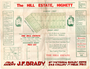
Flyer - Hill Estate, Highett
... Point Nepean Road (Nepean Highway)... of the Municipality of Moorabbin Point Nepean Road (Nepean Highway) Turner ...Land sales in the Municipality of Moorabbin increased when the train line from the City to Frankston was electrified.Example of the progress of the Municipality of MoorabbinAdvertising flyer for auction of real estate sales - plan of building blocks for saleThe Hill Estate, Highett - 24 Housing Blocks - J. F. Bradypoint nepean road (nepean highway), turner street, sanford street, real estate, highett -
 City of Moorabbin Historical Society (Operating the Box Cottage Museum)
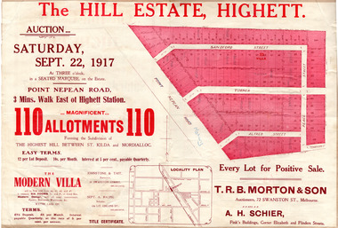
Flyer - The Hill Estate, Highett, 1917
... Point Nepean Road (Nepean Highway)... Point Nepean Road (Nepean Highway) Turner Street Sanford Street ...The land sales in the area stopped due to the 1890s depression. For the next 20 years real estate sales virtually stopped until after WWI.Example of the progress of the Municipality of MoorabbinAdvertising flyer for auction of real estate sales - plan of building blocks for saleThe Hill Estate, Highett - 110 allotments - Auction Saturday September 22, 1917 T.R.B. Morton & Sonpoint nepean road (nepean highway), turner street, sanford street, alfred street, peace street, highett, real estate, moorabbin -
 City of Moorabbin Historical Society (Operating the Box Cottage Museum)
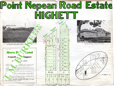
Flyer - Point Nepean Road Estate, Highett, 1937
... Point Nepean Road (Nepean Highway)... of the Municipality of Moorabbin Point Nepean Road (Nepean Highway) Alison ...Land sales in the Municipality of Moorabbin increased when the train line from the City to Frankston was electrified.Example of the progress of the Municipality of MoorabbinAdvertising flyer for auction of real estate sales - plan of building blocks for sale, pictures of landmarks.Point Nepean Road Estate, Highett T.M. Bourkepoint nepean road (nepean highway), alison street, william street -
 City of Moorabbin Historical Society (Operating the Box Cottage Museum)
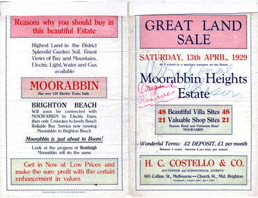
Flyer - Moorabbin Heights Estate, Moorabbin, 1929
... Point Nepean Road (Nepean Highway)... of the progress of the Municipality of Moorabbin Point Nepean Road (Nepean ...The train line from the city to Frankston was electrified which intensified the sale in the municipality of Moorabbin, particularly land which was in the vicinity of the railway stations.Example of the progress of the Municipality of MoorabbinAdvertising flyer for auction of real estate sales - plan of building blocks for saleMoorabbin Heights Estate, Moorabbin 48 Villa sties, 21 Shop sites Sale on Saturday 13 April 1929 - H. C. Costello & CO.point nepean road (nepean highway), harding street, howell street, north avenue, coates street -
 City of Moorabbin Historical Society (Operating the Box Cottage Museum)
Flyer - Pinnacle Estate, Benteligh, 1927
... Pt. Nepean Road (now Nepean Highway)... Road (now Nepean Highway) Vunabere Ave Galtum Ave Tovan-Akas ...The train line from the city to Frankston was electrified in 1922 which intensified the sale in the municipality of Moorabbin, particularly land which was in the vicinity of the railway stations.Example of the progress of the Municipality of MoorabbinAdvertising flyer for auction of real estate sales - plan of building blocks for saleThe Pinnacle Estate, Bentleigh - 53 Home sites & 15 Shop Sites - Auction Saturday March 5, 1927 - Norman D. MacKay and W. Ansteepatterson road, pt. nepean road (now nepean highway), vunabere ave, galtum ave, tovan-akas ave, patterson, bentleigh, auction, real estate -
 City of Moorabbin Historical Society (Operating the Box Cottage Museum)
Plan - Highlands Estate, Moorabbin
... Point Nepean Road (Nepean Highway)... of the progress of the Municipality of Moorabbin Point Nepean Road (Nepean ...The train line from the city to Frankston was electrified in 1922 which intensified the sale in the municipality of Moorabbin, particularly land which was in the vicinity of the railway stations. This estate was auctioned on Saturday, October 20, 1923.Example of the progress of the Municipality of MoorabbinAdvertising flyer for auction of real estate sales - plan of building blocks for saleHighlands Estate, Moorabbin plan.point nepean road (nepean highway), schofield street, taverner street, herbert street (now linton street), moorabbin, real estate, auction -
City of Moorabbin Historical Society (Operating the Box Cottage Museum)
Book - A Journey of Faith - The Stained Glass Windows of St Paul's Bentleigh Holy Trinity Parish, by Patrick Ferry, 2015
... Nepean Highway... of moorabbin market gardeners Nepean Highway St Paul's Catholic Church ...St Paul's Church is in Jasper Road, Benlteigh. A foundation stone reads " This stone symbol of Christ, Chief corner stone of the church was blessed and set by His Grace Archbishop Simonds 13th November 1960, T O'Sullivan P.P. S. J. Morgan and Associates Architect H.P. Yunken Pty Ltd Builder". The stained glass windows were commissioned by Father Timothy O'Sullivan and the artist was Alan Sumner. The window were progressively installed from 1961, and took nearly 20 years to complete.St Paul's Catholic Church Bentleigh was integral to the spiritual well being and social life of the early settlers.A book about the stained glass windows in St Paul's Catholic Church in Jasper Road, Bentleigh - containing photos and diagram.city of moorabbin, county of bourke, shire of moorabbin, market gardeners, nepean highway, st paul's catholic church, bentleigh, jasper road, religion -
City of Moorabbin Historical Society (Operating the Box Cottage Museum)
Booklet - Cheltenham Church of Christ - Our Heritage - The History of the Cheltenham Church of Christ, by K. G. Hilbig and G. L. Daff, 1970
... Nepean Highway... of moorabbin market gardeners Cheltenham Nepean Highway Church ...Cheltenham Church of Christ was opened in 1878 and is still in use today. Built on Chesterville Road, Cheltenham.Cheltenham Church of Christ was opened in 1878 and was integral to the spiritual well being and social life of the early settlers.Booklet 10 pages with typed textearly settlers, parish of moorabbin, city of moorabbin, county of bourke, shire of moorabbin, market gardeners, cheltenham, nepean highway, church of christ cheltenham, religion, chesterville road -
City of Moorabbin Historical Society (Operating the Box Cottage Museum)
Booklet - Souvenir History of the Church of Christ Cheltenham - 80th Anniversary May 2 & 3, 1937, by J. Ernest Allan, 1937
... Nepean Highway... of moorabbin market gardeners Cheltenham Nepean Highway Church ...Cheltenham Church of Christ was opened in 1878 and is still in use today. Built on Chesterville Road, Cheltenham.Cheltenham Church of Christ was opened in 1878 and was integral to the spiritual well being and social life of the early settlers.Booklet 19 pages with typed text and photosearly settlers, parish of moorabbin, city of moorabbin, county of bourke, shire of moorabbin, market gardeners, cheltenham, nepean highway, church of christ cheltenham, religion, chesterville road -
City of Moorabbin Historical Society (Operating the Box Cottage Museum)
Booklet - One Hundred Years - Church of Christ Chesterville Road, Cheltenham 1857-1957, by J. Ernest Allan, 1957
... Nepean Highway... of moorabbin market gardeners Cheltenham Nepean Highway Church ...Cheltenham Church of Christ was opened in 1878 and is still in use today. Built on Chesterville Road, Cheltenham.Cheltenham Church of Christ was opened in 1878 and was integral to the spiritual well being and social life of the early settlers.Booklet 12 pages with typed text and photosearly settlers, parish of moorabbin, city of moorabbin, county of bourke, shire of moorabbin, market gardeners, cheltenham, nepean highway, church of christ cheltenham, religion, chesterville road -
City of Moorabbin Historical Society (Operating the Box Cottage Museum)
Booklet - A History of the Cheltenham Methodist Church, Charman Road 1854 - 1954, by Dr. K. A. Stephenson, 1954
... Nepean Highway... Cheltenham Charman Road Nepean Highway methodist church religion ...Cheltenham Methodist Church, history of the Methodist Congregation in Cheltenham and the building of their churches.Cheltenham Methodist Church was integral to the spiritual well being and social life of the early settlers.A booklet with 24 pages containing text and picturesearly settlers, parish of moorabbin, city of moorabbin, county of bourke, shire of moorabbin, market gardeners, cheltenham, charman road, nepean highway, methodist church, religion -
 Bayside Gallery - Bayside City Council Art & Heritage Collection
Photograph - gelatin silver photograph, R. McGeehan, Unveiling Ceremony of the Sir Thomas Bent Memorial Statue, 1913
... nepean highway... mayoress sculptor councillor wilson crowd 1913 nepean highway mrs ...politician, mayor, premier, bust, sculpture, margaret baskerville, speaker, member of parliament, member of lower house, local government, councillor, brighton, public art, bayside, thomas bent, unveiling, ceremony, mayoress, sculptor, councillor wilson, crowd, 1913, nepean highway, mrs bent, elizabeth bleazby, fountain, memorial, john madden, lieutenant governor -
 Bayside Gallery - Bayside City Council Art & Heritage Collection
Photograph - gelatin silver photograph, Frazer & Vallance, Unveiling Ceremony, Statue of Sir Thomas Bent, Brighton, 1913
... nepean highway... mayoress sculptor councillor wilson crowd 1913 nepean highway mrs ...politician, mayor, premier, bust, sculpture, margaret baskerville, speaker, member of parliament, member of lower house, local government, councillor, brighton, public art, bayside, thomas bent, unveiling, ceremony, mayoress, sculptor, councillor wilson, crowd, 1913, nepean highway, mrs bent, elizabeth bleazby, fountain, memorial -
 City of Kingston
Photograph - Black and white, c. 1930
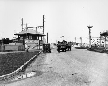
... Nepean Highway... and streetscapes in what is now the City of Kingston. The Nepean Highway ...This image is part of a larger collection of images from the Public Transport Corporation displaying train stations and streetscapes in what is now the City of Kingston.The Nepean Highway is a major highway running through the City of Kingston. This image is one of many that depicts its importance to the local community as it undergoes many changes over time.Black and white photograph depicting the level crossing at Moorabbin. While the gates at the level crossing are open, two cars are making their way across the crossing, while a third car is parked on the side of the road, in front of a large billboard/hoarding for ham and bacon products. There is a man standing on the road as if watching the cars go through the crossing. The road appears to be unsealed. Black printed text on a round white sticker adhered to the reverse: 148 Handwritten in red ink: 60% Blue ink stamped on reverse: COPYRIGHT / Public Transport Corporation / For re-ordering photographs / Please quote negative No ADU907 / Enquiries C/- PTC Photographic Unit / Telephone switchboard 619 111moorabbin, trains, railway crossing, level crossing, cars, roads, nepean highway -
 City of Kingston
Photograph - Black and white, c. 1930
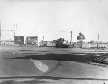
... Nepean Highway... and streetscapes in what is now the City of Kingston. The Nepean Highway ...This image is part of a larger collection of images from the Public Transport Corporation displaying train stations and streetscapes in what is now the City of Kingston.The Nepean Highway is a major highway running through the City of Kingston. This image is one of many that depicts its importance to the local community as it undergoes many changes over time.Black and white photograph of the level crossing at Neapean Highway Moorabbin. Photograph is a slightly side view, with a blurred image of a car approaching the level crossing. The gates are closed. To the left of the image is a pair of billboards. The billboard on the left is promoting Creamoata, a New Zealand brand of oats, and the billboard on the right is promoting Kraft cheese.White round sticker on reverse with black printed text: 147 Handwritten in red ink on reverse: 100% Blue ink stamped on reverse: COPYRIGHT / Public Transport Corporation / For re-ordering photographs / Please quote negative No ADV 1030 / Enquiries C/- PTC Photographic Unit / Telephone switchboard 619 111moorabbin, level crossing, railway crossing, cars, advertising, nepean highway -
Glen Eira Historical Society
Document - Historic Conservation Areas Project
... Nepean Highway... Dandenong Road Nepean Highway Hotham Street Iknerman Road Orrong ...Contains 4 items relating to historic conservation: 1/Five newsletters (one page each newsletter, dated 07/1975, 08/1975, 09/1975, 10/1975 and the final one 12/1975) describing how the project evolved, project funds, progress, study method, project 1 report, project 2 report and summary as no further funds available. Project was to include all of Melbourne but funding did not allow this. Note: newsletters stamped with Caulfield Historical Society. 2/Letter (one page on official city of Caulfield letterhead) from Andrew Rodda (manager planning) to Hazal Ford (dated 13/11/1989) describing ‘council resolved on 18/07/1989 to proceed with preliminary conservation survey’ and mentions that a copy is included. 3/Preliminary conservation survey for the City of Caulfield (nine pages) describing background, study area, budget, purpose, study outline, timeframe, report format, ownership, tasks and background information (mentions number and types of houses and properties as at 1986 and 1988) and a map of City of Caulfield. 4/Booklet (28 pages) titled ‘Heritage Area – Caulfield North Draft Heritage Guidelines July 1999 – City of Glen Eira’, containing Caulfield North Heritage Area, cultural heritage, Heritage Overlay Area, architectural description, common architectural forms and features, development guidelines, key design checklist. It includes a map of the Caulfield North Heritage Overlay Area, two illustrations about the development envelope and many black-and-white photographs of houses and architectural features.historic conservation areas project niven barbara, newsletters, town planning, historic buildings, heritage studies, housing, royal historical society of victoria (rhsv), read michael, plans, local government, historical societies, committee for urban action (cua), national trust, hopkins sherry ms., ford hazel, preliminary conservation survey, town planning, heritage studies, rodda andrew, city of caulfield, housing estates, victoria national estate grants program, australia icomos, burra charter, buildings structures and establishments, land surveys, suburbs, historic buildings, architectural significance, ‘caulfield’s heritage study’, soloman geulah dr., caulfield library, dandenong road, nepean highway, hotham street, iknerman road, orrong road, north road, poath road, ‘plan of the city of caulfield’, north ward, east ward, south ward, west ward, kooyong road, neerim road, bambra road, balaclava road, shire of caulfield, railways, world war 1914-1918, depression 1929-1939, rippon lea, labassa, parks, mansions, community services, ‘caulfield north draft heritage guidelines july 1999’, city of glen eira, caulfield north heritage area, glen eira heritage management plan, mayfield grove, normanby avenue, carnarvon street, glenferrie street, arthur street, malakoff street, normanby road, heritage advisory service, construction materials, victorian style, mediterranean style, spanish mission style, californian bungalow style, federation style, architectural style, architectural features, heritage conservation design, building construction, building regulations, aboriginal peoples, carnarvon road -
 Chelsea & District Historical Society Inc
Photograph - Chelsea Flood December 1934, Wells Road, Chelsea
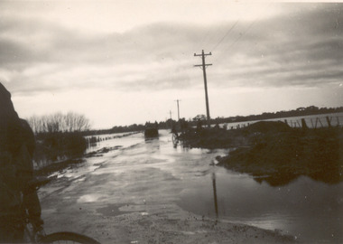
... Nepean Highway.... flood chelsea Dandenong Creek Nepean Highway Point Nepean Road ...In December 1934, 700 houses were inundated with water, when the Dandenong Creek and Patterson River broke their banks.Three Black and white photo of flood waters across Wells Road, Chelsea. A SEC truck can be see travelling down Wells Road in photo one and two, with people viewing the flooded street.flood, chelsea, dandenong creek, nepean highway, point nepean road -
 Chelsea & District Historical Society Inc
Photograph - Chelsea Flood December 1934
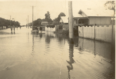
... Nepean Highway.... flood chelsea Dandenong Creek Nepean Highway Point Nepean Road ...In December 1934, 700 houses were inundated with water, when the Dandenong Creek and Patterson River broke their banks.Two Black and white photo of flood waters in Chelsea. flood, chelsea, dandenong creek, nepean highway, point nepean road -
 Chelsea & District Historical Society Inc
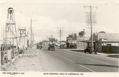
Photograph - Shopping Area, Aspendale, c 1930's
... Nepean Highway...Point Nepean Road Nepean Highway Aspendale Taylor Avenue ...Black and white postcard showing shops on the right hand side of Point Nepean Road and the railway line, Aspendale railway station and the Aspendale Fire Station with the bell tower beside it. One car driving along the road and two cars parked. The shops in view are a cafe, a general store, the Aspendale Picnic Grounds, which included Palais De Dance.The Rose Series P. 1037 MAIN SHOPPING AREA IN ASPENDALE, VIC.point nepean road, nepean highway, aspendale, taylor avenue, shops, aspendale fire station, aspendale picnic grounds -
 Chelsea & District Historical Society Inc
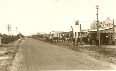
Photograph - Point Nepean Road, Chelsea
... Nepean Highway...Chelsea Point Nepean Road Nepean Highway railway Black ...Black and white photo of Chelsea, showing Point Nepean Road, the railway line, people, shops, horse and cart and bicycles. Chelsea Railway Station can be seen in the distance. Shops that can be identifies are the Chelsea General Store, J & C Caudwell and Timber Merchant.chelsea, point nepean road, nepean highway, railway -
Clunes Museum
Container - BOTTLE
... SIZE, DISPENSED BY W.I. BUSH AND CO. 3 NEPEAN HIGHWAY, MENTONE... AND CO. 3 NEPEAN HIGHWAY, MENTONE, VIC. Container BOTTLE ...BROWN SCREWTOP BOTTLE CONTAINING OIL OF CLOVES - ONE POUND SIZE, DISPENSED BY W.I. BUSH AND CO. 3 NEPEAN HIGHWAY, MENTONE, VIC.local history, medicine, dentistry, medical pharmacy -
 Old School House Museum
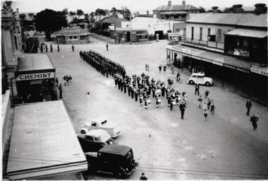
Photograph
... Copy of an older photo, Corner of Bay St (Nepean Highway... St (Nepean Highway) and Playne St Frankston. Marching band ...Copy of an older photo, Corner of Bay St (Nepean Highway) and Playne St Frankston. Marching band followed by Possible service men or scouts -
 Chelsea & District Historical Society Inc
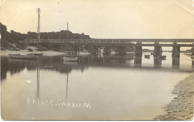
Photograph - Patterson River, Rail and Road Bridge
... / Nepean Highway) and rail bridge, near the mouth of the Patterson... (Point Nepean / Nepean Highway) and rail bridge, near the mouth ...The first bridge over the river was built in the early 1880's, prior to this it was a pontoon bridge.Black and white photo of the road bridge (Point Nepean / Nepean Highway) and rail bridge, near the mouth of the Patterson River. Taken from the mouth of the river.patterson river, road bridge, rail bridge, chelsea, transport, patterson river bridge, carrum bridge -
 City of Moorabbin Historical Society (Operating the Box Cottage Museum)
Photograph - 3 black & white Photographs, 'The Grange' ( 'Baydon Hill' ) Moorabbin, c 1920
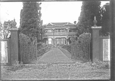
... Tuck, originally named 'Baydon Hill' , at 1011 Nepean Highway... Nepean Highway Moorabbin built by Mr Charles Tuck c1853 known..., originally named 'Baydon Hill' , at 1011 Nepean Highway, Moorabbin ...'The Grange ' was a 2 storey home built 1857 by Mr Charles Tuck, originally named 'Baydon Hill' , at 1011 Nepean Highway, Moorabbin ( South Brighton). Mr Charles Tuck was Veterinary Surgeon from Baydon Hill, Wiltshire, England, who migrated to Australia c1850. He married his cousin Miss Jan Chaudler in Melbourne in1853. He was at the Ballarat gold-fields at the time of the riots and then they settled in South Brighton ( later Moorabbin) and built a large Georgian Styled home called 'Baydon Hill'. The Tucks had a large family - 9 children. Charles enjoyed a prosperous Veterinary Practice as his advice was needed for stock purchases by the farmers / settlers. Charles died in 1893 and Jane left the property c 1903 and died at Blackburn in 1928. The House had 5 owners, the last being the Healey family c1920 and at some stage the name was changed to 'The Grange' and the gates shown were installed. The Healey Family were also prosperous in developing vegetables and flower seeds and seedlings. 'The Grange' was sold to Moorabbin City Council 1972 and then used by the City of Moorabbin Historical Society for meetings and storage of historical material. It was demolished amidst considerable controversy 1983 and the District Police Offices were built on the site. ( S.T.Mulvany, Grand-daughter of Charles Tuck 26/7/1974)The Grange was a significant property 1853 -1983 in Moorabbin. It was built by Mr Charles Tuck 1857and in1900 extended from Point Nepean Road to South Road - 10acres. Mr Harold James Healey purchased the property in c1920 and leased a portion to a Chinese market gardener. Later with his sons he established a profitable Plant Nursery that they managed for 42years.. Keith Healey, a son, remodelled the house extensively mid 20thC .The Moorabbin City Council purchased it in 1972 for $255,000 and it was demolished amid controversy 1983. The District Police Offices are now on the site.3x black and white photographs of the property at 1011 Nepean Highway Moorabbin built by Mr Charles Tuck c1853 known as 'The Grange'. Originally it was named 'Baydon Hill' because he migrated from Baydon Hill, Wiltshire, England c1850. These photographs are c 1880, 1920 and 1950 showing the original and later additions made to the property by some of the 5 owners.Written in pencil on back a) " This Photo donated by Mr Neil Follett - at the time it came into his possession he had a photography studio in Cheltenham. Photographer unknown"; Folio 6 b) The Grange c 1950 Folio 6/10 c) 'Baydon Hill' ( alias "The Grange" ) / Donated by Mrs Elsa Jones, daughter of Leslie Stephen Tuck, youngest son of Charles Tuck Folio 6 /18tuck charles, tuck jane, veterinary surgeons, livestock, market gardeners, early settlers, dendy's special survey, brighton, moorabbin, ballarat, gold diggings, horses, chickens, cattle, bullocks, flower shows, fruit garden, mulvaney s. t., healey haold james, healey keith, moorabbin city council, chinese market gardeners, plant nursery, tuck leslie stephen, jones elsa -
 Chelsea & District Historical Society Inc
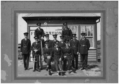
Photograph - Carrum Fire Brigade, Firemen, c 1918-20
... Nepean Highway.... weatherboard building on Point Nepean Highway. Firemen Photograph ...Twelve members of the Carrum Fire Brigade standing in front of the fire station which was situated in Point Nepean Road, Carrum :- Back row - Harry Thompson, Les (Bud) Peters. Middle row - Ernie Bunn, Harold Barnes, Percy Tregent, Neil Mathieson, Alf Owen, Jack Owen, Larry Rentell. Front row - Alf Higgins, Alvie Symons, Fred Barnes (father of Harold).Black and white photo on backing board of 12 members of the Carrum Fire Brigade and some of their equipment standing in front of the Carrum Fire Station, a small weatherboard building on Point Nepean Highway.fire station, carrum fire brigade, firemen, fire equipment, chelsea -
 City of Kingston
Negative - Colour, 1926
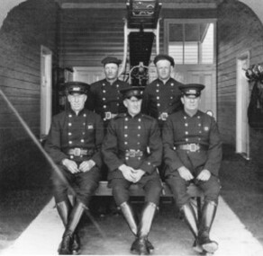
... Cheltenham Fire Station, Nepean Highway. The second image... Station, Nepean Highway. The second image is of the firefighting ...Until 1911 Cheltenham had a local Voluntary Fire Brigade. In that year the Metropolitan Fire Brigade was formed and through it a hall was built on the Highway at a cost of £350. Eight years later a brick house costing £1151 was added. There were two full time firemen; several others served part time. In 1960 the fire protection system was re-organised; the building on the Highway was demolished and replaced by the Ambulance Station.Two images on one strip of negative film. The first image is a black and white image of five firefighters pictured inside Cheltenham Fire Station, Nepean Highway. The second image is of the firefighting truck at the station. -
 City of Kingston
Photograph - Black and white, 20 December 1945
... ), Nepean Highway and Jamieson Street. Highett Gas Works is visible...), the Methodist Children Homes (now Southland), Nepean Highway ...This aerial photograph depicts the changing landscape of Cheltenham and Highett since WWII. Photographed in 1945, there is a mix of urban dwellings and industrial development and precedes the major transformation of Cheltenham with the development of the Southland shopping centre in the 1960s and expansion in the 1990s.A large part of Cheltenham was originally established as a rural market gardening community. The railway line and station brought urban development to the area and in the north, the Highett area was dominated by the Highett Gas Works. Cheltenham became a major destination for shopping in the 1960s with the opening of Southland.Aerial photograph taken in 1945 of Cheltenham and Highett within the City of Kingston. The image includes the Highett Reserve, (top right), the Methodist Children Homes (now Southland), Nepean Highway and Jamieson Street. Highett Gas Works is visible in the top left and the land now named William Fry Reserve at the intersection of Bay Road and Nepean Highway. A visible large parcel of land on the corner of Bay Road and Nepean Highway was developed in the 1990s as the west side addition to Southland. The densely vegetated area in the upper right sector of the image is now dense with housing. Tulip Grove, Heather Grove and Gilford Street are visible bottom left. This image is possibly from the collection of aerial photographs commissioned by the Department of Crown Lands and Survey and taken by Adastra Airways.Black ink: 57252 White lettering: VIC-10 57252 20.12.45 [lens information indecipherable] PROJ. No.5 MELB. METROP AREA Black pencil: 80highett, cheltenham, highett gas works, urbanisation