Showing 1526 items
matching no. 1 creek
-
 Kiewa Valley Historical Society
Photograph – Photocopy of black and white photograph of Bogong Creek Race Line. 17/1/51, 17/01/1951
... Bogong Creek Race Line. 17/1/51 ... of black and white photograph of Bogong Creek Race Line. 17/1/51 ...A start on the construction of Bogong Creek race line was made at the commencement of winter in 1948. Work proceeded in the following years when work on the High Plains was not practicable. In January, 1951 the special trimming machine, the special slip form and concrete mixing and placing equipment was put into service. A shortage of cement caused some delays as well as a sudden financial recession. The race line was completed and put into service in 1952.An historical record showing the machinery used during this time, the number of workers and supervisors involved and the mountainous terrain where they worked. It also demonstrates the OH&S of the period with workers mostly in street clothing with no hard hats or other safety equipment. Several workers can be seen working shirtless or in singlets.Photocopy of a black and white SECV photograph No: K 6209 labelled Bogong Creek Race Line ch. 1700. Depicting large group of workers and supervisors working at the site. Dated 17/1/52Printed underneath the photograph: STATE ELECTRICITY COMMISSION OF VICTORIA Date: 17/1/51 Time: 10.30am No: K 6209 Kiewa Hydro-Electric Works Bogong Creek Race Line ch. 1700 bogong creek raceline; secv; kiewa hydro electric scheme; -
 Kiewa Valley Historical Society
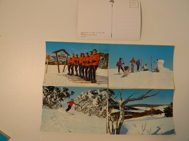
Postcards - Falls Creek - Set of 4
Postcards were available at tourist destinations to promote the resort by enabling visitors to write to friends and family.The Kiewa Hydro Electric Scheme hastened the development of Falls Creek as a popular destination for skiers. Roads, buildings including accommodation & chalets, ski clubs, snow vehicles, ski tows etc enabled visitors to live and ski in the snow. When construction of the KHES was completed Falls Creek continued to develop both as a winter and summer resort. Serrated edge colored postcards. 1. "On Langlauf Skis in the Australian Snowfields' - Photograph by Uwe Steinward 2. 'Ski-school and instructors at Falls Creek, Victoria' Photograph by Uwe Steinward x2 3. Overlooking the Victorian snowfields, Falls Creek, Victoria' Photograph by Uwe Steinward 4. 'Skiing down the slopes at Falls Creek, Victoria.' photograph by Uwe Steinward x3falls creek, snow, skiing, alpine sport, langlauf skmiing, uwe steinward -
 Kiewa Valley Historical Society
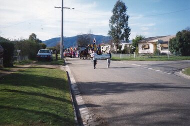
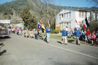
Photographs – Set of 25 colour photographs of the street parade to celebrate the first Official Hoppet race run at Falls Creek in 1991, 1991
In 1977 a group of Mount Beauty cross country skiers formed the Birkebeiner Nordic Ski Club. In 1979, a version of the famous Birkebeiner race, the first Australian Birkebeiner was held at Falls Creek. In June 1990 representatives from Australia put their case for a southern hemisphere race in the series. Following a trial event in 1990. Australia became the 12th member of Worldloppet in the winter of 1991, with the first Kangaroo Hoppet. In 1991 a parade and commemorative torch lighting ceremony were organised in Mt Beauty as part of the celebrations to mark the first official Kangaroo Hoppett with participation from local community groups and commercial organisations, the Chamber of Commerce, local government representatives and individuals.Kangaroo Hoppet caters to diverse interests by offering a 42km and 21km event. It also offers a 7km event that attracts skiers, ranging from elite juniors to parents, grandparents, babies and first time skiers. It is recognised on the world cross country ski race calendar. It brings large numbers of participants and spectators to the area which support tourism, local businesses and employment. The 2018 event will be the 28th Kangaroo Hoppet, with cross country skiers travelling from across the country and overseas to compete.PHYSICAL: Set of 22 colour photographs of the street parade to celebrate the first Official Hoppet race run at Falls Creek in 1991. Participants from a range of local community groups are traveling along Kiewa Cres. Photos are taken near the corner of Maddison St 1&2 – Horseman & accordion player leading the parade Sign reads ‘Falls Creek The Happy Mountain’ 3-4 Birkbeioner Nordic Ski Club with Chinese Nordic ski representatives 5 & 6- Girl Guides & Brownies 7, 8 & 9- Mt Beauty Primary School & Netball team 10 & 11- UKV Calisthenics Club 12- Lawn Bowls Club 13- Junior Football Club 14- Mt Beauty High School Band (on Wodonga Timber & Hardware truck) 15, 16 17 & 18- Mt Beauty Kindergarten 19,20, 21 & 22- Local Community Vehicles including Community Transport and Fire Brigade 23 & 24- Mt Beauty High School Band 25- Fiat 500 Topolino Vintage Car No markingskangaroo hoppet; cross country skiing; ski race; bogong high plains, mt beauty, parade -
 Kiewa Valley Historical Society
Photographs – Set of 13 colour photographs of the street parade to celebrate the first Official Hoppet race run at Falls Creek in 1991, 1991
In 1977 a group of Mount Beauty cross country skiers formed the Birkebeiner Nordic Ski Club. In 1979, a version of the famous Birkebeiner race, the first Australian Birkebeiner was held at Falls Creek. In June 1990 representatives from Australia put their case for a southern hemisphere race in the series. Following a trial event in 1990. Australia became the 12th member of Worldloppet in the winter of 1991, with the first Kangaroo Hoppet. In 1991 a parade and commemorative torch lighting ceremony were organised in Mt Beauty as part of the celebrations to mark the first official Kangaroo Hoppett with participation from local community groups and commercial organisations, the Chamber of Commerce, local government representatives and individuals.Kangaroo Hoppet caters to diverse interests by offering a 42km and 21km event. It also offers a 7km event that attracts skiers, ranging from elite juniors to parents, grandparents, babies and first time skiers. It is recognised on the world cross country ski race calendar. It brings large numbers of participants and spectators to the area which support tourism, local businesses and employment. The 2018 event will be the 28th Kangaroo Hoppet, with cross country skiers travelling from across the country and overseas to compete.Set of 13 colour photographs of the street parade to celebrate the first Official Hoppet race run at Falls Creek in 1991. Participants were from a range of local community groups and local industry representatives. Photos were taken on Holland St. opposite the old hospital building. Following the parade, a market stalls were set up on the green outside the Community Centre on Holland St. as part of the Hoppet celebrations. 1 & 2- Boy Scouts and Cubs 3- UKV Lions Club 4 & 5- Local children representing the history and fauna of the High Plains 6- Ambulance Services 7, 8, 9 & 10 – Representatives and equipment from local forestry industry 11- Vintage truck by Vintage Charms Tours providing tours of the local area for visitors 12 & 13- Market stalls set up on the green outside the Community Centre on Holland St. as part of the Hoppet celebrations. kangaroo hoppet; ski race; cross country skiing; bogong high plains, mt beauty, parade, -
 Kiewa Valley Historical Society
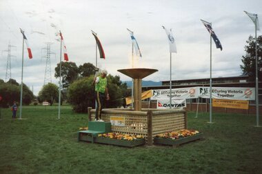
Photographs – Set of 21 colour photographs of the Opening Ceremony and commemorative torch lighting to celebrate the first Official Hoppet race run at Falls Creek in 1991, 1991
... race run at Falls Creek in 1991 1-3 - John Konrads (1956... race run at Falls Creek in 1991 1-3 - John Konrads (1956 ...In 1977 a group of Mount Beauty cross country skiers formed the Birkebeiner Nordic Ski Club. In 1979, a version of the famous Birkebeiner race, the first Australian Birkebeiner was held at Falls Creek. In June 1990 representatives from Australia put their case for a southern hemisphere race in the series. Following a trial event in 1990. Australia became the 12th member of Worldloppet in the winter of 1991, with the first Kangaroo Hoppet. In 1991 a parade and commemorative torch lighting ceremony were organised in Mt Beauty as part of the celebrations to mark the first official Kangaroo Hoppett with participation from local community groups and commercial organisations, the Chamber of Commerce, local government representatives and individuals.Kangaroo Hoppet caters to diverse interests by offering a 42km and 21km event. It also offers a 7km event that attracts skiers, ranging from elite juniors to parents, grandparents, babies and first time skiers. It is recognised on the world cross country ski race calendar. It brings large numbers of participants and spectators to the area which support tourism, local businesses and employment. The 2018 event will be the 28th Kangaroo Hoppet, with cross country skiers travelling from across the country and overseas to compete.Set of 21 colour photographs of the Opening Ceremony and Commemorative Torch lighting to celebrate the first Official Hoppet race run at Falls Creek in 1991 1-3 - John Konrads (1956 Olympic Swimmer) lighting the Commemorative Torch with the original torch used at the 1956 Olympics at the MCG in Melbourne. 4-13 – Official opening ceremony and torch lighting by Liberal representative for Indi Mr Lou Leibermann. MC’d by Mr Ken Bell, representing the Chamber of Commerce 14 – Parachute fly over by Mr Ross Schult 15-18 – Photographs of the Multi National flags displayed in the commemorative garden in front of the SECV administration buildings. Flags represent the countries participating in the Kangaroo Hoppet. Snow-capped Mt Bogong in the background. 19-21 – Commemorative torch, erected by SECV to commemorate the first official Kangaroo Hoppet held at Falls Creek. No markingskangaroo hoppet; cross country skiing; ski race; bogong high plains; opening ceremony, mt beauty, parade -
 Kiewa Valley Historical Society
Photograph - Folder of Photographs (KVHS 1150 A - F) – Photocopied set of black and white photographs from the display folder (pages 1 - 8) put together by KVHS to document life on the Kiewa Valley Hydro-electric Scheme
Although the Kiewa Hydro-Electric Scheme was first proposed in 1911, construction did not commence until 1938. As part of the push to cut electricity costs and diversify supply, the Victorian Government (circa 1930) initiated the conversion from primarily brown coal supply to hydro – electricity. Field investigations during the 1940’s resulted in a new proposal for a scheme that had more than double the capacity of the 1938 scheme. The Kiewa Hydroelectric Scheme became the largest scheme of its kind in the State Of Victoria and the second largest scheme in Australia. The number of personnel involved in the planning and construction of the scheme increased dramatically. During the late 1940’s, most activity centred around the construction of the West Kiewa Power Station, Rocky Valley Reservoir, McKay Creek Power Station and the Bogong Creek Aqueduct.A common thread across all the larger hydro scheme constructions was the need for workers, both qualified and unqualified who came from around the world seeking a new life for themselves and their families. New accommodation and facilities were required for the army of workers engaged in construction in often remote and wild areas. The SEC had a high demand for timber, and set up the first of a number of sawmills at Bogong Creek in 1939 and set up the first hardwood logging in the headwaters of the Kiewa River. These new ‘towns’ such as Mt Beauty and Bogong, survived, serving the needs of operational personnel and their families, and expanding with growth of new industries. Mount Beauty, and to a lesser extent Bogong, are among these places. Large A3 size spiral bound display folder containing 21 of 58 pages of photocopied black and white photographs of various aspects of the early days of the Kiewa Valley Hydro-electric scheme including equipment, various work sites and photographs of workers and their families. 1-Front page; 2-Security gate at Mt Beauty Camp; 3-Channel 1 on East Kiewa River; 4-Junction Dam – Diversion Tunnel Inlet; 5-Sawmill; 6- Homan’s Gap Sawmill; 7 Junction Dam: 8-Homan Dam Site-Diamond Drilling on River Buttress; 9- Homan Dam Site View Upstream 10-Homan Dam Investigation Camp 1-Windsor & Newton Visual Diary 60 sheet (120 pages) 11’ x 14’ 280 x 356mm 110 GSM Acid Free Drawing Paper 2-1940-Security Gate on Mt Beauty side of Kiewa River bridge. Part of old Mt Beauty camp and mess in background 3- STATE ELECTRICITY COMMISSION OF VICTORIA Date; 11.3.40 Time: 10.30am No K35 Kiewa Hydro Electric Works. Diverting East Kiewa River into Channel Page number 1 4-STATE ELECTRICITY COMMISSION OF VICTORIA Date: 5.4.40 Time: Noon No K58 Kiewa Hydro Electric Works. Junction Dam – Diversion Tunnel Inlet – Normal Flow Page number 2 5- STATE ELECTRICITY COMMISSION OF VICTORIA Date: 19.8.42 Time: 2.30pm No K883 Kiewa Hydro Electric Works. Sawmill – General View Page number 3 6- STATE ELECTRICITY COMMISSION OF VICTORIA Date: 12.1.42 Time: 2.00pm No K540 Kiewa Hydro Electric Works. Homan’s Gap Sawmill – General View Page number 4 7- STATE ELECTRICITY COMMISSION OF VICTORIA Date: 12.1.42 Time: 2.00pm No K540 Kiewa Hydro Electric Works. Junction Dam – General View looking upstream Page number 5 8- STATE ELECTRICITY COMMISSION OF VICTORIA Date: 16.11.45 Time: 10.32amm No K52153 Kiewa Hydro Electric Works Homan Dam Site – Diamond Drilling on River Buttress Page number 6 9-STATE ELECTRICITY COMMISSION OF VICTORIA Date: 15.1.45 Time: 4.10pm No K1781 Kiewa Hydro Electric Works Homan Dam Site – View Upstream Page number 7 10- STATE ELECTRICITY COMMISSION OF VICTORIA Date: 15.1.45 Time: 4.10pm No K1781 Kiewa Hydro Electric Works Homan Dam Investigation Camp 1944 – 1945 Page number 8 secv; kiewa hydro electric scheme; mt beauty; bogong; construction work; -
 Kiewa Valley Historical Society
Photograph - Folder of Photographs – Photocopied set of black and white photographs (pages 9 - 18) from the display folder put together by KVHS to document life on the Kiewa Valley Hydro-electric Scheme
Although the Kiewa Hydro-Electric Scheme was first proposed in 1911, construction did not commence until 1938. As part of the push to cut electricity costs and diversify supply, the Victorian Government (circa 1930) initiated the conversion from primarily brown coal supply to hydro – electricity. Field investigations during the 1940’s resulted in a new proposal for a scheme that had more than double the capacity of the 1938 scheme. The Kiewa Hydroelectric Scheme became the largest scheme of its kind in the State Of Victoria and the second largest scheme in Australia. The number of personnel involved in the planning and construction of the scheme increased dramatically. During the late 1940’s, most activity centred around the construction of the West Kiewa Power Station, Rocky Valley Reservoir, McKay Creek Power Station and the Bogong Creek Aqueduct.A common thread across all the larger hydro scheme constructions was the need for workers, both qualified and unqualified who came from around the world seeking a new life for themselves and their families. New accommodation and facilities were required for the army of workers engaged in construction in often remote and wild areas. The SEC had a high demand for timber, and set up the first of a number of sawmills at Bogong Creek in 1939 and set up the first hardwood logging in the headwaters of the Kiewa River. These new ‘towns’ such as Mt Beauty and Bogong, survived, serving the needs of operational personnel and their families, and expanding with growth of new industries. Mount Beauty, and to a lesser extent Bogong, are among these places. PHYSICAL: Large A3 size spiral bound display folder containing 21 pages of photocopied black and white photographs of various aspects of the early days of the Kiewa Valley Hydro-electric scheme including equipment, various work sites and photographs of workers and their families. 1-Bridge across Tailrace Channel 1946 2-New Mess building, Mt Beauty 3-Homan’s Gap Saw Mill 4- Diamond Drilling Plant – Big Hill 5-Rocky Valley Camp-Mess Building 6-Parlimentary Party at Rocky Valley 7-No.4 Headrace Tunnel 8- Allis-Chalmers Tractor School 9- SECV Heavy Machinery lined up by road 10- No. 5 Raceline – Balasting Track with improvised truck 1-1946 – Bridge across tailrace channel Page number 9 2-New mess building, Mt Beauty 6.4.46 Page number 10 3- STATE ELECTRICITY COMMISSION OF VICTORIA Date: 10.1.47 Time: 11.40am No K2271 Kiewa Hydro Electric Works Homan’s Gap Saw Mill – Rip Saw Page number 11 4- STATE ELECTRICITY COMMISSION OF VICTORIA Date: 5.10.47 Time: 11am No K4111 Kiewa Hydro Electric Works Diamond Drilling Plant – Big Hill Page number 12 5- STATE ELECTRICITY COMMISSION OF VICTORIA Date: 11.2.48 Time: 3pm No K4277 Kiewa Hydro Electric Works Rocky Valley Camp-Mess Building Page number 13 6- STATE ELECTRICITY COMMISSION OF VICTORIA Date: 15.4.48 Time: 4.30pm No K4397 Kiewa Hydro Electric Works Parlimentary Party at Rocky Valley Page number 14 7- STATE ELECTRICITY COMMISSION OF VICTORIA Date: 22.8.48 Time: 9am No K4668 Kiewa Hydro Electric Works General view of No.4 Headrace Tunnel Page number 15 8-STATE ELECTRICITY COMMISSION OF VICTORIA Date: 5.9.49 Time: 10am No K5180 Kiewa Hydro Electric Works Allis-Chalmers Tractor School – HD 19, Mr I Crossthwaite at Controls Page number 16 9- No markings Page number 17 10- STATE ELECTRICITY COMMISSION OF VICTORIA Date: 7,12.49 Time: 4pm No K5423 Kiewa Hydro Electric Works No. 5 Raceline – Balasting Track with improvised truck. Page number 18 secv; kiewa hydro electric scheme; mt beauty; bogong; construction area -
 Kiewa Valley Historical Society
Photograph - Folder of Photographs – Photocopied set of 10 black and white photographs (pages 19 - 28) from the display folder put together by KVHS to document life on the Kiewa Valley Hydro-electric Scheme
Although the Kiewa Hydro-Electric Scheme was first proposed in 1911, construction did not commence until 1938. As part of the push to cut electricity costs and diversify supply, the Victorian Government (circa 1930) initiated the conversion from primarily brown coal supply to hydro – electricity. Field investigations during the 1940’s resulted in a new proposal for a scheme that had more than double the capacity of the 1938 scheme. The Kiewa Hydroelectric Scheme became the largest scheme of its kind in the State Of Victoria and the second largest scheme in Australia. The number of personnel involved in the planning and construction of the scheme increased dramatically. During the late 1940’s, most activity centred around the construction of the West Kiewa Power Station, Rocky Valley Reservoir, McKay Creek Power Station and the Bogong Creek Aqueduct.A common thread across all the larger hydro scheme constructions was the need for workers, both qualified and unqualified who came from around the world seeking a new life for themselves and their families. New accommodation and facilities were required for the army of workers engaged in construction in often remote and wild areas. The SEC had a high demand for timber, and set up the first of a number of sawmills at Bogong Creek in 1939 and set up the first hardwood logging in the headwaters of the Kiewa River. These new ‘towns’ such as Mt Beauty and Bogong, survived, serving the needs of operational personnel and their families, and expanding with growth of new industries. Mount Beauty, and to a lesser extent Bogong, are among these places. Large A3 size spiral bound display folder containing 21 pages of photocopied black and white photographs of various aspects of the early days of the Kiewa Valley Hydro-electric scheme including equipment, various work sites and photographs of workers and their families. 1-Allis Chalmers Tractor School 2- Gardens outside Administrative Office – Mt Beauty 3- Mt Beauty house – 1950 4-Bridge over Pretty Valley River, Bogong 5-Rocky Valley Spillway Tunnel break through 6-Ni 1 Headrace Tunnel drilling face 7-No 4 Power Station Drilling 8-Clover Dam Flood Waters 9-No1 Head Race Tunnel Portal Building 10-Clover Dam 1-STATE ELECTRICITY COMMISSION OF VICTORIA Date: 5.9.49 Time: 10amm No K5174 Kiewa Hydro Electric Works Allis Chalmers Tractor School Page number 19 2-STATE ELECTRICITY COMMISSION OF VICTORIA Date: 22.2.50 Time: 3.30pm No K5601 Kiewa Hydro Electric Works Gardens outside Administrative Office – Mt Beauty Page number 20 3-Mt Beauty house – 1950 Page number 21 4-STATE ELECTRICITY COMMISSION OF VICTORIA Date: 23.10.50 Time: 11.15am No K6331 Kiewa Hydro Electric Works Bogong-Bridge over Pretty Valley River Page number 22 5-STATE ELECTRICITY COMMISSION OF VICTORIA Date: 23.6.50 Time: 2.30pm No K5844 Kiewa Hydro Electric Works ROCKY VALLEY SPILLWAY TUNNEL BREAK THROUGH Page number 23 6-20/3/52 – No. 1 Headrace Tunnel Drilling face (E.E.E. contract) Page number 24 7-6/6/52 – No 4 Power Station – Drilling Page number 25 8-STATE ELECTRICITY COMMISSION OF VICTORIA Date: 6/6/52 Time: No K7113 Kiewa Hydro Electric Works Clover Dam Flood Waters Page number 26 9-STATE ELECTRICITY COMMISSION OF VICTORIA Date: Oct 1952 Time: No K7239 Kiewa Hydro Electric Works No. 1 HEAD RACE TUNNEL PORTAL BUILDING. Handwritten underneath – This information from Ron White-the later Principal Hydro Engineer of the SEC. Oct 1952 Location incorrect? All work on No 1 had ceased after financial crash of 1951. This photo would refer to No 4 Headrace Tunnel? Page number 27 10-STATE ELECTRICITY COMMISSION OF VICTORIA Date: Jan 1953 Time: No K7307 Kiewa Hydro Electric Works CLOVER DAM Page number 28 secv; kiewa hydro electric scheme; bogong; mt beauty; construction area -
 Kiewa Valley Historical Society
Photograph - Folder of Photographs – Photocopied set of 10 black and white photographs (pages 29 - 38) from the display folder put together by KVHS to document life on the Kiewa Valley Hydro-electric Scheme
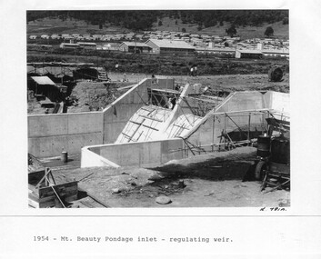
Although the Kiewa Hydro-Electric Scheme was first proposed in 1911, construction did not commence until 1938. As part of the push to cut electricity costs and diversify supply, the Victorian Government (circa 1930) initiated the conversion from primarily brown coal supply to hydro – electricity. Field investigations during the 1940’s resulted in a new proposal for a scheme that had more than double the capacity of the 1938 scheme. The Kiewa Hydroelectric Scheme became the largest scheme of its kind in the State Of Victoria and the second largest scheme in Australia. The number of personnel involved in the planning and construction of the scheme increased dramatically. During the late 1940’s, most activity centred around the construction of the West Kiewa Power Station, Rocky Valley Reservoir, McKay Creek Power Station and the Bogong Creek Aqueduct.A common thread across all the larger hydro scheme constructions was the need for workers, both qualified and unqualified who came from around the world seeking a new life for themselves and their families. New accommodation and facilities were required for the army of workers engaged in construction in often remote and wild areas. The SEC had a high demand for timber, and set up the first of a number of sawmills at Bogong Creek in 1939 and set up the first hardwood logging in the headwaters of the Kiewa River. These new ‘towns’ such as Mt Beauty and Bogong, survived, serving the needs of operational personnel and their families, and expanding with growth of new industries. Mount Beauty, and to a lesser extent Bogong, are among these places. Large A3 size spiral bound display folder containing 21 pages of photocopied black and white photographs of various aspects of the early days of the Kiewa Valley Hydro-electric scheme including equipment, various work sites and photographs of workers and their families. 1-Mt Beauty Pondage inlet-Regulating weir 2-Langfords Gap Basalt Hill-Tunnel in quarry face.3-Rocky Valley Camp-from Engineering Office 4-Basalt Hill tunnel portal 5-No 1 Pressure Shaft Works Bench 6-No 1 Power Station 7-Overturned haulage wagons on the side of an embankment 8- Group of workers dressed in wet weather gear inside a tunnel 9-Workmen and vehicle in tunnel 10-Howman’s Gap campsite at 4,150 feet 1-1954 – Mt Beauty Pondage inlet – Regulating weir Page number 29 2-28/10/54 – Langfords Gap Basalt Hill – Tunnel in quarry face K7860 Page number 30 3-STATE ELECTRICITY COMMISSION OF VICTORIA Date: 17.8.55 Time: No K8132 Kiewa Hydro Electric Works ROCKY VALLEY CAMP – FROM ENGINEERING OFFICE Page number 31 4-28/10/54 – Basalt Hill tunnel portal K7859 Page number 32 5-No.1 Pressure Shaft Works Bench 5.7.56 Page number 33 6- No. 1 Power Station 26.4.59 Page number 34 7- No markings Page number 35 8-No markings (Wooden board on ground printed with - POLAR A.N.GELATINE DYNAMITE “75” DE 28.8.40) Page number 36 9-No markings Page number 37 10-Howman’s Gap campsite at 4,150 feet Page number 38 secv; kiewa hydro electric scheme; mt beauty; bogong; construction area -
 Kiewa Valley Historical Society
Photograph - Folder of Photographs – Photocopied set of black and white photographs (pages 49 -58) from the display folder put together by KVHS to document life on the Kiewa Valley Hydro-electric Scheme
Although the Kiewa Hydro-Electric Scheme was first proposed in 1911, construction did not commence until 1938. As part of the push to cut electricity costs and diversify supply, the Victorian Government (circa 1930) initiated the conversion from primarily brown coal supply to hydro – electricity. Field investigations during the 1940’s resulted in a new proposal for a scheme that had more than double the capacity of the 1938 scheme. The Kiewa Hydroelectric Scheme became the largest scheme of its kind in the State Of Victoria and the second largest scheme in Australia. The number of personnel involved in the planning and construction of the scheme increased dramatically. During the late 1940’s, most activity centred around the construction of the West Kiewa Power Station, Rocky Valley Reservoir, McKay Creek Power Station and the Bogong Creek Aqueduct.A common thread across all the larger hydro scheme constructions was the need for workers, both qualified and unqualified who came from around the world seeking a new life for themselves and their families. New accommodation and facilities were required for the army of workers engaged in construction in often remote and wild areas. The SEC had a high demand for timber, and set up the first of a number of sawmills at Bogong Creek in 1939 and set up the first hardwood logging in the headwaters of the Kiewa River. These new ‘towns’ such as Mt Beauty and Bogong, survived, serving the needs of operational personnel and their families, and expanding with growth of new industries. Mount Beauty, and to a lesser extent Bogong, are among these places. Large A3 size spiral bound display folder containing photocopied black and white photographs of various aspects of the early days of the Kiewa Valley Hydro-electric scheme including equipment, various work sites and photographs of workers and their families. 1-Workmen working inside one of the tunnels. 2-Workman drilling in West Kiewa Tunnel 3-Junction Dam wall construction 4&5-2B&W photographs Kiewa House residents ready to go to a ball in Mt Beauty 6-Workmen warming up in front of a fire at No 1 bench 7-Workmen being hauled in at No 4 P.S Shaft 8-No 4 Power Station – Drilling 9-Workmen eating a hot meal in the tunnel. 10-2 photographs (a)Pretty Valley camp showing workman’s huts and construction materials & (b)Worker in Langford Gap Basalt Hill Tunnel face 11-Tunnel entrance (unlabelled) with rail tracks in foreground 12- Workmen drilling at No 1 Head race tunnel-Drilling face 13- No 1 Power Station 14-Workmen at the entrance to one of the SECV tunnels under construction 1-SECV number at bottom of picture Half obscured possibly K8461 Page number 53 2-In West Kiewa Tunnel Page number 54 3- Construction of Junction Dam wall – approximately 1941 Page number 55 4&5- Residents of Kiewa House at Bogong ready to go to the ball at Mt Beauty-1946. Handwritten on a copy of the photo on opposite page Mrs Lorna Crosset filled out the names *Dad was Des Crossett – his daughter is Gael Petcopoulis Greta engaged to John broke it off. Charlie, Rosalind, Bill, Priscilla, Max Lawrence-Dad’s Boss, Mary & Max married, Mary, Kay, Gwen McPherson Mum’s boss, John McCluskey (c) At No. 5 Bench Page number 56 6- STATE ELECTRICITY COMMISSION OF VICTORIA Date: 27.2.51 Time:2.15pm No K6373 Kiewa Hydro Electric Works No. 4 P.S. Shaft – Haulage of men in buckets (b) As above Handwritten at top of photo Appendix 4 page number 57 7- STATE ELECTRICITY COMMISSION OF VICTORIA Date: 6.6.52 Time:… No K7122 Kiewa Hydro Electric Works No. 4 POWER STATION – DRILLING page number 58 8-No markings page number 59 9-(a)Handwritten under photograph Approx. 1948/49 (b) STATE ELECTRICITY COMMISSION OF VICTORIA Date: 28.10.54 Time:.. No K7860 Kiewa Hydro Electric Works LANGFORD GAP BASALT HILL TUNNEL FACE Page number 49 10-(a) No markings 11- STATE ELECTRICITY COMMISSION OF VICTORIA Date: 20.3.52 Time: No K6979 Kiewa Hydro Electric Works No. 1 HEAD RACE TUNNEL – DRILLING FACE (E.E.E. CONTRACT) ‘The Frenchies’ (E.E.E) as they were affectionately known Page number 50 12-31.5.56 No. 1 Power Station Aggregate Stock Piles. Page number 51 13&14-No markings Page number 52 secv; kiewa hydro electric scheme; bogong; mt beauty; construction area -
 Kiewa Valley Historical Society
Photograph - Folder of Photographs – Photocopied set of black and white photographs (pages 39 - 48) from the display folder put together by KVHS to document life on the Kiewa Valley Hydro-electric Scheme
Although the Kiewa Hydro-Electric Scheme was first proposed in 1911, construction did not commence until 1938. As part of the push to cut electricity costs and diversify supply, the Victorian Government (circa 1930) initiated the conversion from primarily brown coal supply to hydro – electricity. Field investigations during the 1940’s resulted in a new proposal for a scheme that had more than double the capacity of the 1938 scheme. The Kiewa Hydroelectric Scheme became the largest scheme of its kind in the State Of Victoria and the second largest scheme in Australia. The number of personnel involved in the planning and construction of the scheme increased dramatically. During the late 1940’s, most activity centered around the construction of the West Kiewa Power Station, Rocky Valley Reservoir, McKay Creek Power Station and the Bogong Creek Aqueduct.A common thread across all the larger hydro scheme constructions was the need for workers, both qualified and unqualified who came from around the world seeking a new life for themselves and their families. New accommodation and facilities were required for the army of workers engaged in construction in often remote and wild areas. The SEC had a high demand for timber, and set up the first of a number of sawmills at Bogong Creek in 1939 and set up the first hardwood logging in the headwaters of the Kiewa River. These new ‘towns’ such as Mt Beauty and Bogong, survived, serving the needs of operational personnel and their families, and expanding with growth of new industries. Mount Beauty, and to a lesser extent Bogong, are among these places. Large A3 size spiral bound display folder containing photocopied black and white photographs of various aspects of the early days of the Kiewa Valley Hydro-electric scheme including equipment, various work sites and photographs of workers and their families. 1-Breakdown in Circuit Breaker (Isolating Contacts) 2-Big Hill Bench- Site of No 5 Devlopment 3-No 1 Power Station 4-No 1 Pipeline, Anchor No 8 5-Push Dozing-RD8 Tractor 6- Tractor and driver at work 7- Workmen in unnamed tunnel 8- Front page of Journal of SECV Vol 15. Photograph of No 1 pipeline viewed from McKay Portal 9-Rocky Valley Dam Core Wall 10-Workmen working inside tunnel loading rocks into a rail truck. 1-Breakdown in (generator) Circuit Breaker (Isolating Contacts) Handwritten underneath (This is not a picture of any part of a generator. It is a circuit breaker Signed Ron White Ron was the Principal Hydro Engineer of the SEC Kiewa Scheme Page number 39 2-Big Hill Bench – Site of No. 5 Development (abandoned) Page number 40 3-No 1 Power Station Page number 41 4-No. 1 Pipeline, Anchor No. 8 Page number 42 5-Push Dozing – RD8 Tractor, 12 cubic yard Carryall and FD Cletrac Tractor Page number 43 6-No marking Page number 44 7-No marking Page number 45 8-Journal of State Electricity Commission of Victoria SEC Vol 15 No… April-May, 19… No 1 Pipeline-A view from McKay Portal G Hempenstall and D Sutton stiffening pipe section for transport during construction (….indicates missing text) Page Number 46 9-Rocky Valley Dam Core Wall Page number 47 10-No markings Page number 48 secv; kiewa hydro electric scheme; construction area; power stations; reservoirs; aqueduct; mt beauty; bogong -
 Kiewa Valley Historical Society
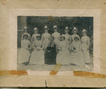
Photographs – Group of 3 old sepia photographs, 2 of women in period costume and 1 of group of nurses from Sunbury sanatorium
Europeans arrived in the Kiewa Valley in the 1830s and 40s. Following the drought of 1838-44 seeking out the rich pastures in the fertile Kiewa Valley. . The next major increase in population was as a result of the Kiewa Hydro Scheme. The beginning of construction of the Kiewa Hydro-electric scheme in the late 1940s introduced changes and led to the enlargement and improvement of local roads and the townships of Mount Beauty and Bogong Village were constructed by the SECV from the 1930’s to the 1950’s to house workers on the Kiewa Hydro Electric Scheme. At its peak the Kiewa Scheme employed around 4000 people from all walks of life and as many cultures.The influx of European migrants to work on the Hydro Scheme along with their rich cultural backgrounds, all played a major part in establishing the history of the area and in shaping the future character of the Mount Beauty, the Kiewa Valley and Falls Creek areas. Photographs may depict descendants, family or friends of early settlers or workers in the Kiewa Valley region.1. Sepia photograph, mounted on heavy buff card with yellowing marks from sticking tape across the bottom of the photograph. Photograph is of a group of nurses taken at the Sunbury Sanitorium 2. Sepia photograph mounted on heavy buff card with yellowing marks from sticking tape at top and bottom of photo. Mark from drawing pin in centre top of photo. Photograph is of a middle aged woman posing dressed in period costume 3. Sepia photograph mounted on heavy buff card with yellowing marks from sticking tape at top and bottom of photo. Mark from drawing pin in centre top of photo. Photograph is of an older woman posing dressed in period costume sepia photos; nurses; kiewa valley; sunbury sanitorium; period costume -
 Kiewa Valley Historical Society
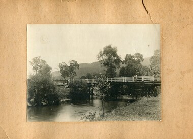
Photographs- 1 old black and white photograph of a wooden bridge over a river possibly Ryders Bridge in Tawonga. 2 –Enlargement of the original photograph showing the gentleman leaning on the bridge. Taken off the original photo
... the Kiewa River on Mountain Creek Rd Tawonga The first Tawonga ...The bridge is not definitively identified, but is of similar construction style to other bridges built in rural areas around this time. Circa 1930”s and may be Ryders Bridge (Old Tawonga Bridge) which crosses the Kiewa River on Mountain Creek Rd Tawonga The first Tawonga bridge was built in 1884- destroyed by floods in 1916. New bridge constructed 1923 and destroyed in 1953. Present concrete bridge constructed in 1986 and named Ryders Bridge These wooden bridges were the only method for transporting stock and produce to market, transporting timber to the mills, sending and receiving mail and for local people to cross the many rivers in the area to go about their daily business. 1- Black and white photograph is glued onto heavy cardboard, which is yellowing with age. Top right hand corner has a tear in the cardboard. Photograph depicts a wooden bridge on wooden piles with 2 white wooden railings along the length of both sides. 2- Original photo has been digitally enlarged to show a gentleman in a light coloured suite and wearing riding boots leaning on the rails of the bridge. The bridge is not definitively identified, but is of similar construction style to other bridges built in rural areas around this time. Circa 1930”s may be Ryders Bridge (Old Tawonga Bridge) which crosses the Kiewa River on Mountain Creek Rd Tawonga bridge; tawonga bridge; kiewa valley -
 Kiewa Valley Historical Society
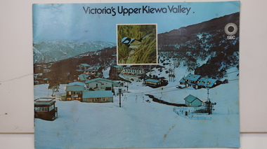
Booklet - SEC x2, 1. Victoria's Kiewa Valley 2. Victoria's Upper Kiewa Valley, No. 2 is dated October 1978
The State Electricity Commission of Victoria built the Kiewa Hydro Electric Scheme and was keen to promote tourism in the area. The booklet includes Facilities, Falls Creek Ski Resort, the Kiewa Works Area, the Three Floras of Bogong, the Geology of the Kiewa area, the Bird and Animal life of Bogong and the Kiewa Hydro Electric Scheme. The colored photos and the map on the back appeal to the reader/tourist.The SECV promoted tourism in the Kiewa Valley especially the area of the Kiewa Hydro Electric Scheme. This booklet is attractive and informative with a lot of detail. This proved to be the early stages of tourism in the area in what is now a very popular tourist destination and the main industry for the Upper Kiewa Valley.Blue cover with photo of Falls Creek at night. Title in black print at the centre top under which is an insert photo of a blue wren and SEC logo in white towards the top far right. Back cover is light green with a tourist map of the area. The text is complimented with brightly colored photos throughout.state electricity commission of victoria; kiewa hydro electric scheme; tourism; bogong; flora; fauna; geology; -
 Kiewa Valley Historical Society
Maps, Unknown
There are 2 maps: 1. Broadbent's Makers of Maps since 1896, No. 323 Across the Alps/Official Copyright Map./ The cover is blue, green and orange with advertising for Ólympic' and 'Bosch' and there is further advertising on the fold out covers/ 2/-. 2. Robinson's Kiewa Hydro-Electric Scheme & Hotham Heights Map No. 613, with Insets of: Bright, Mt Beauty, Falls Creek Ski Village, Hotham Heights Ski Village/ the cover is blue, green and orange with image of skier, hydro tower and locality map./Other fold out sides have advertising and information for tourists./ 4/-.maps, tourism, kiewa hydro electric scheme, victorian alps, skiing -
 Kiewa Valley Historical Society
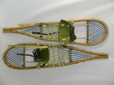
Snow Shoes
Snow shoes were used to move between places on the snow fields at Falls Creek and the Bogong High Plains especially during the construction of the Kiewa Hydro Scheme.Historical: Snow shoes were used on the Bogong High Plains during winter. The body is made of light wood 'bamboo' with a back and front wooden cross bar. Between the front cross bar and toe, blue nylon is tied to form diamonds 'lacing', similarly the back. Between the bars, in the middle is cream coloured rope tied to form a strong basket. A shoe harness made of olive green vinyl to which is clipped brown strong woven material tape with a circular steel loop through which the tape is threaded. There are 3 steel fasteners on 1 side and 2 on the other with a black plastic fastener. At the front between the cream and blue woven baskets there is a gap called the toe hole. The rope is attached either side of the toe hole to the front wooden bar.snow. falls creek. bogong high plains. transport. victorian alps. -
 Kiewa Valley Historical Society
Benzol Pouring Can - Tobacco
Historical: Tobacco farming began circa 1960 in the Kiewa Valley and consequently became one of its major industries. Many of the Italian families were involved in tobacco farming. Historical: This equipment was used on one of the first tobacco farms in the Kiewa Valley at Glenns Creek, Mongans Bridge. The can was home-made showing the resourcefulness of farmers living in the Kiewa Valley. Provenance: This tobacco farmer came from Italy and was sponsored to visit a tobacco farmer in Mytleford to learn how to grow tobacco so that he could transfer those skills to his own farm in the Kiewa Valley. Used for pouring Benzol into special long flat troughs in seed beds. Rusty tin rectangular can with handle on 1 side, opposite side has a spout coming from the bottom of the can reaching out higher than the can and held in place by a flat piece of tin jutting out from the can. At the top there is a screw opening with a lid and a handle both on one half of the top and on the other half an opening has been cut.tobacco, kiewa valley, mongans bridge, glenn creek, handmade can. benzol. aurora. silvano rossaro. -
 Kiewa Valley Historical Society
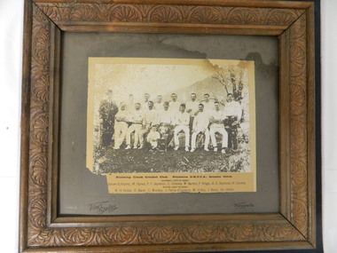
Photo - Running Creek Cricket Club
Running Creek belonged to the Upper Kiewa Valley Cricket Association and were premiers in 1913 - 1914. They dressed in whites with long sleeved shirts and trousers. The umpire was dressed very formally. The names of the players are local families and included brothers or relations with the same surname.Historical: Running Creek were premiers of the Upper Kiewa Valley Cricket Association in 1913 - 1914. Their team consisted of local men some of whom were related. The occasion was important enough to have a photo and to remember it possibly hanging the photo up in a public place eg. club rooms.Black & white photo of Running Creek Cricket Team, Premiers 1913 - 1914. Upper Kiewa Valley Cricket Association Far left - The umpire fully dressed in suit & hat and far right man with white shirt & black trousers. In between 13 cricketers in 2 rows and a child beside the cup at the front. Names of players are typed below the photo. Photo is glued on grey cardboard, framed in brown decorative wooden frame. Back: String attached 1 side only.Title, names of players. Grey cardboard - Vine's Studios / Wangaratta. On back handwritten "Donated by Mrs J. Woodside / Guluguba / Queensland / on 19 July 1972cricket. running creek. upper kiewa valley cricket association. sport. vine's studio. -
 Kiewa Valley Historical Society
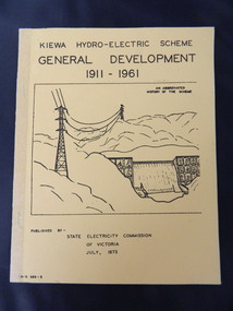
Book - Kiewa Hydro Electric Scheme 1911-1961, Kiewa Hydro-Electric Scheme /General Development / 1911-1961, July, 1973
The book is an abbreviated history of the Kiewa Hydro Electric Scheme.This book summarises the stages of the Kiewa Hydro Electric Scheme from its conception in 1911 through to 1961. The newspaper cutting gives additional information about Rocky Valley Dam.Yellow cardboard book with front cover of black writing and sketch of power lines and spillway in the mountains. 2 staples are covered along the spine with tape. There are 22 pages. 2 copies Inside one copy there is a newspaper cutting entitled "Main Dam in Kiewa Scheme Finished" and later published pages of 1. Floras of Bogong 2. Geology of Kiewa Area 3. Fauna and 4. 'Brief history of the Kiewa Scheme. An abbreviated History of the SchemeOn the newspaper cutting hand written "Burnett 1959 Later than May."kiewa hydro electric scheme. mt beauty. dederang. bogong. mckay creek power station. west kiewa power station. clover power station. secv. rocky valley dam. flora. fauna. geology. -
 Kiewa Valley Historical Society
Folder - Early Photos of Mt Beauty
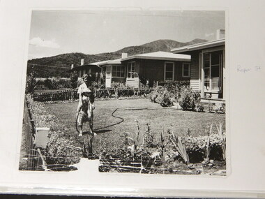
Mt Beauty township was built during the 1950's to house the employees of the State Electricity Commission working on the Kiewa Hydro Electric Scheme. After the completion of the Kiewa Hydro Electric Scheme many houses were sold and the public buildings handed over to the Alpine Shire. Mt Beauty has always been a tourist destination especially with its proximity to the ski fields at Falls Creek.This folder contains many early photos of Mt Beauty showing the construction town during its development during the Kiewa Hydro Electric Scheme and its early days of tourism. A3 size black plastic folder with clear plastic sleeves holding early black & white photos of Mt Beauty township. Also included are: 1. 3 foolscap pages -Nov., 1953 Kiewa Hydro-Electric Scheme Progress. 2. SECV Drawing Plan (No. K6242) of Mt Beauty House - 3 angles and floor plan, English Pre-cut Type 3B.ILA with note that all houses with prefix 3B are similar. 3. Orange, black and white pamphlet "Welcome to Kiewa" 4. Tourist postcard 'fold-up' of 11 postcards "Mt Beauty and the Kiewa Scheme, Victoria 5. Drawing Plan of 'Mt Beauty Housing. Use of Prefabricated Cubicles for Houses. Type C.1 6. Drawing Plan of 'Kiewa Scheme Mt Beauty Housing Type "G". 7. 5 pages on "Twelve Tips on Caring for Old Buildings 8. Booklet advertising Mt Beauty housing for sale including activities available in the area. (1960's) 9. List of Photos from SECV held by KVHS Some photos have handwritten labels mt beauty. secv. kiewa hydro electric scheme.tourism. housing. construction town. falls creek. -
 Kiewa Valley Historical Society
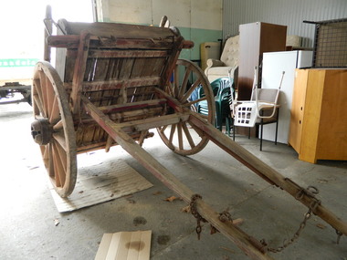
Tipping Dray
The dray was pulled by a horse and used to transport road building materials such as gravel. The tray carried 0.7 of a cubic metre which would have weighed about 1 tonne (varying on the load being wet or dry).This tipping dray was owned by John Briggs who carried gravel on the Tawonga to German Creek Road from 1894 to 1895. Workers were paid 2/- (shillings) per day to cover sections that were called 'a paddock' resulting in workers finishing at 10 or 11 pm. The road opened on the 17th March 1896 at a cost of 1700 pounds. See KVHS 0960 for newspaper article re Tom Briggs and making (and photo) of the Tawonga Gap road.Old single axil wooden dray with wooden spoke wheels and a tipping wooden tray.tipping dray. john briggs. tawonga. german creek. road building. transport. -
 Kiewa Valley Historical Society
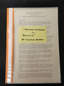
Folder - Clare Roper No. 1, Items of Interest
Clare Roper was a resident of the Kiewa Valley and belonged to the Kiewa Valley Historical Society.Clare Roper collected and collated items of historical interest for the Kiewa Valley Historical Society. Orange plastic with clear front cover and 10 clear sleeves / pages. Includes - SECV brochure "Visit Victoria's beautiful Upper Kiewa Valley" Newspaper Article 30 July 1986 - "Ory Frehauf 'Father' - 61 year old Russian has lived at Falls Creek for 32 years" and an article - "Snow shoeing at Falls Creek" Newspaper Article 4 Nov. 1989 - Audrey Edmondson at Mt Beauty Pondage & Lions Clubclare roper; scrap book; -
 Warrnambool and District Historical Society Inc.
Map - Fire Maps, Region 5 Fire Control Map, 1963
Two fire maps of south west Victoria.1 This is a rectangular piece of linen folded several times to form a packet with the front part covered with a brown card. The cover has a blue and white label. The map has a white base with red and green markings and red and black printing .2 As .1 abovenon-fictionTwo fire maps of south west Victoriafire maps, warrnambool history -
 Eltham District Historical Society Inc
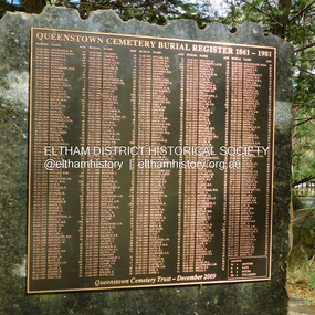
Photograph, Jim Connor, Queenstown Cemetery Burial Register 1861-1981, Queenstown Cemetery, Smiths Gully Road, St Andrews, 8 March 2023
Installed by the Queenstown Cemetery Trust December 2009 The discovery of gold in Smyth's Creek in 1854 and subsequent gold rush to the Caledonia diggings led to the establishment of Queenstown (present day St Andrews). The first recorded burial was July 31st, 1861 and it was officially declared a Cemetery Reserve in 1866. Many graves are unmarked and unrecorded including many Chinese and other itinerant miners. The cemetery was closed for new burials in 1851. The last recorded burial was in 1981 in an existing family grave.jim connor collection, 2023-03-08, queenstown cemetery, smiths gully road, st andrews -
 Eltham District Historical Society Inc
Document - Folder, Mann, John and Violet and family
John Mann arrived from Forfar, Scotland, on the clipper packet "Ellen Stuart" in 1857 and rented a farm "Overton" at Janefield. Soon after he met Melbourne-born Violet McKimmie, whose parents had a property near Darebin Creek. They married on 25 September 1862, John 26 and Violet 19. In 1874 John selected a block on Arthurs Creek and built a slab and bark hut (still standing in 1984) and called their farm "Carseburn" after John's parish in Scotland. They had seven children: John, Jane, Christine, David, Walter, James and Violet. John was drowned in the Yarra in May 1875 and Violet struggled to meet the lease commitment. She wrote to her brother-in-law David Mann in New Zealand who came to her aid, and on 10 September 1876, they married at the Victorian Free church, Smith Street, Collingwood. They improved the farm and built a three-room house. in July 1883 they bought neighbouring land from Ann Welsh. With David, Violet had four more children: Robert, William and twins Thomas and Henry. In 1883, David died and was buried in the same grave as his brother in Preston Cemetery. The twins also died, Thomas just before and Henry just after their father. the children assisted with the farm and orchard, the business including crops, a dairy herd, Carseburne sheep, and breeding horses. Violet died at Yan Yean in 1925, aged 83. A grandson of John Mann, James Mann, lived in Henry Street, Greensborough and had given a talk at the Whittlesea Historical Society in 1983 on his family. Descendant Lindsay Mann was part of a creative writing group that published a book including a short story "The Mountain Tramway" is loosely based on his childhood and stories he was told then but was planning to write his family story. Contents Newspaper article: "Tragedy couldn't stop this pioneer", Diamond Valley News, 31 January 1984, story of Mann family. Newspaper article: "Tracing the history of ordinary. people," Diamond Valley News, 29 July 1986, story of Mann family, researched by descendant Lindsay Mann who grew up at the Mann property She-Oak at Yan Yean and has numerous family records. Newspaper article: "A realist who captures light," Diamond Valley News, 29 July 1986, David Moore, a realist painter had been working from a studio at Montsalvat and his exhibition of work from that period was to open 1 August 1986 at the Victorian Artists Society Galleries.Newspaper clippings, A4 photocopies, etcjohn manan, violet mann nee mckimmie, clipper packet "ellen stuart", forfar scotland, darebin creek victoria, arthurs creek victoria, "overton" at janefield, "carseburn" at arthurs creek, jane mann, christine mann, david mann, walter mann, james mann, violet mann, victorian free church smith street collingwood, ann welsh, robert mann, william mann, thomas mann, henry mann, preston cemetery, carseburne sheep, yan yean cemetery, lindsay mann, david moore, montsalvat -
 Eltham District Historical Society Inc
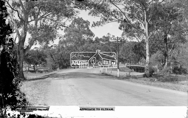
Negative - Photograph postcard, The Rose Stereograph Company, Approach To Eltham, c.1939
Looking east along the unsealed main road heading into Eltham across the concrete bridge over the Diamond Creek circa 1939. The original wooden bridge was destroyed by flood waters in 1924. This glass plate negative was used to manufacture postcards (1:1 printing) for commercial sale by the Rose Sterograph Company and its subsidiaries. George Rose founded the Rose Stereograph Company in 1880 and was joined by Herbert (Bert) Cutts in the early 20th Century. The pair formed a lifetime working partnership and strong personal friendship. Assisted by George’s two sons, Herbert George and Walter, and later by Neil Cutts, the Rose Stereograph Company continued its operations for more than 140 years. The company was initially built on stereographs, but as cinema took over and stereographs fell out of fashion, the Rose Stereograph Company developed Australia’s first commercially viable photographic postcard business. Specialising in postcards of iconic historical moments and significant landmarks, The Rose Stereograph Company became a staple of the Australian travel industry.This remarkable collection of glass plate negatives, transparencies, and postcards – arguably Australia’s most significant photography collection outside of public hands – has been passed down through the generations, surviving war, relocation, and the harsh Victorian climate. The historic Rose Stereograph collection is the culmination of George Rose’s dream of capturing and preserving precious moments in time and remains the legacy of the Rose and Cutts families. It is with great sadness that the Cutts family says goodbye to a collection that spans five generations and 140 years. The Cutts family understands that for these historically important pieces to rest with one family is to deny others the pleasure of their custodianship.Glass Plate Negative Size: 9 x 14 cmApproach to Eltham, Valentine Series No. 3197, Copyrightbuildings, electricity lines, eltham, postcard, travel, rose stereograph company, valentine series postcard, main road bridge, glass plate negative, main road, peter and elizabeth pidgeon collection, diamond creek (creek), eltham south, rose stereograph -
 Eltham District Historical Society Inc
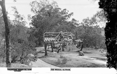
Negative - Photograph, The Rose Stereograph Company, The Bridge, Eltham, c.1939
Looking west across the Main Road Bridge over the Diamond Creek at Eltham, c.1939. The car in the foreground, possibly the photographer's, is a Ford Model C Ten built by Ford UK between 1934 and 1937. The Model C was released in Australia in 1935. The Ford Model C Ten is a car that was built by Ford UK between 1934 and 1937. The Model C was released in Australia in 1935 https://en.wikipedia.org/wiki/Ford_Model_C_Ten This glass plate negative was used to manufacture postcards (1:1 printing) for commercial sale by the Rose Sterograph Company and its subsidiaries. George Rose founded the Rose Stereograph Company in 1880 and was joined by Herbert (Bert) Cutts in the early 20th Century. The pair formed a lifetime working partnership and strong personal friendship. Assisted by George’s two sons, Herbert George and Walter, and later by Neil Cutts, the Rose Stereograph Company continued its operations for more than 140 years. The company was initially built on stereographs, but as cinema took over and stereographs fell out of fashion, the Rose Stereograph Company developed Australia’s first commercially viable photographic postcard business. Specialising in postcards of iconic historical moments and significant landmarks, The Rose Stereograph Company became a staple of the Australian travel industry.This remarkable collection of glass plate negatives, transparencies, and postcards – arguably Australia’s most significant photography collection outside of public hands – has been passed down through the generations, surviving war, relocation, and the harsh Victorian climate. The historic Rose Stereograph collection is the culmination of George Rose’s dream of capturing and preserving precious moments in time and remains the legacy of the Rose and Cutts families. It is with great sadness that the Cutts family says goodbye to a collection that spans five generations and 140 years. The Cutts family understands that for these historically important pieces to rest with one family is to deny others the pleasure of their custodianship.Glass Plate Negative Size: 9 x 13.9 cmThe Bridge, Eltham, Valentine Series No. 3196, Copyrightpeter and elizabeth pidgeon collection, bridge, cars, diamond creek (creek), eltham, eltham south, ford model c ten, glass plate negative, main road, main road bridge, motor vehicles, postcard, rose stereograph, rose stereograph company, valentine series postcard -
 Eltham District Historical Society Inc
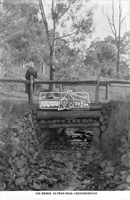
Photograph, The Rose Stereograph Company, Log Bridge, Eltham Road. Greensborough, c.1920
A woman stands at the end of a log bridge over a creek looking towards the south along the unsealed roadway. The sun illuminates her back. She is wearing a woollen knit beanie with edges rolled up, dark jacket and skirt, full length dark stockings and slip on dark leather shoes with raised heel, typical of the early 1920s. The creek is possibly feeding into the Karingal Yalloc. The direction of the road based on shadows is northwest as is the Eltham Road to Greensborough (present day Sherbourne, Karingal and St Helena roads). The creek is falling to the foreground so from south west to the north east, possibly feeding into the Karingal Yalloc, somewhere near presenet day Ramptons Road Reserve. This glass plate negative was used to manufacture postcards (1:1 printing) for commercial sale by the Rose Sterograph Company and its subsidiaries. George Rose founded the Rose Stereograph Company in 1880 and was joined by Herbert (Bert) Cutts in the early 20th Century. The pair formed a lifetime working partnership and strong personal friendship. Assisted by George’s two sons, Herbert George and Walter, and later by Neil Cutts, the Rose Stereograph Company continued its operations for more than 140 years. The company was initially built on stereographs, but as cinema took over and stereographs fell out of fashion, the Rose Stereograph Company developed Australia’s first commercially viable photographic postcard business. Specialising in postcards of iconic historical moments and significant landmarks, The Rose Stereograph Company became a staple of the Australian travel industry.This remarkable collection of glass plate negatives, transparencies, and postcards – arguably Australia’s most significant photography collection outside of public hands – has been passed down through the generations, surviving war, relocation, and the harsh Victorian climate. The historic Rose Stereograph collection is the culmination of George Rose’s dream of capturing and preserving precious moments in time and remains the legacy of the Rose and Cutts families. It is with great sadness that the Cutts family says goodbye to a collection that spans five generations and 140 years. The Cutts family understands that for these historically important pieces to rest with one family is to deny others the pleasure of their custodianship.Glass Plate Negative Size: 9.2 x 13.8 cmLog Bridge, Eltham Road, Greensborougheltham, postcard, travel, rose stereograph company, glass plate negative, creek, eltham road, greensborough, karingal road, karingal yallock, log bridge, sherbourne road, st helena road, women's fashion, rampton's road reserve, peter and elizabeth pidgeon collection -
 Eltham District Historical Society Inc
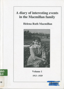
Book - Diary, Helena Ruth Macmillan (nee Heatley), A diary of interesting events in the Macmillan family, Volume 1, 1913-1929, 2012
Ex Yarra Plenty Regional Library; barcodes and Dewey labelshelena ruth macmillan (nee heatley), arthur's creek, diary, recollections -
 Eltham District Historical Society Inc
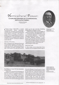
Document - Folder, Bruce G Draper, Draper, 2011
Folder on Draper family contents: 1. Magazine article: Horticultural Pioneer: Charles Draper of Charnwood, Arthur's Creek by Bruce Draper, Australian Garden History, Vol. 15 No. 5, May/June 2004, pp15-20draper family, charnwood, arthur's creek, charles draper, bruce draper