Showing 102 items
matching north-east vic
-
 St Kilda Historical Society
Photograph - Photo map, 14/12/1963
One of a series of photo-maps produced for the Department of Crown Lands and Survey (1857-1983). For correlation with a current map, and access to other historical photo maps of Victoria, see the Historic Photo-Maps Index published by the Department of Environment, Land, Water and Planning at https://services.land.vic.gov.au/DELWPmaps/historical-photomaps/Black and white aerial photographVic 1807 Melbourne 1963 Project Run 16 14.12.63 Lens 205 152.70 M/M 5.150 181st kilda cemetery, caulfield north, st kilda east, armadale, malvern, 1963 -
 St Kilda Historical Society
Photograph - Photo map, 08/02/1966
One of a series of photo-maps produced for the Department of Crown Lands and Survey (1857-1983). For correlation with a current map, and access to other historical photo maps of Victoria, see the Historic Photo-Maps Index published by the Department of Environment, Land, Water and Planning at https://services.land.vic.gov.au/DELWPmaps/historical-photomaps/Black and white aerial photographVic 1916 Melbourne 1966 Project Run 13 E 8.2.66 Lens 122 151.75MM 9.800 111st kilda, balaclava, caulfield, caulfield north, st kilda east, elsternwick, elsterwick park, elwood park, elwood canal, elwood beach, ripponlea, 1966 -
 St Kilda Historical Society
Photograph - Photo map, 11/01/1968
One of a series of photo-maps produced for the Department of Crown Lands and Survey (1857-1983). For correlation with a current map, and access to other historical photo maps of Victoria, see the Historic Photo-Maps Index published by the Department of Environment, Land, Water and Planning at https://services.land.vic.gov.au/DELWPmaps/historical-photomaps/Black and white aerial photographVic 2132 State Aerial Survey Melbourne 1968 Proj Run 27E 11.1.68 5100 ASL 67st kilda east, st kilda cemetery, caulfield north, alma park, balaclava, armadale, 1968 -
 St Kilda Historical Society
Photograph - Photo map, Department of Crown Lands and Survey (1857-1983), 22/01/1970
One of a series of photo-maps produced for the Department of Crown Lands and Survey (1857-1983). For correlation with a current map, and access to other historical photo maps of Victoria, see the Historic Photo-Maps Index published by the Department of Environment, Land, Water and Planning at https://services.land.vic.gov.au/DELWPmaps/historical-photomaps/Black and white aerial photographVic 2358 Department of Crown Lands and Survey Victoria,.© Melbourne 1970 Project Run 41E 22.1.70 5,100 ASL 62caulfield, caulfield north, st kilda east, armadale, 1970 -
 St Kilda Historical Society
Photograph - Photo map, 14/12/1963
One of a series of photo-maps produced for the Department of Crown Lands and Survey (1857-1983). For correlation with a current map, and access to other historical photo maps of Victoria, see the Historic Photo-Maps Index published by the Department of Environment, Land, Water and Planning at https://services.land.vic.gov.au/DELWPmaps/historical-photomaps/Black and white aerial photographVic 1807 Melbourne 1963 Project Run 17 14.12.63 Lens 205 152.70 M/M 5.150 36st kilda, st kilda botanical gardens, balaclava, st kilda east, elwood canal, ripponlea, caulfield north, elwood, caulfield, 1963 -
 St Kilda Historical Society
Photograph - Photo map, Department of Crown Lands and Survey, 22/01/1970
One of a series of photo-maps produced for the Department of Crown Lands and Survey (1857-1983). For correlation with a current map, and access to other historical photo maps of Victoria, see the Historic Photo-Maps Index published by the Department of Environment, Land, Water and Planning at https://services.land.vic.gov.au/DELWPmaps/historical-photomaps/Black and white aerial photographVic 2358 Department of Crown Lands and Survey Victoria,.© Melbourne 1970 Project Run 41E 22.1.70 5,100 ASL 64st kilda, st kilda cemetery, balaclava, st kilda east, windsor, caulfield north, alma park, 1970 -
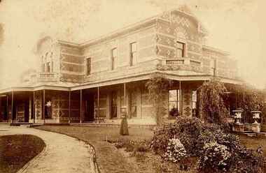 Ruyton Girls' School
Photograph, [Miss Beatrice Henty in the Garden of Tarring], 1904
Beatrice Charlotte Henty was born 25 December 1867, married Graham Frederick Blandy in 1927 and died on 5 March 1950 in Toorak. She did not have any children. Miss Beatrice Henty was the daughter of Henry and Marion Henty. Mr Henry Henty and his wife Mrs Marion Anne Henty (nee McKellar) had ‘Tarring’, Kew built for their family in 1872, and resided there until the death of Marion Henty in 1919. ‘Tarring’ was then sold to Ruyton Girls’ School, and the School moved to the site, (now 12 Selbourne Rd, Kew) in 1920. ‘Tarring’ was renamed ‘Henty House’ by Ruyton Girls' School in honour of its original owners. Ruyton Girls' School was founded in 1878, Miss Beatrice Henty attended the School before 1888. The photograph is dated c.1904. Sepia toned photograph Miss Beatrice Henty in the garden of her family home Tarring, Selbourne Road, Kew. The north east and south facades of the two story brick house are visible in the photo. Beatrice Henty is standing in the garden wearing a long gown and a large hat. A gravel path curves across the lower left corner of the photograph. The photograph is mounted on card.ruyton girls' school, kew, beatrice henty, henry henty, marion henty, tarring, henty house, selbourne road, beatrice blandy, kew (vic), 1900s, 1904 -
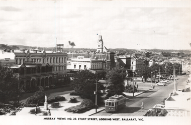 Ballarat Tramway Museum
Postcard, Murray Views, "Murray Views No. 29 Sturt Street, looking west Ballarat Vic", 1948
Photo shows the view looking east along Sturt Street from Harry's building, The card has been wrongly titled as looking west. Tram 32 is westbound to the Gardens. In the view are Lester House, Crockers, and Tunbridge's stores. On the rear Wal Jack in a note to Ken Magor of Newcastle has drawn in a diagram of the track arrangements, where the tram was. His notes are "Sturt St looking EAST, 1948. No. 32 painted the new colour scheme. Photo taken from Doveton St corner." See item 5313 for a digital image of this postcard.Yields information about the view from the SW Corner of Sturt St looking north east.Postcard black and white, plain back, with a handwritten note on rear.See image 2 for details of the handwritten note by Wal Jack on the rear. tramways, trams, sturt st, tram 32 -
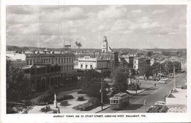 Ballarat Tramway Museum
Postcard, Murray Views, Murray Views No. 29 - Sturt Street Looking West, Ballarat Vic.", c1955
Postcard - black and white - titled Murray Views No. 29 - Sturt Street Looking West, Ballarat Vic.", actually looking east from Doveton St towards Black Hill and Grenville St. Has tram 32 westbound to Gardens via Drummond St North. Divided back postcard with details of the maker on the right hand side, MV symbol and a space for a stamp. In the view are Lester House, Tunbridges, Crockers and the Post Office Tower. A Plume sign is also visible.Yields information about the appearance of Sturt St in the early 1950's, tram operations, buildings and motor vehicles.Postcard - divided back, unused Murray Viewstrams, tramways, sturt st, doveton st, tram 30 -
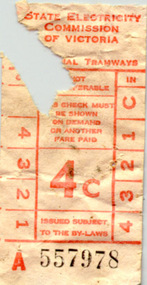 Ballarat Tramway Museum
Ephemera - Ticket/s, State Electricity Commission of Victoria (SECV), Two SEC 4c tickets, late 1960's
Two SEC 4c tickets, light red printing on off white paper, Nos. A557978 and A557979 with portion of tickets missing. See image for one of these tickets. On rear of tickets is a printed diagonal pattern. Handwritten note to Warren Doubleday from Dave Macartney on a piece of ARHS Vic. Div. news sheet explains the origin of these tickets - found blocking the north east sander on tram 18 on 25 April 2000. Possibly these tickets have been in the sand box for over 30 years.trams, tramways, tickets, accidents, maintenance -
 Ballarat Tramway Museum
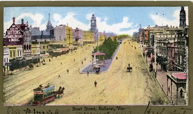
Postcard, Sturt St. from top of the Nicholl and Allan Building, c1904
2437 - Printed colour postcard of the east end of Sturt St. from top of the Nicholl and Allan Building in Grenville St looking west. Has a horse tram leaving the Grenville St. terminus travelling up to Lydiard St. on the north side of Sturt St. Has the buildings on either side of Sturt St. in the view, including Suttons Music store. Titled "Sturt St Ballarat Vic" along the bottom edge. 2437.1 - On the bottom of the postcard is a two line hand written message. On rear of postcard is the address to a Miss C. Haurley of 4 Mortuary Road, South Shields England and two Victorian stamps - half penny (green) and one penny (red) stamps. Has been postmarked "North Melbourne Vic. Feb? 23 05" and over stamped "289" over the penny stamp. See images .1 and .2 2437.2 - On the bottom of the postcard is a single line hand written message. On the rear of postcard is the address to a Mr Frank Tucker, Glencairn, Park Avenue, Harrogate, England. Has two Victorian stamps, half penny (green) and one penny (red) stamps. Has been postmarked twice with the same stamp, "Ballarat East 16.01.04" or 16.11.04?? See images .3 and .4 See Reg Item 5103 for a black and photograph close up of the horse tram in the photo. trams, tramways, horse trams, sturt st, postcards, grenville st -
 Ballarat Tramway Museum
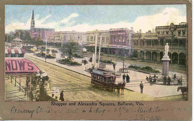
Postcard, "Shoppee and Alexandra Squares Ballarat Vic.", c1904
Printed colour postcard from top of the Town Hall, looking northwest with Snows building in the foreground looking west. Has a horse tram travelling up to Lydiard St. on the south side of Sturt St. Has the buildings on north side of Sturt St. in the view, including the central median reserve before the trees had grown. Titled "Shoppee and Alexandra Squares, Ballarat Vic." along the bottom edge. On the bottom of the postcard is a one line hand written message, ink fading, very hard to read. On rear of postcard is the address to a Mr Frank Tucker, Glencairn, Park Avenue, Harrogate, England. Has two Victorian stamps, half penny (green) and one penny (red) stamps. Has been postmarked, "Ballarat East 16.11.04". See images .1 and .2. Two copies held - on the second copy, the address details have been crossed out and the stamp removed. Yields information about central Ballarat in the horse tram days.Postcard - printed colour, divided back, used.trams, tramways, horse trams, sturt st, postcards, snows, tram 3 -
 Ballarat Tramway Museum
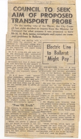
Newspaper, The Courier Ballarat, "Council to Seek aim of Proposed Transport Probe", 6/04/1949 12:00:00 AM
Yields information about the City of Ballarat's concerns of the purpose of a 1949 Transport report proposed by Vic Govt.Newspaper clipping from the Courier, 6-4-1949, titled "Council to Seek aim of Proposed Transport Probe", about the Ballarat Council determining to write to the Minister of Transport seeking the purposes for the proposed report to be done by Mr H. H. Bell Junior on transport problems in Ballarat. Quotes very Councillors who took part in the debate. Alongside the item is a report on the possibly electrification the Ballarat, Bendigo, North East lines and Geelong. Quotes Minister of Transport Mr Kent Hughes. On rear is advertisement for Army Disposals. Contained originally within Reg Item 5623 at the front of this note book. For items see btm5623 loose items list.pdf.ballarat, transport minister, reports, electrification -
 Ballarat Tramway Museum
Photograph - Digital image, Murray Views, Murray Views No. 29 - Sturt Street Looking West, Ballarat Vic.", 1948
Digital image from the Wal Jack Ballarat Album of Photo of Sturt St. looking North East from Town Hall with tram 32 westbound. Tunbridge store (now demolished in photo), Murray Views Photo No. 29. See image i2 for rear of photograph, and 8971 for the actual postcard. See also Reg Item 189 for a larger wider version of this card.Yields information about the appearance of Sturt St looking towards the Post Office c1948.Digital image of a postcard from an album compiled by Wal Jack, loaned to the Museum.On rear of postcard in ink "No. 32 1948"trams, tramways, sturt st, tram 32 -
 Ballarat Tramway Museum
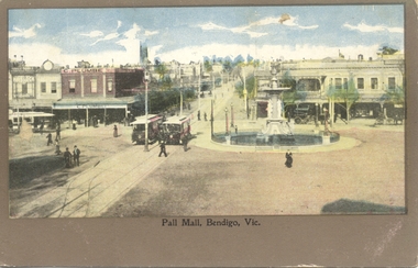
Postcard, Pall Mall Bendigo, early 1900's
Postcard, coloured, Pall Mall Bendigo, looking east towards the Railway Station. Has three trams in the view, along with the fountain. Has C. Plumbe store on the north east corner of the intersection. Title "Pall Mall, Bendigo Vic." Note the small space for a message under the image. On rear, undivided back, with "Post card", "Address to be written on this side" and position for stamp. In the top left hand corner, has "Ian Barkla's" hand stamp. Ian Barkla stamptrams, tramways, bendigo, pall mall -
![Book, A Journey Through Melbourne's East / [by] Fletchers Pty Ltd, 2008](/media/collectors/550653872162f11fb04854aa/items/5d03458521ea7b0950500c7e/item-media/5ebbc47c21ea670348e8dbc7/item-fit-380x285.jpg) Kew Historical Society Inc
Kew Historical Society IncBook, A Journey Through Melbourne's East / [by] Fletchers Pty Ltd, 2008
127 p. : ill. (some col.), ports. ; 26 x 26 cm. fletcher & parker (firm) - history., real estate agents - victoria - balwyn north - history, melbourne (vic.) - history - pictorial works -
 Kew Historical Society Inc
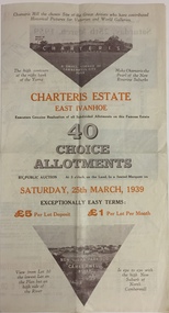
Plan - Subdivision Plan, Charteris Estate, East Ivanhoe, 1939
The Charteris Estate in Ivanhoe was sold in a number of sections. Copies of a subdivision plan of the first section is in the State Library of Victoria collection. This later section of the Charteris Estate includes lots in the Government Boulevard, Castella Street, McArthur Road, Burke Road North, Charteris Drive and Warncliff Road.Subdivision plans like that for the Charteris Estate are invaluable records for local historians identifying when lots in streets were promoted for sale.Four-fold brochure advertising the Charteris Estate in East Ivanhoe in 1939. Streets named on the plan include: the Government Boulevard, Castella Street, McArthur Road, Burke Road North, Charteris Drive and Warncliff Road. The brochure contains photos of Charterisville, the home of F De Castella Esq and also of attractive rolling hills. Annotations in pencilcharteris estate - east ivanhoe (vic), subdivision plans - east ivanhoe (vic) -
 Kew Historical Society Inc
Archive (Sub-series) - Subject File, Kew Historical Society, North East Link, 2019
Various partiesReference, Research, InformationSecondary Values (KHS Imposed Order)Subject file containing documents relating to the development and impact of of North East link in Melbourne.north-east link, transport infrastucure - kew (vic), roads - kew (vic), streets - kew (vic), freeways - kew (vic)north-east link, transport infrastucure - kew (vic), roads - kew (vic), streets - kew (vic), freeways - kew (vic) -
Kew Historical Society Inc
Journal, Kewriosity : March 1992
Kew Festival Special Edition [16pp] / p1. Looking for deregulation in North America / Janet Dore p2&3. Mayor's Comment / Cr Daryl Oldaker p3. New Parking signs / p4. Disabled parking permits / p5. Long term parking p5. Girl Guides & Brownie Guides of Kew / p5. Anyone for tennis? [East Kew Uniting Church] / p5. Football in Kew / p5. New Principal at Hew High School [Alan Taylor] / p6. Trinity Grammar Open Day / p6. Youth Leadership Course / p7. Caritas Christi Hospice Awareness Week / p7. Kew Youth Arts Festival [programme of events] / pp8-9. Diary Dates for March [1992] / p10. Kew Festival Concert at Holy Trinity / p10. Direct Line 2 [Kew Cottages] / p11. Kew Recreation Centre 383-407 High Street, Kew / p11. Healthy fun activities / p11. Free bike identification / p12. Feet feature / p12. New courses at Kew Community House / p13. Kew Junction Commercial Centre / p14. Fundraisers extraordinaire [St. George’s Hospital Kew Ladies’ Auxiliary] / p14. Vale - John Hogan Gervasoni J.P. 1929-1992 / p15. Draft Gaming Machine Policy / p15. Revealing Villa Alba - Open Days / p16.Kewriosity was a local newsletter combining Kew Council and community news. It was published between November 1983 and June 1994, replacing an earlier Kewriosity [broad] Sheet (1979-84). In producing Kewriosity, Council aimed to provide a range of interesting and informative articles covering its deliberations and decision making, together with items of general interest and importance to the Kew community and information not generally available through daily media outlets.non-fictionKew Festival Special Edition [16pp] / p1. Looking for deregulation in North America / Janet Dore p2&3. Mayor's Comment / Cr Daryl Oldaker p3. New Parking signs / p4. Disabled parking permits / p5. Long term parking p5. Girl Guides & Brownie Guides of Kew / p5. Anyone for tennis? [East Kew Uniting Church] / p5. Football in Kew / p5. New Principal at Hew High School [Alan Taylor] / p6. Trinity Grammar Open Day / p6. Youth Leadership Course / p7. Caritas Christi Hospice Awareness Week / p7. Kew Youth Arts Festival [programme of events] / pp8-9. Diary Dates for March [1992] / p10. Kew Festival Concert at Holy Trinity / p10. Direct Line 2 [Kew Cottages] / p11. Kew Recreation Centre 383-407 High Street, Kew / p11. Healthy fun activities / p11. Free bike identification / p12. Feet feature / p12. New courses at Kew Community House / p13. Kew Junction Commercial Centre / p14. Fundraisers extraordinaire [St. George’s Hospital Kew Ladies’ Auxiliary] / p14. Vale - John Hogan Gervasoni J.P. 1929-1992 / p15. Draft Gaming Machine Policy / p15. Revealing Villa Alba - Open Days / p16.publications -- city of kew (vic.), kewriosity, council newsletters, community newsletters -
 Kew Historical Society Inc
Photograph - Yarra in Flood from Willsmere, North Kew, 1923
Flooding of the Yarra Valley, including that section of the Yarra bordering Kew and Kew East in the north and west of the municipality, was a regular occurrence. Extreme flood events of the Yarra River are recorded to have occurred in 1891, 1901, 1916, 1923 and 1934. The Municipality of Kew's response to these floods was to enact planning decisions restricting residential development in flood prone areas following the floods of 1916, 1921 and 1934. While floods continued after the development of the Upper Yarra Reservoir (construction 1948-57), the regularity and extent of these inundations diminished. Original, large sepia photograph showing men, women and children who have gathered on a grassy verge, probably farm land, to look out across the flooded Yarra Valley at Willsmere, North Kew. In the medium distance are three houses that are largely submerged by the flood waters as well as a number of Eucalypts. Judging by the clothes of the spectators, the date might be 1901 or 1916, but probably the latter due to the hats worn by a number of the women. Inscribed reverse: "Gift of Kerrie Woollard (KCC) (P)C.1923yarra river valley, kew east (vic.), floods, willsmere -
Kew Historical Society Inc
Journal, The Kewriosity Sheet Vol.4 No.8 : April 1983
Easter at Kew Library / p1. Easter Services / p1. Hyde Park Fellowship (Hyde Park Uniting Church) / p1. Easing the loneliness of language (Migrant Education; Adult literacy) / p1. The Park Reserve of Boroondara [James Bonwick; Studley Park) / Barbara Giles p2. Save the Children Fund / p2. Kew Garden Club / p2. North Kew Playgroup / p2. Kew Citizens' Advice Bureau / p2. East Kew Uniting Church (calendar of events) / p3. Kew Self Help Group / p3. Treasure and Trash sale / p3. Family and Community Services programme (F.A.C.S.) / p3. Exercise: the rhythmic way (Rosemary Smart) / p3. Native Plant Group / p3. Day Centre for elderly people / p3. Building confidence through movement (Rosemary Smart) / p3. Drivers or non-drivers - do you live in this part of Kew? (Meals on Wheels; Volunteering) / p4. Community Aid Abroad / p4. Kew Philharmonic Society / p4. Call for new members - Merlan Voluntary Services / p4. Scrabble / p4. Easter Service (East Kew Inter Church Council) / p4. Anyone for hockey? / p4.The Kewriosity Sheet (1979-83) was first published in the City of Kew (Victoria) in June 1979 as a two-sided 'community newssheet'. It aimed to: 'share news about Kew happenings and Kew people, and to exchange ideas about living in Kew'. Later issues gradually evolved into a 4-page, quarto sized publication. The Kewriosity Sheet was superseded by the Kew Council publication 'Kewriosity' (1983-1994).non-fictionEaster at Kew Library / p1. Easter Services / p1. Hyde Park Fellowship (Hyde Park Uniting Church) / p1. Easing the loneliness of language (Migrant Education; Adult literacy) / p1. The Park Reserve of Boroondara [James Bonwick; Studley Park) / Barbara Giles p2. Save the Children Fund / p2. Kew Garden Club / p2. North Kew Playgroup / p2. Kew Citizens' Advice Bureau / p2. East Kew Uniting Church (calendar of events) / p3. Kew Self Help Group / p3. Treasure and Trash sale / p3. Family and Community Services programme (F.A.C.S.) / p3. Exercise: the rhythmic way (Rosemary Smart) / p3. Native Plant Group / p3. Day Centre for elderly people / p3. Building confidence through movement (Rosemary Smart) / p3. Drivers or non-drivers - do you live in this part of Kew? (Meals on Wheels; Volunteering) / p4. Community Aid Abroad / p4. Kew Philharmonic Society / p4. Call for new members - Merlan Voluntary Services / p4. Scrabble / p4. Easter Service (East Kew Inter Church Council) / p4. Anyone for hockey? / p4. community publications --- kew (vic.), the kewriosity sheet, newsletters - kew (vic.) -
Kew Historical Society Inc
Journal, The Kewriosity Sheet Vol.4 No.12 : August 1983
R.A.A.V. Action Program 1983 (Rheumatism and Arthritis Association of Victoria) / p1. Kew Library / p1. Council Immunisations (Rubella) / p1. Save the Children Fund / p1. Scrabble / p1. Can you spare some time for your neighbours? (Volunteering; Meals on Wheels) / p1. Meet the editor of "Gardening News" / p1. Correction (Recycling) / p2. Community Centre??? (Kew Swimming Pool; Kew Depot; North Ward Action Group) / p2. Kew Rotaract / p2. Uniting Church East Kew (calendar of events) / p2. S.C.F. fundraising morning (Save the Children Fund) / p2. Kew Recreation Program: Term III - 1983 [short courses] / p2. Kew in that other Depression (Great Depression; 1930s) / Barbara Giles p3. Kew Philharmonic Society / p3. Kew Historical Society / p3. Unique cards: feature views of Kew (Gregary Chase designer) / p3. Look out for funding! (Family and Community Services Program; F.A.C.S.) / p4. "An Asian experience" (The Asian Evangelical Fellowship) / p4. Parkinson's Disease Association / p4. Hyde Park Fellowship (Hyde Park Uniting Church) / p4. Kew drop-In Centre - holiday program (Sacred Heart Church) / p4. Back by popular demand (Kew Garden Club) / p4. Native planet Group / p4. Daytime Garden Club / p4. Camberwell Film Society / p4. Women's Discussion Group / p4.The Kewriosity Sheet (1979-83) was first published in the City of Kew (Victoria) in June 1979 as a two-sided 'community newssheet'. It aimed to: 'share news about Kew happenings and Kew people, and to exchange ideas about living in Kew'. Later issues gradually evolved into a 4-page, quarto sized publication. The Kewriosity Sheet was superseded by the Kew Council publication 'Kewriosity' (1983-1994).non-fiction R.A.A.V. Action Program 1983 (Rheumatism and Arthritis Association of Victoria) / p1. Kew Library / p1. Council Immunisations (Rubella) / p1. Save the Children Fund / p1. Scrabble / p1. Can you spare some time for your neighbours? (Volunteering; Meals on Wheels) / p1. Meet the editor of "Gardening News" / p1. Correction (Recycling) / p2. Community Centre??? (Kew Swimming Pool; Kew Depot; North Ward Action Group) / p2. Kew Rotaract / p2. Uniting Church East Kew (calendar of events) / p2. S.C.F. fundraising morning (Save the Children Fund) / p2. Kew Recreation Program: Term III - 1983 [short courses] / p2. Kew in that other Depression (Great Depression; 1930s) / Barbara Giles p3. Kew Philharmonic Society / p3. Kew Historical Society / p3. Unique cards: feature views of Kew (Gregary Chase designer) / p3. Look out for funding! (Family and Community Services Program; F.A.C.S.) / p4. "An Asian experience" (The Asian Evangelical Fellowship) / p4. Parkinson's Disease Association / p4. Hyde Park Fellowship (Hyde Park Uniting Church) / p4. Kew drop-In Centre - holiday program (Sacred Heart Church) / p4. Back by popular demand (Kew Garden Club) / p4. Native planet Group / p4. Daytime Garden Club / p4. Camberwell Film Society / p4. Women's Discussion Group / p4. community publications --- kew (vic.), the kewriosity sheet, newsletters - kew (vic.) -
Kew Historical Society Inc
Plan - Charteris Estate, Ivanhoe [East], 1927
Subdivision plans and real estate flyers/brochures reveal a number of aspects of urban development and history. The Kew Historical Society's collection of these plans, as well as advertisements extracted from magazines, cover key aspects of community development and architectural history of Kew and Kew Eat as well as surrounding suburbs. While most of the plans in the collection were gifted to the Society by the former City of Kew, a number of other plans and advertisements have been donated by individuals, of which this is an example.Original 4-page bifold handout advertising 43 residential lots for sale in the Charteris Estate subdivision in Ivanhoe [now classified as Ivanhoe East]. This brochure was created to sell the third section of the estate which it labels as 'The Most Superb Section'. Streets within the subdivision include: Burke Road North, McArthur Road, Castella Street, and the Government Boulevard. In addition to the overall plan spread across pages 2 and 3, each page includes a number of interesting photographs including: a number of the new Burke Road Bridge, a sports ground, Hoyts Picture Theatre in Ivanhoe, a croquet ground, and Ivanhoe shopping centre [named Motor Cross Junction].charteris estate - east ivanhoe (vic), subdivision plans -- ivanhoe east (vic.), d.c. mcarthur, charterisville -
 Kew Historical Society Inc
Photograph - River Yarra in Flood from Kilby Road
Flooding of the Yarra Valley, including that section of the Yarra bordering Kew and Kew East in the north and west of the municipality, was a regular occurrence. Extreme flood events of the Yarra River are recorded to have occurred in 1891, 1901, 1916, 1923 and 1934. The Municipality of Kew's response to these floods was to enact planning decisions restricting residential development in flood prone areas following the floods of 1916, 1921 and 1934. While floods continued after the development of the Upper Yarra Reservoir (construction 1948-57), the regularity and extent of these inundations diminished.Print copy of an original photo of the River Yarra in Flood, taken from Kilby Road.VIEW ACROSS YARRA IN FLOOD / FROM KILBY RD KEWkilby road, floods -- kew (vic.), kilby farm -
 Kew Historical Society Inc
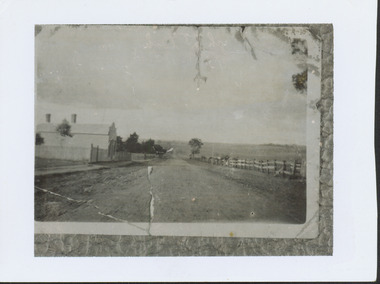
Photograph - High Street looking north to Burke Road, 1907-08
While a number of subdivisions of what was to become Kew East occurred in the 1880s, such as the 'Mount Pleasant Estate' (1888) and 'Monterey Estate' (1888), Glynn's Lot 91 remained open farmland until the Harp Estate (1912) was sold, hence the undeveloped nature of the view in 1907-8.A rare image of the open farmland in the eastern part of Kew looking towards Burke Road in 1907-8.Damaged, and very rare, black & white photograph of what was to become the suburb of East Kew, taken by a member of the Bennett family in 1907-8. The photograph is taken from the Harp of Erin Hotel showing, apart from a building on the left (no longer extant), fenced open farmland stretching into the far distance.HIGH ST LOOKING NOTRTH TO BURKE RD FROM HARP / EDWD GLYNN'S LOT 91 FROM 1851 / GIFT FROM BENNETT FAMILY 22 HARP RD EAST KEW 1980 / 1907-8harp of erin, high street -- east kew (vic), harp estate -
 Kew Historical Society Inc
Photograph - 8 Kellett Grove, North Kew, 1929
North Kew, now divided between Kew and Kew East, bordered the Yarra River. As such, it was a region subject to flooding in the Yarra Valley. Development beyond this point (ie Kellett Grove) was limited by the City of Kew's planning regulations. Prior to urban development, the area since European settlement and the first land sales in the district in the 1840s, had been used for dairy farming. Small sepia snapshot taken of the front of 8 Kellett Grove, in what was then known as North Kew. Verso: 8 KELLETT GROVE / NORTH KEW / 1929 / 418 kellett gove -- north kew, californian bungalows, houses -- kellett grove -- kew (vic.) -
 Kew Historical Society Inc
Slide - House, cnr Fellows and Barry Streets, 1979
One of a group of slides taken by members of the Society of built heritage in Kew in 1979-80. The selection of subject matter reflects the priorities of the period. The colour of some slides has degraded. This particular slide is of 'Fairholme' on the corner of Barry and Fellows Street. The building is listed by the National Trust (Victoria). The citation on the Historic Buildings Register states: 'Fairholme is of State architectural significance as a distinctive free Romanesque Revival residence. Built in two stages, 1889 for solicitor Edward Smart and early this century for importer, J K Meritt, the singular architectural character of Fairholme is achieved by combining window bays and groups of windows with a two-storey gabled porch. The deliberate and distinctively asymmetrical composition is emphasised by Art Nouveau pressed cement detailing (coprosma) on a bowed balcony and the two-storey timber verandah, which is typical of the Edwardian period. The architects were Reed, Henderson & Smart (1889) and C Gordon McCrae (c 1900-1). Internally a grand entry hall with inglenook, staircase and gallery follow the Arts and Crafts quality of the exterior. Classified: 17/03/1993'The slides represent a snapshot in time of built architecture in Kew, much of which has changed in the forty-plus period since they were created. 35mm colour transparency (slide) of 'Fairholme' (1889) on the north-east corner of the intersection of Fellows and Barry Streets, Kew. The photo was developed in May 1979.barry street -- kew (vic.), fellows street -- kew (vic.), historic houses -- kew (vic.), architects -- reed henderson & smart, architectural styles -- romanesque revival, j k merritt -
 Kew Historical Society Inc
Photograph - 'Reno', 10 St John's Parade, John T Collins, 1977
‘Reno’, stood on the east side of St John’s Parade. Its earliest recorded owner was the architect Samuel Cocking who lived there from c.1865 until his death in 1888. The original landholding was bordered by Cotham Road, Glenferrie Road, Wellington Street, and Charles Street. The southern portion of this land included a fine orchard, with many imported trees. The old summer house, at first in the orchard, was later removed to the house garden. The MMBW Detail Plan No.1576 (1904) shows the remaining portion of the original land holding, including a semi-circular pathway at the front, and garden features such as an aviary, a fountain and grotto, and a fernery. The garden including rare plants supplied by Baron Von Mueller, surrounds the cottage in a tangled frenzy. Despite a ‘local significance’ classification by the National Trust, the house was demolished in 1977.Partial view, north side of the weatherboard cottage in St John's Parade, Kew, known as 'Reno' (demolished 1977). Architectural elements revealed in this photo by John T Collins include: two wing, hip roof construction; external buildings at angles to main wing; corrugated iron roofing [over shingles]; brick chimney external to building; unvarnished/unpainted external weatherboards. General dilapidated condition. "Kew 'Reno' 10 St Johns Pde / John Collins, 11 Anderson Road, Hawthorn East, 3123, Film 35B Exposure 27"reno - st john's parade -- kew (vic.), john t collins -
 Kew Historical Society Inc
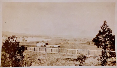
Photograph - Yarra in Flood - Belford & Kilby Farms, 1903
In 1980, Mr Laurie Bennett presented the Kew Historical Society with a number of photographs and postcards from the estate of his mother Eileen Mary Bennett (nee Clark). His mother was the daughter of Lawrence FH Clark(?-1946) and Mary Clark (?-1925) of 22 Harp Road, East Kew, in whose yard the photograph was taken. A year before the donation occurred a notice appeared in the Canberra Times stating that: "BENNETT, Eileen Mary. — May 8th at Tuross Heads, N.S.W. Late of 22 Harp Rd, East Kew, (Vic). Dearly loved wife of the late Harold Bennett, loved mother and mother in law of Laurie and Shirley (Melbourne), Kevin and Doreen (Canberra), grandmother of Linda, Stephen, Paul, Gabrielle, Peter, Mark and Jon."Part of a large collection of photographs and postcards in the collectionPanoramic photographic positive of North Kew where the Belford and Kilby Farms were located on the south side of the Yarra River. This photo, donated in 1980 by Laurie Bennett is the original of the two identical photos in the collection.laurie bennett, eileen mary bennett, eileen mary clark, floods -- yarra -- 1903