Showing 233 items
matching old post office hill
-
 Ballarat Heritage Services
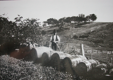
Photograph, Cleaning Wine Barrells at the Gervasoni Vineyard, Yandoit Creek
Luigi Gervasoni was born in San Gallo, Lombardy, Italy. He arrived in Australia in 1863 and was part of a co=operative to farm and build the old stone house at Yandoit Creek. Eventually moving to his own property he was a vigneron selling his wine in central Victoria and Melbourne, and exporting to Ireland. Black and white photograph of wine barrells being cleaned at Yandoit Creek, Victoriayandoit creek, vineyard, barrell, gervasoni -
 Ballarat Heritage Services
Photograph, Kathleen Gervasoni, Birthday Party, November 1971, 1971
Colour photograph of Lisa Gervasoni's second birthday party held at 93 Willsmere Road Kew (behind North Kew Newsagency). Left to right: Clare Gervasoni (in the old summer uniform of St Anne's East Kew), Lisa Gervasoni, and Ann Gervasoni (in the new summer uniform of St Anne's East Kew).birthday, gervasoni, birthday cake, st anne's east kew uniform, st anne's east kew -
 Ballarat Heritage Services
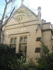
Photograph - Colour, Clare Gervasoni, University of Melbourne Old Physics Building, 2010, 29/09/2010
... Ballarat Heritage Services PO Box 2209 Bakery Hill Post ...Melbourne University Old Physics Building (1889) was designed by Reed, Henderson and Smart. It later house the Univesity's Centre for Indigenous Education and a conference centre (2010).Colour photograph of the Melbourne University Old Physics Building.university of melbourne, old physics building -
 Ballarat Heritage Services
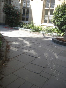
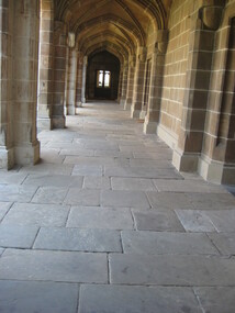
Photograph - Colour, Clare Gervasoni, Flagstones at the University of Melbourne Old Physics Building, 2010, 29/09/2010
... Ballarat Heritage Services PO Box 2209 Bakery Hill Post ...Melbourne University Old Physics Building (1889) was designed by Reed, Henderson and Smart. It later house the Univesity's Centre for Indigenous Education and a conference centre (2010).Colour photograph of the flagstones at the Melbourne University Old Physics Building.university of melbourne, old physics building, flagstones -
 Ballarat Heritage Services
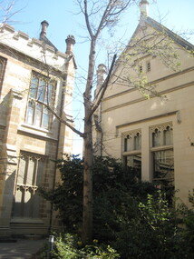
Photograph - Colour, Clare Gervasoni, University of Melbourne Old Physics Building, 2010, 29/09/2010
... Ballarat Heritage Services PO Box 2209 Bakery Hill Post ...Melbourne University Old Physics Building (1889) was designed by Reed, Henderson and Smart. It later house the Univesity's Centre for Indigenous Education and a conference centre (2010).Colour photograph of the Melbourne University Old Physics Building.university of melbourne, old physics building -
 Ballarat Heritage Services
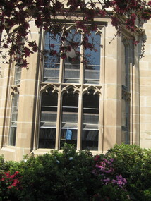
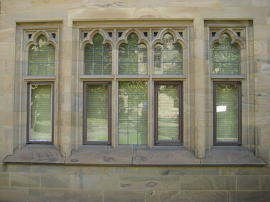
Photograph - Colour, Clare Gervasoni, University of Melbourne Old Physics Building, 2010, 29/09/2010
... Ballarat Heritage Services PO Box 2209 Bakery Hill Post ...Melbourne University Old Physics Building (1889) was designed by Reed, Henderson and Smart. It later house the Univesity's Centre for Indigenous Education and a conference centre (2010).Colour photograph of the windows of the Melbourne University Old Physics Building.university of melbourne, old physics building -
 Ballarat Heritage Services
Photograph - Colour, Clare Gervasoni, University of Melbourne Old Law Building, 2010, 29/09/2010
... Ballarat Heritage Services PO Box 2209 Bakery Hill Post ...Melbourne University Old Physics Building (1889) was designed by Reed, Henderson and Smart. It later house the Univesity's Centre for Indigenous Education and a conference centre (2010).Colour photograph of the windows of the Melbourne University Old Physics Building.A plaque on the wall of this building states: In April, 1856 stonemasons woking on this building downed tools, marched to the city and inaugrated a movement which win the Eight Hour Day for building workers in Victoria. The victory became an international landmark in the history of the labour movement. university of melbourne, old law building, eight hour day, stonemasons -
 Ballarat Heritage Services
Photograph - Colour, Clare Gervasoni, Flagstones at the University of Melbourne Old Law Building, 2010, 29/09/2010
... Ballarat Heritage Services PO Box 2209 Bakery Hill Post ...Melbourne University Old Physics Building (1889) was designed by Reed, Henderson and Smart. It later house the Univesity's Centre for Indigenous Education and a conference centre (2010).Colour photograph of the windows of the Melbourne University Old Physics Building.A plaque on the wall of this building states: In April, 1856 stonemasons woking on this building downed tools, marched to the city and inaugrated a movement which win the Eight Hour Day for building workers in Victoria. The victory became an international landmark in the history of the labour movement. university of melbourne, old law building, eight hour day, stonemasons -
 Ballarat Heritage Services
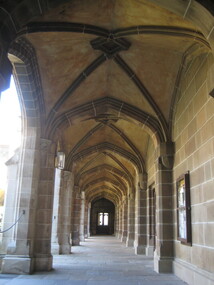
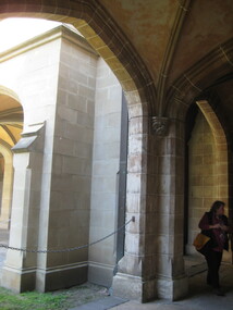
Photograph - Colour, Clare Gervasoni, University of Melbourne Old Law Building, 2010, 29/09/2010
... Ballarat Heritage Services PO Box 2209 Bakery Hill Post ...Melbourne University Old Physics Building (1889) was designed by Reed, Henderson and Smart. It later house the Univesity's Centre for Indigenous Education and a conference centre (2010).Colour photograph of the windows of the Melbourne University Old Physics Building.A plaque on the wall of this building states: In April, 1856 stonemasons woking on this building downed tools, marched to the city and inaugrated a movement which win the Eight Hour Day for building workers in Victoria. The victory became an international landmark in the history of the labour movement. Another plaque reads: This, the original building of the University was built of Tasmanian freestone between 1854 and 1857 to the design of F.M. White, architect. It was for many years the University's administrative centre, library, lecture rooms, and professorial residences. The east and west wings were extended in 1930 to the design of J.S. Gawler. In 1969, the quadrangle was completed by the addition of the southern wing which contains the council chamber, designed by R.E. Featherstone. university of melbourne, old law building, eight hour day, stonemasons, tasmanian freestone, f.m. white, j.s. gawler, r.e. featherstone -
 Ballarat Heritage Services
Photograph - Colour, Clare Gervasoni, University of Melbourne Old Law Building, 2010, 29/09/2010
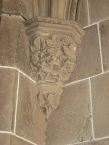
... Ballarat Heritage Services PO Box 2209 Bakery Hill Post ...Melbourne University Old Physics Building (1889) was designed by Reed, Henderson and Smart. It later house the Univesity's Centre for Indigenous Education and a conference centre (2010).Colour photograph of the windows of the Melbourne University Old Physics Building.A plaque on the wall of this building states: In April, 1856 stonemasons woking on this building downed tools, marched to the city and inaugrated a movement which win the Eight Hour Day for building workers in Victoria. The victory became an international landmark in the history of the labour movement. Another plaque reads: This, the original building of the University was built of Tasmanian freestone between 1854 and 1857 to the design of F.M. White, architect. It was for many years the University's administrative centre, library, lecture rooms, and professorial residences. The east and west wings were extended in 1930 to the design of J.S. Gawler. In 1969, the quadrangle was completed by the addition of the southern wing which contains the council chamber, designed by R.E. Featherstone. A third plaque states: These cloisters, commenced in 1853 and extended in 1930 nd 1969 were completed in 1981 through the generosity of the late Edward Stevens, a member of Council from 1926 until 1939. The work was also supported by the Wilson Trust and Sir Wilfred Brookes.university of melbourne, old law building, eight hour day, stonemasons, tasmanian freestone, cloisters, edward stevens, wilson trust, wildred brookes -
 Ballarat Heritage Services
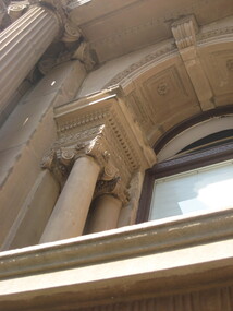
Photograph - Colour, Clare Gervasoni, University of Melbourne Old Commerce Building, 2010, 29/09/2010
... Ballarat Heritage Services PO Box 2209 Bakery Hill Post ...Melbourne University Old Physics Building (1889) was designed by Reed, Henderson and Smart. It later house the Univesity's Centre for Indigenous Education and a conference centre (2010).Colour photograph of The Old Commerce Building, later part of Architecture. An 1856 Reed designed Bank of New South Wales faced was incorporated into the original 1940 building. university of melbourne, old law building, eight hour day, stonemasons, tasmanian freestone, cloisters, edward stevens, wilson trust, wildred brookes -
 Ballarat Heritage Services
Photograph - Colour, Old Sarum, England, 2017, 01 November 2016
William the Conqueror inherited Old Sarum from the last Saxon king of England. It was an ideal site for a royal castle. It was here in 1070 that William paid off his army after a long and bitter campaign in northern England. It was here in 1086 that he called together all the major landholders in England so they could swear allegiance to him. It was a crucial moment. The Domesday Book was being written, a threatened Viking invasion had only just been averted and William's eldest son was in armed rebellion. Old Sarum was an important place where this Norman king of England held power. In 1794 the Ordnance Survey set out to check the accuracy of the first mapping of Southern England, which had begun ten years earlier. From a point just below Old Sarum Lieutenant William Mudge laid out a base-line 36,574 feet (11,253 metres) long. From each end of the line the positions of distant places were plotted using a huge theodolite made in 1791 by Jesse Ramsden. The accuracy of the process, which was repeated all over England, depended on Jesse Ramsden's craftsmanship and on William Mudge's surveying skill in setting out this first base-line from Old Sarum. The nearer end of Mudge's line is marked by an inscribed stone beside the modern A345 at Old Sarum. ordnance survey, william mudge, jesse ramsden, william the conqueror, old sarum, saxon, 1086, england -
 Ballarat Heritage Services
Photograph - Photograph - Colour, Old Sarum, England, 2016, 01/11/2016
William the Conqueror inherited Old Sarum from the last Saxon king of England. It was an ideal site for a royal castle. It was here in 1070 that William paid off his army after a long and bitter campaign in northern England. It was here in 1086 that he called together all the major landholders in England so they could swear allegiance to him. It was a crucial moment. The Domesday Book was being written, a threatened Viking invasion had only just been averted and William's eldest son was in armed rebellion. Old Sarum was an important place where this Norman king of England held power. In 1794 the Ordnance Survey set out to check the accuracy of the first mapping of Southern England, which had begun ten years earlier. From a point just below Old Sarum Lieutenant William Mudge laid out a base-line 36,574 feet (11,253 metres) long. From each end of the line the positions of distant places were plotted using a huge theodolite made in 1791 by Jesse Ramsden. The accuracy of the process, which was repeated all over England, depended on Jesse Ramsden's craftsmanship and on William Mudge's surveying skill in setting out this first base-line from Old Sarum. The nearer end of Mudge's line is marked by an inscribed stone beside the modern A345 at Old Sarum. Colour photograph of Old Sarum, England.ordnance survey, william mudge, jesse ramsden, william the conqueror, old sarum, saxon, 1086, england -
 Ballarat Heritage Services
Photograph - Colour, Earth Banks, Old Sarum, England, 01 November 2016
William the Conqueror inherited Old Sarum from the last Saxon king of England. It was an ideal site for a royal castle. It was here in 1070 that William paid off his army after a long and bitter campaign in northern England. It was here in 1086 that he called together all the major landholders in England so they could swear allegiance to him. It was a crucial moment. The Domesday Book was being written, a threatened Viking invasion had only just been averted and William's eldest son was in armed rebellion. Old Sarum was an important place where this Norman king of England held power. In 1794 the Ordnance Survey set out to check the accuracy of the first mapping of Southern England, which had begun ten years earlier. From a point just below Old Sarum Lieutenant William Mudge laid out a base-line 36,574 feet (11,253 metres) long. From each end of the line the positions of distant places were plotted using a huge theodolite made in 1791 by Jesse Ramsden. The accuracy of the process, which was repeated all over England, depended on Jesse Ramsden's craftsmanship and on William Mudge's surveying skill in setting out this first base-line from Old Sarum. The nearer end of Mudge's line is marked by an inscribed stone beside the modern A345 at Old Sarum. ordnance survey, william mudge, jesse ramsden, william the conqueror, old sarum, saxon, 1086, england -
 Ballarat Heritage Services
Photograph - Colour, Dorothy Wickham, Earth Banks, Old Sarum, England, 2016, 01 November 2016
William the Conqueror inherited Old Sarum from the last Saxon king of England. It was an ideal site for a royal castle. It was here in 1070 that William paid off his army after a long and bitter campaign in northern England. It was here in 1086 that he called together all the major landholders in England so they could swear allegiance to him. It was a crucial moment. The Domesday Book was being written, a threatened Viking invasion had only just been averted and William's eldest son was in armed rebellion. Old Sarum was an important place where this Norman king of England held power. In 1794 the Ordnance Survey set out to check the accuracy of the first mapping of Southern England, which had begun ten years earlier. From a point just below Old Sarum Lieutenant William Mudge laid out a base-line 36,574 feet (11,253 metres) long. From each end of the line the positions of distant places were plotted using a huge theodolite made in 1791 by Jesse Ramsden. The accuracy of the process, which was repeated all over England, depended on Jesse Ramsden's craftsmanship and on William Mudge's surveying skill in setting out this first base-line from Old Sarum. The nearer end of Mudge's line is marked by an inscribed stone beside the modern A345 at Old Sarum. King William devised the Domesday Book, considered to be the first listing of land owners in England. Among the names is that of D'Arques, from Normandy, France. Descendants of this family later emigrated from England and settled in Victoria, Australia under the surname 'Dark'. ordnance survey, william mudge, jesse ramsden, william the conqueror, old sarum, saxon, 1086, england -
 Ballarat Heritage Services
Photograph - Colour, Earth Banks, Old Sarum, England, 2016, 01 November 2016
William the Conqueror inherited Old Sarum from the last Saxon king of England. It was an ideal site for a royal castle. It was here in 1070 that William paid off his army after a long and bitter campaign in northern England. It was here in 1086 that he called together all the major landholders in England so they could swear allegiance to him. It was a crucial moment. The Domesday Book was being written, a threatened Viking invasion had only just been averted and William's eldest son was in armed rebellion. Old Sarum was an important place where this Norman king of England held power. In 1794 the Ordnance Survey set out to check the accuracy of the first mapping of Southern England, which had begun ten years earlier. From a point just below Old Sarum Lieutenant William Mudge laid out a base-line 36,574 feet (11,253 metres) long. From each end of the line the positions of distant places were plotted using a huge theodolite made in 1791 by Jesse Ramsden. The accuracy of the process, which was repeated all over England, depended on Jesse Ramsden's craftsmanship and on William Mudge's surveying skill in setting out this first base-line from Old Sarum. The nearer end of Mudge's line is marked by an inscribed stone beside the modern A345 at Old Sarum. ordnance survey, william mudge, jesse ramsden, william the conqueror, old sarum, saxon, 1086, england -
 Ballarat Heritage Services
Photograph - Photograph - Colour, Castle toilets, Old Sarum, England, 2016, 01/11/2016
William the Conqueror inherited Old Sarum from the last Saxon king of England. It was an ideal site for a royal castle. It was here in 1070 that William paid off his army after a long and bitter campaign in northern England. It was here in 1086 that he called together all the major landholders in England so they could swear allegiance to him. It was a crucial moment. The Domesday Book was being written, a threatened Viking invasion had only just been averted and William's eldest son was in armed rebellion. Old Sarum was an important place where this Norman king of England held power. In 1794 the Ordnance Survey set out to check the accuracy of the first mapping of Southern England, which had begun ten years earlier. From a point just below Old Sarum Lieutenant William Mudge laid out a base-line 36,574 feet (11,253 metres) long. From each end of the line the positions of distant places were plotted using a huge theodolite made in 1791 by Jesse Ramsden. The accuracy of the process, which was repeated all over England, depended on Jesse Ramsden's craftsmanship and on William Mudge's surveying skill in setting out this first base-line from Old Sarum. The nearer end of Mudge's line is marked by an inscribed stone beside the modern A345 at Old Sarum. Colour photographs of Castle toilets at Old Sarum, England. The toilets are constructed of stone. ordnance survey, william mudge, jesse ramsden, william the conqueror, old sarum, saxon, 1086, england, subjects, toilets -
 Ballarat Heritage Services
Photograph, Lisa Gervasoni, Old Skipton Pre Olympic Swimming Pool, 2010 - 2017
Pre olympic swimming poolColour photograph of the Old Skipton Swimming Pool.swimming, pool, sport, pre olympic, skipton, lake, skiton swimming pool -
 Ballarat Heritage Services
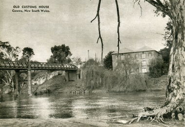
Photograph - Image - Black and White, Old Customs House at Corowa, c1950, c1950
A black and white image of the Old Customs House at Corowa.corowa, customs house, river, bridge -
 Ballarat Heritage Services
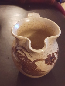
Ceramic - Artwork - Ceramics, Pottery Jug by Gellibrand Pottery
Jon and Alda Hubbard were operating Gellibrand Pottery around the late 1980s on the Old Beech Forrest Road in Gellibrand near Colac in the Otway region.Photo of a hand thrown jug with glaze decoration. It is stamped (impressed) "Gellibrand Pottery". ceramics, pottery, gellibrand pottery, studio pottery -
 Ballarat Heritage Services
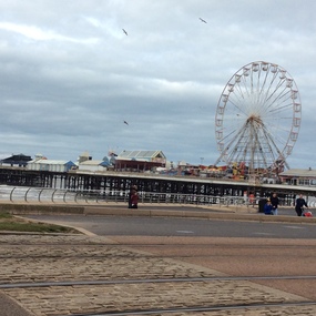
Digital photographs, Blackpool 2016, 2016
Black pool was one of the first seaside towns to experience middle and lower class visitations in the Edwardian period. The Blackpool tower is noted as an iconic landscape. "Blackpool is a seaside resort on the Irish Sea coast of England. It's known for Blackpool Pleasure Beach, an old-school amusement park with vintage wooden roller coasters. Built in 1894, the landmark Blackpool Tower houses a circus, a glass viewing platform and the Tower Ballroom, where dancers twirl to the music of a Wurlitzer organ. Blackpool Illuminations is an annual light show along the Promenade. Weather: 8 °C, Wind SE at 18 km/h, 81% Humidity Local time: Wednesday 8:44 am Postcode: FY1-FY4" wikipediaDigital images in colour -
 Ballarat Heritage Services
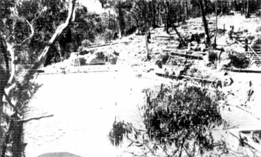
Photograph - Image - Black and White, Hepburn Swimming Pool, 1936, 1936
The Hepburn Pool was built in Spring Creek during the 1930s by the Zelman's of Bellinzona Guest House. Alberto Zelman's paid for local workers to construct the pool to their specifications so the visitors to local guest houses could swim on hot days. The Hepburn Pool was used for the Victorian Swimming Championships, with 6 stones marked at one end for each lane . It is 50 yards long, the length required for competitions. In 1969 the Daylesford Olympic Swimming Pool was constructed so this 'old swimming pool' was neglected, fortunately in 1993 local volunteers associated with the Savoia Hotel returned the pool to its former glory with the help of old photos and a lot of hard work. Two well known swimmers swam at the pool in the Victorian swimming Championships, they were Annette Kellerman and Frank Beaurepaire. The Pool was named Victoria's Favourite Built Place in 2004 as part of the Victorian Government's involvement in the International Year of the Built Environment. It was included on the Victorian Heritage Register following a nomination and comparative analysis of pre Olympic Swimming Pools in Victoria by Lisa Gervasoni.Black and white imageof the Hepburn Pool in Spring Creek, with spectators on the hill. hepburn springs swimming pool, hepburn springs, hepburn pool, pre-olympic swimming pools, albert zelman, bellinzona, pre-0lympic swimming pool -
 Ballarat Heritage Services
Photograph - Photograph - Colour, Corner of Vickers Street and Albert Street, Sebastopol, 2020, 07/04/2020
The South Star Mine commenced operations in the 1880s and worke the quartz laods after the great floods of 1875 forced the closure of most alluvial mines. The South Star Mine sunk its first shaft in 1886, but broke into old alluvial workings and had to be abandoned because of flooding. The second shaft commenced in 1887, and was the deepest eer sunk in the Ballarat district, reaching 956 metres. 180 men worked three shifts each day.Colour photograph of the site of the South Star Mine in Sebastopol. sebastopol, albert street, south star mine, mining -
 Ballarat Heritage Services
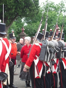
Photograph - Eureka Commemoration at the Ballaarat Old Cemetery, Cr Judy Verlin inspects the 40th Regiment reenactors on Eureka Sunday 2008, 12/2008
Two colour photographs of inspection of the 40th Regiment by Cr Judy Verlin. The event took place on Eureka Sunday in the Ballaarat Old Cemetery. Doug Sera is seen in the background,eureka stockade, eureka sunday, 40th regiment, ballaarat old cemetery, commemoration