Showing 23893 items
matching orbost-railway-station
-
 Ringwood and District Historical Society
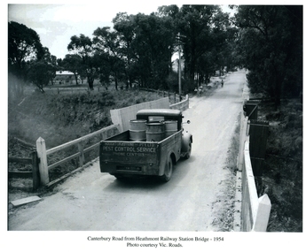
Photographs / Album Pages, Canterbury Road from Heathmont Railway Station Bridge 1954, 1954
Houghton & Byrne Pest Service Truck on Canterbury Road crossing Heathmont Railway Station Bridge 1954. Photo courtesy Vic. RoadsCanterbury Road from Heathmont Railway Station Bridge - 1954. Photo courtesy Vic. Roads -
 Kew Historical Society Inc
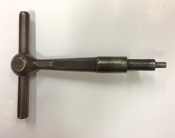
Equipment, Victorian Railways, 'A' Pattern Annett Key : Kew Railway Station, 20th Century
Kew Railway Station was the second railway station on the Kew 'Spur' Line in Melbourne. The key unlocked signals equipment at the Station. The key was donated by Harry Jackson in 2019 during an exhibition at the Kew Court House on railway history in Kew.This piece of railway equipment is a rare oiece of railway memorabilia.'A' pattern Annett Key, used at the Kew Railway Station with signals equipment.KEWkew railway station - denmark street - kew (vic), annett keys -
 Sunbury Family History and Heritage Society Inc.
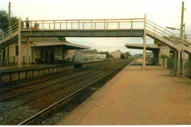
Photograph, c
The photograph shows a view of Sunbury Railway station as it was in the 1970s and earlier. he image is looking south to the railway crossing at Station Street and the storage sheds which were along Platform 1, where the trains for Melbourne left.A coloured photograph of a railway station and pedestrian bridge.sunbury -
 Orbost & District Historical Society
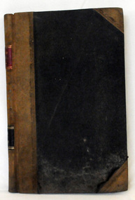
cash book, 1905 - 1914
This ledger was used by the Shire of Orbost pound keeper from 1906 - 1914. The item was donated to Orbost & District Historical society from P.R.O.V. as a Place of Deposit (POD) item for safe keeping by a local history group or museum. The shire covered an area of 9,347 square kilometres and existed from 1892 until 1994 when it became part of the East Gippsland Shire Council. Orbost was at first included in the Bairnsdale Shire from 1882 and was later part of the Tambo Shire. Because of travelling distances the Croajingalong Shire was created in 1892 (name changed to Orbost Shire 17.2.1893 with James Cameron as the first Shire President. In 1994 it amalgamated to become part of East Gippsland Shire Council. This book records the impounding of animals which have been found wandering on local roads or trespassing on land. Many are farm animals. Impounded animals were either claimed by their owners after payment of a fee or if unclaimed , they were sold. The Orbost Pound was situated on Martin Street.This book is a record of a practice which was necessary to remove stock which were wandering on local roads or trespassing on neighbours. It contains many local names and is of social interest. (ref. Vic. Collections)A ledger with a black cover, brown binding. The page edges are marbled. It contains hand-written records of payments received by the treasurer of the Orbost Pound.on spine : inside a red box in gold lettering"Pound Cash Book" inside a black box in gold lettering"Shire of Orbost"orbost-shire-council orbost-pound accounts cash-book -
 Orbost & District Historical Society
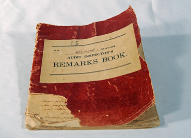
Victorian Railways remarks book, Victorian Railways, c. 1940s
Used at Orbost Railway Station, possibly by the Station Master, between 1944 and 1984. The Bairnsdale-Orbost railway was opened in 1916 to serve the agricultural and timber industry. Because of the decline in traffic and heavy operating costs, the line was finally closed in August, 1987. Orbost Railway Station was opened on Monday 10 April 1916 as the terminus of the Orbost railway line, and closed in 1987. The station was located on the west side of the Snowy River despite the town of Orbost being on the east side of the river, in order to save on the costs of a bridge over the river, which at the time had highly variable levels. This item is associated with the history of the Orbost-Bairnsdale railway line and therefore reflects the role that the rail line played in the social and economic history of Orbost.Book with a red cover. On the front cover VICTORIAN RAILWAYS Audit Inspectors Remarks Book, Orbost. Inside are numbered and lined pages with hand written information dating from 28/3/1944-13/8/1984, dated and signed by various station masters. Cover has a section missing from the bottom left.VICTORIAN RAILWAYS Audit Inspectors Remarks Book, Orbost.railway-history orbost-bairnsdale-railway -
 Linton and District Historical Society Inc
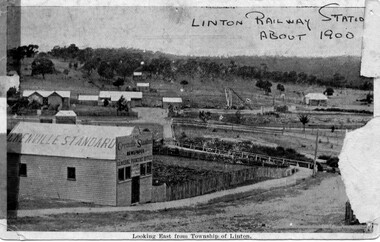
Photograph, Grenville Standard and Linton Railway Station buildings, c.1900
The 'Grenville Standard' was Linton's newspaper from 1895-1941. The railway arrived at Linton in 1891. Black and white postcard photograph of view looking east from Clyde Street in Linton township. 'Grenville Standard' building prominent in foreground, railway buildings and machinery, and station-master's house, in middle ground. Hills rising behind, with two or three cottages, and trees."Linton Railway station about 1900" hand printed across top of photograph. "Looking East from Township of Linton" printed beneath picture.grenville standard [newspaper], linton railway station, buildings, station master's house linton -
 Orbost & District Historical Society
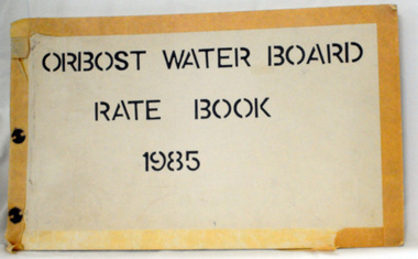
rate books, 1981 -1984
The Orbost Waterworks Trust was constituted under the Water Act 1915 and the Water Act 1916 and gazetted 10th Jan 1917. The Trust consisted of six members who were responsible for the provision of reticulated water to meet the needs of the town. The first reticulated supply to Orbost was installed about 1920. The Trust became part of the Orbost Water Board constituted under the Water and Sewerage Authorities (Restructuring Act) 1983. From 1995 the area has been served by the East Gippsland Region Water Authority. The East Gippsland Region Water Authority was constituted on January 1, 1995. The new Authority assumed responsibility for the services previously provided by the Mitchell Water Board, the Tambo Water Board, the Orbost Water Board and the Mallacoota Water Board. East Gippsland Water is the registered business name of the East Gippsland Region Water Authority. (info. from P.R.O.)These rate books are historically significant as records of an authority which no longer exists having been absorbed by the East Gippsland Water Authority,Four books which contain records of the Orbost Water Board. Each has a hand-made cardboard cover with split pins to hold the pages. The pages are carbon copies and are computer generated. 2551.1 -1981; 2551.2 - 1982 ; 2551.3 - 1983 ; 2551.4 - 1984on front covers : "ORBOST WATER BOARD RATES BOOK" with the year below. -
 Stawell Historical Society Inc
Photograph, Railway Station Stawell
Stawell railway Station with horse and buggy in front. Large trees to left of photo. Engraved "Railway Station Stawell 12.B/W/ Photgraph of the Stawell Railway Station. form the front, A large tree to the left of the station, also a Horse and Trap, also a Gaslight.stawell railways transport, mark dadswell -
 Whitehorse Historical Society Inc.
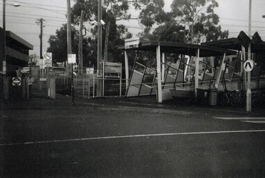
Photograph, The Railway Crossing from Corner of Springvale Road & Station, 1/06/2009
One of a collection of photographs taken of the Nunawading Railway Station prior to the lowering of the railway line and building of the new railway station on the western side of Springvale Road so that the Springvale Road Rail Crossing can be eliminated.Black & white photograph of he precinct surrounding the Nunawading Station and the Springvale Road Railway crossing. This photograph is of the Railway Crossing from corner of Springvale Road & Station. See NP 3545 to NP3567for the complete set of photographsnunawading railway station, springvale road, nunawading, redevelopment of railway line/springvale road., station street nunawading -
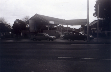
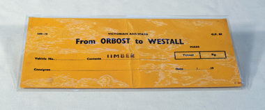 Orbost & District Historical Society
railways envelope, Victorian Railways, c. 1970s-1980s
Used at Orbost railway station for the consignment of goods/freight, in this case, timber to Westall. The Bairnsdale-Orbost railway was opened in 1916 to serve the agricultural and timber industry. Because of the decline in traffic and heavy operating costs, the line was finally closed in August, 1987. Orbost Railway Station was opened on Monday 10 April 1916 as the terminus of the Orbost railway line, and closed in 1987. The station was located on the west side of the Snowy River despite the town of Orbost being on the east side of the river, in order to save on the costs of a bridge over the river, which at the time had highly variable levels. This item is associated with the history of the Orbost-Bairnsdale railway line and therefore reflects the role that the rail line played in the social and economic history of Orbost.An unused brown/buff coloured goods/freight consignment envelope used by Victorian Railways, this one for timber from Orbost to Westall. 2498-78 VICTORIAN RAILWAYS From ORBOST to WESTALL Contents TIMBER railway-history orbost-bairnsdale-railway -
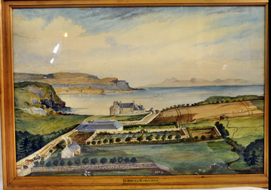 Orbost & District Historical Society
Painting, Blackney, I, Orbost - Isle of Sky - Scotland
This picture was donated by , Col & Mrs Swire after visiting Orbost Vic. They came from Orbost in the Isle Of Skye. The original watercolour was painted circa 1845 by Ann Lyon-Mackenzie.This painting has aesthetic significance and an association with the history of Orbost.A large watercolour reproduction picture of a property called Orbost on the Isle of Skye, Scotland. Gold frame with glass.Front - Orbost in the Isle of Sky, Scotlandwatercolour orbost isle-of-skyelyon-mackenzie-ann -
 Stawell Historical Society Inc
Photograph, Railway Station Stawell Looking Across the Tracks
Two colour photographs Stawell Railway Station when used as Bus Station Feb 1995B/W Photograph of the Stawell Railway Station Looking acroos the tracks at the Platformstawell railways transport -
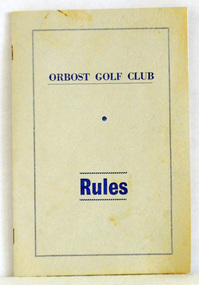 Orbost & District Historical Society
booklet, Snowy River Mail as "Mail" Print, Orbost Golf Club Rules, 1968
Published by the Orbost Golf Club.The golf club was established in 1906 it was originally formed as the Snowy River Golf Club and played on private land near the banks of the Snowy River just to the south of town. In the 1930’s the Golf Club relocated to its present site and was renamed Orbost Golf Club. The land was shared by the Show grounds and Racing Club. Orbost Golf Club later acquired the land outright to provide a permanent home for golfers in Orbost and surrounding district.A thin, 24pp booklet with a grey cover titled "Orbost Golf Club Rules". It contains the rules of the Orbost Golf Club and has a loose sheet with amendments. The cover has blue print.orbost-golf-club recreation sport golf -
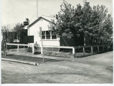 Orbost & District Historical Society
black and white photograph, 1960s - 1970s
This photograph shows the former Orbost Police Station in Wolseley Street before it was demolished and a new larger brick building was built behind it in Lawson Lane - late 1980s.This is a pictorial record of a significant community building no longer existing.A large black / white photograph of the Orbost township police station. It is a weatherboard building surrounded by trees. A sign "POLICE" is hanging from a pole.on back - " Orbost Police Station in Wolseley Street, Donated by Debbie Hall 31/8/94"orbost-police-station -
 Ballarat Heritage Services
Digital photographs, L.J. Gervasoni, Koroit Railway Station, 2016
Digital imagestransport, rail trail, koroit, koroit railway station, goods shed, siding, metal, nails -
 Ballarat Heritage Services
Photograph - Digital photographs, L.J. Gervasoni, Koroit Railway Station Timetable, 2016
Digital imagestransport, rail trail, koroit, koroit railway station, timetable -
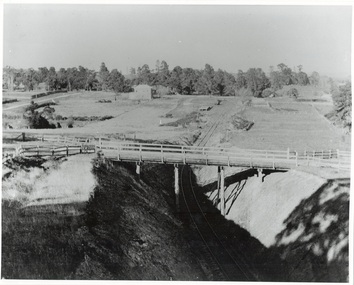 Buninyong & District Historical Society
Photograph - Photo of Original Photograph, W. Jack, Buninyong Railway Station precinct in 1940, 9 June 1940
Railway station and surrounds in 1940.B/W photograph f Buninyong Railway station precinct, taken 9 June 1940, showing Barkly St. trestle bridge over railway cutting, Butter Factory on left, station and rail yards on left, township to thye right.buninyong, railway, bunny, butter factory, bridge, cutting, barkly st. -
 Victorian Interpretive Projects Inc.
photograph, Opening of the bew building at Stratford Railway Station, Victoria, c1921, c1921
Stratford railway station is located on the Bairnsdale line in Victoria, Australia. The railway lined opened on 8 November 1887 it served the town of Stratford. The building at the Stratford Railway Station was opened around 1921 after the original building was destroyed by fire on 10 January 1920. "STRATFORD RAILWAY STATION. Mr. M'Lachlan, M.L.A., has received the following from Mr. Norman, late Chairman of the Railway Commissioners:-"In reply to yours, I beg to state that material for the new Stratford railway station has been ordered, and the work will be put in hand as soon as it has been delivered. It is not an easy matter at the present time to obtain materials, and I cannot say exactly when those required will be received." (Gippsland Times, 27 September 1920) Until their demolition, Munro, Fernbank, Lindenow and Hillside stations were located between Stratford and Bairnsdale stations. (wikipedia)Photograph of two postcards showing a crowd at Stratford Railway Station to celebrate the opening of the new building. stratford, stratford railway station, railway -
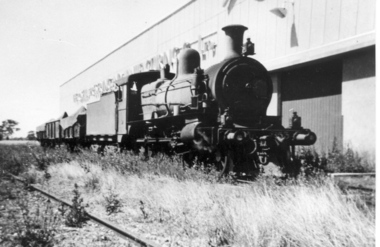 Tatura Irrigation & Wartime Camps Museum
Photograph, Tatura Railway station
Three photos of Tatura Railway station & one of the Rosella Siding, with steam engines.Three photos of Tatura Railway station & one of the Rosella Siding, with steam engines. -
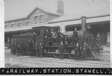 Stawell Historical Society Inc
Photograph, E Class Steam Engine in front of Stawell Railway Station c1880
Engine E Class 345 Photo late 1880's to 1890's?Steam Engine in front of Station with about 12 Gentlemen in suites.Railway Station Stawell R A Leslie Art Photographerrailways -
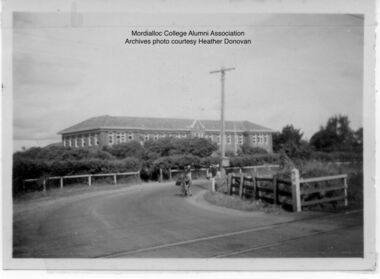 Mordialloc College Alumni Association Inc (MCAA)
Photograph, 1954 Mordialloc-Chelsea High School and Station Street Railway Crossing Aspendale, 1954
Station Street Railway Crossing and Mordialloc-Chelsea High School. Photo courtesy of past student Heather Donovan nee Padman, -
 Whitehorse Historical Society Inc.
Photograph, Railway Station from Car Park, 1/06/2009
One of a collection of photographs taken of the Nunawading Railway Station prior to the lowering of the railway line and building of the new railway station on the western side of Springvale Road so that the Springvale Road Rail Crossing can be eliminated.Black & white photograph of the precinct surrounding the Nunawading Station and the Springvale Road Railway crossing. This photograph is of the station taken from the car park on west side of Springvale Road, north of railway line behind Recreation Centre. See NP 3545 to NP3567 for the complete set of photographsnunawading railway station, springvale road nunawading, redevelopment of railway line/springvale road, nunawading recreation centre -
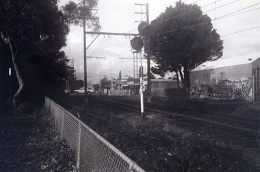
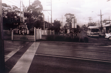 Whitehorse Historical Society Inc.
Photograph, Pedestrian Crossing & Nunawading Railway Station, 1/06/2009
One of a collection of photographs taken of the Nunawading Railway Station prior to the lowering of the railway line and building of the new railway station on the western side of Springvale Road so that the Springvale Road Rail Crossing can be eliminated.Black & white photograph of the precinct surrounding the Nunawading Station and the Springvale Road Railway crossing. This photograph is looking over the south side of the intersection in Springvale, to the pedestrian crossing and the Railway Station. The shopping centre is on the right hand side. See NP 3545 to NP3567 for the complete set of photographsnunawading railway station, springvale road nunawading, redevelopment of railway line/springvale road. -
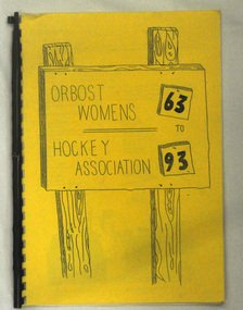 Orbost & District Historical Society
book, Orbost Women's Hockey 1963-1993
This is a local history book produced by a local sporting club.A spiral bound book of 18 pp with a yellow cover. It is titled Orbost Women's Hockey Association 63 to 93. There are hand drawings on the front cover.sport recreation hockey-women's-orbost -
 Whitehorse Historical Society Inc.
Photograph, Mitcham Railway Station
Mitcham Railway Station to be built underground during 2013.Coloured photograph of the Mitcham Railway Station. This platform is used by passengers heading south towards Ringwood, Lilydale, Belgrave etc. In 2013, the station was rebuilt underground.mitcham railway station, trains, railways -
 Whitehorse Historical Society Inc.
Photograph, Nunawading Railway Station, 1/06/2009 12:00:00 AM
One of a collection of photographs taken of the Nunawading Railway Station prior to the lowering of the railway line and building of the new railway station on the western side of Springvale Road so that the Springvale Road Rail Crossing can be eliminated.Black & white photograph of he precinct surrounding the Nunawading Station and the Springvale Road Railway crossing. This photograph is A close up of the southern entrance to the Nunawading Station from Station Street. See NP 3545 to NP3567for the complete set of photographsnunawading railway station, springvale road nunawading, station street nunawading -
 Sunbury Family History and Heritage Society Inc.
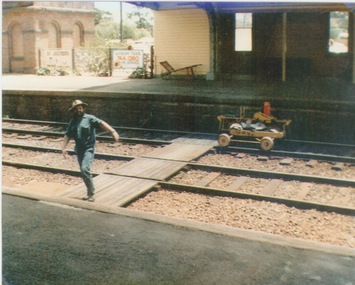
Photograph, c 1970
A railway maintenance person is crossing the railway tracks from Platform 2 to Platform 1 at Sunbury Station. There is a partial view of the historic brick water tower, which was used by the steam engines, on Platform 2.A coloured photograph of a maintenance man walking across a railway track at a station.sunbury railway station, water towers -
 Stawell Historical Society Inc
Photograph, Railway Station Stawell
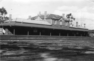
Railway Station Stawell. B/W photo showing large two storey brick station with long verandah over platform in heavy shade. Rail lines in foreground. This Photograph is a copy of a Negative owned by the Society - paid from a grant 1991. This Photograph is of Stawell Railway Station.B/W. Photograph of Stawell Railway Station taken from acroos the railway tracks. Also showing two vechiles of the far right. the centre of the building is two story stawell railways, transport, mark dadswell -
 Sunbury Family History and Heritage Society Inc.
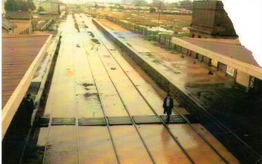
Photograph, 17th December 1985
On the afternoon of the 17th December 1985 torrential rain fell in Sunbury and surrounding areas which resulted in widespread flooding and caused disruption on the main Melbourne Bendigo Railway line. The photograph looking towards the south shows the extent of the flooding at Sunbury Station.A coloured photograph of a railway station and the flooded tracks.sunbury railway station -
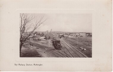 Rutherglen Historical Society
Image, The Railway Station, Rutherglen, c1900
Black and white postcard photograph of railway station, goods yard, siding and a steam train.Written on back of card: "The Railway Station Rutherglen | Dear Alice, Just a card to wish you all a Bright and Prosperous New Year. With Love From. Cousin Ellen. | Miss Barnard, 144 The Parade, Ascot Vale."railway stations, rutherglen railway station, rutherglen railway yards, steam trains