Showing 8617 items matching "south road"
-
 Whitehorse Historical Society Inc.
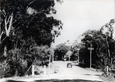
Photograph, Blackburn Road Looking South
... Blackburn Road Looking South...Black and white photo of Blackburn Road looking south.... of Blackburn Road looking south. Blackburn Road Looking South ...Used by donor in her book 'Blackburn - A Picturesque History'Black and white photo of Blackburn Road looking south.blackburn road, blackburn -
 City of Kingston
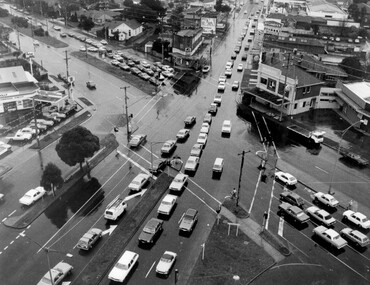
Photograph - Black and white, c. 1950
... The image shows a line of traffic travelling along South... of the intersection of Nepean Highway and South Road, taken from above... of the intersection of Nepean Highway and South Road, taken from above ...The image shows a line of traffic travelling along South Road in response to traffic light signlas while an increasing number of cars are banking up along Nepean Highway, also in response to traffic light signals.This image provides a strong contrast to images from earlier eras of the same intersection. The amount of traffic has increased enormously as well as commercial development.Black and white photograph with an aerial view of the intersection of Nepean Highway and South Road, taken from above the Moorabbin Council Chambers.Handwritten in black ink Pic [indecipherable] / 1000 Handwritten in red ink: 150%moorabbin, traffic lights, cars, nepean highway -
 Bayside Gallery - Bayside City Council Art & Heritage Collection
Photograph, Department of Crown Lands and Survey, Victoria, Brighton, Brighton East and Bentleigh, c. 1965-71
... South Road... the photograph and South Road at the bottom.... Centre Road nepean highway South Road Football Black and white ...The Department of Crown Lands and Survey (1857-1983) was responsible for the administration of survey and mapping and the sale, occupation and management of crown land throughout its existence. This aerial photograph shows parts of Brighton, Brighton East and Bentleigh and was taken circa 1965-71.brighton, department of crown lands and survey, aerial photograph, bayside, port phillip bay, map, cartographic material, bentleigh, brighton east, dendy park, dendy street, centre road, nepean highway, south road, football -
 Whitehorse Historical Society Inc.
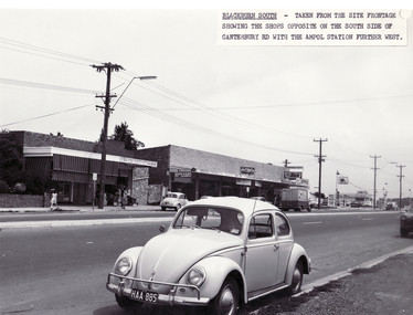
Photograph - B/W Photograph, Shops in Canterbury Road, Blackburn South, 9/11/1962 12:00:00 AM
... Shops in Canterbury Road, Blackburn South....Black and white photo of Shops in Canterbury Road..., Blackburn South. Shops in Canterbury Road, Blackburn South ...Black and white photo of Shops in Canterbury Road, Blackburn South.blackburn fibrous plaster works, shops, canterbury road -
 Bayside Gallery - Bayside City Council Art & Heritage Collection
Photograph, Department of Crown Lands and Survey, Victoria, Brighton, Brighton East and Bentleigh, c. 1965-71
... South Road... and South Road at the bottom.... highway South Road Brighton Golf Course Golf Black and white ...The Department of Crown Lands and Survey (1857-1983) was responsible for the administration of survey and mapping and the sale, occupation and management of crown land throughout its existence. This aerial photograph shows parts of Brighton and Brighton East and was taken circa 1965-71.brighton, department of crown lands and survey, aerial photograph, bayside, port phillip bay, map, cartographic material, brighton east, dendy park, dendy street, centre road, nepean highway, south road, brighton golf course, golf -
 Whitehorse Historical Society Inc.
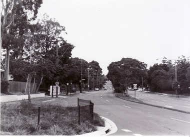
Photograph, Blackburn Road, Blackburn, 6/01/2001 12:00:00 AM
... South looking south from Canterbury Road.... Mitcham melbourne blackburn road blackburn south canterbury road ...Black and white photograph of Blackburn Road, Blackburn South looking south from Canterbury Road.blackburn road, blackburn south, canterbury road -
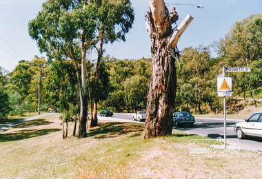 Eltham District Historical Society Inc
Photograph, Main Road, Eltham South near Antoinette Boulevard
... Main Road, Eltham South near Antoinette Boulevard...Three colour photographs of Main Road, Eltham South near... melbourne main road eltham eltham south antoinette boulevard Three ...Three colour photographs of Main Road, Eltham South near Antoinette Boulevardmain road, eltham, eltham south, antoinette boulevard -
 Eltham District Historical Society Inc
Newsclipping, 254 Fordhams Road, Eltham South, 1997 and Kieta, 290 Mount Pleasant Road, Eltham South, 1998
... 254 Fordhams Road, Eltham South, 1997 and Kieta, 290 Mount... Fordhams Road, Eltham South, 1997 and Kieta, 290 Mount Pleasant ...Contained in Volume 2 of a set of two spiral magnetic photo albums, each containing 10 leaves, 20 pages; Vol. 1 labelled "Houses - Eltham South" and Vol. 2 labelled "Eltham Houses". Newspaper clippings advertising house auctionseltham, real estate advertisement, houses, fordhams road, kieta, mount pleasant road -
 Whitehorse Historical Society Inc.
Document, Accounts - House Construction, 1953-1954
... corner of Wicking Court and Holland Road, Blackburn South..., corner of Wicking Court and Holland Road, Blackburn South 1953... Blackburn South Holland Road Blackburn South Copy of Accounts ...Copy of Accounts for construction of Walter Wicking's house,Copy of Accounts for construction of Walter Wicking's house, corner of Wicking Court and Holland Road, Blackburn South 1953 - 1954.Copy of Accounts for construction of Walter Wicking's house,houses, wicking, walter, wicking court, blackburn south, holland road, blackburn south -
Whitehorse Historical Society Inc.
Document, Warrawong Estate, 27/10/1962 12:00:00 AM
... corner Eley and Middleborough Roads, Blackburn South on 27... Eley and Middleborough Roads, Blackburn South on 27 Oct 1962.... South on 27 Oct 1962. Warrawong Estate Middleborough Road ...29 Home Sites to be auctioned by Frank Fisher & Co.,29 Home Sites to be auctioned by Frank Fisher & Co., corner Eley and Middleborough Roads, Blackburn South on 27 Oct 1962.29 Home Sites to be auctioned by Frank Fisher & Co.,warrawong estate, middleborough road, blackburn south, eley road, blackburn south, frank fisher co. -
 City of Kingston
Pamphlet - Colour, S. M. Reynolds, Estate Agent, Moorabbin Shire Hall Estate Second Section, c. 1930
... by South Road and Highbury Street, including Prince Street... bordered by South Road and Highbury Street, including Prince Street... by South Road and Highbury Street, including Prince Street ...Sales plan for land in the suburb of Moorabbin, bounded by South Road and Highbury Street, including Prince Street, Charming Street, Thomas Avenue and Keith Road.The developing urban area of Moorabbin within the City of Kingston. This land sale pamphlet illustrates the subdivision of land within the municipality and the changing demographic of the district as new houses are constructed close to infrastructure.Colour pamphlet advertising for private sale the Moorabbin Shire Hall Estate, Moorabbin. Incorporates a map of the estate bordered by South Road and Highbury Street, including Prince Street, Charming Street, Keith Road and Thomas Avenue.Handwritten in grey pencil on subdivision map below subdivision 63: £4 Handwritten in grey pencil on subdivision map below subdivision 66: 4 Handwritten in grey pencil on subdivision map below subdivision 80: 3. Handwritten in grey pencil on subdivision map below subdivision 81: 4 Handwritten in grey pencil on subdivision map below subdivision 83: 2 Handwritten in grey pencil on subdivision map below subdivision 96: £3 Handwritten in grey pencil on subdivision map below subdivision 97: 3 Handwritten in grey pencil on subdivision map to the left of subdivision 102: 3 Handwritten in grey pencil on subdivision map on the corner of Thomas Avenue and Highbury Street: vertical line next to a square with a cross in it.land sales, estate, moorabbin -
 Eltham District Historical Society Inc
Photograph, View in Eltham looking south along Main road from Bridge Street, 1902
... View in Eltham looking south along Main road from Bridge...Looking south along Main Road from the south side... melbourne Looking south along Main Road from the south side ...Looking south along Main Road from the south side of the intersection of Bridge Street with Main Road. Post Office (Anne Hunniford Postmistress) on left then the Commercial Bank of Australasia building. The house on the right, 'Derril,' was purchased by Walter Gahan in 1924 and was demolished in 1968 when Main Road was widened. In the distance on the left is Watson's Hotel and on the right (opposite side of the main road, Morris's Hotel Cross Ref: 0624This photo forms part of a collection of photographs gathered by the Shire of Eltham for their centenary project book,"Pioneers and Painters: 100 years of the Shire of Eltham" by Alan Marshall (1971). The collection of over 500 images is held in partnership between Eltham District Historical Society and Yarra Plenty Regional Library (Eltham Library) and is now formally known as the 'The Shire of Eltham Pioneers Photograph Collection.' It is significant in being the first community sourced collection representing the places and people of the Shire's first one hundred years.Digital image Print 14 x 24 cm 35 mm B&W negativeanne jane hunniford (1855-1928), bridge street, commercial bank of australia, derril, eltham, gahan house, main road, morris's hotel, post office, shire of eltham pioneers photograph collection, watsons hotel -
Whitehorse Historical Society Inc.
Document, Aberdeen Road Blackburn South, 2001
... Aberdeen Road Blackburn South...Auction of 29 Aberdeen Road Blackburn South Saturday 7 July... Road Blackburn South No.29 Auction of 29 Aberdeen Road ...Auction of 29 Aberdeen Road Blackburn South Saturday 7 July 2001.Auction of 29 Aberdeen Road Blackburn South Saturday 7 July 2001. Sold 6 July $252,000. Agent: WoodardsAuction of 29 Aberdeen Road Blackburn South Saturday 7 July 2001. aberdeen road, blackburn south, no.29 -
 Bayside Gallery - Bayside City Council Art & Heritage Collection
Photograph, Department of Crown Lands and Survey, Victoria, Melbourne Project: Brighton, Hampton, Sandringham, 1976
... South Road... South Road at the top, Beach Road on the left, Hampton Street... Club South Road Beach Road Hampton Street Melbourne Project ...The Department of Crown Lands and Survey (1857-1983) was responsible for the administration of survey and mapping and the sale, occupation and management of crown land throughout its existence. This aerial photograph shows parts of Brighton, Hampton and Sandringham and was taken on 1 December 1976brighton, department of crown lands and survey, aerial photograph, bayside, port phillip bay, map, cartographic material, hampton, sandringham, green point, sandringham yacht club, south road, beach road, hampton street, melbourne project 1976 -
 Bayside Gallery - Bayside City Council Art & Heritage Collection
Photograph, Department of Crown Lands and Survey, Victoria, Melbourne Project: Brighton and Hampton, 1976
... South Road.... The main roads shown include South Road at the top, The Esplanade... Hampton Green Point Brighton Beach South Road The Esplanade ...The Department of Crown Lands and Survey (1857-1983) was responsible for the administration of survey and mapping and the sale, occupation and management of crown land throughout its existence. This aerial photograph shows parts of Brighton and Hampton and was taken on 1 December 1976. brighton, department of crown lands and survey, aerial photograph, bayside, port phillip bay, map, cartographic material, melbourne project 1976, brighton yacht club, middle brighton baths, hampton, green point, brighton beach, south road, the esplanade, hampton street -
Glen Eira Historical Society
Article - St Mary The Virgin, Kooyong Road, South Caulfield
... St Mary The Virgin, Kooyong Road, South Caulfield...Kooyong Road, Caulfield South, Victoria, Australia... The Virgin, Kooyong Road, South Caulfield ...Brief history of the Kooyong Road Church; taken from A Coming Together by Gwenda Mann and Gordon Gray, (a short account of some of the highlights of the first Fifty years of the Kooyong Road Methodist Church, Caulfield, Victoria), date unknown and photocopied. The article details the commencement of the Methodist churches circuit. Includes some history of the churches, early parishioners, the Trust Organ Fund, the removal from the Elsternwick to the new Caulfield circuit. The silver Jubilee celebrations. Article by Iris Kenatick being a local preacher in the circuit, and list of Pastors and Ministers from 1917 – 1989.kooyong road church, ontario street, catterall j. m rev., caulfield south, caulfield methodist circuit, elsternwick, hawthorn road, bambra road, eddy j. h., mclelcan mr., bundeera road, clarence street, hunt w. h., foy and gibson, balaclava, north road, penny e. r., field a. b, sunday schools, eddy mrs., field mrs., hunt mrs., leach a. g, leach mrs, levens miss, levens mr., spargo mr, spargo mrs, taylor mrs, watson mrs., festivals and celebrations, clemens v. miss, sprunt miss, bishop miss, king miss (2), cox mr, choirs, church furniture, venus street, watson amy, dodds p., oliver f. mrs, campbell h., truscott a, truscott mrs., mcgregor f. mrs, jupiter street, organs, halls, hawthorn road church, tennis courts, foundation stones, kindergartens, cricket clubs, blake e. b rev, mcgregor f. r., price c, pearson a, mahaffy j. b, hollyock e, blake mrs, aveling mrs, cripps mrs, veitch mrs, sharp w, sprunt b, hillier h. r., hillier mrs, (cousins) dulcie, cousins rowley, st mary the virgin, watson(lund) amy, millar joan, kenafick iris, governors, huntingfield lord, festivals and celebrations, clergy, church services, church festivals -
Glen Eira Historical Society
Letter - St Mary The Virgin, Kooyong Road, South Caulfield
... St Mary The Virgin, Kooyong Road, South Caulfield...Kooyong Road, Caulfield South, Victoria, Australia... Jupiter Street Hawthorn Road Caulfield South York Street St Mary ...Handwritten correspondence to John Wells, from C Loftis, secretary to Kooyong Road, Church regarding History of City of Caulfield, in particular, mention of the three churches in the new Caulfield circuit.caulfield, wells c john, loftis c., hunkin e. mr. rev., kooyong road, manse, bundeera road, jupiter street, hawthorn road, caulfield south, york street, st mary the virgin -
 Glen Eira Historical Society
Photograph - St Mary The Virgin, Kooyong Road, South Caulfield
... St Mary The Virgin, Kooyong Road, South Caulfield...Kooyong Road, Caulfield South, Victoria, Australia..., Kooyong Road, South Caulfield ...Three coloured photographs taken November 2009, includes front facade, Foundation Stone and Anglican Catholic Church signage details.the anglican catholic church, methodist church, st mary the virgin, kooyong road., mitchell graeme a., francis f. h, foundation stones. -
Glen Eira Historical Society
Document - St Mary The Virgin, Kooyong Road, South Caulfield
... St Mary The Virgin, Kooyong Road, South Caulfield...Kooyong Road, Caulfield South, Victoria, Australia... Kooyong Road Caulfield South Mitchell A. Graeme Document St Mary ...Handwritten document on Parish of St Mary the Virgin noting that the church has been situated at a number of venues. The present address has been used by St Mary's for twelve years; and the Father is Graeme A. Mitchellst mary the virgin, kooyong road, caulfield south, mitchell a. graeme -
Glen Eira Historical Society
Article - St Mary The Virgin, Kooyong Road, South Caulfield
... St Mary The Virgin, Kooyong Road, South Caulfield...Kooyong Road, Caulfield South, Victoria, Australia... Rowley Kooyond Road Kooyong Road Church Lund Amy South Caulfield ...Four articles by Dulcie Cousins, Joan Millar, Jim Millar and Grace Hocking. They each give a brief insight in what they enjoyed about being a member of the Kooyong Road Church. From the social and sports clubs, anniversary occasions, picnics in the Dandenongs, church on Sunday nights, the passing parade of ministers and the general church community they embraced.bundeera road uniting church, cousins dulcie, cousins rowley, kooyond road, kooyong road church, lund amy, south caulfield uniting church, truscott. mr, millar joan, kennedy duncan rev., cousins beth, millar jim, gray helen, cousins john, hocking grace, gray christie, st mary the virgin -
Glen Eira Historical Society
Document - St Mary The Virgin, Kooyong Road, South Caulfield
... St Mary The Virgin, Kooyong Road, South Caulfield...Kooyong Road, Caulfield South, Victoria, Australia... Road, South Caulfield ...Parish of St Mary the Virgin, Flyer, calendar of church services and meeting from 24/02/1998 to 22/03/1998.st mary the virgin -
Glen Eira Historical Society
Magazine - St Mary The Virgin, Kooyong Road, South Caulfield
... St Mary The Virgin, Kooyong Road, South Caulfield...Kooyong Road, Caulfield South, Victoria, Australia... Mary The Virgin, Kooyong Road, South Caulfield ...Anglican Catholic Church of Australia, November 2009. The journal includes an article in which they mention the two small reliqies that the church owns. Includes a photo with Fr. Graeme Mitchellst mary the virgin, kooyong road., jupiter street, caulfield south, mitchell graeme fr. -
 Kew Historical Society Inc
Photograph - South Esk - Cotham Road (Kew), Ron Setford, 1967
... South Esk - Cotham Road (Kew)..." Photograph South Esk - Cotham Road (Kew) Ron Setford ...Ron Setford and his wife Grace Setford lived in Tanner Avenue, East Kew, from c.1946 to c.1995. A keen photographer, he recorded the changing face of Kew over a 20 year period. Apart from 30 photographs of built structures and places in Kew dating from 1960 and 1961, 145 of his 35mm colour slides chronicle the development of the Eastern Freeway through the Yarra Valley over a five year period from c.1972 to c.1977. This important collection was donated to the Society by his granddaughter in 2025.This collection of 175 35mm slides is of local and statewide significance, owing to its subject matter, particularly the major development of road transport infrastructure during the 1970s with the construction of the Eastern Freeway. The photographer also took care to annotate and date most of his slides which enable the researcher to pinpoint temporal and spatial locations."South Esk / May 1967"ron setford, south esk - kew (vic.), historic houses -- kew (vic.) -
 Whitehorse Historical Society Inc.
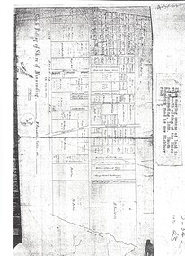
Map, Shire of Nunawading 1888
... south boundary road... of the Shire of Nunawading, 1888. South Boundary Road is now Highbury... forest hill holland road blackburn south burwood highway Plan ...Plan showing owners of land in the South Riding of the Shire of Nunawading, 1888. South Boundary Road is now Highbury Road.shire of nunawading. south riding, south boundary road, burwood east, highbury road, springvale road, mahoneys road, forest hill, holland road, blackburn south, burwood highway -
 City of Kingston
Pamphlet - Colour, Arthur Tuckett & Son, Auctioneers and Subdivisional Specialists, Auction of Station Estate, Moorabbin, 1923
... by Railway Crescent, South Road, Jasper Road and Pattersons Road.... Road, South Road and Railway Crescent. ... by Railway Crescent, South Road, Jasper Road and Pattersons Road ...Sales plan for land in the suburb of Moorabbin, bounded by Railway Crescent, South Road, Jasper Road and Pattersons Road.The developing urban area of Moorabbin within the City of Kingston. This land sale pamphlet illustrates the subdivision of land within the municipality and the changing demographic of the district as new houses are constructed.Colour pamphlet advertising an auction of the Station Estate Moorabbin. Incorporates details of the shopping facilities, proximity to the railway line, variety of schools and churches in the area, and a sales plan for home sites and shop fronts. Incorporates a map of the estate bordered by Pattersons Road, Japer Road, South Road and Railway Crescent. Handwritten in grey pencil top right front page: Station Estate / late [indecipherable] Handwritten in red pencil on subdivision map: x [on majority of properties marked on the map] Handwritten in grey pencil on subdivision map: additional subdivisions drawn in and large lines drawn across the mapmoorabbin, land sales, estate -
 City of Kingston
Pamphlet - Colour, Brock Bros, South Brighton Township Estate, 1888
... (Moorabbin), bounded by Point Nepean Road, South Road, Patterson... of the estate bordered by Point Nepean Road, South Road, Patterson... (Moorabbin), bounded by Point Nepean Road, South Road, Patterson ...Sales plan for land in the suburb of South Brighton (Moorabbin), bounded by Point Nepean Road, South Road, Patterson Street and the Mordialloc Railway Line. Incorporates Wolsely Street and Gordon StreetThe developing urban area of Moorabbin within the City of Kingston. This land sale pamphlet illustrates the subdivision of land within the municipality and the changing demographic of the district as new houses are constructed close to infrastructure.Colour pamphlet advertising for private sale the South Brighton Township Estate, South Brighton. Incorporates a map of the estate bordered by Point Nepean Road, South Road, Patterson Street, and the Mordialloc Railway Line. Includes Wolsley Street and Gordon Street. land sales, south brighton, estate, moorabbin -
Whitehorse Historical Society Inc.
Document, Holland Road, Blackburn South, 1/02/2000
... Holland Road, Blackburn South... Holland Road, Blackburn South for auction 26 February 2000... Mitcham melbourne Holland Road Blackburn South No 2/36 Auctions ...Auction brochure for 3 bedroom brick villa unit at 2/36 Holland Road, Blackburn South for auction 26 February 2000. Agents: Whitehorse Partners First National.holland road, blackburn south, no 2/36, auctions -
 Whitehorse Historical Society Inc.
Pamphlet, 739 - 743 Highbury Road, Vermont South, 1/11/1998
... 739 - 743 Highbury Road, Vermont South... house on 1.67 acres, 739-743 Highbury Road, Vermont South... Mitcham melbourne highbury road vermont south nos 739-743 ...Fletcher & Parker real estate pamphlet, p. 13: 4 Bedroom house on 1.67 acres, 739-743 Highbury Road, Vermont South, for auction 21 November 1998.highbury road, vermont south, nos 739-743., fletcher and parker, auctions -
 Eltham District Historical Society Inc
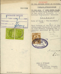
Document - Grant of Probate, Supreme Court of Victoria et al, In the Will of John Henry Clark, Main Road, Eltham South, 5 Apr 1957
... In the Will of John Henry Clark, Main Road, Eltham South... and bootmaker of Main Road, Eltham South granted to John Francis... and bootmaker of Main Road, Eltham South granted to John Francis ...Probate of the Will of John Henry Clark, photographer and bootmaker of Main Road, Eltham South granted to John Francis Carrucan of Dalton Street, Eltham, the Executor of the Will.bootmakers, j.h. clark photo, john francis carrucan, john henry clark, photographer, probate, prov, will -
 Sunshine and District Historical Society Incorporated
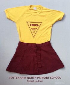
Sports Uniform (Netball) - TOTTENHAM NORTH PRIMARY SCHOOL, 'Ryder' Brand T-Shirt, Early to mid 1980's
... south road braybrook... and was built on a South Road, Braybrook site purchased in 1929. After... was opened on 29 May 1953 and was built on a South Road, Braybrook ...This Netball uniform from circa 1986 was worn by a girl named Rebecca when she attended the Tottenham North Primary School. Tottenham North Primary School was opened on 29 May 1953 and was built on a South Road, Braybrook site purchased in 1929. After a fire in February 1961 the pupils were sent to the Powell and Curtin Street schools in Yarraville, and to the Maidstone and Sunshine East schools. The new building was officially opened on 22 August 1962 by A. McDonell, Director of Education, and it had sixteen classrooms, an art/craft room, and an assembly hall. Sporting achievements by the pupils included the 1963 football premiership and the 1968 cricket premiership. Over the years it has been called Tottenham Primary, Tottenham Crossing Primary, and Maidstone Primary. The different names resulted because of mergers with other local primary schools as the number of primary aged children in the Braybrook and Tottenham area changed. The school on South Road is now named Dinjerra Primary School. Dinjerra supposedly means 'out west' in the dialect of the original indigenous people of the area. Dinjerra Primary School is now the only neighbourhood government primary school in Braybrook Tottenham. The above information was sourced and compiled from: 1. 'Vision and Realisation - A Centenary History of State Education in Victoria - Volume 3', Education Department of Victoria 1973. 2. The Dinjerra Principal's website article at: http://www.dinjerra.vic.edu.au/91/Message-from-the-Principal.The netball uniform serves as a historic reminder that a school named Tottenham North Primary School once existed. The uniform also provides us with information of the colours used on these types of sports uniforms, and of the design of the School Logo.Two items of Netball Uniform. (a) Skirt - Maroon coloured wrap around sports skirt. (b) T-shirt - Yellow, Size 14 'Ryder' brand children's T-shirt, with maroon coloured triangular shaped School Logo printed on the front.TNPS. TOTTENHAM NORTH P.S. 4703 - (Printed inside triangle)sports uniform, netball skirt, netball t-shirt, tottenham north primary school, south road braybrook, tottenham primary school, maidstone primary school, tottenham crossing school, dinjerra primary school, tottenham north state school, state school 4703