Showing 198 items
matching township and bridges
-
 Buninyong & District Historical Society
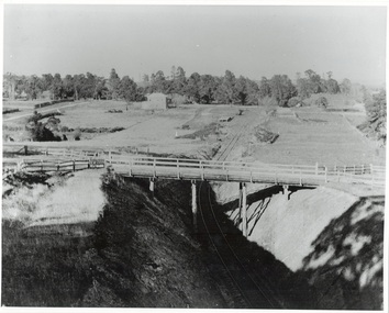
Photograph - Photo of Original Photograph, W. Jack, Buninyong Railway Station precinct in 1940, 9 June 1940
Railway station and surrounds in 1940.B/W photograph f Buninyong Railway station precinct, taken 9 June 1940, showing Barkly St. trestle bridge over railway cutting, Butter Factory on left, station and rail yards on left, township to thye right.buninyong, railway, bunny, butter factory, bridge, cutting, barkly st. -
 Bendigo Historical Society Inc.
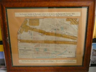
Document - PLAN OF TOWNSHIP OF SANDHURST 1854, July 25. 1854
Coloured- The planned township of Sandhurst is placed over the early Bendigo creek township of 1854. The two main streets of the early township were Camp and Auction streets. The street shown as Dowling street later became Queen & Hopetoun streets. The building near the bridge at View Point is Pykes Building. The Post Office was located here in 1854 - 58. Bernal street is now Chapel street. The creeks were straightened to their present courses. Streets on map are. Pall Mall - Bridge - McCrae - Hargraves - Lyttleton - Myers - Mollison - McLaren - Mitchell - Williamson - Mundy - Bernal - Baxter - Larritt - Bramble - McIvor - Bull. Also shown on map: Bendigo Creek - Government Reserve - Present Cemetery - Proposed diversion of creek. FH 562 Deframed 2022Lithographed at Surveyor Generals Office. Melbourne. July 25. 1854. By R. Meikle.place, bendigo, original 1854 bendigo map -
 Lakes Entrance Historical Society
Postcard - Bullock Island, 1920c
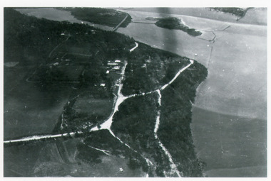
... Bridges ...1 x Faded miniature postcard 6.5 x 8.5|1 x Black and white 9.5 x 12 copied from album in private hands|1 x Sepia toned 10 x 15|1 x Black and white 12 x 17.5Black and white small format postcard of Bullock Island. It shows the approaches to the concrete North Arm Bridge over North Arm, the footbridge to Bullock Island, the entrance to the Gippsland Lakes from Bass Strait and part of the township on the hummocks. Lakes Entrance VictoriaLakes Entrancewaterways, topography, islands, bridges -
 Lakes Entrance Historical Society
Postcard - Township, 1998c
Tinted small format postcard showing the township situated on the isthmus between two stretches of water the Cunninghame Arm and the North Arm. Work in progress widening the North Arm Bridge as seen by workmen's huts beside the southern approach. Lakes Entrance Victoriajetties, waterways, topography, township -
 Ringwood and District Historical Society
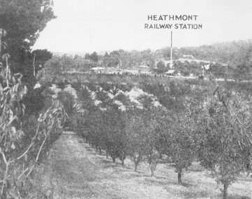
Photograph, View of what was Heathmont township taken from about Royal Avenue looking at Mr. Herman Pump's orchard. Old bridge over Canterbury Road can be seen on left
Typed below photograph, "View of what was Heathmont township taken from about Royal Avenue looking at Mr. Herman Pump's orchard. Old bridge over Canterbury Road can be seen on left." -
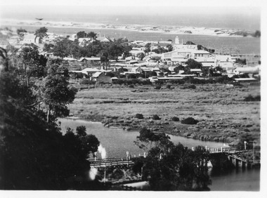
 Lakes Entrance Historical Society
Postcard - Township, 1930c
... Bridges ...Black and white small format postcard showing the township situated on the land between the Cunninghame Arm and North Arm. Lakes Entrance VictoriaLakes Entrance from Princes Highway (on back)bridges, township, topography, waterways -
 Lakes Entrance Historical Society
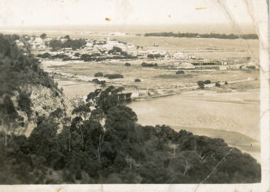
Photograph - Kalimna, Bulmer H D, 1940c
... Bridges ...Black and white photograph of aerial view of Kalimna escarpment, Princes Highway, road to Kalimna Hotel, scattering of buildings including Gainsborough House, in distance is North Arm bridge, footbridge to undeveloped Bullock Island with rock groynes in place. Part of eastern pier of entrance at Lakes Entrance, Victoria. waterways, topography, township, bridges -
 Lakes Entrance Historical Society
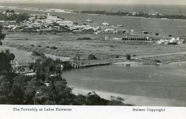
Postcard - Lakes Entrance, Bulmer H D, 1935
... Bridges ...Marine Parade has not yet been formed through the low lying marshy area adjacent to North Arm. Very little vegetation on Eastern end of hummocks.Black and white postcard of the western end of Lakes Entrance,showing a glimpse of the North Arm bridge, town situated adjacent to Cunninghame Arm, sand hummocks and ocean in distance. Lakes Entrance VictoriaThe Township at Lakes Entrancetownship, waterways, bridges, hotels -
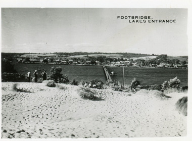
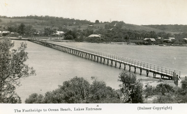 Lakes Entrance Historical Society
Postcard - Footbridge, 1937c
... Bridges ...Copies as follows|One Miniture postcard tinted 6.5 x 9|One Black and white copy 6.5 x 11|One Tinted copy 20 x 28|One Postcard 17 x 12Black and white postcard showing waterfront, some buildings along esplanade, no buildings on Myer St Hill. Footbridge across Cunninghame Arm completed to high tide mark, ramp constructed later, scrub in foreground. Lakes Entrance VictoriaThe Footbridge to Ocean Beach Lakes Entrancevegetation, bridges, waterways, township -
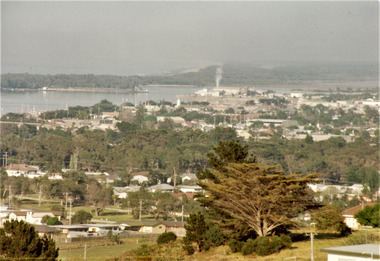 Lakes Entrance Historical Society
Photograph - Township, Fish Marie, 1985c
... Bridges ...Colour photograph of township, showing building on Bullock Island, Cunningham Arm and small white shed on old New Works Jetty near the entrance, view towards the barrier. Photo taken from near telecom tower on Merrangbaur Hill 1985c. Lakes Entrance Victoriatopography, township, waterways, bridges -
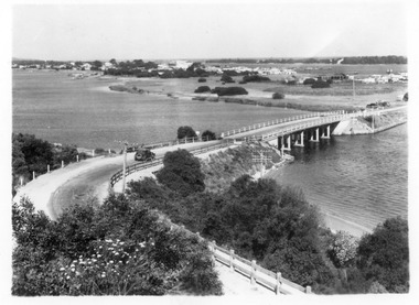
 Lakes Entrance Historical Society
Postcard - Township, 1950c
... Bridges ...2 copies 6 x 9Black and white small format postcard of footbridge over Cunninghame Arm. It shows people on bare sand dunes in foreground boat moored beside bridge, motor vehicles parked along retaining wall on North shore with town buildings in background. Lakes Entrance VictoriaFootbridge Lakes Entrancebridges, waterways, township, people -
 Lakes Entrance Historical Society
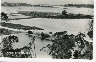
Photograph - North Arm bridge Lakes Entrance Victoria, 1935c
... Bridges ...Black and white photograph of view of concrete North Arm Bridge, showing highway to town, Cunninghame Arm, sand hummocks, vegetation, touring car approaching bridge, and three cars parked at town end of bridge, electricity and telegraph poles. Lakes Entrance Victoriatownship, vegetation, transport, bridges -
 Lakes Entrance Historical Society
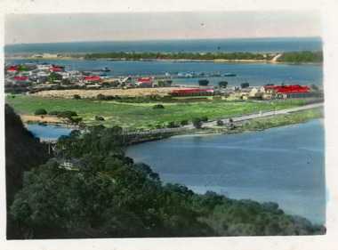
Postcard - North Arm bridge Lakes Entrance Victoria c1930, 1930c
... Bridges ...Black and white small format postcard showing the town, North Arm bridge, Cunninghame Arm, sand hummocks, taken from Mt Barkly / Jemmys Point. Lakes Entrance Victoriabridges, township, coast, waterways -
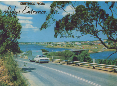 Lakes Entrance Historical Society
Postcard - Views of Lakes Entrance c1972, 1972 c
... Bridges ...Princes Highway looking down to North Arm bridge with town in distance, people camped on North Arm foreshore and car towing caravan in foreground Lakes Entrance VictoriaColour postcard taken from Princes Highway looking down to North Arm bridge with town in distance, people camped on North Arm foreshore and car towing caravan in foreground Lakes Entrance VictoriaGreetings from Lakes Entrancebridges, roads and streets, township, vehicles -
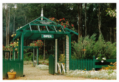 Marysville & District Historical Society
Photograph (Item) - Colour photograph, 1992
A colour photograph of the garden entrance and bridge at Arbor Green Gardens in Marysville. This cottage, along with most of the buildings in the township, was destroyed in the 2009 Black Saturday bushfires.A colour photograph of the garden entrance and bridge at Arbor Green Gardens in Marysville.Garden Entrance & bridge./ Arbor Green Galleries/ 1 Falls Rd. M'sville./ Spring 1992marysville, victoria, australia, photograph, accommodation, arbor green cottage, 2009 black saturday bushfires -
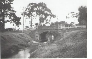 Sunbury Family History and Heritage Society Inc.
Photograph, Rosa McCall, Moonee Ponds Creek, 1949
... Bridges ...The single arched stone bridge spans the Moonee Ponds Creek in the former Old Broadmeadows Township, now Westmeadows. The historic bridge is in Fawkner Street, and has a heritage classification. The Moonee Ponds Creek flows from the upper reaches of Greenvale and flows into the Yarra at Docklands.The stone bridge over the Moonee Ponds Creek was erected in 1869 and replaced a less substantial one.A black and white print of a non-digital photograph of a stone single-span bridge spanning a creek. White post-and-rail fence has been constructed ion either side of the bridge. Pine trees are growing on then creek banks.moonee ponds creek, old broadmeadows township, bridges, fawkner street, westmeadows -
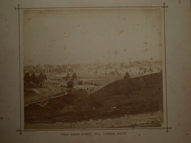 Clunes Museum
Photograph, BEAUCHAMP PHOTOGRAPHY, FROM ANGUS STREET HILL, LOOKING SOUTH, 1879
PHOTOGRAPH OF TOWNSHIP OF CLUNES ABOUT 1875. LOOKING SOUTH. WOODEN BRIDGE IN FOREGROUND, 1 SEPIA PHOTOGRAPH MOUNTED ON CARDBOARD .2 SEPIA PHOTOGRAPH MOUNTED EDGES REMOVED .3 BLACK AND WHITE PHOTO PRINT .4 BLACK AND WHITE PHOTO PRINT .5 PHOTOCOPY OF PHOTOGRAPHFROM ANGUS STREET HILL LOOKING SOUTHphotographs, clunes township and mining and footy oval -
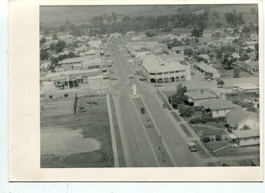 Orbost & District Historical Society
black and white photographs, C 1960s - 1970s
3290.1 is an aerial photograph of the township of Orbost looking south along Nicholson Street. The tennis courts and recreation reserve are on the left. The War Memorial, Commonwealth Hotel at the Saisbury Street intersection is in the centre of the photograph. 3290.2 is an aerial view of the Orbost township looking north, showing the bridge across the Snowy River in the foreground,These photographs are detailed pictorial records of the Orbost township C 1960s - 1970s.Two photographs which are aerial views of a township showing streets, buildings and vehicles. 3290.1 is a black / white photograph. 3290.2 is a coloured photograph.orbost-township-c1960s-1970s aerial-photograph-orbost -
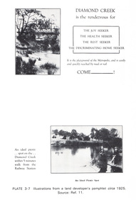 Eltham District Historical Society Inc
Work on paper (Sub-Item) - Photograph, Illustrations from a land developer's pamphlet promoting Diamond Creek, circa 1925
Photos illustrating the Diamond Creek with a bridge over it and two people sitting by the creek, one is fishing with text describing the kind of person who may like to come to the township. diamond creek, advertising, promotion, land development, real estate -
 Orbost & District Historical Society
black and white photographs, February 17 1971
After the damage from the February 1971 floods at Orbost when the abutment to the Snowy River road bridge was washed away a Bailey bridge, portable, pre-fabricated, truss bridge, was put into place to ensure town access, the C.R.B. rebuilt the approach to the bridge driving new piles and constructing the Bailey bridge. They worked late into the night under flood lights to ensure the link from the Orbost township to the Princes Freeway would be open to traffic as soon as possible.These photographs are pictorial records of a significant event in the history of Orbost.Three black / white photographs of a Bailey bridge being erected across a river. 3245.1 and 3245.2 are the same. bailey-bridge orbost-snowy-river-bridge bridge-orbost -
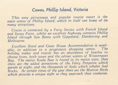 Phillip Island and District Historical Society Inc.
Photograph Folder, approx 1940's - 1950's
Coloured Souvenir folder of 12 postcards donated by M Arnell.Souvenir Colour Folder of 12 colour postcards of Cowes and Phillip Island. Photographs Include: Cowes Beach, Cowes Pier, Koalas, Cowes Township, The Nobbies, Summerland Surf Beach, Suspension Bridge, Thompson Avenue, Cowes, Penguin Parade, Seal Rocks, The Isle of Wight Hotel and The Blowhole.Front cover: A Souvenir of Picturesque Cowes. A Special selection of Scene in Full Colour.phillip island, cowes phillip isand, the isle of wight hotel cowes phillip island, the blowhole phillip island, penguins, koalas, seals, m arnell -
 Orbost & District Historical Society
black and white photographs, 25.11.1976
These photographs were taken on November 25, 1976 at the official opening of the current Snowy River road bridge. Included in the photographs are: John Duggan; Pat Hall, C.R.B. chairman, R.E.V. Donaldson (3240.7) and J.A.Rafferty, the state minister for Transport, who cut the ribbon (3240.8). Di Young and Cheryl Dusting (3240.9) distributed souvenir information pamphlets to official guests. The Snowy River road bridge is one of four built as part of the 8.4 km project spanning the Orbost flood plains. The Snowy River bridge and another over the nearby Ashbys Gulch are among the 10 longest bridges in Victoria, being the eighth and fifth longest respectively. The new bridge removed through traffic from Orbost township crossing the Snowy River 45 m downstream of the old bridge.This bridge is the fourth to provide a crossing to the township of Orbost. (info from CRB NEWS No. 34. DECEMBER, 1976) These photographs are pictorial records of a significant event in Orbost's history.Eleven black / white photographs all related to the official opening of the current Snowy River Bridge. Details are in catalogue folder.snowy-river-bridge -
 Eltham District Historical Society Inc
Photograph, View at Warrandyte, Vic, c.1937
View looking southeast across the bridge to Warrandyte township. Taken from the northern side of the Yarra River from near present day 244 Research-Warrandyte Rd, North WarrandyteThis photo forms part of a collection of photographs gathered by the Shire of Eltham for their centenary project book,"Pioneers and Painters: 100 years of the Shire of Eltham" by Alan Marshall (1971). The collection of over 500 images is held in partnership between Eltham District Historical Society and Yarra Plenty Regional Library (Eltham Library) and is now formally known as the 'The Shire of Eltham Pioneers Photograph Collection.' It is significant in being the first community sourced collection representing the places and people of the Shire's first one hundred years.Digital image 4 x 5 inch B&W Negshire of eltham pioneers photograph collection, warrandyte, north warrandyte, warrandyte bridge -
 Lake Bolac & District Historical Society
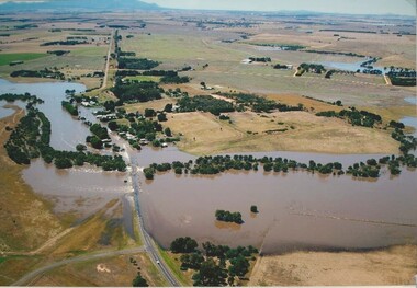
Colour photograph, Wickliffe Flood, Jan .2011
Wickliffe, the flooded Hopkins River flowing from left to right, both under and over the bridge, showing the inundated Glenelg Highway and township. January, 2011. Photograph courtesy James Davidson.wickliffe, hopkins river, flood, glenelg highway -
 Sunbury Family History and Heritage Society Inc.
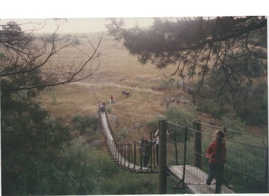
Photograph, Catanery Bridge, Bulla, c1980s
... bridges ...The narrow swing catanery bridge was built behind the school across the Deep Creek downstream from the bluestone Bulla Bridge. It was built so that children who lived on the south side of Bulla Township could access the school more easily and in shorter time than if they had to go by the main roads.The bridge was constructed in the days when most children walked to school. The use of this bridge cut the children's travel time and distance to school quite considerably and was used for many years until the school was closed in 1996.A coloured photograph of the children on a narrow swing bridge and the path they used to approach the bridge over open ground. bulla primary school, swing bridge, bridges, catanery bridge -
 Orbost & District Historical Society
black and white photograph, first half 20th century
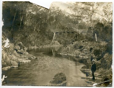
This appears to be the Boggy Creek bridge and to have been taken at Nowa Nowa. The Boggy Creek Bridge was built in 1916 as part of the Bairnsdale to Orbost extension to the main Gippsland Railway, and is situated in the middle of the township of Nowa Nowa, crossing a steep-sided and well-timbered creek-valley. This section of the line closed in 1987.This bridge plays a major part in the identity and history of the town of Nowa Nowa, since Boggy Creek’s steep sided valley divides the township into two components. It is part of the East Gippsland Railway line.A black / white photograph of a bridge across a creek. A young man in a suit is standing in the foreground.boggy-creek-bridge-nowa-nowa -
 Orbost & District Historical Society
black and white photograph, first half 20th century
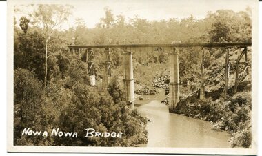
This appears to be the Boggy Creek bridge and to have been taken at Nowa Nowa. The Boggy Creek Bridge was built in 1916 as part of the Bairnsdale to Orbost extension to the main Gippsland Railway, and is situated in the middle of the township of Nowa Nowa, crossing a steep-sided and well-timbered creek-valley. This section of the line closed in 1987.This bridge plays a major part in the identity and history of the town of Nowa Nowa, since Boggy Creek’s steep sided valley divides the township into two components. It is part of the East Gippsland Railway line.A black / white photograph / postcard of a tall railway bridge, with concrete pylons in the centre,There is a creek below.on front - bottom left - " NOWA NOWA BRIDGE"boggy-creek-railway-bridge nowa-nowa railway-bridge east-gippsland-railway orbost-bairnsdale-railway -
 Eltham District Historical Society Inc
Work on paper (Sub-Item) - Aerial Photograph, Diamond Creek from Yarra River to Wattletree Road, Eltham
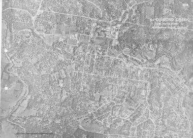
Black and white aerial photograph witrh key features around the central place of Eltham township marked inluding Yarra River, Main Road, Bridge Street and Ryans Road, Eltham North land development, real estate, aerial view, eltham, eltham north -
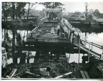
 Orbost & District Historical Society
black and white photographs, 1975
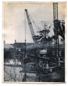
These are photographs of the construction of the current cement road bridge across the Snowy River at Orbost. Construction of the bridges commenced in January 1975, with an expectation to open the bridge across the Snowy River as soon as possible. Less than two years later, on 25 November 1976, the bridge across the Snowy River was opened to traffic, allowing the old bridge to be demolished. The remainder of the Orbost Bypass, both the floodplain crossings and the eastern section around the township itself, was declared ‘Princes Freeway’ and opened to traffic in December 1977. (ref http://mrv.ozroads.com.au)The opening of this Snowy River Bridge was an important development in the accessibility to the township of Orbost. These photographs record its construction.Two black / white photographs showing the construction of a road bridge across a river. 3257.1 shows piles being dropped beside the bridge, 3257.2 is of the early stages of construction of this bridge.snowy-river-bridge-orbost road-construction-orbost bridge-orbost -
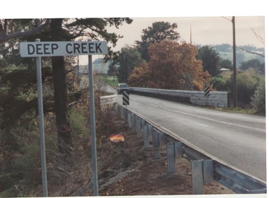 Sunbury Family History and Heritage Society Inc.
Photograph, Bulla, C 1980s
The photograph shows the approach to the Bulla Bridge at Deep Creek in the Township of Bulla. Immediately on crossing the bridge there is a sharp bend in the road and a step ascent up Bulla Hill through the cutting until level ground is reached. The photograph is looking to the NW. Deep Creek meets the Maribyrong River further downstream and closer to Keilor.The bridge and road replaced the ford crossing in 1869 that was downstream from the bridge.A coloured photograph of the approach to a bridge over the Deep Creek at Bulla along Sunbury Road. bulla bridge, deep creek, sunbury road