Showing 87 items
matching unidentified locations
-
 Eltham District Historical Society Inc
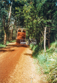
Photograph - Colour Print, Eltham Shire Council, Council oerations road grading and gravel water truck, c.1990
The cost of providing equivalent levels of services to the more rural areas of the Shire with respect to those in the more urban areas of Eltham, Montmorency and Briar Hill was relatively expensive. Road maintenance of rural unsealed gravel roads is one of those areas of higher costs particulary as a result of water erosion. The same applies for Nillumbik Shire Council today. Here we see Council operations grading a road and laying new gravel, followed by a gravel water truck to help bed the surface down. Unfortunately there is no information with these prints as to where this particular location is.graders, infrastructure, road maintenance, roads, shire of eltham, rural road, unidentified -
 Eltham District Historical Society Inc
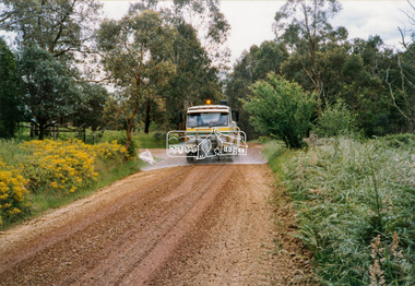
Photograph - Colour Print, Eltham Shire Council, Council oerations road grading and gravel water truck, c.1990
The cost of providing equivalent levels of services to the more rural areas of the Shire with respect to those in the more urban areas of Eltham, Montmorency and Briar Hill was relatively expensive. Road maintenance of rural unsealed gravel roads is one of those areas of higher costs particulary as a result of water erosion. The same applies for Nillumbik Shire Council today. Here we see Council operations grading a road and laying new gravel, followed by a gravel water truck to help bed the surface down. Unfortunately there is no information with these prints as to where this particular location is.graders, infrastructure, road maintenance, roads, shire of eltham, rural road, unidentified -
 Eltham District Historical Society Inc
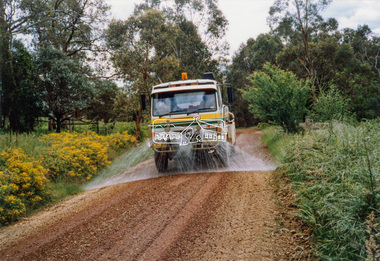
Photograph - Colour Print, Eltham Shire Council, Council oerations road grading and gravel water truck, c.1990
The cost of providing equivalent levels of services to the more rural areas of the Shire with respect to those in the more urban areas of Eltham, Montmorency and Briar Hill was relatively expensive. Road maintenance of rural unsealed gravel roads is one of those areas of higher costs particulary as a result of water erosion. The same applies for Nillumbik Shire Council today. Here we see Council operations grading a road and laying new gravel, followed by a gravel water truck to help bed the surface down. Unfortunately there is no information with these prints as to where this particular location is.graders, infrastructure, road maintenance, roads, shire of eltham, rural road, unidentified -
 Eltham District Historical Society Inc
Photograph - Colour Print, Eltham Shire Council, Council oerations road grading and gravel water truck, c.1990
The cost of providing equivalent levels of services to the more rural areas of the Shire with respect to those in the more urban areas of Eltham, Montmorency and Briar Hill was relatively expensive. Road maintenance of rural unsealed gravel roads is one of those areas of higher costs particulary as a result of water erosion. The same applies for Nillumbik Shire Council today. Here we see Council operations grading a road and laying new gravel, followed by a gravel water truck to help bed the surface down. Unfortunately there is no information with these prints as to where this particular location is.graders, infrastructure, road maintenance, roads, shire of eltham, rural road, unidentified -
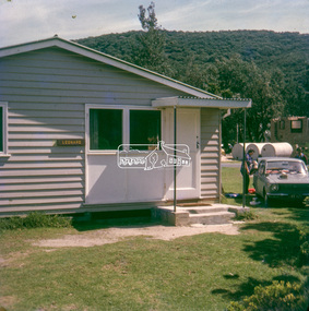 Eltham District Historical Society Inc
Slide - Photograph, Holiday cabin, Leonard, unidentified location, possibly Kinglake, c.1973
... Holiday cabin, Leonard, unidentified location, possibly... Corolla (1967) Unidentified 35mm colour positive transparency blue ...35mm colour positive transparency blue Agfacolour Service plastic mountholiday cabin, jwx677 (vic registration), leonard, toyota corolla (1967), unidentified -
 Glen Eira Historical Society
Newspaper - MELBOURNE AND METROPOLITAN TRAMWAYS: TRAMS
This file contains 2 items about the organisation. 1/Copy of photograph of horse-drawn tram. The image is of a tram behind 2 horses, unidentified tramway official, a lady and child. Date and location unknown 2/Original 4 page document including 4 images. Document is titled ‘The Development of Melbourne’s trams’ issued by the Melbourne and Metropolitan Tramways Board as part of M.M.T.B. News dated 1965. The document details the development of trams in Melbourne from 1860 followed by the 1869 formation of The Melbourne Omnibus Company and then the creation of The Melbourne and Metropolitan Tramways Board in 1919. Document covers the operations of horsedrawn trams, cable trams and electric trams and buses until 1965. Document also shows 4 images of various trams, ie horse drawn cable and electric trams.the melbourne and metropolitan tramways board (m.m.t.b), horse tramways, tram companies, trams, public transport, tram services, elsternwick railway station, land transport, glenhuntly road, caulfield railway station, glenhuntly railway station, prahran and malvern tramways trust, buses, point ormond bus, point ormond shuttle tram, tram depots, melbourne tramway and omnibus company, melbourne tramways trust, melbourne omnibus company, glenhuntly tram depot -
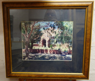 Kew Historical Society Inc
Photograph - Framed Photograph, Red Brick House
Unidentified house. KHS welcomes viewers to identify the locationFramed and glazed small photograph of a red brick house in Kew or Kew EastNilhouses - kew - kew east -
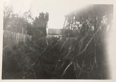 Kew Historical Society Inc
Photograph, Backyard, Kew, 1940-1965
... Overgrown backyard. Location in Kew unidentified. ... Overgrown backyard. Location in Kew unidentified. Backyard, Kew ...Overgrown backyard. Location in Kew unidentified. kew -
 Bendigo Military Museum
Photograph - 4th Field Survey Squadron deployed on Operation NERIGHT, Queensland & Northern Territory, 1989
... of GPS parties. .7) to .9) - Photo, colour, 1989. Unidentified.... .7) to .9) - Photo, colour, 1989. Unidentified soldier ...This is a set of 19 photographs taken in 1989 during 4th Field Survey Squadron’s deployment on Operation NERIGHT 89 in Queensland and the Northern Territory. It was a two-part operation in 1989 with work conducted in the areas of Camooweal and Weipa. Part 1 was the field completion of topographic maps conducted near Camooweal QLD, along the Barkley Highway on the border between NT and QLD, from the 12th of September to the 20th of October 1989. A Bell Kiowa LOH helicopter from 162 Recce Sqn supported topographic field completion. Operation NERIGHT 89 Part 2 was the acquisition of mapping control by GPS field parties utilising Texas Instruments TI4100 Global Positioning System receivers around Weipa on Cape York Peninsula from the 22nd of September to the 22nd of October 1989. Part 2 Two Bell UH-1H Iroquois helicopters from RAAF’s 35 Squadron were principally used to deploy GPS field parties. Identification photography of control points was taken by air camera operators in AAAvn Pilatus Porter aircraft from 173 Gen Spt Sqn fitted with an RC10 aerial camera. The two parts of the operation were conducted concurrently. This is a set of 19 photographs taken in 1989 during 4th Field Survey Squadron’s deployment on Operation Neright in Queensland & the Northern Territory. The colour photographs are on 35mm negative film and are part of the Army Survey Regiment’s Collection. The photographs were scanned at 96 dpi. .1) to .3) - Photo, colour, 1989. En-route to areas of survey operations. .4) to .5) - Photo, colour, 1989. Unidentified personnel relax next to river/waterhole. .6) - Photo, colour, 1989. Two Bell UH-1H Iroquois helicopters from RAAF’s 35 SQN utilised in the movement of GPS parties. .7) to .9) - Photo, colour, 1989. Unidentified soldier practices repelling from a UH1H Iroquois helicopter. .10) - Photo, colour, 1989. Inside the cockpit of a UH1H Iroquois helicopter. .11) - Photo, colour, 1989. Field Party camp with GPS equipment in foreground. Unidentified soldier prepares a meal. .12) - Photo, colour, 1989. GPS antenna plumbed over a survey ground mark. Witness post on left. .13) & .14) - Photo, colour, 1989. Unknown Cape York Peninsula beaches. .15) & .16) - Photo, colour, 1989. Dramatic fire next to base camp. .17) - Photo, colour, 1989. Aboriginal rock art at unknown location. .18) - Photo, colour, 1989. Aboriginal rock art at unknown location. L to R: unidentified, SPR Andrew Quin. .19) - Photo, colour, 1989. Aboriginal rock art at unknown location. LT Chris Topovsek..1P to .19P – There are no personnel identified. ‘1989 OP NERIGHT’ annotated on negative sleeve.royal australian survey corps, rasvy, 4 fd svy sqn, op neright 89 -
 Bendigo Military Museum
Photograph - 4th Field Survey Squadron Adventurous Training, Unknown Location, SA, 1990
This is a set of seven photographs of 4th Field Survey Squadron undergoing adventurous training held at an unknown location in South Australia, in 1990. It is probable the training focussed on teamwork, leadership, field craft and living off the land survival skills. Elements from units of the Army Reserve may have participated in the training. This is a set of seven photographs of 4th Field Survey Squadron personnel undergoing adventurous training held at an unknown location in South Australia in 1990. The colour photographs are on 35mm negative film and are part of the Army Survey Regiment’s Collection. The photographs were scanned at 96 dpi. .1) - Photo, colour, 1990. Unidentified personnel. .2) & .3) - Photo, colour, 1990. L to R: unidentified, SGT John Zuringer, unidentified. .4) - Photo, colour, 1990. L to R: SPR Pat Austine, unidentified. .5) - Photo, colour, 1990. SPR Doug Willis. .6) - Photo, colour, 1990. L to R: SPR Pat Austine, SPR Doug Willis. .7) - Photo, colour, 1990. L to R: unidentified (x2), SPR Pat Austine, SGT John Zuringer, unidentified (x2)..1P to .7P – There are no personnel identified. ‘1990 ADV TRAINING’ annotated on negatives sleeve.royal australian survey corps, rasvy, 4 fd svy sqn -
 Bendigo Military Museum
Photograph - 4th Field Survey Squadron – Operation NERVOSE 85 Field Phase, Northern Territory, 1985
This is a set of 16 photographs taken in 1985* during 4th Field Survey Squadron’s deployment on Operation NERVOSE 85 in the Northern Territory. Operation NERVOSE 85 was mounted by 4 Fd Svy Sqn in the EAST ARNHEM, VICTORIA RIVER DOWNS AND DALY WATERS areas from 26 May to 18 Sep 85. The aim of Operation NERVOSE 85 was to finalise the horizontal and vertical control for mapping at a scale of 1:50,000, to field check 40x 1:50,000 preliminary maps and to obtain mapping photography in support of the RAAF TINDAL redevelopment project. *Note –These photos were most likely taken in 1985, contrary to the ‘1987’ date annotated on the negative sleeves. The Op NERVOSE 85 Project Report available on RASVY’s web site lists a nominal roll of personnel. Photos of 4 Fd Svy Sqn taken in 1985 and 1987 provide names of posted personnel. Several personnel identified in these photos were posted to 4 Fd Svy Sqn in 1985, not in 1987. See items 6504.13P, 6505.28P and 6507.20P for more photos taken prior to and during Operation NERVOSE 1985. This is a set of 16 photographs taken in 1985 during 4th Field Survey Squadron’s deployment on Operation Nervose in the Northern Territory. The black & white photographs are on 35mm negative film and are part of the Army Survey Regiment’s Collection. The photographs were scanned at 96 dpi. ..1) & .2) - Photo, black & white, 1985. Q-store and OPS Room. .3) & .4) - Photo, black & white, 1985. Base Camp at unknown location. .5) - Photo, black & white, 1985. Personnel spectate during a social cricket match. L to R on left: CPL Andy Lucas, unidentified (x3). L to R on right: unidentified (x4), LTCOL Kevin Murphy – SO1 Svy HQ FF Comd, unidentified, SSGT Barry Lutwyche OAM (closest to camera). .6) - Photo, black & white, 1985. Personnel spectate during a social cricket match. L to R on left: unidentified (x2). L to R on right: unidentified (x3), LCPL Chris ‘Charlie’ Brown (standing up), SSGT Barry Lutwyche OAM (closest to camera), LTCOL Kevin Murphy – SO1 Svy HQ FF Comd. .7) - Photo, black & white, 1985. CPL Andy Lucas plans an exit strategy from the latrine. .8) to .10) - Photo, black & white, 1985. Social cricket match action. .11) to .14) - Photo, black & white, 1985. LCPL Chris ‘Charlie’ Brown operates a second-generation Transit Doppler satellite Magnavox MX-1502 Satellite Surveyor Geoceiver. .15) to .16) - Photo, black & white, 1985. LCPL Steve McGuiness sets up a Geoceiver antenna..1P to .16P – There are no personnel identified. ‘1987 OP NERVOSE VICTORIA RIVER DOWNS AND DALY WATERS.’ annotated on negative sleeve.royal australian survey corps, rasvy, 4 fd svy sqn, op nervose 85 -
 Bendigo Military Museum
Photograph - Royal Australian Survey Corps Surveyors in the Field – Project Cutlass, New Guinea, 1956 – 1957
This is a set of 23 photographs of surveyors and support staff in the field undertaking tasks in New Guinea 1956 – 1957. The surveyors were employed in the establishment of mapping and geodetic control for Project Cutlass, the “Ship-Shore” survey of the New Ireland province. In this survey operation surveyors used theodolites to observe horizontal and vertical angles and chains to measure base line distances between survey stations. Bob Skitch shown in photo .7P was in the 2nd year of his career in the Australian Army. He achieved the rank of Lieutenant-Colonel, and his last appointment was the CO of the Army Survey Regiment from 1976 to 1980.This is a set of 23 photographs of surveyors and support staff in the field undertaking duties during Project Cutlass located in New Ireland, New Guinea 1956 – 1957. The photographs were printed on photographic paper and are part of the Army Survey Regiment’s Collection. The photographs were scanned at 300 dpi. .1) - Photo, colour, 1956. Surveyors travelling main road from Kavieng to Namatanai, New Ireland. .2) - Photo, colour, 1956. Unidentified surveyors assessing recovery of their vehicle after bridge collapsed on west side of New Ireland. .3) - Photo, colour, 1956. Unidentified surveyors assessing recovery of their vehicle after bridge collapsed over flooded creek on west side of New Ireland. .4) - Photo, colour, 1956. Survey personnel L to R: Bev Uwins, John Lambie, Bob Thompson, New Ireland. .5) - Photo, colour, 1956. Survey base camp, New Ireland. .6) - Photo, black & white, 1956-1957. Geoff Helsham with possible human remains, New Ireland. .7) - Photo, black & white, 1956-1957. Bob Skitch undertaking survey observations using Wild T2 theodolite, New Ireland. .8) - Photo, black & white, 1956-1957. Chas Beach undertaking survey observations using Wild T2 theodolite, New Ireland. .9) & .10) - Photo, black & white, 1956-1957. Kev Parker (cook) New Ireland. .11) - Photo, colour, 1957. Brian Berkery taking a break, Top Manor Island, Lihir Island Group off New Ireland. Latitude -2° 46”, Longitude 152° 40”. .12) - Photo, colour, 1957. Survey base camp L to R: Chas Beach, Bev Uwins, Feni Islands, New Ireland. Latitude -4° 05”, Longitude 153° 45”. .13) - Photo, colour, 1957. A Hous Kiap. (Kiaps, known formally as district officers and patrol officers, were travelling representatives of the British and Australian governments), New Ireland. .14) & .15) - Photo, colour, 1957. L to R: Joe Farrington, Tom Royle Bob undertaking survey observations using theodolites from an improvised timber tower, New Ireland. .16) & .17) - Photo, colour, 1957. US Army ship FS216 used for ship-to-shore triangulation docked at Rabaul, New Britain. .18) - Photo, colour, 1957. US Army ship FS216 used for ship-to-shore triangulation docked at Kavieng, New Ireland. Sight target on top of mast. .19) - Photo, colour, 1957. Survey personnel onboard US Army ship FS392, L to R: Peter Frodsham, Bob Thompson, Doc Reid, John Underwood, remainder unidentified, New Ireland. .20) - Photo, colour, 1957. Survey base line party heading ashore, New Ireland. .21) - Photo, colour, 1957. Survey personnel rowing US Army assault boat L to R: Kev Parker, Chas Beach, folded up survey beacons overhanging stern, New Ireland. .22) - Photo, colour, 1957. Les Bailey onboard US Army ship departing Rabaul, New Britain for Brisbane. .23) - Photo, colour, 1957. Ron Newman onboard US Army ship departing Rabaul, New Britain for Brisbane. Active volcano in background..1P to .23P annotated on back – ‘Operation Cutlass’, personnel names, the year and the location. royal australian survey corps, rasvy, army survey regiment, fortuna, a, army svy regt, asr, surveying -
 Bendigo Military Museum
Photograph - RA Svy Project C4 Aerodist Operation, Eastern Arnhem Land, NT, 1967
This is a set of 30 photographs of Royal Australian Survey Corps (RA Svy) personnel from Central Comd Fd Svy Unit (Adelaide) on Aerodist survey operation - Project C4 in Eastern Arnhem Land, Northern Territory in 1967. Photos of personnel were taken either at the operations base at Numbulwar or the main base at Gove (Nhulunbuy). RA Svy conducted nineteen Aerodist operations for 12 years from 1964 to 1975. Aerodist MRC2 was a tellurometer-based system adapted for aircraft to accurately measure distances between non-intervisible ground survey stations, using the aircraft as an intermediate station. Lower order geodetic results could be achieved by survey network trilateration. The measured distances between stations formed survey networks from which each station’s latitude and longitude was computed. Aerodist MRC2 was RA Svy’s major horizontal control survey tool for mainly medium scale topographic mapping (scale 1:100,000 Class A being spatially accurate to within 50 metres) in PNG, northern NT, north-west WA, Kalimantan Barat (West) Indonesia, Sumatra Indonesia, Gulf of Carpentaria and Cape York, QLD. In 1967, the Aerodist MRC2 Master equipment was installed in the aircraft featured in this set of photos, Executive Air Services’ (Essendon VIC) Grand Aero Commander VH-EXX. It was the same aircraft type and company contracted to Division of National Mapping for Aerodist MRC2 surveys. From July to October 1967 the aircraft was attached to Central Comd Fd Svy Unit (Adelaide - Major Don Ridge) on Project C4 eastern-Arnhem Land NT, where 317 Aerodist lines measuring 17,300 line miles were successfully completed. This was the most productive Aerodist project thus far. The most common helicopter used by RA Svy up to 1972 was the civilian Bell 47G-2 and the Sioux Light Observation Helicopters (LOH), the Australian Army’s equivalent featured in this photo set. These light observation helicopters had a limiting load carrying capacity of up to about 500 pounds. By comparison, one Aerodist team including two people weighed up to 1,500 pounds. Source: Royal Australian Survey Corps – Aerodist Years 1964-1975 by Peter Jensen. This is a set of 30 photographs of Royal Australian Survey Corps (RA Svy) personnel on Aerodist survey operations in Eastern Arnhem Land, Northern Territory in 1967. The photographs are on 35mm negative film and scanned at 96 dpi. They are part of the Army Survey Regiment’s Collection. .1) to .4) - black & white, 20th August 1967, Project C4 Aerodist Operations Base - Numbulwar, NT. .5) - Photo, black & white, 1967. Probable wrecked Indonesian fishing vessel. .6) to .8) - Photo, black & white, 1967. Unidentified survey operations base, L to R: unidentified personnel. .9) - Photo, black & white, 1967. Unidentified survey operations base, unidentified soldier driving a Haflinger 4x4 Light utility vehicle. .10) - Photo, black & white, 1967. Unidentified survey operations base, L to R: unidentified technician. .11) - Unidentified technician reading two survey altimeters to compute corrections to the measured distances for atmospheric refraction and to compute the sea level distances from the slope distances aircraft to the ground stations. .12) - Photo, black & white, 1967. Unidentified survey operations base, L to R: unidentified personnel. .13) to .16) - Photo, black & white, 1967. Unidentified personnel operating remote Aerodist MRC2 ground instruments. .17) to .18) - Photo, black & white, 1967. Unknown RA Svy office location. .19) to .20) - Photo, black & white, 1967. Aerodist MRC2 Master equipment. .21) to .22) - Photo, black & white, 1967. Aero Commander VH-EXX probably at Gove, NT, Central Comd Fd Svy Unit (Adelaide) – OC Major Don Ridge. .23) to .25) - Photo, black & white, 1967. Aero Commander VH-EXX probably at Gove, NT. Unidentified personnel. .26) - Photo, black & white, 1967. Aero Commander VH-EXX probably at Gove, NT. Aerodist antenna pods are visible on the aircraft. .27) to .29) - Photo, black & white, 1967. Australian Army Sioux Light Observation Helicopter (LOH) probably at Gove, NT. .30) - Photo, black & white, 1967. Panelled U337 survey station, visible as a white cross on aerial identification photo..1P to .2P – date and location on edge of film negative. .5P to .28P – no annotations .29P - annotated in white ‘RW-JEP Gove NT’ .30P - annotated in white ‘U337 Spool No1 Jun67’royal australian survey corps, rasvy, army survey regiment, army svy regt, fortuna, asr, aerodist, surveying, central comd fd svy unit -
 Bendigo Military Museum
Photograph - Royal Australian Survey Corps - Map Production Processes, c1990
This is a collection of 20 photographs of Royal Australian Survey Corps phases of map production at the School of Military Survey, Bonegilla, the Army Survey Regiment, Bendigo, and the Army Map Depot, Bandiana circa 1990. Colour photos are on 35mm slide film and were scanned at 96 dpi. They are part of the Army Survey Regiment’s Collection. Photo .1P was probably taken on a survey station overlooking Lake Hume near Albury-Wodonga. The field party occupying the survey station was likely from a Map Control Survey course conducted by the School of Military Survey, Bonegilla. This survey station was part of a geodetic network used in field survey training and RASvy’s Lake Hume Test Range. Photos .3P to .16P were taken at the Army Survey Regiment, Bendigo and photos .17P & .18P were taken at the Army Map Depot, Bandiana. Photo .19P depicts a map of RASvy’s ARA units before the disbandment of 5th Field Survey Squadron, Perth and 2nd Field Survey Squadron, Sydney in 1990. This is a collection of 20 photographs of map production processes taken at the School of Military Survey, Bonegilla, the Army Survey Regiment, Bendigo, and the Army Map Depot, Bandiana circa 1990. Colour photos are on 35mm slide film and were scanned at 96 dpi. They are part of the Army Survey Regiment’s Collection. Photo .2P is printed on photographic and scanned at 300 dpi. .1) – Photo, colour, c1980s. Geodetic Surveying: AN/PRR-14 Geoceiver antenna on hill surrounding Lake Hume. Series 3 Land Rover, field party tent and survey station beacon in background. .2) – Photo, black & white, c1980s. Geodetic Surveying: AN/PRR-14 Geoceiver antennas set up at the School of Military Survey, Bonegilla, Victoria. .3) – Photo, colour, c1990. Aerotriangulation: Wild PUG4 point transfer device, SSGT Bruce Hammond. .4) – Photo, colour, c1990. Aerotriangulation: Zeiss (Jena) Stecometer, SSGT Bruce Hammond. .5) – Photo, colour, c1990. Aerotriangulation: computer tape maintenance, SSGT Noel McNamara. .6) – Photo, colour, c1990. AUTOMAP 2: computer tape maintenance, SPR Nadine (Paul) Read. .7) - Photo, colour, c1990s. AUTOMAP 2: Optronics 4040 scanning/film output in Lithographic Squadron, SGT Sherri (Dally) Burke. .8) - Photo, colour, c1990s. AUTOMAP 2: Benson verification plotter output, SPR Nadine (Paul) Read. .9) – Photo, colour, c1990. Aerotriangulation: data management, SGT Neil ‘Ned’ Kelly. .10) & .11) - Photo, colour, c1990s. AUTOMAP 2: Wild B8 Aviograph stereoplotter Feature Extraction, unidentified technician. .12) - Photo, colour, c1990s. AUTOMAP 2: Graphic Edit Workstation, SPR Nadine (Paul) Read. .13) - Photo, colour, c1990s. AUTOMAP 2: Graphic Edit Workstation, SPR Dawn Hoadley. .14) & .15) - Photo, colour, c1990s. AUTOMAP 2: Graphic Edit Workstation, unidentified technician. .16) – Photo, colour, c1990s. Heidelberg Speedmaster 102 computer-controlled five colour lithographic offset printing press. .17) & .18) – Photo, colour, c1990s. Army Map Depot, unidentified storeman, Bandiana. .19) – Photo, colour, c1990. RASvy ARA Unit Locations before disbandment of field units in Perth and Sydney. .20) – Photo, colour, c1990. Set of overlapping aerial photography..1P, .3P to .20P - Some equipment is identified on the frame of the 35mm slides.royal australian survey corps, rasvy, army survey regiment, army svy regt, fortuna, asr, school of military survey, army map depot -
 Bendigo Military Museum
Photograph - Royal Australian Survey Corps Surveyors in the Field, Army Survey Regiment, 1950s to 1970s
These three photographs were most likely taken from the 1950s to the 1970s. The RASvy surveyor in each photograph was taking angular measurements with the observer recording their readings on a booking form. They were probably employed in establishing mapping and geodetic control operations or the surveyors may have been in training. Photo .1P was possibly taken at Mount Alexander in Central Victoria, a location close to Bendigo, as the stone cairn in the background of the photo appears to be identical to the cairn presently located on top of the mountain. Personnel and location have been confirmed on another photo in the collection with annotation. These three photographs are of surveyors in the field undertaking observations using theodolites. The photographs were printed on photographic paper and are part of the Army Survey Regiment’s Collection. The photographs were scanned at 300 dpi. .1) - Photo, black & white, c1950s. Unidentified personnel undertaking observations with a Tavistock geodetic theodolite. .2) – Photo, colour, mounted on card, c1960s. Unidentified personnel undertaking observations with a Kern DKM2 theodolite. .3) - Photo, colour, c1970s. Unidentified personnel undertaking observations with a theodolite..1 – not annotated .2 –annotated on front “Kern DKM2, TOPO 10” royal australian survey corps, rasvy, army survey regiment, army svy regt, fortuna, asr, surveying -
 Bendigo Military Museum
Photograph - 4th Field Survey Squadron – Operation NERVOSE 85 Reconnaissance, Northern Territory, 1985
This is a set of 13 photographs taken in 1985* during reconnaissance of locations in regions of the Northern Territory. Later that year, Operation NERVOSE 85 was mounted by 4 Fd Svy Sqn in the EAST ARNHEM, VICTORIA RIVER DOWNS AND DALY WATERS areas of the Northern Territory from 26 May to 18 Sep 85. The aim of Operation NERVOSE 85 was to finalise the horizontal and vertical control for mapping at a scale of 1:50,000, to field check 40x 1:50,000 preliminary maps and to obtain mapping photography in support of the RAAF TINDAL redevelopment project. *Note –These photos were most likely taken in 1985, contrary to the ‘1987’ date annotated on the negative sleeves. The Op NERVOSE 85 Project Report available on RASVY’s web site lists a nominal roll of personnel. Photos of 4 Fd Svy Sqn taken in 1985 and 1987 provide names of posted personnel. Several personnel identified in these photos were posted to 4 Fd Svy Sqn in 1985, not in 1987.This is a set of 13 photographs taken during 4th Field Survey Squadron’s reconnaissance of Operation NERVOSE 85 locations in the Northern Territory in 1985. The colour photographs are on 35mm negative film and are part of the Army Survey Regiment’s Collection. The photographs were scanned at 96 dpi. .1) to .4) - Photo, colour, 1985. Unknown location in the Northern Territory. .5) - Photo, colour, 1985. Unidentified personnel in the back of a police vehicle. .6P to .12) - Photo, colour, 1985. Unknown location in the Northern Territory. .13) - Photo, colour, 1985. L to R: Possibly MAJ A. Vickers RE - UK Exchange Officer from Army Svy Regt, unidentified officer. .1P to .13P – There are no personnel identified. ‘1987 OP NERVOSE – RECON PHOTOG.’ annotated on negative sleeve.royal australian survey corps, rasvy, 4 fd svy sqn, op nervose 85 -
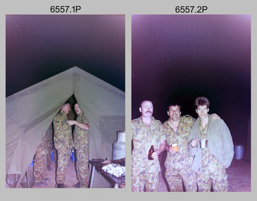
 Bendigo Military Museum
Photograph - 4th Field Survey Squadron – Operation MIZMAZE 92, Kimberley region, Western Australia, 1992
This is a set of 40 photographs taken in 1992 during 4th Field Survey Squadron’s deployment on Operation MIZMAZE 92 in the Kimberley region of Western Australia from the 13th of May to the 14th of July 1992. The area of operations was Wyndham, Halls Creek and Sandfire Flat. It was a two-part operation involving the field completion of topographic maps and the acquisition of mapping control by GPS field parties utilising Texas Instruments TI4100 Global Positioning System receivers. Survey parties conducted field checking of topographic maps and GPS control acquisition in Perentie 110 Series Survey variant FFR Land Rovers. Three Bell Kiowa LOH helicopters provided by 162 Recce Sqn supported field checking and limited deployment of GPS surveys parties. C-l30 Hercules from 36 Sqn supported deployment and extraction of personnel and equipment to and from from the AO. A Cessna 404 Titan Ambassador from Vee-H Aviation was used as the Wild RC10 camera platform for aerial photography acquisition.This is a set of 40 photographs taken in 1992 during 4th Field Survey Squadron’s deployment on Operation MIZMAZE 92 in the Kimberley region of Western Australia. The colour photographs are on 35mm negative film and are part of the Army Survey Regiment’s Collection. The photographs were scanned at 96 dpi. .1) - Photo, colour, 1992. CAPT Craig Hersant. .2) - Photo, colour, 1992. Unidentified officer/soldier. .3) & .4) - Photo, colour, 1992. Aboriginal rock art - Wandjina Gunduran, Donkey Creek. .5) - Photo, colour, 1992. Aboriginal rock art - Track Wandjinas, Donkey Creek. .6) & .7) - Photo, colour, 1992. CAPT Craig Hersant. .8) - Photo, colour, 1992. Kimberley region topography. CPL Glen Weatherell. .9) - Photo, colour, 1992. Unidentified personnel .10) - Photo, colour, 1992. Supermarket at unknown location. .11) to .13) - Photo, colour, 1992. Caravan park at unknown location. .14) - Photo, colour, 1992. Old bridge at Fitzroy Crosssing. .15) & .16) - Photo, colour, 1992. Survey party in Perentie 110 Series Land Rover. .17) & .18) - Photo, colour, 1992. Kimberley region topography. .19) - Photo, colour, 1992. Kimberley region topography. CPL Glen Weatherell. .20) - Photo, colour, 1992. Kimberley region topography, possibly the Bungle Bungles. .21) - Photo, colour, 1992. Kimberley region topography. SGT Frank Downie. .22) - Photo, colour, 1992. Kimberley region topography: the Bungle Bungles. .23) - Photo, colour, 1992. Kimberley region topography: the Bungle Bungles. .24) - Photo, colour, 1992. Kimberley region topography: the Bungle Bungles. SPR Neil Pedler. .25) & .26) - Photo, colour, 1992. Kimberley region topography: the Bungle Bungles. .27) - Photo, colour, 1992. Kimberley region topography. .28) - Photo, colour, 1992. Survey party with Perentie 110 Series Land Rover. .29) - Photo, colour, 1992. Kimberley region topography. .30) - Photo, colour, 1992. Survey party outside Perentie 110 Series Land Rover. .31) & .32) - Photo, colour, 1992. Survey party operating TI4100 GPS Receiver next to Perentie 110 Series Land Rover. SGT Eddie Jacobs. .33) & .34) - Photo, colour, 1992. Survey party operating TI4100 GPS Receiver next to Perentie 110 Series Land Rover. Unidentified surveyor. .35) - Photo, colour, 1992. Kimberley region topography. Hand water pump at well. .36) - Photo, colour, 1992. Survey party in Perentie 110 Series Land Rover. .37) - Photo, colour, 1992. Kimberley region topography. CPL Glen Weatherell. .38) - Photo, colour, 1992. Kimberley region topography viewed from Bell Kiowa LOH helicopter. .39) & .40) - Photo, colour, 1992. Unidentified surveyor field checking a preliminary map in a Bell Kiowa LOH helicopter..1P to .40P – There are no personnel identified. ‘1992 OP MIZMAZE annotated on negative sleeve.royal australian survey corps, rasvy, 4 fd svy sqn, op mizmaze 92 -
 Bendigo Military Museum
Photograph - 4th Field Survey Squadron – Operation ARIGHT 91, Queensland, 1991
This is a set of 16 photographs taken during 4th Field Survey Squadron’s deployment on Operation ARIGHT 91 in Queensland from the 8th of July to the 5th of September 1991. The area of operations was the top end of the Cape York Peninsula, islands of the Torres Strait and the southern coast of PNG. Field parties utilised Texas Instruments TI4100 Global Positioning System receivers. Concurrent with GPS operations Doppler point positioning observations were carried out by field parties using Magnavox MX 1502 receivers on six of the control points. Two Bell UH-1H Iroquois helicopters from RAAF’s 171 COMD and Liaison Squadron were primarily used to deploy GPS field parties. Identification photography of control points was taken by air camera operators in AAAvn Pilatus Porter aircraft from 173 Gen Spt Sqn fitted with an RC10 aerial camera.This is a set of 16 photographs taken in 1991 during 4th Field Survey Squadron’s deployment on Operation ARIGHT in Queensland. The colour photographs are on 35mm negative film and are part of the Army Survey Regiment’s Collection. The photographs were scanned at 96 dpi. .1) to .3) - Photo, colour, 1991. Area of Operations (AO) coordination maps. .4) - Photo, colour, 1991. GPS acquisition post-processing. L to R: LT Simon Buckpitt, SSGT Steve Winner, WO2 Ken Talbot-Smith. .5) to .6) - Photo, colour, 1991. Base camp unidentified personnel. .7) - Photo, colour, 1991. L to R: OPS WO - WO2 Ken Talbot-Smith, DET SSM WO1 Stevo Hinic. .8) - Photo, colour, 1991. Base camp unidentified personnel. .9) - Photo, colour, 1991. Base camp L to R: unidentified (x2), OPS WO - WO2 Ken Talbot-Smith. .10) - Photo, colour, 1991. Base camp unidentified soldier. .11) - Photo, colour, 1991. Base camp L to R: CPL Andy Love, unidentified, SGT Steve McGuiness. .12) - Photo, colour, 1991. Base camp at Horn Island Army Compound. .13 to .16) - Photo, colour, 1991. Unknown locations in Area of Operations..1P to .16P – There are no personnel identified. ‘1991 OP ARIGHT’ annotated on negative sleeve.royal australian survey corps, rasvy, 4 fd svy sqn, op aright 91 -
 Flagstaff Hill Maritime Museum and Village
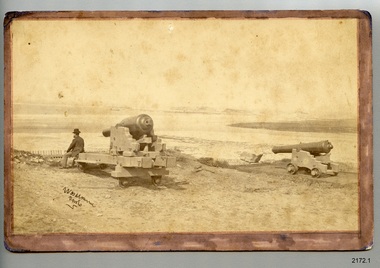
Photograph - Historical, maritime, 1878
The location of this photograph is disputed by historians, but the consensus is that is shows the early use of Flagstaff Hill by the Warrnambool Garrison. This photograph is very similar to one on file in the State Library of Victoria (SLV). The photograph in the State Library's collection is clearer, and is in black and white. It also has an inscription below it "Lady Bay, Warrnambool, 1878'. The inscription on the lower left of the SLV's photograph looks to be the same as on Flagstaff Hill's copy. The photographer is unidentified. The photograph is significant to Warrnambool's local history. It is connected to the 1870's defence of the Port of Warrnambool, and to southwest Victoria's coast. The photograph can be used as a comparative tool for measuring the changes in the landscape and the harbour.Photograph, sepia, on card. Unknown photographer. View towards Lady Bay, Warrnambool. A gentleman is seated on one of two cannon carriages with cannon, on a hill above a picket fence. A moored sailing ship is in the bay. Hills are in the background and la building is on land to the right. The photograph is mounted on card with a brown, hand coloured border on the front. The corners on the card are rounded. the reverse has round marks in the corners indicating that the photograph has been previously mounted, perhaps in an album. There is a purple stamp and some pencil inscriptions. A handwritten pen inscription is on the lower left corner of the front. [(1b) This black and white photograph is a copy of the original and has been printed on larger paper.]Front: "[undecipherable] / photo" Reverse in pencil: " REG. NO. 2172.1 / ORIGINAL" Reverse, stamped: "Flagstaff Hill Maritime Village"flagstaff hill, warrnambool, shipwrecked-coast, flagstaff-hill, flagstaff-hill-maritime-museum, maritime-museum, shipwreck-coast, flagstaff-hill-maritime-village, photograph, warrnambool, lady bay, lake pertobe, cannon hill, middle island, steam ship, breakwater, cannon, victoria, man seated on cannon, 1878, militia fort, port of warrnambool, militia, garrison, warrnambool garrison -
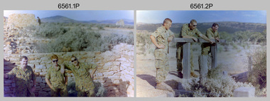 Bendigo Military Museum
Photograph - 4th Field Survey Squadron Adventurous Training, Unknown Location, SA, 1994
This is a set of 31 photographs of 4th Field Survey Squadron undergoing adventurous training held at unknown locations in South Australia, in 1994. It is also possible the training was in the Grampians region of Victoria. Off-road driver training and abseiling were key activities of this adventurous training as well as teamwork, leadership, and field craft. Elements from units of the Army Reserve may have participated in the training. See items 6562.33P, 6563.33P and 6564.28P for more photos taken during this training activity.This is a set of 31 photographs of 4th Field Survey Squadron personnel undergoing adventurous training held at unknown locations in South Australia in 1994. The colour photographs are on 35mm negative film and are part of the Army Survey Regiment’s Collection. The photographs were scanned at 96 dpi. .1) - Photo, colour, 1994. Old ruins. L to R: SGT Steve McGuiness, SPR Chris Pearse, SPR Mark Linwood. .2) - Photo, colour, 1994. Old ruins. L to R: CPL Steve Wegener, SPR Mark Linwood. SGT Steve McGuiness. .3) - Photo, colour, 1994. Old grave. SPR Mark Linwood. .4) to .7) - Photo, colour, 1994. Driver training. Unidentified personnel. .8) - Photo, colour, 1994. Driver training. CPL Steve Wegener. .9) to .12) - Photo, colour, 1994. Driver training. Unidentified personnel. .13) - Photo, colour, 1994. Driver training and hiking. L to R: SPR Greg Richards, SPR Mark McInerney. .14) - Photo, colour, 1994. Driver training and hiking. L to R: SPR Chris Pearse, WO2 Simon ‘Andy’ Capp. .15) - Photo, colour, 1994. Driver training and hiking. Unidentified personnel. .16) - Photo, colour, 1994. Driver training and hiking. L to R: CPL Steve Wegener, CAPT Rob Gray, unidentified (x2), SPR Chris Pearse, WO2 Simon ‘Andy’ Capp. .17) to .18) - Photo, colour, 1994. Driver training. Unidentified personnel. .19) - Photo, colour, 1994. Driver training and hiking. L to R: WO2 Simon ‘Andy’ Capp, SPR Chris Pearse, CPL Stuart Adrain, SPR Mark McInerney. .20) - Photo, colour, 1994. Driver training and hiking. L to R: CPL Stuart Adrain, unidentified, CAPT Rob Gray, WO2 Simon ‘Andy’ Capp, SPR Chris Pearse, SPR Mark McInerney. .21) - Photo, colour, 1994. Driver training and hiking. Unidentified personnel. .22) - Photo, colour, 1994. Driver training and hiking. L to R: unidentified, CPL Stuart Adrain, SPR Mark McInerney, CAPT Rob Gray, remainder unidentified. .23) - Photo, colour, 1994. Abseiling. L to R: SGT Steve McGuiness, unidentified, CPL Steve Wegener, CPL Stuart Adrain. .24) & .25) - Photo, colour, 1994. Abseiling. WO2 Simon ‘Andy’ Capp. .26) - Photo, colour, 1994. Abseiling. CAPT Rob Gray. .27.) to .31) - Photo, colour, 1994. Abseiling. Unidentified personnel..1P to .31P – There are no personnel identified. ‘1994 ADV TRAINING’ annotated on negatives sleeve.royal australian survey corps, rasvy, 4 fd svy sqn -
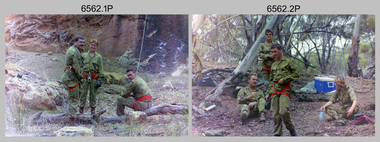 Bendigo Military Museum
Photograph - 4th Field Survey Squadron Adventurous Training, Unknown Location, SA, 1994
This is a set of 33 photographs of 4th Field Survey Squadron undergoing adventurous training held at unknown locations in South Australia, in 1994. It is also possible the training was in the Grampians region of Victoria. Off-road driver training and abseiling were key activities of this adventurous training as well as teamwork, leadership, and field craft. Elements from units of the Army Reserve may have participated in the training. See items 6561.31P, 6563.33P and 6564.28P for more photos taken during this training activity.This is a set of 33 photographs of 4th Field Survey Squadron personnel undergoing adventurous training held at unknown locations in South Australia in 1994. The colour photographs are on 35mm negative film and are part of the Army Survey Regiment’s Collection. The photographs were scanned at 96 dpi. .1) - Photo, colour, 1994. Abseiling. L to R: SGT Steve McGuiness, SPR Chris Pearse, SPR Mark McInerney. .2) - Photo, colour, 1994. Abseiling. L to R: CAPT Rob Gray, SSGT Lynn Johnson, CPL Stuart Adrain, unidentified. .3) - Photo, colour, 1994. Abseiling. Top of cliff. .4) - Photo, colour, 1994. Abseiling. L to R: Mark Linwood, unidentified. .5) - Photo, colour, 1994. Abseiling. Unidentified soldier. .6) - Photo, colour, 1994. Abseiling. Unidentified, WO2 Simon ‘Andy’ Capp. .7) & .8) - Photo, colour, 1994. Abseiling. CPL Steve Wegener. .9) & .10) - Photo, colour, 1994. Abseiling. L to R: SPR Greg Richards, unidentified. .11) - Photo, colour, 1994. Abseiling. SPR Chris Pearse, unidentified (x2). .12) & .13) - Photo, colour, 1994. Abseiling. SPR Mark McInerney. .14) - Photo, colour, 1994. Abseiling. Unidentified personnel. .15) - Photo, colour, 1994. Abseiling. SPR Marc Zehntner. .16) - Photo, colour, 1994. Abseiling. SPR Mark McInerney, unidentified. .17) & .18) - Photo, colour, 1994. Abseiling. CAPT Rob Gray. .19) - Photo, colour, 1994. Abseiling. SGT Steve McGuiness. .20) - Photo, colour, 1994. Abseiling. CPL Steve Wegener. .21) - Photo, colour, 1994. Abseiling. L to R: SPR Greg Richards, unidentified. .22) - Photo, colour, 1994. Abseiling. SPR Greg Richards. .23) to .25) - Photo, colour, 1994. Abseiling. SPR Mark Linwood. .26) - Photo, colour, 1994. Abseiling. L to R: CPL Steve Wegener, CAPT Rob Gray, unidentified. .27) & .28) - Photo, colour, 1994. Abseiling. SSGT Lynn Johnson. .29) - Photo, colour, 1994. Abseiling. SGT Steve McGuiness. .30) - Photo, colour, 1994. Abseiling. Unidentified soldier. .31) - Photo, colour, 1994. Abseiling. SPR Mark McInerney. .32) - Photo, colour, 1994. Abseiling. CAPT Rob Gray. .33) - Photo, colour, 1994. Abseiling. Unidentified soldier..1P to .33P – There are no personnel identified. ‘1994 ADV TRAINING’ annotated on negatives sleeve.royal australian survey corps, rasvy, 4 fd svy sqn -
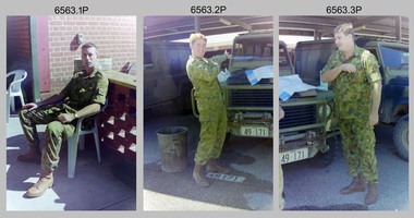 Bendigo Military Museum
Photograph - 4th Field Survey Squadron Adventurous Training, Unknown Location, SA, 1994
This is a set of 33 photographs of 4th Field Survey Squadron undergoing adventurous training held at unknown locations in South Australia, in 1994. It is also possible the training was in the Grampians region of Victoria. Off-road driver training and abseiling were key activities of this adventurous training as well as teamwork, leadership, and field craft. Elements from units of the Army Reserve may have participated in the training. See items 6561.31P, 6562.33P and 6564.28P for more photos taken during this training activity.This is a set of 33 photographs of 4th Field Survey Squadron personnel undergoing adventurous training held at unknown locations in South Australia in 1994. The colour photographs are on 35mm negative film and are part of the Army Survey Regiment’s Collection. The photographs were scanned at 96 dpi. .1) - Photo, colour, 1994. Preparation. LCPL Mitch Oake. .2) - Photo, colour, 1994. Preparation. SPR Chris Pearse. .3) & .4) - Photo, colour, 1994. Preparation. Unidentified soldier. .5) - Photo, colour, 1994. Preparation. SSGT Pat ‘Fuji’ Drover. .6) - Photo, colour, 1994. Preparation. L to R: SGT Steve McGuiness, CPL Steve Wegener, CPL Dick Crawford, CPL Peter Ball, SPR Greg Richards. .7) - Photo, colour, 1994. Preparation. L to R: CPL Peter Ball, SPR Greg Richards. .8) to .10) - Photo, colour, 1994. Preparation. SSGT Lynn Johnson. .11) - Photo, colour, 1994. Social activities. L to R: Unidentified (x8), SPR Chris Pearse, SSGT Lynn Johnson. .12) - Photo, colour, 1994. Social activities. SGT Dave Longbottom. .13) to .15) - Photo, colour, 1994. Social activities. Unidentified personnel. .16) - Photo, colour, 1994. Social activities. L to R: SGT Dave Cook, WO2 Simon ‘Andy’ Capp, CAPT Rob Gray, SPR Chris Pearse, SPR Mark McInerney. .17) to .19) - Photo, colour, 1994. Training area terrain. .20) to .23) - Photo, colour, 1994. Driver training. .24) - Photo, colour, 1994. Training area terrain. .25) - Photo, colour, 1994. Abseiling. SSGT Pat ‘Fuji’ Drover. .26) - Photo, colour, 1994. Abseiling. SGT Mark Donnelly. .27) to .33)- Photo, colour, 1994. Abseiling. Unidentified soldier. .1P to .33P – There are no personnel identified. ‘1994 ADV TRAINING’ annotated on negatives sleeve.royal australian survey corps, rasvy, 4 fd svy sqn -
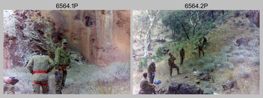 Bendigo Military Museum
Photograph - 4th Field Survey Squadron Adventurous Training, Unknown Location, SA, 1994
This is a set of 28 photographs of 4th Field Survey Squadron undergoing adventurous training held at unknown locations in South Australia, in 1994. It is also possible the training was in the Grampians region of Victoria. Off-road driver training and abseiling were key activities of this adventurous training as well as teamwork, leadership, and field craft. Elements from units of the Army Reserve may have participated in the training. See items 6561.31P, 6562.33P and 6563.33P for more photos taken during this training activity.This is a set of 28 photographs of 4th Field Survey Squadron personnel undergoing adventurous training held at unknown locations in South Australia in 1994. The colour photographs are on 35mm negative film and are part of the Army Survey Regiment’s Collection. The photographs were scanned at 96 dpi. .1) - Photo, colour, 1994. Abseiling. Unidentified personnel. .2) - Photo, colour, 1994. Abseiling. L to R: Unidentified (x2), WO2 Ken Talbot-Smith, unidentified, SGT Mark Donnelly, unidentified. .3) to .10) - Photo, colour, 1994. Training area terrain. .11) to .12) - Photo, colour, 1994. Abseiling. Unidentified personnel. .13) to .14) - Photo, colour, 1994. Training area terrain. .15) - Photo, colour, 1994. Training area terrain. L to R: SSGT Brian ‘BC’ Collings, unidentified (x6). .16) - Photo, colour, 1994. Training area terrain. .17) - Photo, colour, 1994. Training area terrain. Unidentified personnel. .18) - Photo, colour, 1994. Training area terrain. L to R: SSGT Brian ‘BC’ Collings, SGT Steve McGuiness. .19) - Photo, colour, 1994. Training area terrain. .20) to .27) - Photo, colour, 1994. Abseiling. Unidentified soldiers. .28) - Photo, colour, 1994. Returning to 4 Fd Svy Sqn. L to R: SPR Fran Calvert, unidentified, SPR Gordon Santo, SPR Matt Arnold, SGT Dave Cook..1P to .28P – There are no personnel identified. ‘1994 ADV TRAINING’ annotated on negatives sleeve.royal australian survey corps, rasvy, 4 fd svy sqn -
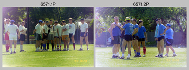 Bendigo Military Museum
Photograph - 4th Field Survey Squadron Soccer Match. Adelaide, SA, 1994
This is a selection of 30 photographs of 4th Field Survey Squadron personnel participating in a soccer game, between the Other Ranks (ORs) and Officers/Warrant Officers/Senior Non-Commissioned Officers (OFFR/SNCOs), at an unknown location in Adelaide, South Australia on the 28th of October 1994.This is a selection of 30 photographs of 4th Field Survey Squadron personnel participating in a soccer game at an unknown location in Adelaide, South Australia on the 28th of October 1994. The colour photographs are part of a set of 72 photographs on 35mm negative film and are part of the Army Survey Regiment’s Collection. The photographs were scanned at 96 dpi. .1) - Photo, colour, 1994. OFFR/SNCOs L to R: SSGT A. Simcock. WO2 Peter Hammer, SGT Peter Hardy, unidentified, SSGT Brian Collings, unidentified, WO2 Simon ‘Andy’ Capp, SGT H. Evertz, OC MAJ Peter Demaine, unidentified, CAPT Chris Topovsek. .2) - Photo, colour, 1994. ORs L to R: unidentified (x3), CPL Steve Wegener, CPL Dick Crawford, unidentified, LCPL Mitch Oake, unidentified. .3) - Photo, colour, 1994. L to R: CAPT Chris Topovsek, SGT Steve McGuiness, LCPL Mitch Oake, WO2 Simon ‘Andy’ Capp, unidentified. .4) - Photo, colour, 1994. L to R: unidentified, CPL Steve Wegener. .5) - Photo, colour, 1994. L to R: WO2 Simon ‘Andy’ Capp, SSGT Pat ‘Fuji’ Drover, unidentified. .6) - Photo, colour, 1994. L to R: unidentified (x2). .7) - Photo, colour, 1994. L to R: SSGT A. Simcock, SPR Mark Linwood, SPR Mark McInerney, unidentified, CPL Dick Crawford. .8) - Photo, colour, 1994. CPL Dick Crawford. .9) - Photo, colour, 1994. L to R: unidentified, SGT Steve McGuiness, SPR Mark Linwood, SPR Mark McInerney, SSGT A. Simcock. .10) - Photo, colour, 1994. CPL Dick Crawford taking an indirect penalty. The wall L to R: SGT H. Evertz, WO2 Simon ‘Andy’ Capp, SSGT Pat ‘Fuji’ Drover, SGT Dave Longbottom. .11) - Photo, colour, 1994. OFFR/SNCOs half time L to R: OC MAJ Peter Demaine, unidentified, SGT Dave Longbottom, SSGT A. Simcock, unidentified, SGT Steve McGuiness, unidentified, WO2 Peter Hammer. .12) - Photo, colour, 1994. ORs half time L to R: unidentified, SPR Mark Linwood, CPL Peter Ball, CPL Steve Wegener, unidentified. .13) - Photo, colour, 1994. L to R: unidentified (x2), SPR Fran Calvert. .14) - Photo, colour, 1994. L to R: Unidentified, SPR Fran Calvert. .15) - Photo, colour, 1994. L to R: CPL Phuc ‘Charlie’ Tran, SPR Fran Calvert. .16) - Photo, colour, 1994. L to R: unidentified, SPR Mark Linwood, CPL Peter Ball. .17) & .18) - Photo, colour, 1994. Attempted goal. .19) - Photo, colour, 1994. L to R: unidentified, (x2), CPL Peter Ball, LT Andrew Caudle, SGT Steve McGuiness, CPL Dick Crawford, SSGT Pat ‘Fuji’ Drover. .20) - Photo, colour, 1994. SPR Fran Calvert tackled from behind. .21) - Photo, colour, 1994. Attempted goal. L to R: CPL Phuc ‘Charlie’ Tran, SPR Fran Calvert, remainder unidentified. .22) - Photo, colour, 1994. Goal celebration. L to R: CPL Phuc ‘Charlie’ Tran, SPR Fran Calvert, remainder unidentified. .23) - Photo, colour, 1994. Attempted goal. L to R: SGT Steve McGuiness, CPL Phuc ‘Charlie’ Tran, CPL Peter Ball, SGT Dave Longbottom. .24) - Photo, colour, 1994. Attempted goal. Keeper CPL Steve Wegener under pressure. .25) - Photo, colour, 1994. Goal scored. L to R: CPL Dick Crawford, remainder unidentified. .26) - Photo, colour, 1994. Keeper clearance L to R: SGT Steve McGuiness, CPL Dick Crawford, SGT Dave Longbottom. .27) - Photo, colour, 1994. L to R: SGT Steve McGuiness, OC MAJ Peter Demaine, SGT H. Evertz, CPL Peter Ball, CPL Phuc ‘Charlie’ Tran (eyes not on the ball), SGT Dave Longbottom. .28) - Photo, colour, 1994. Keeper saves extreme pressure L to R: unidentified, (x2), Dick Crawford, SGT Dave Longbottom, CPL Steve Wegener, unidentified. In foreground: unidentified (x2). .29) - Photo, colour, 1994. Skilled footwork L to R: SSGT Brian Collings, SPR Fran Calvert, WO2 Simon ‘Andy’ Capp. In background: unidentified, SSGT Pat ‘Fuji’ Drover. .30) - Photo, colour, 1994. L to R: unidentified, CPL Dick Crawford, OC MAJ Peter Demaine, SGT Dave Longbottom..1P to .30P – There are no personnel identified. ‘1994 OCT SOCCER MATCH ORs v OFFR/SNCOs’ annotated on negatives sleeve.royal australian survey corps, rasvy, 4 fd svy sqn -
 Eltham District Historical Society Inc
Audio - Audio Compact Cassette Tape, Audio Recording; Garnet Burges, Frank Burgoyne and Jock Read reminisce about earlier times in Eltham, 2 June 1988, 1988
Long time Eltham identities, Garnet Burges, Frank Burgoyne and Jock Read reminisce about Eltham in earlier years and comparisons with that of 1988. Facillitated by unidentified younger man.Three compact cassette audio tapes, TDK D60. Each tape labeled "G.B., F.B., J.R. 2/6/88" with Copy 1, 2 or 3 of 3 and "Dolby B" Location of Copy 1 to be determined Also Compact Disc with two MP3 files, copies of Sides A and B of Compact Cassette No. 1. Converted to MP3 files: EDHS_05005-1, Tape 1, Side A; 41.7MB; 0:30:25 EDHS_05005-2, Tape 1, Side B; 41.8MB; 0:30:27 EDHS_05005-3, Tape 2, Side A; 42.3MB; 0:30:51 EDHS_05005-4, Tape 2, Side B; 42.4MB; 0:30:52 EDHS_05005-5, Tape 3, Side A; 42.2MB; 0:30:44 EDHS_05005-6, Tape 3, Side B; 10.2MB; 0:07:29 EDHS_05005, Tapes 1-3; 184MB; 2:40:47audio cassette, audio recording, eltham, frank burgoyne, garnet burges, jock read, oral history -
 Linton and District Historical Society Inc
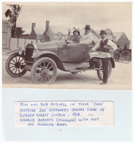
Photograph, W. Harrison Lee, Photographer and Postcard Publisher, Wonthaggi, Vic, Min and Bob Mitchell with Charles Roberts and Ford motor car, 1918
Postcard - black and white photograph of Min and Bob Mitchell, who are sitting in a Ford motor car. Charles Roberts, wearing grocer's apron, is standing next to the car, with one foot on its running board. The car is parked in Sussex Street, Linton. The Linton fire station can just be glimpsed on the left side of the photograph. A horse-drawn cart, with a man sitting in it and another man at the side of it, is in the background. A message from an unidentified writer is on the back of the card, it is dated 1918. Handwritten information identifying the subjects and location of the photograph is on a white label which appears to have once been attached to the postcard.On the back of the card, from unidentified writer: "Wonthaggi / 30/10/18" / "Dear Chas, Many times I have intended to drop you a line but as per usual did not - we had a find trip right through & have often thought of you & mentioned our meeting you to old pals - hope you are O.K. - we are "in the pink" ".wilhelmina (min) mitchell, wilhelmina angus, robert (bob) mitchell, charles roberts, ford car -
 Bendigo Military Museum
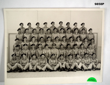
Photograph
Unidentified Army unit in a posed photograph c.1950's.Black and white photo of a platoon of Australian Soldiers of an unidentified unit. Possibly National Service given the age profile. On the back is a list of names (15 No.) out of 52 soldiers in the photo. The names look like signatures of individuals in question.15 signatures on back, some with location.photograph, army unit