Showing 1281 items matching "victorian maps"
-
 Warrnambool and District Historical Society Inc.
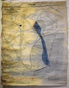
Map - Map of Proposed Alterations to Warrnambool Harbour 1925, Warrnambool Harbour Committee, Warrnambool Harbour Proposed Wharves and Basin in Lake Pertobe with Eastern Wall, 1925
This map was printed in 1925 and contains the Warrnambool Harbour alterations proposed by the Warrnambool Harbour Committee incorporating the original designs of Captain Menzies, the Warrnambool Harbour Master and the City Engineer, Mr A. Lavercombe. The main features of the proposal were the extension of the Eastern Wall to almost enclose the harbour and a basin in Lake Pertobe. The design was to be placed before the Victorian Royal Commission on the Outer Ports which was established partly to examine the allegations of unsatisfactory work carried out in Warrnambool when the Breakwater was extended 300 feet in 1914 and also to make recommendations regarding all regional ports. The Warrnambool Breakwater was completed in 1890 but failed to provide the shipping conditions needed to continue Warrnambool as a viable port. Many plans and proposals for port improvement such as this one were produced in the late 19th century and the first half of the 20th century with the port officially closed in the 1940s. Still today the Breakwater and Warrnambool Harbour conditions remain a source of contention.This map is significant as it shows a 1925 design for Warrnambool Harbour hitherto little-known. It also has markings showing land sites of the time (BayView Hotel, Woollen Mill etc.)This is a map made of thick yellow paper pasted onto a cloth backing. It has two cloth tags at the top for tying up the map when folded. It appears to be a hand-drawn map copied with printed material added. The map is shaded green and red in some areas. Attached by nails to the map are wooden frames, rounded at the bottom and partly curved at the top. The map is torn and partly detached at the top. The top frame has a cord attached for hanging the map.warrnambool harbour, captain menzies, a.lavercombe city engineer, warrnambool breakwater, royal commission on outer ports -
 Warrnambool and District Historical Society Inc.
Map, Department of Lands and Survey (Lithographers), Caramut township, 1938
This map of the township of Caramut was produced in 1938 but shows the original land owners of each town allotment and of the surrounding area. The size of all the allotments and the date of the original purchase are also shown. Caramut is a Victorian Western District town on Mustons Creek on the Hamilton Highway 48 kilometres from Warrnambool. This map was used by Rolf Crawley when he was the engineer for the Shire of Warrnambool from 1935 to 1968. The annotations on the map have probably been made by Rolf Crawley as they refer to the records and letter books of his father, John William Crawley, Junior (Shire of Warrnambool Engineer 1895 to 1935). Both Rolf Crawley and his father, John had private businesses as architects, surveyors and engineers and the map could have been used in connection with both their official Shire duties and their private businesses. The last owner of the map was the surveyor, Michael Hand who took over the business of Rolf Crawley in the late 1960s. This map is of great interest firstly because it has all the historical details of the land first purchased in the town of Caramut and area and secondly because it came from the office of Rolf Crawley, the engineer for the Shire of Warrnambool from 1935 to 1968. This is a buff-coloured paper map with a cloth backing. The map details are in black and white print. There are some handwritten red and black annotations on the map. “Town of Caramut Parish of Caramut County of Villiers’town of caramut, john william crawley junior, warrnambool, rolf crawley, warrnambool -
 Warrnambool and District Historical Society Inc.
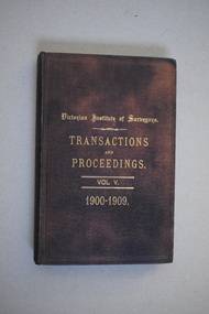
Book, Victorian Institute of Surveyors Transactions and Proceedings Vol V, 1910
This book belonged to John William Crawley, Junior who had acquired it in 1910 as a member of the Victorian Institute of Surveyors. John Crawley was an engineer, architect and surveyor in private practice in Warrnambool and also the official engineer of the Shire of Warrnambool from 1896 to 1935. His father, brother and son were also engineers and worked in that capacity for the Shire of Warrnambool or as the Shire Secretary, with the Crawley family members recording a total of 132 years of service to the Shire of Warrnambool which existed from 1863 to 1994. This book is retained as it belonged to John Crawley, the engineer for the Shire of Warrnambool for forty years. This is a hard cover book with a dark brown cover with gold printing on the front cover and spine. The cover is now stained. The book contains an introduction, twenty papers and reports from 1905 to 1910. There are many black and white photographs and fold-out maps and plans. The signature on the second page is handwritten in black ink. J.W.Crawley W’bool 26.3.10crawley family, warrnambool, shire of warrnambool, history of warrnambool -
 Warrnambool and District Historical Society Inc.
Original Document, Map: Agricultural area of Ballangeich 1865, 1865
George Eddington arrived in Australia in 1839 and named and established property in 1841 calling the property Ballangeich after a Pass near his home town of Stirling in Scotland. It is situated 151 miles west of Melbourne and to the south of Mortlake and was originally part of the Mortlake shire, which was proclaimed 26th Jan 1864. Nearest streams are the Hopkins Riverand Lyall and Drysdale creek running through good agricultural land. This map relates to the breaking up of large runs which the Victorian government enabled through selection acts of the 1860's. The previously larger runs which were mainly cattle and sheep based were now more open to closer settlement and a greater variety in farming.The lots range in size from approximately 50 acres to around 600 acres.Some areas are set aside for reserves. By 1886 the population of Ballangeich had grown to around 600 with an hotel, three state schools and a church.Tri weekly coaches ran to Colac, Warrnambool and Camperdown providing access to supplies mail and communication. This map is typical of many which were produced in the 1860's in Victoria during a significant period of Victoria's and Warrnambool district history.Rectangular light card paper with black text showing allotments of land The area is coloured in green with scale at bottom right cornerAt the top: Plan of the Agricultural area of Ballangeich 1865 At the bottom left: Prepared by the Board of Lands & Works in accordance with the Amending Land Act 1865 Lands & Survey Office Melbourne 13th April 1865. With signaturehistory of warrnambool, ballangeich, land surveys victoria 1865, lands act 1865 victoria, ballangeich map 1865 -
 Warrnambool and District Historical Society Inc.
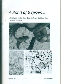
Booklet, A band of gypsies: employees of Niel Black & Co in the pre-goldrush era: a work in progress
Niel Black was an early settler in the Western District of Victoria who held large tracts of land including Glenormiston and The Sisters estates. Black was responsible for bringing many employees to the area. The employees' names, birthplace, arrival date, marriage partner/s, other employers are tabulated. An overview of Black's properties and conditions of the time is also included.This booklet documents those who came to the Western District to work for Niel Black prior to the goldfishes of the 1850s.In-house booklet with plastic sleeve outer cover, with black & white images of sheep shears, wool and a map of the Black property. All text is in black.emigration, employment, family history, early victorian squatters -
 Warrnambool and District Historical Society Inc.
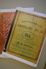
Booklet - School Exercise Books, late 19th century
school exercise book.1 These are 35 photocopied pages of an exercise book. The cover is green with black writing. The pages contain handwritten material and mathematical exercises and maps. .2 These are 17 photocopied pages of a exercise book. The cover is brown with a mottled pattern. The pages contain handwritten material, mathematical exercises and maps. fictionschool exercise bookschool exercise books, panmure state school, vickers family of panmure -
 Eltham District Historical Society Inc
Document (Item) - Book, City of Heidelberg, Restructuring Local Government for the 21st Century: Heidelberg's approach to the North East Region, February 1994
The City of Heidelberg's Council first preference is "no change" [to municipal restructure] but if this option is unacceptable, the Council would prefer to form larger municipality/municapilites involving the exisitng City of Heidelberg and the Shires of Diamond Valley and Eltham. This report includes an exective summary, Introduction, A Brief History, Heidelberg and its [municiapl] neighbours now, opportunities for restructure, detailed analysis and preferred structure. Includes fold out maps.This report by the City of Heidleberg is a significant local contribution in the consultation leading to a significant change to local government in Victorian when, in 1994 the Kennett State government restructed local government. The reforms dissolved 201 Councils and created 78 new councils through amalgamations. In suburban Melbourne 53 municipalities were reduced to 26. The City of Heidelberg was amalgamated with parts of the Shire of Eltham and Diamond Valley to become the City of Banyule.annexation, council amalgamation, local government -
 Eltham District Historical Society Inc
Document - Property Binder, 725 Main Road, Eltham
Photocopy (A4): Map hand drawn by Peter Grier, brother to Wendy Wilson, commissioned by jeweler, Michael Wilson showing his business 'Eltham Goldsmithery' c.1979-1981. Newspaper article: Art and design venue, Diamond Valley News, August 14, 1996, p14 where it is announced that the business has been approved as an outlet for Italian design house Alessi. In same article a reference to an exhibition by the deceased 'Twenty Melbourne Painters' hanging at the Victorian Artists Society Gallery and former and present day connections with Eltham area including Angela Abbott, Peter Glass, Alan Martin, Lesley Martin, Max Meldrum, Percy Leason, Alice Bale, Walter Withers, Margery Withers, Richard Mccann. (On p13 letters to the Editor about protesting against inappropriate development and the Commissioners plans for future elected Nillumbik Council structural representation). Advertisement 19 June 2013, Michael Wilson diamond jewellers. Advertising flier 23 November 2020, Michael Wilson.main road, eltham, property, houses, shops, businesses, michael wilson jewellers, peter grier, map, eltham goldsmithery, artisans minting, cafe de chin, diamond valley railway, eltham barrel, eltham clinic, eltham collegeeltham hotel, eltham community centre, eltham gallery, eltham railway station, eltham shopping centre, eltham town park, gallery 4, john mills pottery, living and learning centre, montsalvatcountry arts store, once upon a time land, shillinglaw cottagewiregrass gallery, wingrove park, michael wilson diamond jewellers -
 Eltham District Historical Society Inc
Document - Folder, Survey Maps and Technical Drawings
alan gardiner collection, maps -
 Eltham District Historical Society Inc
Book, Melbourne and Metropolitan Board of Works, Plenty River Inventory, 1986
The Melbourne and metropolitan Board of Works provided the lead agency role for implementing the Urban Waterways Program announced by the Victorian Government in February 1985. -
 Eltham District Historical Society Inc
Book, Melbourne and Metropolitan Board of Works, Diamond Creek Inventory, January 1986
The Melbourne and metropolitan Board of Works provided the lead agency role for implementing the Urban Waterways Program announced by the Victorian Government in February 1985. -
 Glen Eira Historical Society
Article - Trinity Congregational Church, Glen Huntly
Handwritten undated notes (refer History of Primitive Methodism in Victoria and Tasmania – Rev. M Clarke). Article includes style of church building, history of building and interior decoration. Also includes history of some monetary donations, purchasing of land and church opening , small handdrawn map showing where church was before removal to current site. Reprinted articles from The Victorian Independant dated January 1910 and November 1909 on the opening of the Glen Huntly venture and the Revs who participated, and then the beginning of some committees, & Fellowship groups. Also mentions the appointment of Ivan Stebbins for six months.trinity congregational church, glen huntly, tennis, grange road, mercy g.g., bevan dr., primitive methodist church, dovan a. p. rev., holley j. j. rev., eastern road., freeman w, jones j. w. rev., south melbourne, griffith a. j. rev., devenish a. s. rev., lord. t, gosman dr, jones alfred., bryant. s, stebbins ivan, orr mr., billinghurst mr, copper mr, tregaskis mr., davidson mr., congregational hall, halls, wharington mrs., pavell g., rosstown, holden mr., bishop mr., sunday schools, white a. f., cockfield mr., orr mrs., billinghurst mrs., davidson mrs., o’ donnell miss, watkins miss., billinghurst miss., davidson miss., griffith mr., newing mr. -
 Glen Eira Historical Society
Photograph - Hawthorn Road, 342, Caulfield
Two items about this address: 1/Two colour photos of a commercial building under construction on Hawthorn Road in September 1987. Building is south of Glenhuntly Road on western side And was being built for Caulfield City Council. 2/Print of comment entered 03/03/2019 on Victorian Collections website for this file from reader Angus giving street number as '342'. Google map photo print done 04/04/2019 confirms this.hawthorn road, caulfield, caulfield city council, commercial buildings, council buildings -
 Eltham District Historical Society Inc
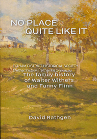
Book, David Rathgen, No Place Quite Like It; The family history of Walter Withers and Fanny Flinn, 2023
Summary For over 250 years the Withers family of Birmingham worked as tailors, sometimes also as butchers. During the Georgian era, English society changed and the Withers family with it. First came a gentleman amateur artist in the form of Edward Weston Withers, grandfather of Walter Withers. Then Edwin Withers, Walter Withers' father, took to tobacco, rope and twine manufacturing which put an end to the traditions of butchery and tailoring.The origins of Walter's painterly ambitions are explored. There was a physical altercation between Walter and his father, Edwin. That fight emerged out of contradictory expectations between Walter's father, Edwin and his grandfather Edward. Those expectations and the societies which kindled them contributed to Walter's character and art. Up until now there has been no family history about Walter Herbert Withers (1854-1914) a notable Australian landscape artist of the Heidelberg school and friend to Tom Roberts, Frederick McCubbin, Arthur Streeton and Clara Southern. Walter, the son of a rich Victorian businessman, married Fanny Flinn, the daughter of a commercial salesman who also owned part of a Birmingham brewery. In No Place Quite Like It, Walter, his wife Fanny and his family are depicted against the social contexts in which they each grew up. Our appreciation of Walter Withers' art is expanded: by knowing those forces which helped shape his early years and how he responded to them; by gaining new insights into his origins and how he grew into the man he was. We also gain a fresh appreciation of his wife Fanny, and the influence she had upon him, their children, and upon the society in which she lived. Includes 200 pages of text, Prefaces by Andrew Mackenzie OAM (art historian), and Eileen Mackley AM (President, Victorian Artists Society), Bibliography and an Index, extensive images, maps, charts and family trees, provide a visual porthole through which an insight might be had into the lives and times of Walter Withers and his family history.walter withers, fanny withers (nee flinn), family history -
Glen Eira Historical Society
Plan - Chinese Community in Glen Eira
Three pages on Chinese in Glen Eira. One hand drawn map of residents living in surrounds of Murton Hall, Chinese Church from SANDS AND MCDOUGALLS 1914 edition by Claire Barton. Printed page from FILE 1234 on Thomson Memorial Church. Hand written Chinese gardeners and related associations from SANDS AND MCDOUGALLS. Page from PROV Book 2013 with a Victorian Garden License.ruby street, reeves william, murton hall, chinese church, malva street, beattie rev. j., ocean street, gould mrs. s., belmont, house names, munn harry, maud street, ormond hall, taylor herbert, raymond rev. h., north road -
Glen Eira Historical Society
Document - Balaclava Road, 34, St Kilda East
A photocopy, 3 pages, of the Caulfield Conservation Study report on house formerly known as Noris, Quethiock and also Koala, located at Balaclava Road, 34, Caulfield, by Andrew Ward, dated 04/1993. Includes a description of the house, its condition, integrity, history, a statement of its significance, two black and white photographs (100mm x 70mm, 95mm x 70mm) of the house from different perspectives and a street map (160mm x 90mm) of the surrounding area with handwritten annotations.east louisa, alexandra street, balmoral court, beckwith thomas w, noris, quethiock, koala, wertheimer adolph, taunton james colonel, rosenhain oscar, rosenhain louise, victorian style, mansions, cuming william, ward andrew, cuming smith and co, johnson alfred, architectural styles, architectural features, balaclava road, ward andrew, st kilda east -
 Eltham District Historical Society Inc
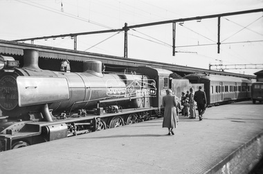
Photograph, George Coop, Steam locomotive N-430 and the Victorian Centenary Jubilee train at Spencer Street Railway Station, Feb. 1951
The Centenary-Jubilee Train. The Centenary-Jubilee train was one of the outstanding successes of the Centenary and Jubilee celebrations in Victoria. The train, attractively painted green and gold, consisted of eleven cars, and toured Victoria to take to people in the country exhibits of interest associated with the celebrations. National Art Gallery paintings, rare manuscripts and pictures were displayed, as well as models showing the history of gold production, and models and illustrations of national projects controlled by the various departments of this State. The Commonwealth section included displays by the Army, Navy, Air Force and Post Office; a war materials exhibit from the Supply Department; and diagrams and maps of the Snowy Mountains Hydro-Electric scheme. The Railways exhibit portrayed the century's growth and development of railways in Victoria and their influence on the prosperity of the State. During its 6,000 miles tour, from 1st February to 30th June, the train visited 168 stations and was inspected by 547,978 people. An entertainment unit accompanied the train and gave 100 performances which were attended by 96,400 people. Source: Report of The Victorian Railways Commissioners for the Year Ended 30th June 1951Digital TIFF file Scan of Kopdak 620 black and white negative transparencygeorge coop collection, n-430, n-class steam locomotive, victorian centenary jubilee 1951 -
 Eltham District Historical Society Inc
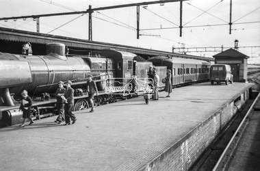
Photograph, George Coop, Steam locomotive N-430 and the Victorian Centenary Jubilee train at Spencer Street Railway Station, Feb. 1951
The Centenary-Jubilee Train. The Centenary-Jubilee train was one of the outstanding successes of the Centenary and Jubilee celebrations in Victoria. The train, attractively painted green and gold, consisted of eleven cars, and toured Victoria to take to people in the country exhibits of interest associated with the celebrations. National Art Gallery paintings, rare manuscripts and pictures were displayed, as well as models showing the history of gold production, and models and illustrations of national projects controlled by the various departments of this State. The Commonwealth section included displays by the Army, Navy, Air Force and Post Office; a war materials exhibit from the Supply Department; and diagrams and maps of the Snowy Mountains Hydro-Electric scheme. The Railways exhibit portrayed the century's growth and development of railways in Victoria and their influence on the prosperity of the State. During its 6,000 miles tour, from 1st February to 30th June, the train visited 168 stations and was inspected by 547,978 people. An entertainment unit accompanied the train and gave 100 performances which were attended by 96,400 people. Source: Report of The Victorian Railways Commissioners for the Year Ended 30th June 1951Digital TIFF file Scan of Kopdak 620 black and white negative transparencygeorge coop collection, n-430, n-class steam locomotive, victorian centenary jubilee 1951 -
 Eltham District Historical Society Inc
Folder, Victorian Goldfields Project: Historic gold mining sites in St Andrews mining division, 1999
Heritage site report and gazetteer by David Bannear, head consultant for archealogy for the Department of Natural Resources and Environment. Includes information on the Warrandyte Goldfield and the Caledonia Goldfield, Queenstown (now known as St Andrews), One Tree Hill, Kingston (now known as Panton Hill), Kangaroo Grounds, You You Hill, Kingstown, South Morang, Nillumbik, (now known as Diamond Creek), Steele's Creek, Yarrambet and Kinglake. Photocopy of map headed: Location of mines and reefs from Geological survey of Victoria, Yan Yean with the Diamond Creek prominant on the map. no date35 page report with map and print out of cover letter (email form) from donorcaledonian gold fields, caledonina gold field, david bannear, gold mining, harry gilham collection, queenstown, st andrews, warrandyte goldfield -
 Eltham District Historical Society Inc
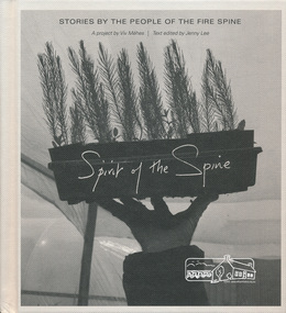
Book, Spirit of the spine: stories by the people of the fire spine, 2013
Stories of courage, inspiration and healing in the wake of the North East Victorian bush fires. Photographer Viv Mehés spent more than 3 years taking photographs and talking with local people about the 2009 firestorm and its legacy. Includes first-hand experiences of people affected by these fires — the stories here are their stories. - https://www.blacksaturdaymuseum.com/SpiritOfTheSpine.htm Includes map of area covered. black saturday, bushfire, victorian bushfires - 2009, viv mehes -
 Marysville & District Historical Society
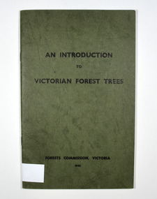
Book - Paperback book, An Introduction to Victorian Forest Trees, 1961
A history of forestry in Victoria Paperback. Cover is green with only the title on the front cover. On the inside back cover is a map of Victoria with the state forests indicated.Stamp of Marysville & District / Historical Society Inc / P.O. Box 22 / Marysville 3779victoria, forestry, forest, trees -
 Marysville & District Historical Society
Book, Picturesque Victoria, 1908
Paperback. Front cover has an illustration of a steam train sitting on railway tracks. There is a fold-out map of Victoria in the middle of the book.Stamp of Marysville & District / Historical Society Inc / P.O. Box 22 / Marysville 3779victorian railways, tourism, history, victoria -
 Federation University Historical Collection
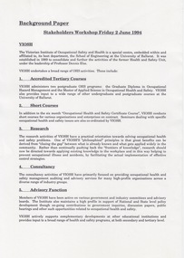
Document - Document - Information, VIOSH: Background Paper for Stakeholders Workshop, Friday 2 June 1994
Victorian Institute of Occupational Safety and Health (VIOSH) Australia is the Asia-Pacific centre for teaching and research in occupational health and safety (OHS) and is known as one of Australia's leaders on the field. VIOSH has a global reputation for its innovative approach within the field of OHS management. VIOSH had its first intake of students in 1979. At that time the Institution was known as the Ballarat College of Advanced Education. In 1990 it became known as Ballarat University College, then in 1994 as University of Ballarat. It was 2014 that it became Federation University. VIOSH Australia students are safety managers, senior advisors and experienced OHS professionals. They come from all over Australia and industry. Students are taught active research and enquiry; rather than textbook learning and a one-size fits all approach. VIOSH accepts people into the Graduate Diploma of Occupational Hazard Management who have no undergraduate degree - on the basis of extensive work experience and knowledge. The Background Paper prepared for a meeting to be held on Friday 2 May 1994. It is a Stakeholders Workshop. Information on VIOSH over the years provided. The range of OHS activities include: 1. Accredited Tertiary Courses 2. Short Courses 3. Research 4. Consultancy 5. Advisory Function 6. Information Resources The Graduate Diploma in OHM started in 1979 and was the first Occupational Health and Safety tertiary course in Australia. Since then it has continued to attract students at a national level even though similar courses were offered elsewhere. The map on Page 2 shows the extent of enrolments. The Courses Review Process is outlined and VIOSH is now able to define its own procedures and processes for reviewing its post-graduate programs.This is being managed by a small internal project management team. The "new" programs to commence in 1996.Four A4 pages, typed. Page 2 -map of Australiaviosh, victorian institute of occupational safety and health, ballarat college of advanced education, graduate diploma in ohm, stakeholders workshop, accredited tertiary courses, short courses, research, consultancy, advisory function, information resources, course review process -
Marysville & District Historical Society
Flyer (item) - Brochure, Artworkz Tourism, Marysville-Steavenson Falls, 2018
A brochure including photographs and a tourist map of Marysville and some of the area's attractions focusing on Steavenson Falls. A brochure including photographs and a tourist map of Marysville and some of the area's attractions focusing on Steavenson Falls. The Steavenson Falls is named after the Victorian Assistant Commissioner of Roads and Bridges, John Steavenson who arrived in Victoria in the early 1860s.Shadowed by over 30 Mountains and/ on the banks of the beautiful Goulburn River/ and Lake Eildon. This is our playground.marysville, steavenson falls, victoria, waterfalls, john steavenson -
 Marysville & District Historical Society
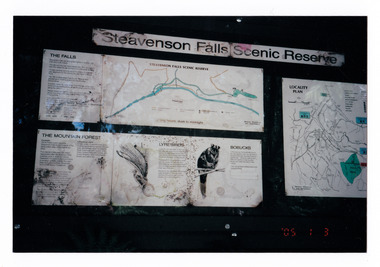
Photograph (item) - Colour photograph, 03-01-2005
Shows the sign at the Steavenson Falls Scenic Reserve.Shows the sign at the Steavenson Falls Scenic Reserve. This sign was destroyed in the 2009 Black Saturday bushfires. The Steavenson Falls is named after the Victorian Assistant Commissioner of Roads and Bridges, John Steavenson who arrived in Victoria in the early 1860s.'05 1 3 3.01.05. Marysville (from Helga Walsh)steavenson falls, steavenson falls scenic reserve, mountain forest, lyrebird, bobuck, mountain brushtail possum, marysville, victoria, john steavenson, 2009 black saturday bushfires -
 Bendigo Military Museum
photograph - Orthorectification Equipment - Army Survey Regiment, Fortuna, Bendigo, c1975
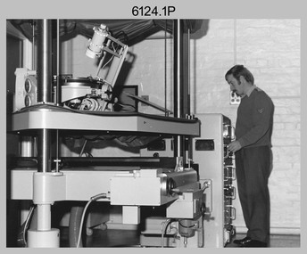
Orthophoto mapping provided the Survey Corps with the capability to produce map products quickly in the event of a crisis. These are four photographs of equipment used by the Army Survey Regiment to produce orthophotomaps. The Wild GZ1 orthophoto projector was introduced in 1973 and was the first equipment used to orthorectify colour and monochrome film aerial photography. Height profiles were originally produced on a PEB8 Stereo profiler and later were software generated. Photos of the PEB8 are available in Victorian Collections item 6222.17P, photos .5P and .6P. In the same era the IBM 1130 computer; OMI/Nistri AP/C-3 analytical plotter with coordinatograph, OP/C orthophoto projector and Zeiss Planimat D2 stereoplotters were introduced. Orthorectification is the process of removing geometric distortions and scale errors/variations from images. Images have tilt and relief distortions that make it difficult to compare accurately a map and an image of the same geographic area. Once an image is orthorectified, features on the image are shown in their planimetric locations. These four photographs of orthorectification equipment were taken at the Army Survey Regiment at Fortuna, Bendigo, c1975. Photo .1P and .3P were printed on photographic paper and scanned at 300 dpi. Photos .2P, .4P and .5P were on 35mm negative film and scanned at 96 dpi. They are part of the Army Survey Regiment’s Collection. .1) - Photo, black & white, c1975, Wild GZ1 orthophoto projector operated by CPL Phil Boyle. .2) - Photo, black & white, c1975, Wild GZ1 orthophoto projector. .3) - Photo, black & white, c1975, Wild GZ1 orthophoto projector. .4) - Photo, black & white, c1978, Zeiss D2 Planimat Stereoplotter. .5) - Photo, black & white, c1978, Zeiss D2 Planimat Stereoplotter..1P to .5P No annotations.royal australian survey corps, rasvy, army survey regiment, army svy regt, fortuna, asr -
 Bendigo Military Museum
Book - BOOK, History of the 5th Battalion AIF WWI, Albert William Keown, "Forward with the Fifth"
"Narrative of the service history of the Fifth (Victorian) Infantry Battalion 1st AIF". "A remarkable testimony of their sacrifice in the First World War".Hard cover with dust cover. Hard cover, cardboard with black coloured buckraw, red print on front and spine. Front - illustrated - silhouette drawing of soldier in uniform Back - black and white photograph of 2 soldiers on camel back. Small black over red rectangular colour patch front and back 342 pages, cut, plain, white. Illustrated black and white photographs, portraits, maps and documents.Opposite Title Page - printed donation label - "Donated by 39th Australian Infantry Battalion (1941-1943) Association Inc. www.39battalion.com"books, military, history, wwi -
 Lara RSL Sub Branch
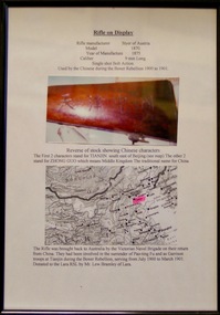
Framed Photograph and Rifle, Rifle - Styer. Made in Austria in 1875, 1875
The Boxer Rebellion, Boxer Uprising or Yihetuan Movement was a violent anti-foreign, anti-colonial and anti-Christian uprising that took place in China between 1899 and 1901, toward the end of the Qing dynasty.The Rifle was brought back to Australia by the Victorian Naval Brigade on their return from China. They had been involved in the surrender of Pao-ting Fu and as Garrison troops at Tianjin during the boxer Rebellion, serving from July 1900 to March 1901. Rifle - Styer. Made in Austria in 1875. Glass covered Rectangular Framed Photo and Map with a brief description.rifle,gun,styer rifle, boxer rebellion,lara r.s.l. -
 Bendigo Military Museum
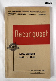
Book - BOOK, NEW GUINEA, Victorian Railways Printing Works, Reconquest, Post 1946
Reconquest. An Official Record of the Australian Army's successes .... New Guinea 1943 - 1944. Not for public sale.Soft cover, lightweight cardboard, black / beige print front & back. Red / beige background, illustrated with small Rising Sun badge. 160 pages, cut, plain, beige. Illustrated black / white photos & maps.Front cover: “Reconquest New Guinea 1943 - 1944”book, new guinea -
 Bendigo Military Museum
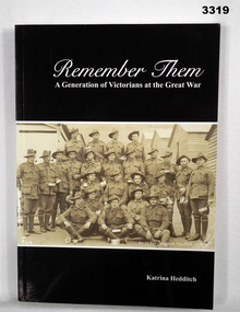
Book - BOOK, THE GREAT WAR, Remember Them, A Generation of Victorians at the Great War, 2010
Soft cardboard cover. Black & white print on front, spine & back. Black background with sepia colour photo of a group portrait of soldiers on front in foreground. Inscription front fly leaf. 192 pages, cut, plain, white. Illustrated black & white photos, maps & illustrations.Handwritten in black ink on title page front fly leaf: "To Bendigo District RSL Museum with best wishes Katrina" On title page on front fly leaf: "RSL stamp"books-military-history, great war, victorians