Showing 578 items
matching victorian rivers
-
 Kiewa Valley Historical Society
Postcard - Junction Dam - Circa 1950, Circa 1950
... resource to quench this demand. The Victorian Alps and the rivers... this demand. The Victorian Alps and the rivers flowing into its ...This postcard was produced in the 1950's for the tourist trade in the Kiewa Valley and Alpine region. It encompasses the period when the State of Victoria was pressured by the ever increasing demand by industry and its population for electricity supplies. Hydro electricity was seen as an untapped natural resource to quench this demand. The Victorian Alps and the rivers flowing into its valleys was ideal for the construction of the Kiewa Hydro Electricity Scheme. The late 1940's saw the development of this scheme and the changing of sections of alpine landscape is covered by this and other postcards/pictures (tourists, construction workers, and established rural populations). This period in time was before the established wildlife and forest/nature groups became political activist who changed legislative acts to protect the environment.This rural region (Kiewa Valley/alpine plains) was at most only significant to a smaller group of winter sports, summer hikers/horse riders and rural farmers/graziers. The numbers of tourists and the increase in the local resident population was boosted by the construction of the Hydro Electricity Scheme. This influx to the regional population resulted in a corresponding diversity in services and brought about an environment that responded to a growing level of tourists and thereby permitting this industry to grow more rapidly than it would have naturally. This postcard details an attraction to the "cleaner" method of providing electricity. This postcard was purchased in 1950 by a surveyor at Landford's Gap.This black and white photograph on a Valentine's postcard is from a V2 Argus photograph. It is on a 200g/m paper density one side gloss only/. See 0480 (A) -(L) for other photos of similar postcards."JUNCTION DAM & SPILLWAY, LAKE GUY, BOGONG, KIEWA HYDRO-ELECTRIC PROJECT" "V5" on the flip side" VALENTINE'S POST CARD " "A GENUINE PHOTOGRAPH"kiewa valley tourism, victorian alps, alternate energy supplies, alpine population growth, junction dam, secv -
 Kiewa Valley Historical Society
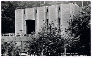
Postcard Circa 1950, No.3 Power Station Kiewa Hydro-electric Project "V.8", Circa 1950
... resource to quench this demand. The Victorian Alps and the rivers... this demand. The Victorian Alps and the rivers flowing into its ...This postcard was produced in the 1950's for the tourist trade in the Kiewa Valley and Alpine region. It encompasses the period when the State of Victoria was pressured by the ever increasing demand by industry and its population for electricity supplies. Hydro electricity was seen as an untapped natural resource to quench this demand. The Victorian Alps and the rivers flowing into its valleys was ideal for the construction of the Kiewa Hydro Electricity Scheme. The late 1940's saw the development of this scheme and the changing of sections of alpine landscape is covered by this and other postcards/pictures (tourists, construction workers, and established rural populations). This period in time was before the established wildlife and forest/nature groups became political activist who changed legislative acts to protect the environment.This rural region (Kiewa Valley/alpine plains) was at most only significant to a smaller group of winter sports, summer hikers/horse riders and rural farmers/graziers. The numbers of tourists and the increase in the local resident population was boosted by the construction of the Hydro Electricity Scheme. This influx to the regional population resulted in a corresponding diversity in services and brought about an environment that responded to a growing level of tourists and thereby permitting this industry to grow more rapidly than it would have naturally. This postcard details an attraction to the "cleaner" method of providing electricity. This postcard was purchased in 1950 by a surveyor at Landford's Gap.This black and white photograph from a Valentine's postcard is from a V2 Argus photograph postcard. It is on a 200g/m paper density photo side gloss. See 0480 (A) - (K) for other photos of similar postcards."No.3 POWER STATION KIEWA HYDRO ELECTRIC PROJECT" "V8"kiewa valley tourism, victorian alps, alternate energy supplies, alpine population growth, secv -
 Kiewa Valley Historical Society
Postcard Circa 1950, Lake Guy Dam and Bogong Village, Circa 1950
... resource to quench this demand. The Victorian Alps and the rivers... this demand. The Victorian Alps and the rivers flowing into its ...This postcard was produced in the 1950's for the tourist trade in the Kiewa Valley and Alpine region. It encompasses the period when the State of Victoria was pressured by the ever increasing demand by industry and its population for electricity supplies. Hydro electricity was seen as an untapped natural resource to quench this demand. The Victorian Alps and the rivers flowing into its valleys was ideal for the construction of the Kiewa Hydro Electricity Scheme. The late 1940's saw the development of this scheme and the changing of sections of alpine landscape is covered by this and other postcards/pictures (tourists, construction workers, and established rural populations). This period in time was before the established wildlife and forest/nature groups became political activist who changed legislative acts to protect the environment.This rural region (Kiewa Valley/alpine plains) was at most only significant to a smaller group of winter sports, summer hikers/horse riders and rural farmers/graziers. The numbers of tourists and the increase in the local resident population was boosted by the construction of the Hydro Electricity Scheme. This influx to the regional population resulted in a corresponding diversity in services and brought about an environment that responded to a growing level of tourists and thereby permitting this industry to grow more rapidly than it would have naturally. This postcard details an attraction to the "cleaner" method of providing electricity. This postcard was purchased in 1950 by a surveyor at Landford's Gap.This black and white photograph from a Valentine's postcard is from a V2 Argus photograph postcard. It is on a 200g/m paper density photo side gloss. See 0480 (B) - (F) for other photos of similar postcards.In white lettering " LAKE GUY & BOGONG VILLAGE KIEWA HYDRO-ELECTRIC PROJECT"kiewa valley tourism, victorian alps, alternate energy supplies, alpine population growth -
 Kiewa Valley Historical Society
Postcard Circa 1950, Snowfall at Bogong Village Kiewa Hydro-Electric Project, 1950s
... resource to quench this demand. The Victorian Alps and the rivers... this demand. The Victorian Alps and the rivers flowing into its ...This postcard was produced in the 1950's for the tourist trade in the Kiewa Valley and Alpine region. It encompasses the period when the State of Victoria was pressured by the ever increasing demand by industry and its population for electricity supplies. Hydro electricity was seen as an untapped natural resource to quench this demand. The Victorian Alps and the rivers flowing into its valleys was ideal for the construction of the Kiewa Hydro Electricity Scheme. The late 1940's saw the development of this scheme and the changing of sections of alpine landscape is covered by this and other postcards/pictures (tourists, construction workers, and established rural populations). This period in time was before the established wildlife and forest/nature groups became political activist who changed legislative acts to protect the environment.This rural region (Kiewa Valley/alpine plains) was at most only significant to a smaller group of winter sports, summer hikers/horse riders and rural farmers/graziers. The numbers of tourists and the increase in the local resident population was boosted by the construction of the Hydro Electricity Scheme. This influx to the regional population resulted in a corresponding diversity in services and brought about an environment that responded to a growing level of tourists and thereby permitting this industry to grow more rapidly than it would have naturally. This postcard details an attraction to the "cleaner" method of providing electricity. This postcard was purchased in 1950 by a surveyor at Landford's Gap.This scanned black and white photograph of a postcard, shows vehicles covered in thick snow at Bogong Village in 1950. See 0480(A), (C) - (F) for other similar photos of postcards available at this period."SNOWFALL AT BOGONG VILLAGE KIEWA HYDRO-ELECTRICITY PROJECT"kiewa valley tourism, victorian alps, alternate energy supplies, alpine population growth, bogong village, secv -
 Kiewa Valley Historical Society
Postcard Circa 1950, Scene in Bogong Village Kiewa Hydro-Electric Project, 1950s
... resource to quench this demand. The Victorian Alps and the rivers... this demand. The Victorian Alps and the rivers flowing into its ...This postcard was produced in the 1950's for the tourist trade in the Kiewa Valley and Alpine region. It encompasses the period when the State of Victoria was pressured by the ever increasing demand by industry and its population for electricity supplies. Hydro electricity was seen as an untapped natural resource to quench this demand. The Victorian Alps and the rivers flowing into its valleys was ideal for the construction of the Kiewa Hydro Electricity Scheme. The late 1940's saw the development of this scheme and the changing of sections of alpine landscape is covered by this and other postcards/pictures (tourists, construction workers, and established rural populations). This period in time was before the established wildlife and forest/nature groups became political activist who changed legislative acts to protect the environment. This rural region (Kiewa Valley/alpine plains) was at most only significant to a smaller group of winter sports, summer hikers/horse riders and rural farmers/graziers. The numbers of tourists and the increase in the local resident population was boosted by the construction of the Hydro Electricity Scheme. This influx to the regional population resulted in a corresponding diversity in services and brought about an environment that responded to a growing level of tourists and thereby permitting this industry to grow more rapidly than it would have naturally. This postcard details an attraction to the "cleaner" method of providing electricity. This postcard was purchased in 1950 by a surveyor at Landford's Gap. The couple shown in this photograph would have been employed by the S.E.C. under the Kiewa Hydro-Electricity Scheme.This item is a scanned black and white photograph of a couple walking along a gravel street in Bogong Village in 1950. See 0480 (A) ,(B), (D) - (F) for other photos of similar postcards" SCENE IN BOGONG VILLAGE KIEWA HYDRO-ELECTRIC PROJECT"kiewa valley tourism, victorian alps, alternate energy supplies, alpine population growth, bogong, secv -
 Kiewa Valley Historical Society
Postcard Circa 1950, Howman Gap Hostel under snow Kiewa Hydro-Electric Project, Circa 1950
... resource to quench this demand. The Victorian Alps and the rivers... this demand. The Victorian Alps and the rivers flowing into its ...This postcard was produced in the 1950's for the tourist trade in the Kiewa Valley and Alpine region. It encompasses the period when the State of Victoria was pressured by the ever increasing demand by industry and its population for electricity supplies. Hydro electricity was seen as an untapped natural resource to quench this demand. The Victorian Alps and the rivers flowing into its valleys was ideal for the construction of the Kiewa Hydro Electricity Scheme. The late 1940's saw the development of this scheme and the changing of sections of alpine landscape is covered by this and other postcards/pictures (tourists, construction workers, and established rural populations). This period in time was before the established wildlife and forest/nature groups became political activist who changed legislative acts to protect the environment.This rural region (Kiewa Valley/alpine plains) was at most only significant to a smaller group of winter sports, summer hikers/horse riders and rural farmers/graziers. The numbers of tourists and the increase in the local resident population was boosted by the construction of the Hydro Electricity Scheme. This influx to the regional population resulted in a corresponding diversity in services and brought about an environment that responded to a growing level of tourists and thereby permitting this industry to grow more rapidly than it would have naturally. This postcard details an attraction to the "cleaner" method of providing electricity. This postcard was purchased in 1950 by a surveyor at Landford's Gap.This item is a scanned black and white photograph of a panoramic view of Howman Gap Hostel under snow in 1950 (a closed village, entry by pass only). This accommodation was for construction workers only. See 0480 (A) -(E) for other photos of similar postcards.On the photo, " Howman Gap Hostel under snow Kiewa Hydro-Electric Project" . On postcard address and personal information side "V.2 Valentine's Post Card "kiewa valley tourism, victorian alps, alternate energy supplies, alpine population growth, bogong, secv, howman's gap hostel -
 Kiewa Valley Historical Society
Postcard Circa 1950, Mt. Beauty Village, Kiewa Hydro-Electricity Project, circa 1950
... resource to quench this demand. The Victorian Alps and the rivers... this demand. The Victorian Alps and the rivers flowing into its ...This postcard was produced in the 1950's for the tourist trade in the Kiewa Valley and Alpine region. It encompasses the period when the State of Victoria was pressured by the ever increasing demand by industry and its population for electricity supplies. Hydro electricity was seen as an untapped natural resource to quench this demand. The Victorian Alps and the rivers flowing into its valleys was ideal for the construction of the Kiewa Hydro Electricity Scheme. The late 1940's saw the development of this scheme and the changing of sections of alpine landscape is covered by this and other postcards/pictures (tourists, construction workers, and established rural populations). This period in time was before the established wildlife and forest/nature groups became political activist who changed legislative acts to protect the environment. The regulatory pondage on the northern aspect of the village had no water over-spill from the unfinished power station.This rural region in 1950 (Kiewa Valley/alpine plains) was at most only significant to a smaller group of winter sports, summer hikers/horse riders and rural farmers/graziers. The numbers of tourists and the increase in the local resident population was boosted by the construction of the Hydro Electricity Scheme. This influx to the regional population resulted in a corresponding diversity in services and brought about an environment that responded to a growing level of tourists and thereby permitting this industry to grow more rapidly than it would have naturally. This postcard details an attraction to the "cleaner" method of providing electricity. This postcard was purchased in 1950 by a surveyor at Landford's Gap. The couple shown in this photograph would have been employed by the S.E.C. under the Kiewa Hydro-Electricity Scheme.This item is a scanned black and white photograph of a panoramic view of Mount Beauty Village in 1950 (a closed village, entry by pass only). The regulatory pondage has earthen walls but no water.See 0480 (A) -(D) and (F) for other photos of similar postcards"MT. BEAUTY VILLAGE KIEWA HYDRO-ELECTRIC PROJECT"kiewa valley tourism, victorian alps, alternate energy supplies, alpine population growth -
 Kiewa Valley Historical Society
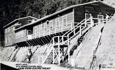
Postcard Circa 1950, Men's Mess No.4 Power Station, Kiewa Hydro-Electric Project
... resource to quench this demand. The Victorian Alps and the rivers... this demand. The Victorian Alps and the rivers flowing into its ...This postcard was produced in the 1950's for the tourist trade in the Kiewa Valley and Alpine region. It encompasses the period when the State of Victoria was pressured by the ever increasing demand by industry and its population for electricity supplies. Hydro electricity was seen as an untapped natural resource to quench this demand. The Victorian Alps and the rivers flowing into its valleys was ideal for the construction of the Kiewa Hydro Electricity Scheme. The late 1940's saw the development of this scheme and the changing of sections of alpine landscape is covered by this and other postcards/pictures (tourists, construction workers, and established rural populations). This period in time was before the established wildlife and forest/nature groups became political activist who changed legislative acts to protect the environment.Although this photo details the eating facilities of the construction workers at the power station it was not only a postcard for the people employed in the Hydro Scheme is was also provided to tourists visiting the area and thus used for promotional purposes.This rural region (Kiewa Valley/alpine plains) was at most only significant to a smaller group of winter sports, summer hikers/horse riders and rural farmers/graziers. The numbers of tourists and the increase in the local resident population was boosted by the construction of the Hydro Electricity Scheme. This influx to the regional population resulted in a corresponding diversity in services and brought about an environment that responded to a growing level of tourists and thereby permitting this industry to grow more rapidly than it would have naturally. This postcard details an attraction to the "cleaner" method of providing electricity. This postcard was purchased in 1950 by a surveyor at Landford's Gap. The men shown in this photograph would have been employed by the S.E.C. under the Kiewa Hydro-Electricity Scheme.This item is a scanned black and white photograph of a construction worker walking from stairs leading down from the men's mess building, in 1950. See 0480 (A) -(C), (E) - (F) for other photos of similar postcards"MEN'S MESS No.4 POWER STATION AREA, KIEWA HYDRO-ELECTRIC PROJECT" "ARGUS PHOTO V.IIkiewa valley tourism, victorian alps, alternate energy supplies, alpine population growth, secv -
 Wodonga & District Historical Society Inc
Album - Hume Reservoir Australia Album - View from the Victorian bank of the Murray River, May 1923
... DEPARTMENT OF PUBLIC WORKS, N.S.W. RIVER MURRAY WATERS.... 12. View from the Victorian bank of the river showing ...This set of photos is from a leather bound album bearing the inscription "HUME RESERVOIR AUSTRALIA" plus 'The Rt. Hon. L. C. M. S. Amery, P. C., M .P.' all inscribed in gold. It was presented to The Rt. Hon. L. C. M. S. Amery, P. C., M. P, Secretary of State for Dominion Affairs on the occasion of his visit to the Hume Reservoir on 2nd November 1927. This album is of local and national significance as it documents the planning and development of the Hume Reservoir up to 1927. It was the largest water reservoir in the British Empire. The album records the pioneering engineering work that went into its construction.DEPARTMENT OF PUBLIC WORKS, N.S.W. RIVER MURRAY WATERS SCHEME. HUME RESERVOIR. 12. View from the Victorian bank of the river showing in the foreground a levee bank along the New South Wales side of the river with connecting wings back to the higher ground, May 1923. The first stage in the construction of the Dam foundations was carried out inside the levee bank which was at a sufficient height to protect from floods the work going on inside. A length of 300 feet of the Dam was left at a low elevation to allow of the river flowing over it in the second stage of the operations and at the ends of the concrete was brought up above flood level. To divert the river, a Coffer Dam was built across the old bed above and below the Dam site and tying into the end of the concrete wall built inside the levee bank. This completely surrounded the remainder of the site of the Dam and south wing wall, including an area of 12½ acres.hume reservoir australia, river murray waters scheme, hume reservoir construction -
 The Beechworth Burke Museum
Photograph, 1997
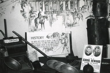
This photograph is recorded as having been taken in the North East Victoria Regional Tourist Authority, Wangaratta and depicts an exhibition display of items and interpretative labels associated with the Kelly Gang. The display was reportedly laid out as part of a Vic Tour Stamp, with items from the Burke Museum Collection.This photograph is of social significance due to its connection with the Burke Museum as well as the Kelly Gang. The Kelly Gang story is integral to the formation of the Australian identity and highlights the Irish oppression during the 1880s. Ned Kelly is an Australian icon, mythologised in Australian literature, art, folklore and history, and the Kelly Gang permeates Australia's national consciousness. The significance of the Burke Museum is also highlighted here, as the photograph shows the importance of the Kelly story to the Beechworth area and local identity, as well as its significance within the museum collection. The photograph is of strong research potential due to its depiction of the Kelly Gang history in Australia and its presentation of a historical museum exhibition which toured from Beechworth to other Victorian locations. With a depiction of the exhibition and associated label, the photograph provides insight into how the language and historical interpretation of Kelly Gang has developed, and how cultural and social opinions which are often shaped by exhibition displays, have shifted. Black and white rectangular photograph printed on matte photographic paper.Obverse: Gold Cradle / History / Claim 1835 / The north east is rich in history. It was the home of Ned Kelly, the 'Man from Snowy River' and (???) dog Mogan. Century old buildings are common and (???)nders of the gold rush days are everywhere / V. R. / £8000 Reward / Robbery and Murder / (indeterminate) Reverse: The historical display laid out in VICTOUR / 1997 3135 / North East Victoria/ Regional Tourist Authority/ P.O. Box 250/ Wangaratta. 3577 /BMMA03324burke museum, ned kelly, kelly gang, museum collection, exhibition, display, gallery, museum, exhibit -
 The Beechworth Burke Museum
Photograph, Unknown c.1930s
This image shows Bethanga Bridge, which was constructed between 1927 and 1930 in Albury, NSW. The bridge was a necessity due to the building of the Hume Dam (Wier), 1919-1936. Bethanga Bridge is a long, nine-span, riveted-steel, variable depth, Pratt Truss road bridge of nine principal spans of 82 metres and a total length of 752 metres over the flooded valley of the Murray River, now part of Hume Reservoir. Because of its unique location, over the waters of a dam with the border running down the centre of the body of water, the Bethanga bridge is the only built structure shared by both New South Wales and Victoria. It was built 1.6 kilometres upstream of the dam and in 1961 was raised 300mm, with a concrete deck replacing the original wooden deck. The State Rivers and Water Supply Commission of Victoria and the New South Wales Department of Public Works were responsible for the construction works for the Hume Weir under the River Murray Waters Agreement. It is apparent that a similar joint arrangement was made for the construction of the Bethanga Bridge as part of the Hume Weir works.This photograph of the Bethanga Bridge is of historical significance as it showcases the architectural skills of Percy Allen and Vincent Packer. Additionally, it reveals the environmental landscape of the 1920s-1930s, is linked to the Hume Dam and both New South Wales and Victorian heritage. Unmounted black and white rectangular photograph. Reverse: 1997.3196 84-20-3bethanga, bethanga bridge, hume dam, pratt truss, murray river, hume weir, transportation -
 The Beechworth Burke Museum
Photograph, c. 1927 - 1930
Taken during the construction of the Bethanga Bridge (1927-1930), this sepia photograph shows a view of the incomplete bridge taken from inside the structure and looking down the span of the bridge from where the photographer stands. The photograph depicts an incomplete deck, with loose-looking wooden planks/panels lain along the centre in groups of three. Once complete, the original decking of the bridge was made of timber before being replaced by cement in 1961 (Victorian Heritage Database).Bethanga Bridge is of historical significance to the Indigo Shire for its associations with the construction of Hume Dam, its associations with the River Murray Waters Agreement and the River Murray Commission, and illustration of the needs and influence of the farming communities along the river in this area - particularly in relation to the building of the Weir. It also represents the collaboration between New South Wales and Victoria on a large infrastructure project, being the only built structure shared by both New South Wales and Victoria due to its location. also reflecting on the Shire's geographical closeness to this neighboring state. This photograph is part of a series that documents the construction of this well-known heritage site of significance to the Indigo Shire. It reflects upon a period of growth and change in the area.Sepia, rectangular photograph printed on matt photographic paper, unmountedReverse: 1997.3190 / Another snap of the bridge. taken on the bridge showing huge steel sides / 84-19-4 / V [in circle] 354 / KODAK PRINTbethanga bridge, hume dam, bridges album, construction, road construction, hume weir -
 The Beechworth Burke Museum
Audio - Oral History, Jennifer Williams, Mrs Vanessa McDonald, 9 November 2000
Mrs. Vanessa McDonald was born in Beechworth in 1917. Christened, Agnes Bertha Collins, Vanessa changed her name in 1960. Mrs. McDonald's family's connection with gold mining in the district reach back to the first of Beechworth's gold rushes, when her great grandfather, a Dutchman who adopted the name Charles Collins, arrived in 1851-1852. Mrs. McDonald spent her childhood in the isolated hamlet of Stanley, in the area known as 'Little Scotland', where she recalls helping her mother to raise younger siblings, picking apples and walnuts on the family farm, and roaming the hills for wildflowers. As a young woman Mrs. McDonald attended religious and social gatherings in the local community. In 1940 she went to Melbourne to work as a mothercraft nurse during the Second World War. She met her husband at a Beechworth football match and was married at the Stanley Methodist Church in 1941. The gold diggings known as the 'Nine Mile' became the hamlet of Stanley, after the British Prime Minister, Lord Stanley, in 1858. By the late 1850s, Stanley boasted schools, an athenaeum, a church, a weekly newspaper and several hotels and other civic infrastructure to cater for a growing population. The area attracted large numbers of Chinese miners, whose presence was frequently resisted. Like other early Victorian mining settlements, Stanley was a hotbed of political and racial tensions during the gold rush. One side of the Nine Mile Creek was known as 'Little Scotland’, the other, 'Little Ireland'. A number of Christian denominations built congregations and churches in Stanley, including the Church of England, Methodist Church, the Catholic Church, and Presbyterian Church. Stanley became part of the United Shire of Beechworth in 1871. By 1880 timber was being cut and two sawmills were established by 1887. River-dredged gold mining consumed vast amounts of timber from the forests in the area, and in 1931 the first of several softwood plantations began. This oral history recording was part of a project conducted by Jennifer Williams in the year 2000 to capture the everyday life and struggles in Beechworth during the twentieth century. This project involved recording seventy oral histories on cassette tapes of local Beechworth residents which were then published in a book titled: 'Listen to what they say: voices of twentieth century Beechworth'. These cassette tapes were digitised in July 2021 with funds made available by the Friends of the Burke.Following the decline in the mining and associated industries during the early-mid-twentieth century, the Beechworth district experienced a period of general economic decline. On the east side of the Dingle Range, Mrs. McDonald's father, William Henry Collins, felled timber and the family were pioneer apple orchardists. The establishment of apple orchards in Stanley reflects changes to how land was used and contributes to our understanding of the historical development of rural communities following the gold rush. Mrs. McDonald's recollections are significant for understanding family and social life in a small rural town in years leading up to the Great Depression and prior to the Second World War. This oral history recording may be compared with other oral histories and items in the Burke Museum's collection. This oral history account is socially and historically significant as it is a part of a broader collection of interviews conducted by Jennifer Williams which were published in the book 'Listen to what they say: voices of twentieth-century Beechworth.' While the township of Beechworth is known for its history as a gold rush town, these accounts provide a unique insight into the day-to-day life of the town's residents during the 20th century, many of which will have now been lost if they had not been preserved.This is a digital copy of a recording that was originally captured on a cassette tape. The cassette tape is black with a horizontal white strip and is currently stored in a clear flat plastic rectangular container. It holds up 40 minutes of recordings on each side.Mrs Vanessa McDonald /listen to what they say, beechworth, oral history, burke museum, emigration, gold rush immigration, victorian gold rush, mining families, apple orchard, forestry, forest plantation, little scotland, stanley, twentieth century history, regional australia, rural australia, farming, harvest festival, great depression, dingle range, the nine mile, australian wildflowers, high country wildflowers, mothercraft nurse, rural and regional women, social history, collins, mrs. vanessa mcdonald, building community life, shaping cultural and creative life, fruit growers, family history, changes to land use in regional victoria -
 Orbost & District Historical Society
book, Enterprise Press Pty Ltd, Dargo Crooked River, C 1994-1997
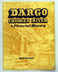
This is a pictorial history of the Crooked River district.This is a useful reference tool on the history of gold mining in the Dargo area.A thin 56 pp paperback book titled,"Dargo Crooked River a Pictorial History". On the yellow front cover is a sepia photograph of a man standing outside a rough wooden hut. The title and author are printed in black text over this. The book contains Black / white photographs and the history of Dargo and Crooked River. The information is divided int decades. Inside there is a newspaper cutting of Victorian cattlemen on Junction Plain near Omeo.dargo-crooked-river gold-mining east-gippsland-history -
 Orbost & District Historical Society
book, Snowy Water Inquiry, Snowy Water Inquiry Final Report, 1998
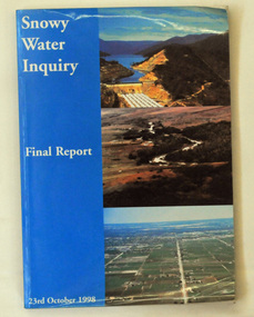
The Snowy Water Inquiry was commissioned in 1998 with a brief to recommend environmental water release options to the Commonwealth, Victorian, and NSW Governments so that corporatisation of the Snowy Mountains Scheme could proceed. These release options related to the Snowy River below Jindabyne, the Murray River and other rivers associated with the Scheme. The Inquiry objectives were that the recommendations would not adversely impact on water supplies to existing irrigators or the viability of the Snowy Mountains Scheme. (ref snowyhydro.com.au)This report contains information about water allocation and uses of the Snowy River.A book of 160 pp - Snowy River Inquiry Final report 23rd October 1998. Submitted to the Governments of New South Wales and Victoria / Commissioner: The Hon. Robert Webster. On the front cover are three aerial photographs of the Snowy River and Snowy Hydro Scheme. The book contains maps and photographs. snowy-river snowy-hydro snowy-mountains government-inquiry -
 Orbost & District Historical Society
postcard, C1920-1940
This photograph shows the second major bridge across the Snowy River at Orbost. The current Snowy River bridge is the fourth to provide a crossing to the township of Orbost. The first, in 1891, lasted just two years before it succumbed to flood waters. The bridge in this photograph was built in the 1920s as a road and rail bridge, and was again partly washed away by flood waters in 1934. After the end of the first World War the Victorian Railways considered an extension of the railhead across the river at Orbost, and in 1922 a new timber and steel girder structure, a joint Country Roads Board — Victorian Railways venture, was built and completed at a cost of £41,000 (the steel girders came from the Flinders Street viaduct reconstruction). Subsequently it was decided not to take the railway across the river, and the bridge was only used by road traffic. It was severely battered by floods during its life. and after the 1971 floods was eventually replaced by the current bridge in 1975. (info from Newletter 54N by John Phillips) This item is an early pictorial record of the previous Snowy River bridge at Orbost.A postcard with a black / white photograph of a bridge - timber and steel girder structure - across the Snowy River at Orbost, Reflections of the bridge are seen in the water.snowy-river-bridge-orbost -
 Orbost & District Historical Society
black and white photograph, late 19th century
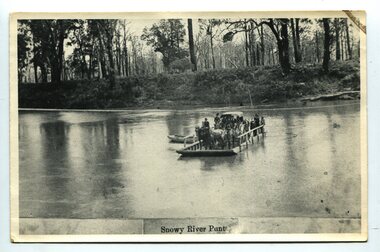
A punt crossed the Snowy River at Orbost from 1884. A bridge was constructed in 1893, but was soon damaged by a huge flood. Flooding was a regular occurrence, the worst inundations being in 1870, 1893, 1925, 1934, 1952 and 1971. Over the years major flood protection works have been implemented. The Princes Highway, which passes Orbost, now crosses the flood plain on raised concrete supports. (info, from Victorian Places Orbost)This item is associated with the Snowy River and its history. It is a pictorial record of transport in the late 19th century.A black / white photograph (copy) of a punt loaded with people and a horse-drawn carriage making its way across a river.on front at bottom - "Snowy River Punt"snowy-river-orbost transport shipping -
 Orbost & District Historical Society
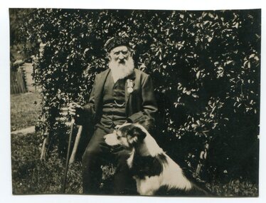
black and white photograph, early 20th century
This is a photograph of Samuel Smith, aged 92, with his dog outside his home, Gloucester House, near Cann River. He was the keeper at CapeEverard (Point Hicks) for five years.He retired from the lighthouse position in 1904. His life story was written in The Snowy River Mail, Orbost, Wednesday Evening – 27 January 1937 as "LIFE STORY OF SAMUEL SMITH". He was born in Gloucestershire in 1844 and died in 1937 at the the Orbost Hospital. There was an obituary in The Argus (Melbourne) on Saturday 18 February, 1939. Samuel Smith, of Noorinbee, East Gippsland, was the last survivor of the original crew of the frigate Victoria, the first vessel of the old Victorian Navy. When the Victoria arrived in Melbourne in 1861 after having landed soldiers in New Zealand for the Maori War, the crew was given a civil reception, and each member was presented with a sovereign in honor of the birth of the Victorian Navy. A black / white photograph of a bearded elderly man sitting and holding a cane. A dog is sitting at his knee. The photograph has ben taken outside in a garden.on back - "Samuel Smith, Head Lighthouse Keeper at C. Everard, retired 1904"cape-everard point-hicks smith-samuel -
 Orbost & District Historical Society
black and white photographs, Howard D. Bulmer, first half 20th century
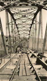
This bridge was built in the 1920s as a road and rail bridge, and was partly washed away by flood waters in 1934. After the end of the first World War the Victorian Railways considered an extension of the railhead across the river at Orbost, and in 1922 a new timber and steel girder structure, a joint Country Roads Board — Victorian Railways venture, was built and completed at a cost of £41,000 (the steel girders came from the Flinders Street viaduct reconstruction). Subsequently it was decided not to take the railway across the river, and the bridge has only been used by road traffic. This is a pictorial record of an early bridge across the Snowy River at Orbost.A large black / white photograph of the Orbost Snowy River bridge. There is a large copy as well as a postcard copy in sepia.on front - Snowy River Bridge Orbost H.D. Bulmer - photo - Lake Tyers.snowy-river-bridge-orbost -
 Orbost & District Historical Society
black and white photograph, July 1922
A new bridge over the Snowy River at Orbost was opened for traffic on June 20th 1922. It was designed for future joint use by road and railway traffic, but it was only used for road traffic. During the last few years the condition of an old suspension bridge [the 1893 bridge] which was the only vehicular crossing between the town of Orbost and the railway station, caused much concern. The structure was of timber, except for the wire suspension cables of its central span of about 100 feet. A design was prepared in 1914 for a permanent bridge with five spans of 85 feet composed of plate girders on concrete piers. With great increase in the price of steel work during the war, the cost of this design became prohibitive, and the need for a new structure becoming urgent, alternative proposals were investigated. As a result the present design was adopted as providing a sem-permanent bridge at moderate cost. The new bridge spans the river about 160 feet upstream from the old bridge on a slight skew, the piers being at an angle of 80 degrees with the centre line of the bridge. It has a camber of about 2 feet 5 inches in its total length of 527 feet. ( information from Newsletter March 2014 - Lois Crisp) The photograph shows Mrs James Cameron cutting the ribbon at the opening of the Orbost Pile Bridge in 1922. This second bridge, was built by the Victorian Railways and the Country Roads Board. Constructed at a cost of 35,000 pounds and used second-hand girders from the Flinders Street- Spencer Street viaduct. On July 4 1922 it was officially opened by Mrs James Cameron. Unfortunately, her husband, who had long championed the building of the bridge so that it would be ready for the railway to continue to the border, was too ill to attend the ceremony. In fact, James Cameron died on July 13 after a long and severe illness (ref. S.R.M. 20.7.1922). There is a section of this ribbon in the collection - Registration No. 366. This is a pictorial record of a significant event in Orbost's history.A black / white photograph of a pile bridge with a suspension bridge behind it. There are many people standing on the bridge.on back - "Opening of Pile Bridge - 1922"snowy-river-bridge ceremonies cameron-mrs -
 Orbost & District Historical Society
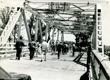
black and white photograph, 1976
This bridge over the Snowy River was opened on July 4 1922. It was constructed in 1922 alongside the previous suspension bridge. Its building was a combined effort of the Victorian Railways and the Country Roads Board at a cost of 35,000 pounds. It was replaced in 1976 by the present bridge after several major floods. This photograph shows people walking over the bridge for the last time.This is a pictorial record of the former Snowy River Bridge at Orbost.A black / white photograph showing a group of people walking across a bridge. There are several cars, a man on a horse and people standing on the side of the roadway.on back - "1976 - old bridge"snowy-river-bridge-1976 -
 Orbost & District Historical Society
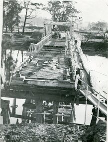
black and white photograph, 1971
This photograph shows the second major bridge across the Snowy River at Orbost. The current Snowy River bridge is the fourth to provide a crossing to the township of Orbost. The first, in 1891, lasted just two years before it succumbed to flood waters. The bridge in this photograph was built in the 1920s as a road and rail bridge, and was again partly washed away by flood waters in 1934. After the end of the first World War the Victorian Railways considered an extension of the railhead across the river at Orbost, and in 1922 a new timber and steel girder structure, a joint Country Roads Board — Victorian Railways venture, was built and completed at a cost of £41,000 (the steel girders came from the Flinders Street viaduct reconstruction). Subsequently it was decided not to take the railway across the river, and the bridge was only used by road traffic. It was severely battered by floods during its life. and after the devastating 1971 floods was eventually replaced by the current bridge in 1975. (info from Newletter 54N by John Phillips)This is a pictorial record of the flood damage in 1971 when part of the Snowy River Bridge was washed away.A black / white photograph of a bridge which has been damaged by floodwaters. It shows one end has been washed away.orbost-snowy-river-bridge-1971 floods-orbost-1971 -
 Orbost & District Historical Society
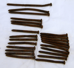
bridge spikes, 1922
These spikes are from the old Snowy River bridge (the second) constructed in 1922 alongside the previous suspension bridge. Its building was a combined effort of the Victorian Railways and the Country Roads Board at a cost of 35,000 pounds. It was replaced in 1976 by the present bridge after several major floods.These items are from a significant piece of infrastructure built in Orbost in the early 20th century. This bridge no longer exists.Twenty-four iron spikes of four different lengths. They are probably hand-made and have round shafts and heads. They are very rusty.snowy-river-bridge bridge-spikes bridge orbost -
 Flagstaff Hill Maritime Museum and Village
Photograph
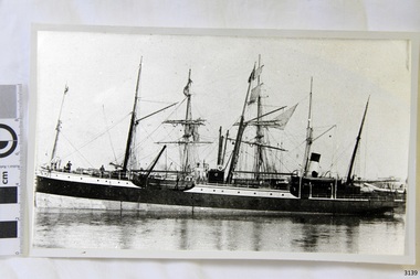
Black and White photograph of vessel S.S. Casino in calm water, taken 1882-1932. The coastal trader has light rigging and steam funnel, lifeboat on side, two men on deck. Background shows other ships. The S.S. Casino was a passenger and freight steamer built in Dundee, Scotland, in 1882 for the Newcastle and Hunter River Steam Navigation Company of N.S.W. She weighed 425 tons gross with a length of 160.4 feet, beam of 24.1 feet and depth of 10.2 feet. She had saloon accommodation for 35 people, forecabin for 25 more people, and she carried 300 tons of cargo. While on her delivery journey on May 30th 1882 the S.S. Casino called in at the Port of Warrnambool for coal ., narrowly escaping going ashore in gale force winds due to the quick action of the pilot. At that time, still at anchor, she impressed the directors of the Belfast and Koroit Steam Navigation Company so much that they bought her immediately; she was ideal for trade in along the West Coast of Victoria. (Belfast is the original name for Port Fairy, South West Victoria. The Belfast and Koroit Steam Navigation Company was first managed by Messers. Saltau and Osburne and after the passing of Mr. Osburne, by produce merchants Messers H. Sautau and Sons, whose had a hay and corn store and shipping agency was on the corner of Liebig and Koroit Streets in Warrnambool. ) The S.S. Casino became “the most famous steamer to operate in Victorian waters along the West Coast” by author Jack Loney. Captain Boyd was her first Master, followed by Captain Chapman, who stayed with her 1890 until 1924. Captain W. Robertson followed for a short term, then Captain Middleton then took command 1925 - 1932. The S.S. Casino had several mishaps during her life. One was on 3rd January 1898 when she collided with the S.S. Flinders in Apollo Bay with minor damage. Another was on 24th October 1924 when she grounded on a reef at Point Hawdon near Grey River and most of her cargo (of Christmas goods) had to be dumped into the sea. Then in February 1929 she was ‘holed’ when she struck a submerged object as she entered Lady Bay, Warrnambool. On the morning of 10th July 1932, after attempting to berth at Apollo Bay jetty in heavy seas, Captain Middleton decided to take her out into the bay and wait until the seas abated. It was not realised that the anchor used to steady her as she manoeuvred to her berth had pierced her hull. She put about and headed for the beach but sank. Captain Middleton and nine others lost their lives; nine people were rescued including the two female passengers . Captain Middleton had been in charge of the S.S. Casino for seven years. He was the first ship’s Master to lose his life through shipwreck in the West Coast trade. In the years following the turn of the century the S.S. Casino remained the only regular trader with normal passenger accommodation along the West Coast. From 1882 she had made at least 2,500 voyages on the one run. Flagstaff Hill’s collection has a photograph of a portrait of Captain Chapman, , a ship model of the S.S. Casino that shows both forms of power under which she sailed, steam and sail. The ship is painted green and flies three flags. The inscription across the case of the ship model, incorrectly dated, tells the sad story of the wreck of the ship and the loss of lives on July 10th 1932 at Apollo Bay. A print in the Collection show S.S. Casino underway in heavy sea off Point Lonsdale, another two photographs show her at the Port of Warrnambool, leaving from the Breakwater in Lady Bay and another identifies the S.S. Casino as a ship from the Belfast and Koroit Steam Navigation Company. (Belfast is the original name for the township of Port Fairy). This photograph was taken 1882-1932. It is significant because of its association with the coastal trader S.S. Casino and its significance to trade along Victoria's West Coast in the late 19th and early 20th century. The wreck of the S.S. Casino is considered an important part of Victorian and Australian cultural heritage and as such has been declared and protected as an Historic Shipwreck under State and Commonwealth Law in the Commonwealth Historic Shipwrecks Act (1976). Black and White photograph of vessel S.S. Casino in calm water, taken 1882-1932. The coastal trader has light rigging and steam funnel, lifeboat on side, two men on deck. Background shows other ships.flagstaff hill, warrnambool, shipwrecked coast, flagstaff hill maritime museum, maritime museum, shipwreck coast, flagstaff hill maritime village, great ocean road, newcastle and hunter river steam navigation company, belfast and koroit steam navigation company, h. sautau and sons, s.s. casino, west coast trader s.s. casino, victorian coastal trader, captain boyd, captain w. robertson, captain chapman, captain middleton, apollo bay shipwreck, s.s. casino at lady bay warrnambool, saltau and osburne -
 Flagstaff Hill Maritime Museum and Village
Photograph
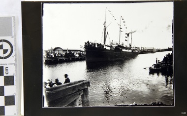
Black and White Photograph of S.S Casino arriving in port, taken 1930-1932. Decks are laden with men and women , crowd of waving people along the river bank, smoke coming from funnel. Warehouse and homes in the background. The S.S. Casino was a passenger and freight steamer built in Dundee, Scotland, in 1882 for the Newcastle and Hunter River Steam Navigation Company of N.S.W. She weighed 425 tons gross with a length of 160.4 feet, beam of 24.1 feet and depth of 10.2 feet. She had saloon accommodation for 35 people, forecabin for 25 more people, and she carried 300 tons of cargo. While on her delivery journey on May 30th 1882 the S.S. Casino called in at the Port of Warrnambool for coal ., narrowly escaping going ashore in gale force winds due to the quick action of the pilot. At that time, still at anchor, she impressed the directors of the Belfast and Koroit Steam Navigation Company so much that they bought her immediately; she was ideal for trade in along the West Coast of Victoria. (Belfast is the original name for Port Fairy, South West Victoria. The Belfast and Koroit Steam Navigation Company was first managed by Messers. Saltau and Osburne and after the passing of Mr. Osburne, by produce merchants Messers H. Sautau and Sons, whose had a hay and corn store and shipping agency was on the corner of Liebig and Koroit Streets in Warrnambool. ) The S.S. Casino became “the most famous steamer to operate in Victorian waters along the West Coast” by author Jack Loney. Captain Boyd was her first Master, followed by Captain Chapman, who stayed with her 1890 until 1924. Captain W. Robertson followed for a short term, then Captain Middleton then took command 1925 - 1932. The S.S. Casino had several mishaps during her life. One was on 3rd January 1898 when she collided with the S.S. Flinders in Apollo Bay with minor damage. Another was on 24th October 1924 when she grounded on a reef at Point Hawdon near Grey River and most of her cargo (of Christmas goods) had to be dumped into the sea. Then in February 1929 she was ‘holed’ when she struck a submerged object as she entered Lady Bay, Warrnambool. On the morning of 10th July 1932, after attempting to berth at Apollo Bay jetty in heavy seas, Captain Middleton decided to take her out into the bay and wait until the seas abated. It was not realised that the anchor used to steady her as she manoeuvred to her berth had pierced her hull. She put about and headed for the beach but sank. Captain Middleton and nine others lost their lives; nine people were rescued including the two female passengers . Captain Middleton had been in charge of the S.S. Casino for seven years. He was the first ship’s Master to lose his life through shipwreck in the West Coast trade. In the years following the turn of the century the S.S. Casino remained the only regular trader with normal passenger accommodation along the West Coast. From 1882 she had made at least 2,500 voyages on the one run. Flagstaff Hill’s collection has a photograph of a portrait of Captain Chapman, , a ship model of the S.S. Casino that shows both forms of power under which she sailed, steam and sail. The ship is painted green and flies three flags. The inscription across the case of the ship model, incorrectly dated, tells the sad story of the wreck of the ship and the loss of lives on July 10th 1932 at Apollo Bay. A print in the Collection show S.S. Casino underway in heavy sea off Point Lonsdale, another two photographs show her at the Port of Warrnambool, leaving from the Breakwater in Lady Bay and another identifies the S.S. Casino as a ship from the Belfast and Koroit Steam Navigation Company. (Belfast is the original name for the township of Port Fairy). This photograph is significant because of its association with the coastal trader S.S. Casino 1882-1932 and its significance to trade along Victoria's West Coast in the late 19th and early 20th century. The wreck of the S.S. Casino is considered an important part of Victorian and Australian cultural heritage and as such has been declared and protected as an Historic Shipwreck under State and Commonwealth Law in the Commonwealth Historic Shipwrecks Act (1976). Black and White Photograph of S.S Casino arriving in port, taken 1930-1932. Decks are laden with men and women , crowd of waving people along the river bank, smoke coming from funnel. Warehouse and homes in the background. flagstaff hill, warrnambool, shipwrecked coast, flagstaff hill maritime museum, maritime museum, shipwreck coast, flagstaff hill maritime village, great ocean road, newcastle and hunter river steam navigation company, belfast and koroit steam navigation company, h. sautau and sons, s.s. casino, west coast trader s.s. casino, victorian coastal trader, captain boyd, captain w. robertson, captain chapman, captain middleton, apollo bay shipwreck, s.s. casino at lady bay warrnambool, saltau and osburne -
 Flagstaff Hill Maritime Museum and Village
Photograph
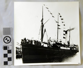
Black and White Photograph of S.S Casino arriving in Port. Taken 1930-1932. People on the deck and on the river banks waving. Smoke coming from funnel. The S.S. Casino was a passenger and freight steamer built in Dundee, Scotland, in 1882 for the Newcastle and Hunter River Steam Navigation Company of N.S.W. She weighed 425 tons gross with a length of 160.4 feet, beam of 24.1 feet and depth of 10.2 feet. She had saloon accommodation for 35 people, forecabin for 25 more people, and she carried 300 tons of cargo. While on her delivery journey on May 30th 1882 the S.S. Casino called in at the Port of Warrnambool for coal ., narrowly escaping going ashore in gale force winds due to the quick action of the pilot. At that time, still at anchor, she impressed the directors of the Belfast and Koroit Steam Navigation Company so much that they bought her immediately; she was ideal for trade in along the West Coast of Victoria. (Belfast is the original name for Port Fairy, South West Victoria. The Belfast and Koroit Steam Navigation Company was first managed by Messers. Saltau and Osburne and after the passing of Mr. Osburne, by produce merchants Messers H. Sautau and Sons, whose had a hay and corn store and shipping agency was on the corner of Liebig and Koroit Streets in Warrnambool. ) The S.S. Casino became “the most famous steamer to operate in Victorian waters along the West Coast” by author Jack Loney. Captain Boyd was her first Master, followed by Captain Chapman, who stayed with her 1890 until 1924. Captain W. Robertson followed for a short term, then Captain Middleton then took command 1925 - 1932. The S.S. Casino had several mishaps during her life. One was on 3rd January 1898 when she collided with the S.S. Flinders in Apollo Bay with minor damage. Another was on 24th October 1924 when she grounded on a reef at Point Hawdon near Grey River and most of her cargo (of Christmas goods) had to be dumped into the sea. Then in February 1929 she was ‘holed’ when she struck a submerged object as she entered Lady Bay, Warrnambool. On the morning of 10th July 1932, after attempting to berth at Apollo Bay jetty in heavy seas, Captain Middleton decided to take her out into the bay and wait until the seas abated. It was not realised that the anchor used to steady her as she manoeuvred to her berth had pierced her hull. She put about and headed for the beach but sank. Captain Middleton and nine others lost their lives; nine people were rescued including the two female passengers . Captain Middleton had been in charge of the S.S. Casino for seven years. He was the first ship’s Master to lose his life through shipwreck in the West Coast trade. In the years following the turn of the century the S.S. Casino remained the only regular trader with normal passenger accommodation along the West Coast. From 1882 she had made at least 2,500 voyages on the one run. Flagstaff Hill’s collection has a photograph of a portrait of Captain Chapman, , a ship model of the S.S. Casino that shows both forms of power under which she sailed, steam and sail. The ship is painted green and flies three flags. The inscription across the case of the ship model, incorrectly dated, tells the sad story of the wreck of the ship and the loss of lives on July 10th 1932 at Apollo Bay. A print in the Collection show S.S. Casino underway in heavy sea off Point Lonsdale, another two photographs show her at the Port of Warrnambool, leaving from the Breakwater in Lady Bay and another identifies the S.S. Casino as a ship from the Belfast and Koroit Steam Navigation Company. (Belfast is the original name for the township of Port Fairy). This photograph is significant because of its association with the coastal trader S.S. Casino 1930 -1932 and its significance to trade along Victoria's West Coast in the late 19th and early 20th century. The wreck of the S.S. Casino is considered an important part of Victorian and Australian cultural heritage and as such has been declared and protected as an Historic Shipwreck Black and White Photograph of S.S Casino arriving in Port. Taken 1930-1932. People on the deck and on the river banks waving. Smoke coming from funnel.flagstaff hill, warrnambool, shipwrecked coast, flagstaff hill maritime museum, maritime museum, shipwreck coast, flagstaff hill maritime village, great ocean road, newcastle and hunter river steam navigation company, belfast and koroit steam navigation company, h. sautau and sons, s.s. casino, west coast trader s.s. casino, victorian coastal trader, captain boyd, captain w. robertson, captain chapman, captain middleton, apollo bay shipwreck, s.s. casino at lady bay warrnambool, saltau and osburne -
 Flagstaff Hill Maritime Museum and Village
Photograph
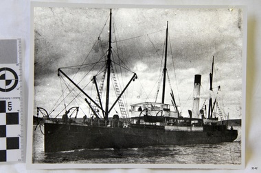
Black and White Photograph of S.S Casino taken 1930-1932. Ship has men on deck and a man at the helm. Hills and the shore can be seen in the background. The S.S. Casino was a passenger and freight steamer built in Dundee, Scotland, in 1882 for the Newcastle and Hunter River Steam Navigation Company of N.S.W. She weighed 425 tons gross with a length of 160.4 feet, beam of 24.1 feet and depth of 10.2 feet. She had saloon accommodation for 35 people, forecabin for 25 more people, and she carried 300 tons of cargo. While on her delivery journey on May 30th 1882 the S.S. Casino called in at the Port of Warrnambool for coal ., narrowly escaping going ashore in gale force winds due to the quick action of the pilot. At that time, still at anchor, she impressed the directors of the Belfast and Koroit Steam Navigation Company so much that they bought her immediately; she was ideal for trade in along the West Coast of Victoria. (Belfast is the original name for Port Fairy, South West Victoria. The Belfast and Koroit Steam Navigation Company was first managed by Messers. Saltau and Osburne and after the passing of Mr. Osburne, by produce merchants Messers H. Sautau and Sons, whose had a hay and corn store and shipping agency was on the corner of Liebig and Koroit Streets in Warrnambool. ) The S.S. Casino became “the most famous steamer to operate in Victorian waters along the West Coast” by author Jack Loney. Captain Boyd was her first Master, followed by Captain Chapman, who stayed with her 1890 until 1924. Captain W. Robertson followed for a short term, then Captain Middleton then took command 1925 - 1932. The S.S. Casino had several mishaps during her life. One was on 3rd January 1898 when she collided with the S.S. Flinders in Apollo Bay with minor damage. Another was on 24th October 1924 when she grounded on a reef at Point Hawdon near Grey River and most of her cargo (of Christmas goods) had to be dumped into the sea. Then in February 1929 she was ‘holed’ when she struck a submerged object as she entered Lady Bay, Warrnambool. On the morning of 10th July 1932, after attempting to berth at Apollo Bay jetty in heavy seas, Captain Middleton decided to take her out into the bay and wait until the seas abated. It was not realised that the anchor used to steady her as she manoeuvred to her berth had pierced her hull. She put about and headed for the beach but sank. Captain Middleton and nine others lost their lives; nine people were rescued including the two female passengers . Captain Middleton had been in charge of the S.S. Casino for seven years. He was the first ship’s Master to lose his life through shipwreck in the West Coast trade. In the years following the turn of the century the S.S. Casino remained the only regular trader with normal passenger accommodation along the West Coast. From 1882 she had made at least 2,500 voyages on the one run. Flagstaff Hill’s collection has a photograph of a portrait of Captain Chapman, , a ship model of the S.S. Casino that shows both forms of power under which she sailed, steam and sail. The ship is painted green and flies three flags. The inscription across the case of the ship model, incorrectly dated, tells the sad story of the wreck of the ship and the loss of lives on July 10th 1932 at Apollo Bay. A print in the Collection show S.S. Casino underway in heavy sea off Point Lonsdale, another two photographs show her at the Port of Warrnambool, leaving from the Breakwater in Lady Bay and another identifies the S.S. Casino as a ship from the Belfast and Koroit Steam Navigation Company. (Belfast is the original name for the township of Port Fairy). This ohotograph is significant because of its association with the coastal trader S.S. Casino 1882-1932 and its significance to trade along Victoria's West Coast in the late 19th and early 20th century. The wreck of the S.S. Casino is considered an important part of Victorian and Australian cultural heritage and as such has been declared and protected as an Historic Shipwreck under State and Commonwealth Law in the Commonwealth Historic Shipwrecks Act (1976). Black and White Photograph of S.S Casino taken 1932-1932. Ship has men on deck and a man at the helm. Hills and the shore can be seen in the background.flagstaff hill, warrnambool, shipwrecked coast, flagstaff hill maritime museum, maritime museum, shipwreck coast, flagstaff hill maritime village, great ocean road, newcastle and hunter river steam navigation company, belfast and koroit steam navigation company, h. sautau and sons, s.s. casino, west coast trader s.s. casino, victorian coastal trader, captain boyd, captain w. robertson, captain chapman, captain middleton, apollo bay shipwreck, s.s. casino at lady bay warrnambool, saltau and osburne -
 Flagstaff Hill Maritime Museum and Village
Photograph - Coastal Scene, 1930-1932
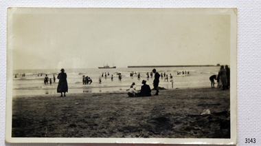
The black and white photograph is a typical beach scene taken at Lady Bay, Warrnambool, between 1930 and 1932. In the background is the coastal trader, the steamship SS Casino. Adults and children are in the foreground, playing on the beach and in the water. The Warrnambool Breakwater is on the horizon. The S.S. Casino was a passenger and freight steamer built in Dundee, Scotland, in 1882 for the Newcastle and Hunter River Steam Navigation Company of N.S.W. The vessel weighed 425 tons gross with a length of 160.4 feet, a beam of 24.1 feet and a depth of 10.2 feet. Accommodation for 35 people was provided in the saloon, and 25 passengers in the fore-cabin, plus room for 300 tons of cargo. On May 30th 1882 the S.S. Casino called in at the Port of Warrnambool for coal, narrowly escaping being swept ashore in gale-force winds due to the pilot's quick action. At that time, still at anchor, the directors of the Belfast and Koroit Steam Navigation Company were so impressed that they bought the S S Casino immediately; being ideally suited for trade along the West Coast of Victoria; Belfast is the original name for Port Fairy, South West Victoria. The Belfast and Koroit Steam Navigation Company was first managed by Messers Saltau and Osburne, and after the passing of Mr Osburne, by produce merchants Messers H. Sautau and Sons, owners of a hay and corn store and shipping agency was on the corner of Liebig and Koroit Streets in Warrnambool. The S.S. Casino was named “the most famous steamer to operate in Victorian waters along the West Coast” by maritime author Jack Loney. Captain Boyd was her first Master, followed by Captain Chapman, who stayed with her from 1890 until 1924. Captain W. Robertson followed for a short term, and then Captain Middleton took command from 1925 to 1932. The S.S. Casino had several mishaps during her life. One was on 3rd January 1898 when the ship collided with the S.S. Flinders in Apollo Bay with minor damage. Another was on 24th October 1924 when the Casino was grounded on a reef at Point Hawdon near Grey River and most of her cargo of Christmas goods had to be dumped into the sea. Then in February 1929, the Casino was ‘holed’ when it struck a submerged object as it entered Lady Bay, Warrnambool. On the morning of 10th July 1932, after attempting to berth at Apollo Bay jetty in heavy seas, Captain Middleton decided to take S S Casino out into the bay and wait until the seas abated. It was not realised that the anchor that steadied the ship during a manoeuver had pierced its hull, and it sank as it headed for the beach. Captain Middleton and nine others lost their lives, but nine people were rescued including the two female passengers. Captain Middleton had been in charge of the S.S. Casino for seven years. He was the first ship’s Master to lose his life in a shipwreck in the West Coast trade. In the years following the turn of the century, the S.S. Casino remained the only regular trader with normal passenger accommodation along the West Coast. From 1882 it had made at least 2,500 voyages on the one run. Flagstaff Hill’s collection has a portrait photograph of Captain Chapman, a ship model of the S.S. Casino that shows both forms of power under which it sailed, steam and sail. The ship is painted green and flies three flags. The inscription across the case of the ship model, incorrectly dated, tells the sad story of the wreck of the ship and the loss of lives on July 10th 1932 at Apollo Bay. A print in the Collection shows S.S. Casino underway in the heavy sea off Point Lonsdale, another two photographs show it at the Port of Warrnambool, leaving from the Breakwater in Lady Bay, and another identifies the S.S. Casino as a ship from the Belfast and Koroit Steam Navigation Company.The photograph shows an example of the Warrnambool community and family bathing and beach activities of the 1930s. The photograph is significant because of its association with the coastal trader S.S. Casino 1882-1932 and its significance to cargo and passenger trade along Victoria's West Coast in the late 19th and early 20th centuries. The wreck of the S.S. Casino is considered an important part of Victorian and Australian cultural heritage and as such has been declared and protected as a Historic Shipwreck under State and Commonwealth Law in the Commonwealth Historic Shipwrecks Act (1976). Black and white photograph of steamship S.S Casino. Taken from the beach, adults and children on shore and in the water. Circa 1930-1932.newcastle and hunter river steam navigation company, belfast and koroit steam navigation company, h. sautau and sons, s.s. casino, west coast trader s.s. casino, victorian coastal trader, captain boyd, captain w. robertson, captain chapman, captain middleton, apollo bay shipwreck, lady bay warrnambool, saltau and osburne, port of warrnambool, warrnambool breakwater, beach, bathing, 1039, 1931, 1932, beach scene, swim -
 Flagstaff Hill Maritime Museum and Village
Photograph - Coastal Scene, 1930-1932
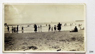
The black and white photograph is a typical beach scene taken at Lady Bay, Warrnambool, between 1930 and 1932. In the background is the coastal trader, the steamship SS Casino. Adults and children are in the foreground, playing on the beach and in the water. The old jetty is on the left and the Warrnambool Breakwater is on the horizon. The S.S. Casino was a passenger and freight steamer built in Dundee, Scotland, in 1882 for the Newcastle and Hunter River Steam Navigation Company of N.S.W. The vessel weighed 425 tons gross with a length of 160.4 feet, a beam of 24.1 feet and a depth of 10.2 feet. Accommodation for 35 people was provided in the saloon, and 25 passengers in the fore-cabin, plus room for 300 tons of cargo. On May 30th 1882 the S.S. Casino called in at the Port of Warrnambool for coal, narrowly escaping being swept ashore in gale-force winds due to the pilot's quick action. At that time, still at anchor, the directors of the Belfast and Koroit Steam Navigation Company were so impressed that they bought the S S Casino immediately; being ideally suited for trade along the West Coast of Victoria; Belfast is the original name for Port Fairy, South West Victoria. The Belfast and Koroit Steam Navigation Company was first managed by Messers Saltau and Osburne, and after the passing of Mr Osburne, by produce merchants Messers H. Sautau and Sons, owners of a hay and corn store and shipping agency was on the corner of Liebig and Koroit Streets in Warrnambool. The S.S. Casino was named “the most famous steamer to operate in Victorian waters along the West Coast” by maritime author Jack Loney. Captain Boyd was her first Master, followed by Captain Chapman, who stayed with her from 1890 until 1924. Captain W. Robertson followed for a short term, and then Captain Middleton took command from 1925 to 1932. The S.S. Casino had several mishaps during her life. One was on 3rd January 1898 when the ship collided with the S.S. Flinders in Apollo Bay with minor damage. Another was on 24th October 1924 when the Casino was grounded on a reef at Point Hawdon near Grey River and most of her cargo of Christmas goods had to be dumped into the sea. Then in February 1929, the Casino was ‘holed’ when it struck a submerged object as it entered Lady Bay, Warrnambool. On the morning of 10th July 1932, after attempting to berth at Apollo Bay jetty in heavy seas, Captain Middleton decided to take S S Casino out into the bay and wait until the seas abated. It was not realised that the anchor that steadied the ship during a manoeuver had pierced its hull, and it sank as it headed for the beach. Captain Middleton and nine others lost their lives, but nine people were rescued including the two female passengers. Captain Middleton had been in charge of the S.S. Casino for seven years. He was the first ship’s Master to lose his life in a shipwreck in the West Coast trade. In the years following the turn of the century, the S.S. Casino remained the only regular trader with normal passenger accommodation along the West Coast. From 1882 it had made at least 2,500 voyages on the one run. Flagstaff Hill’s collection has a portrait photograph of Captain Chapman, a ship model of the S.S. Casino that shows both forms of power under which it sailed, steam and sail. The ship is painted green and flies three flags. The inscription across the case of the ship model, incorrectly dated, tells the sad story of the wreck of the ship and the loss of lives on July 10th 1932 at Apollo Bay. A print in the Collection shows S.S. Casino underway in the heavy sea off Point Lonsdale, another two photographs show it at the Port of Warrnambool, leaving from the Breakwater in Lady Bay, and another identifies the S.S. Casino as a ship from the Belfast and Koroit Steam Navigation Company.The photograph shows an example of the Warrnambool community and family bathing and beach activities of the 1930s. It also shows a point in time when the jetty and the Breakwater were in the Bay. The photograph is significant because of its association with the coastal trader S.S. Casino 1882-1932 and its significance to cargo and passenger trade along Victoria's West Coast in the late 19th and early 20th centuries. The wreck of the S.S. Casino is considered an important part of Victorian and Australian cultural heritage and as such has been declared and protected as a Historic Shipwreck under State and Commonwealth Law in the Commonwealth Historic Shipwrecks Act (1976).Black and white photograph of steamship S.S Casino leaving Warrnambool. Taken from the beach, adults and children on shore and in the water. There is a jetty on the left and and the Breakwater on the right. Circa 1930-1932.newcastle and hunter river steam navigation company, belfast and koroit steam navigation company, h. sautau and sons, s.s. casino, west coast trader s.s. casino, victorian coastal trader, captain boyd, captain w. robertson, captain chapman, captain middleton, apollo bay shipwreck, lady bay warrnambool, saltau and osburne, port of warrnambool, warrnambool breakwater, beach, bathing, 1039, 1931, 1932, beach scene, swim, warrnambool jetty -
 Flagstaff Hill Maritime Museum and Village
Photograph
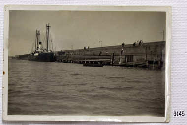
Black and White Photograph of S.S Casino taken 1930-1932. The Casino is berthed at the Warrnambool Breakwater, either loading or unloading. A person is attending a container at the bottom of a ramp between ship to Breakwater. People are sitting or standing on the Breakwater. The S.S. Casino was a passenger and freight steamer built in Dundee, Scotland, in 1882 for the Newcastle and Hunter River Steam Navigation Company of N.S.W. She weighed 425 tons gross with a length of 160.4 feet, beam of 24.1 feet and depth of 10.2 feet. She had saloon accommodation for 35 people, forecabin for 25 more people, and she carried 300 tons of cargo. While on her delivery journey on May 30th 1882 the S.S. Casino called in at the Port of Warrnambool for coal ., narrowly escaping going ashore in gale force winds due to the quick action of the pilot. At that time, still at anchor, she impressed the directors of the Belfast and Koroit Steam Navigation Company so much that they bought her immediately; she was ideal for trade in along the West Coast of Victoria. (Belfast is the original name for Port Fairy, South West Victoria. The Belfast and Koroit Steam Navigation Company was first managed by Messers. Saltau and Osburne and after the passing of Mr. Osburne, by produce merchants Messers H. Sautau and Sons, whose had a hay and corn store and shipping agency was on the corner of Liebig and Koroit Streets in Warrnambool. ) The S.S. Casino became “the most famous steamer to operate in Victorian waters along the West Coast” by author Jack Loney. Captain Boyd was her first Master, followed by Captain Chapman, who stayed with her 1890 until 1924. Captain W. Robertson followed for a short term, then Captain Middleton then took command 1925 - 1932. The S.S. Casino had several mishaps during her life. One was on 3rd January 1898 when she collided with the S.S. Flinders in Apollo Bay with minor damage. Another was on 24th October 1924 when she grounded on a reef at Point Hawdon near Grey River and most of her cargo (of Christmas goods) had to be dumped into the sea. Then in February 1929 she was ‘holed’ when she struck a submerged object as she entered Lady Bay, Warrnambool. On the morning of 10th July 1932, after attempting to berth at Apollo Bay jetty in heavy seas, Captain Middleton decided to take her out into the bay and wait until the seas abated. It was not realised that the anchor used to steady her as she manoeuvred to her berth had pierced her hull. She put about and headed for the beach but sank. Captain Middleton and nine others lost their lives; nine people were rescued including the two female passengers . Captain Middleton had been in charge of the S.S. Casino for seven years. He was the first ship’s Master to lose his life through shipwreck in the West Coast trade. In the years following the turn of the century the S.S. Casino remained the only regular trader with normal passenger accommodation along the West Coast. From 1882 she had made at least 2,500 voyages on the one run. Flagstaff Hill’s collection has a photograph of a portrait of Captain Chapman, , a ship model of the S.S. Casino that shows both forms of power under which she sailed, steam and sail. The ship is painted green and flies three flags. The inscription across the case of the ship model, incorrectly dated, tells the sad story of the wreck of the ship and the loss of lives on July 10th 1932 at Apollo Bay. A print in the Collection show S.S. Casino underway in heavy sea off Point Lonsdale, another two photographs show her at the Port of Warrnambool, leaving from the Breakwater in Lady Bay and another identifies the S.S. Casino as a ship from the Belfast and Koroit Steam Navigation Company. (Belfast is the original name for the township of Port Fairy). This object is significant because of its association with the coastal trader S.S. Casino 1882-1932 and its significance to trade along Victoria's West Coast in the late 19th and early 20th century. The wreck of the S.S. Casino is considered an important part of Victorian and Australian cultural heritage and as such has been declared and protected as an Historic Shipwreck under State and Commonwealth Law in the Commonwealth Historic Shipwrecks Act (1976). Black and White Photograph of S.S Casino taken 1930-1932. The Casino is berthed at the Warrnambool Breakwater, either loading or unloading. A person is attending a container at the bottom of a ramp between ship to Breakwater. People are sitting or standing on the Breakwater.flagstaff hill, warrnambool, shipwrecked coast, flagstaff hill maritime museum, maritime museum, shipwreck coast, flagstaff hill maritime village, great ocean road, newcastle and hunter river steam navigation company, belfast and koroit steam navigation company, h. sautau and sons, s.s. casino, west coast trader s.s. casino, victorian coastal trader, captain boyd, captain w. robertson, captain chapman, captain middleton, apollo bay shipwreck, s.s. casino at lady bay warrnambool, saltau and osburne