Showing 209 items
matching wash road
-
 Greensborough Historical Society
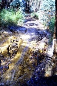
Slide - Photograph, John Ramsdale, Barbers Creek, Mernda: Slide 6, 1990s
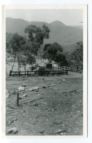
Photograph shows washed out bush track with gully erosion at Barbers Creek, Mernda.Part of the John Ramsdale collection of slides and audio visual material.Colour photograph scanned from slide.No maker's marks. No caption on slide.erosion, barbers creek mernda -
 Greensborough Historical Society
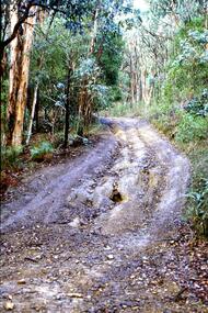
Slide - Photograph, John Ramsdale, Gully erosion - motorbike track: Slide 77, 1990s
Photograph shows a washed out bush track - Gully erosion caused by motorbike trackPart of the John Ramsdale collection of slides and audio visual material.Colour photograph scanned from slide.No maker's marks. No caption on slide.erosion, gully erosion -
![Photograph - Digital Image, Merilyn Mullavey, Rotoract Club of Greensborough c1970 [Car wash], 1970_](/media/collectors/4f729f5697f83e03086015b8/items/5d74c39621ea671ddc42a101/item-media/5d74c3d421ea671ddc4323b0/item-fit-380x285.jpg) Greensborough Historical Society
Greensborough Historical SocietyPhotograph - Digital Image, Merilyn Mullavey, Rotoract Club of Greensborough c1970 [Car wash], 1970_
Members of the Rotaract Club of Greensborough, participating in a car wash activity; taken in the 1970s.Digital copy of colour photograph.rotaract club of greensborough -
 Greensborough Historical Society
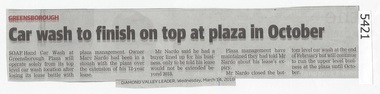
Newspaper Clipping, Diamond Valley Leader, Car wash to finish on top at plaza in October, 14/03/2018
Soap Hand Car Wash at Greensborough Plaza will operate solely from its top level car wash location after losing its lease battle with plaza management.News article 1 page, black text.soap hand car wash, greensborough plaza, marc nardo -
 Greensborough Historical Society
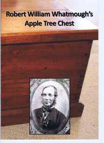
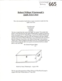
Book, Robert William Whatmough's Apple Tree Chest, 1878o
A brief history of Robert Whatmough's apple tree chest as inscribed on paper and attached to inside lid of chest. Contains photographs of the chest and articles about the owners and makers. This chest was made from the trunk of an apple tree washed down the Plenty River to Greensborough in 1878. [Published c2012]Published by a descendent of the Whatmough family with access to several family artefacts.20 pages, colour and black and white illus.robert william whatmough, steve whatmough sarah wilson, apple tree chest, plenty river -
 Glenelg Shire Council Cultural Collection
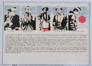
Print, Angela Gee, Tuna Fishing Pt Lincoln, 1986
UnknownFive portraits of male figures in five square at top of print. Each man is in a different pose, with a blue wash background. Underneath are hand-written inscriptions identifying them as different people involved in the tuna-fising industry. The bottom part of the print is a handwritten short essay on the tuna-fishing industry. Mounted without a matt in a pale blue metal frame with glass glazing.Front: 9/40 (lower left) Tuna Fishing, Pt Lincoln (lower centre) Angela Gee '86 (lower right) (pencil) Back: (no inscriptions) -
 Greensborough Historical Society
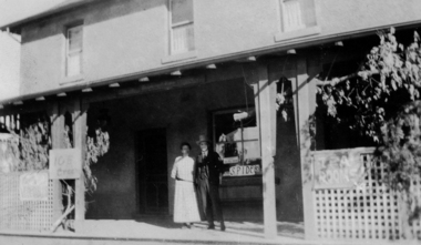
Photograph - Digital image, Marble Hall, 1930-1940
Photograph of "Marble Hall", Greensborough. The Marble Hotel, Greensborough was located at the corner of Main Street and Para Road. The first licensed hotel in Greensborough and one of the earliest brick buildings was built by James Chapman in the early 1850s as a hotel and lodging house to cater for wood carters and those trying their luck at the gold fields but served many functions over the years including post office, general store, public hall, butchers, bakers, surgery, private dwelling and baby health care centre. It got its name due to its white washed exterior. This photo is from the Lorraine Coates Collection.Photograph of early Greensborough building, now demolished.Digital copy of black and white photograph.marble hotel greensborough, james chapman, marble hall greensborough -
 Greensborough Historical Society
Manuscript, Late Thoughts! by June Roberts, 1958-1978
This was prepared by June Roberts with assistance from Grace Cavill. Written in 1978 it includes details of Greensborough's Main Street from circa 1958-1978.Describes the locations of the Main Street traders in the 1950s. Also mentions the efforts needed to replace the Plenty River footbridge after it was washed away in a flood.A 3 page typed manuscript and a hand drawn plan of Greensborough shopping area based on the document.Sept 78 in blue biro on front page.main street shops, tom vickers, hume street, griffiths haberdashery, popes, flintoff street, plenty river bridge, stubleys hardware, stan ashleys menswear, hume street residences, rob willett, ashril theatre -
 Greensborough Historical Society
Article, Robert William Whatmough's Apple Tree Chest, 1880_
A brief history of Robert Whatmough's apple tree chest as inscribed on paper and attached to inside lid of chest.This chest was made from the trunk of an apple tree washed down the Plenty River to Greensborough in 1878. 1 page of text with line drawingwhatmough, apple tree chest -
 Greensborough Historical Society
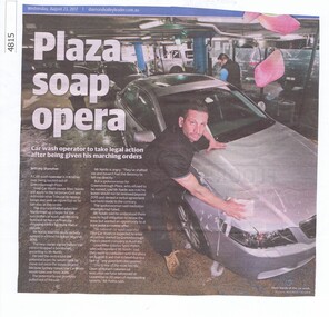
Newspaper Clipping, Diamond Valley Leader, Plaza soap opera, 23/08/2017
A car wash operator is in a lather over being booted out of Greensborough Plaza.News article 1 page, black text, colour image.greensborough plaza, soap car wash, mark nardo -
 Glenelg Shire Council Cultural Collection
Medal - Medal - Syd Cuffe, Town Crier, c. 2001
Medal, round brass, black front, brass lettering and border. Hole at top of medal, ring attached, with red, white and blue striped ribbon. Medal measures 7.8cm diameterFront: Anacores Arts Festival, 9th World Championship 2001. The Ancient and Honourable Guild of Town Criers Back: Inscribe ' SYDNEY CUFFE GLENELG SHIRE AUSTRALIA', maker's details -
 City of Moorabbin Historical Society (Operating the Box Cottage Museum)
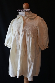
Clothing - Clothing, child's cream 'Viyella' coat, c1900
This small child’s cream, ‘Viyella’ coat is an example of the dressmaking skills of the women of the pioneer settlers families in Moorabbin Shire c1900. The material is very soft and easy to sew, wash and iron and was therefore very popular for all ages. Viyella material The original owner of the Mill, Wm. Hollins also ran the mill in Pleasley, U.K. on a rather unusually named road ‘Via Gellia’ now the A5012 near Matlock, about 20miles away. Via-Gellia later gave its name to the famous soft fabric ‘Viyella’ which Hollins & Co patented in 1893. Later Viyella was also to become the company name in 1961 after a merger. Viyella has faded into obscurity now, and in 2009 went into administration, finally being bought out by Austin Reed.A cream 'Viyella' small child's long sleeved coat, buttoned front and smocked frontclothing, moorabbin, ormond, bentleigh, dressmaking, market gardeners, early settlers, craftwork, textiles, viyella -
Glenelg Shire Council Cultural Collection
Domestic object - Cream Bottle (284m/½ pint), n.d
Clear glass narrow mouth cream bottle 284ml/half pint. Measurements 14.5cm high x top 4.5 x Bottom 5.5Front: '284ml HALF PINT - embossed Back: 'WASH and RETURN' - embossed Base: 'Symbol 16m PBM-315' - embossed -
 Halls Gap & Grampians Historical Society
Photograph - Sepia, C 1900
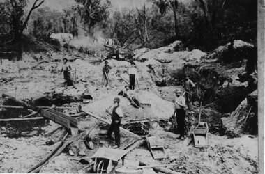
Horton's Reward Claim. This group of miners also worked another area called 'The Heather Bell" approx. 200 yards further up the gully. About half a pennyweight to the dish is obtained from the wash near the creek. They are panning off 3 dwts per day off one man's ground. This claim is about the best fitted up on the field. It is worked with a sluice box with iron ripples and feeder to match. The latter is a great advantage as there is a great fall below the claim for the tailings.Photo shows seven men working a goldfield using shovels and picks.mining, mount william, people -
 Halls Gap & Grampians Historical Society
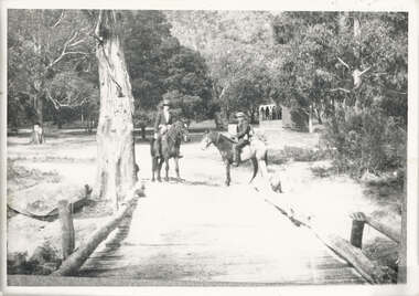
Photograph - B/W, C 1920s
The Stoney Creek dray bridge. Stoney Creek has been bridged a number of times on school road since the creek was re-routed in the early 1900s. A dray bridge was built C 1910 by local residents, which stood them in good stead for more than a decade. This bridge was replaced by a higher timber structure. Image two is a story from 1906 relating to Marshall White and his family trying to recross Delley's bridge after finding the Stoney Creek dray bridge washed away.Photo of two men on horseback on a wooden bridge with low log railing. A shelter can be seen in the background and there are thick trees surrounding the road.structures, bridges -
 Eltham District Historical Society Inc
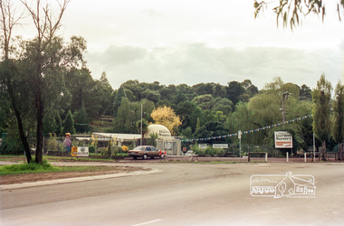
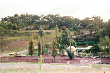
Photograph, The Garden Nursery at 1419 Main Road, Eltham at the corner of Kalbar Road, c.1987
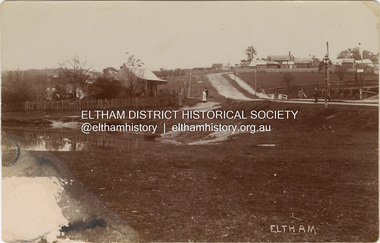
... melbourne Now a 7-Elleven and car wash roads main road kalbar road ...Now a 7-Elleven and car washRoll of 35mm colour negative film, 7 stripsKodak GA 100 5095roads, main road, kalbar road -
 Eltham District Historical Society Inc
Photograph, The Garden Nursery at 1419 Main Road, Eltham at the corner of Kalbar Road, c.1987
... melbourne Now a 7-Elleven and car wash roads main road kalbar road ...Now a 7-Elleven and car washRoll of 35mm colour negative film, 7 stripsKodak GA 100 5095roads, main road, kalbar road -
 Kiewa Valley Historical Society
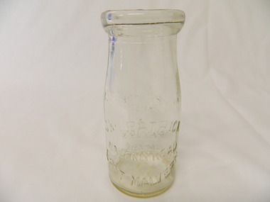
Bottle - Cream, 1935
Cream came in bottles bought at the local store or at a large city store on a shopping expedition. The shape of the bottles changed as did the stopper used to seal it. The amount of liquid was measured in ounces and pints pre 1966. History of J. Kikpatrick, Waverley, East malvern.Historical: Change of bottles - shape, size, stopper, embossing and use. Aesthetic; Display showing embossing and shapeClear small glass cream bottle with heavy embossing on both sides. Inside the opening is a rim to hold a cardboard disc used to seal the bottle. The sides are straight half way up then taper to the opening. One side: The Property of / J. Kilpatrick (half moon on top) / Waverly Road (across middle) / East Malvern (half moon on bottom) Other side: Please / wash / & / Return (also curved with & in the middle) Along side at base: "Contents not less than 8 ozs." Base: Across middle M93 above M, and AGM below. cream, dairy, milkbar, bottle, household -
 Kiewa Valley Historical Society
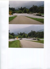
Photos - x2 Damms Road River Crossing
Damms Road river crossing after the c1993 floods of the Kiewa River. The old bridge was inundated, later to be washed away.The Kiewa River flooded in 1993 at Damms Road when the old bridge was washed away.2 coloured photos of the Kiewa River in flood at Damms Roadkiewa river flooding, bridge at damms road -
 Eltham District Historical Society Inc
Photograph, Old Bridge, Kaylock's Crossing, Brougham Street, Eltham, c.1895
Brougham Street was created in Josiah Holloway's 1851 subdivision of Little Eltham. It was one of several east-west streets shown on the subdivision plan as crossing the Diamond Creek. The western part was named Wellington Street on the subdivision plan but was later changed to conform with the name of the eastern part as acknowledgement of the continuity of the street. It is not known when the first bridge was constructed in Brougham Street however it was certainly mentioned at Council’s meeting of 2 June 1884 as being in a dangerous state of repair. This photo (c.1895) of an old bridge shows a very low-level simple log girder bridge crossing the creek at a right angle and so the approaches involved bends in the road alignment. This bridge was generally known as Kaylocks Bridge or Kaylock’s Crossing after the owner of the adjoining land. It was most likely built from around the mid-1850s, or a crossing of some fashion established as Richard George Kaylock, butcher of Little Eltham and his wife Emily Ann settled there in 1854. His property was in Wellington Street (now Brougham Street) and apparently extended across the Diamond Creek. The land on the western side of the creek was farmed, the house being on the eastern side. Kaylock's Bridge formed part of the original coach road to Eltham and in 1922 was described as an "old rustic bridge". Its low level and insubstantial construction made it susceptible to flood damage, necessitating frequent closures until repairs could be carried out. In September 1922, Council called for tenders for a new timber bridge to be constructed at Kaylock’s crossing. An engineering assessment carried out for the Council by Macleod Consulting at the time of the replacement suggested that the construction details indicate that it was in the 1900s, however this dating could possibly have been the result of numerous repairs undertaken over the years to flood damage. The tender was awarded to Mr Weller of Kangaroo Ground who commenced work in February 1923 on a higher-level timber trestle bridge. Work was slowed due to illness of the contractor and the accidental death of a man in March 1923 following the collapse of the bank after he had jumped into a hole that had just been blasted. The bridge was completed around July 1923 at which point the old structure was pulled up, marking what was described in the ‘Advertiser’ newspaper as the passing of an old and well-loved landmark in the district. In April 1924 the approach to Kaylocks bridge was washed away during the heavy flooding that destroyed the Main Road bridge. The western side was repaired, and an extra span was added to the eastern side using timber from the destroyed Main Road bridge. The bridge was again severely damaged four months later in August 1924 When a lack of finances delayed repairs to the Bridge Street bridge in 1931 (also referred to as Obelisk Bridge at the time), traffic had to detour via Brougham Street for some time. Local residents feared that the Bridge Street bridge might never reopen. Kaylocks Bridge was constantly subject to damage by floods. In the 1934 flood it was submerged by two feet of water. In more recent times the bridge was again severely damaged by flooding and repairs made. A new bridge and adjoining footbridge were constructed in 2009. Part of a slide show presentation "Bridges & Waterways of the Shire" by Russell Yeoman to the 13 September 1989 Society meeting. The presentation included slides of historic photos from the Shire of Eltham Pioneers collections as well as several recent views.Photo of earliest known crossing of the Diamond Creek at brougham StreetPostcard photo printbrougham street, eltham, wellington street, kaylocks bridge, bridge, diamond creek (creek) -
 Eltham District Historical Society Inc
Photograph, J.H. Clark, Maria Street, Eltham, c.1910
William Jarrold's cottage on left was used by the Police 1858-1860. The Court house and Police precinct (upper right) were opened in 1859-1860 Photographer: J.H. Clark John Henry Clark was the youngest of three boys born to William Henry Clark (1823-1877) and Maria White (1843-1914). He and his brothers, William Charles Clark (1872-1945), Clement Kent Clark (1874-1912) operated a photography business (Clark Bros.) from 25 Thomas Street, Windsor near Prahran during the period c.1894 to 1914. Following death of Clement in September 1912 and their mother in 1914, the Clark Bros business appears to have dissolved, the premises demolished, and a new house was under construction in 1915. John set up business independently in 1914 operating out of 29 Moor Street, Fitzroy where he is registered in the 1914 and 1915 Electoral Rolls. By 1916 John had relocated to Eltham where he continued his practice as a photographer and took many of the early images around the district of Little Eltham. Around 1930 John changed professions and opened a small cobbler's shop in 1931 near the pond opposite Dalton Street adjacent to the Jarrold family cottage. He never married and continued his profession as a bootmaker from this little shop, maintaining a close relationship with Mrs Jarrold for the rest of their lives. His bootmaker shop remains today beside the Whitecloud cottage and is one of only three remaining shops in the area from the early 20th century. There are a couple of images of Eltham taken by Clark Bros. in the Eltham District Historical Society collection, one such example being Hunniford’s Post Office with Miss Anne Hunniford out front (EDHS_00140 - marked on the back of the print, Clark Bros., 25 Thomas St. Windsor), which would date this image between c.1894 and 1914. Other early images of Eltham taken by John Henry Clark are marked on the face “J. H. Clark Photo” and it is assumed these are dated between 1914 and 1930. It is noted that the Grant of Probate for John H Clark of Eltham South dated 5 April 1957 (513/387) records his occupation as "X Photographer".Sepia postcardNotations in biro 'A. Petrie', rest in pencil as follows Telegraph poles show one wire No 1918 Avenue of Honour trees c.1907 Jarrolds house No shop at White Cloud on fence line Police Residence has extensions Chimney on wash house Office Brickwork on stables Lock-up, entry and window end Light lamp - cnr Dalton and Maria streets Surface damage to lower left cornermain road, eltham, maria street, dalton street, william jarrold, jarrold cottage, police residence, courthouse, j.h. clark photo -
 Warrnambool RSL Sub Branch
Dress Jacket Army Reserve, Fletcher Jones & Staff, 1998
This jacket is part of the dress uniform of a Major in the Army Reserve. Major Bernard Farley who owned this jacket wore it to official functions in the Mess dining room. He served in this capacity from 1998-2001.Bernard also served in the RAAF for a number of years.This jacket has significance as it is typical of dress requirements which were worn to official Army functions.Short white jacket with wide front lapels epaulets at the shoulders and a small V shaped downward peak at the back. The sleeves have a stitched over section at the cuff with a point in line with the shoulder. On each epaulet from the collar edge side there is a brass coloured button with the Rising Sun in low relief and on the lower edge of the epaulet a brass coloured crown with red nsert and a circular shaped badge with the word Australia. There is a badge on each lapel two crossed rifles holding a crown in brass colour over the top of a silver VLabel states ,' Fetcher Jones Victoria 1998 NSN 8405-NIC Name....... Service No......... Polyester / Viscose Dry Cleanable ( A) Warm Gentle Machine Wash Rinse well. Warm iron. ZC785 BR1689 425267911.ZC785 107 R 347 044 05037649 cloth br 1689 17. J10129 OW Wwarrnambool, army reserve, dress jacket -
 Victoria Police Museum
Police Stations (Armadale)
Armadale is an inner suburb of Melbourne, Victoria, Australia, 7 km south-east of Melbourne's Central Business District, located within the City of Stonnington local government area. Armadale Police Station opened, in Melbourne Police District, on 11 May 1885. Its original location is unknown, but in 1890 it is listed in the Sands & McDougall directory as at 295 Hight Street. From 1985-1920 it was located at 20/22 Auburn Grove, 1925-1930 at 769 High Street and 1935-1946 at 3 Cheel Street. The station closed on 28 January 1946. The sub-division east of Orrong Rd was incorporated into Malvern Sub-district and west of Orrong Road into Prahran Sub-district. In a special 1930 issue of the Victoria Police Gazette the Armadale Police Station was described as a seven-roomed brick dwelling with a tiled roof on land measuring 127' x 104' x 98'. There was also a bathroom and W.C., a wash-house, office, and a lock-up (one cell). This is probably a description of the Cheel Street police station. It was staffed by one senior constable and three foot constables.12 photographs comprising 8 coloured images and 4 black and white images 1 sketch plan of Old Armadale Police Stationpolice stations; armadale police station -
 Victoria Police Museum
Police Stations (Ascot Vale)
Ascot Vale is an inner suburb 6 km north-west of Melbourne, Victoria, Australia in the local government area of the City of Moonee Valley. Ascot Vale police station was opened on 31 October 1887 in the Melbourne Police District. From 1900-1905 it was located at 54 Parade, Ascot Vale; from 1910-1925 at 71 St Leonards Road; from 1930-1953 at 37 St Leonards Road. In 1953 it was relocated to government owned premises at 111 Union Road until the police station closed on 1st May 1970 and the Sub-district was divided between Flemington and Moonee Ponds police stations. The former police station was used by the Crime Car Squad until about 1987 when the premises were damaged by fire. The police station at 37 St Leonards Road was described as a six-roomed brick dwelling with slate and iron roof on land measuring 150' x 50'. There was also a bathroom and W.C., wash-house, office and lock-up with one cell. It was staffed by one second-class sergeant and four foot constables. The purpose-built police station at 111 Union Road included a four-roomed residence with the exterior clad in rough cast Conite and a tile roof. There was also a kitchen, bathroom, laundry and separate garage. 4 black and white photospolice stations; ascot vale police station -
 Eltham District Historical Society Inc
Negative - Photograph, Warrandyte Bridge over River Yarra, c.1910
View of the 1875 timber trestle bridge over the Yarra River reproduced from a newsprint image. Also known as Anderson's Creek (Road) Bridge A contract was accepted for William Elliot to erect a bridge over the Yarra River at Warrandyte on Anderson's Creek Road and other improvements for £1,331.6.2 - Gazette No. 143. Tuesday, November 13th 1860 - http://gazette.slv.vic.gov.au/view.cgi?year=1860&class=general&page_num=2161&state=V&classNum=G143&id=). The bridge was washed away by floods in 1863. It was replaced with a taller timber trestle structure in October 1875, designed and built by C.S. Wingrove, Shire Clerk, Engineer and Surveyor for Eltham Shire Council. A replacement for this bridge was commenced in 1955 to cope with increasing traffic and this structure was widened in 2018 to meet further traffic demands. Argus (Melbourne, Vic. : 1848 - 1957), Thursday 23 September 1875, page 7 ________________________________________ THE WARRANDYTE BRIDGE. The ceremony of formally opening the newly erected bridge over the Yarra at Ander-son's Creek was performed on Monday last, in the presence of the members of the Eltham and Bulleen shire councils whose territories it joins, and a goodly number of the residents of the district. The task was delegated to Mr. Cameron, M.L.A., who, after a few introductory remarks declared the bridge to be opened, and christened it the " Warrandyte Bridge." The party then adjourned to Grant's Hotel, where a cold collation had been prepared. The chair was taken by the president of the Eltham shire (Mr. John Bell) and the vice chair by Mr. Kent, a member of the Bulleen council. Mr Robert Williamson proposed "Success to the bridge," coupling with it the name of Mr. Cameron, to whose exertions was in the main to be attributed the erection of that structure which was an ornament to the district and would prove of great service to both sides of the river. Mr. Cameron, in responding, alluded to the great difficulties, mainly of a pecuniary nature, that had been encountered in carrying out the project, and which had only been got over by their united efforts and by the liberal spirit in which the late Commissioner of Roads had dealt with the case. The healths of the contractor and the engineer were also drunk. The bridge is a trussed timber one, resting on yellow box piles sunk into the solid rock, each pier being weighted with 50 tons of stone. The abutments consist of dry stone walls, 6ft. thick at the base, and tapering to 3ft. on the top, the face of the work having a batter of 1 to 1. The length of the bridge is 308ft., there being four openings in the centre of 66ft. each, and two at the ends of 20ft. each. The width in the clear is 9½ft., and the height from the bed of the river about 33ft. The approaches comprise 1,100 cubic yards of earthwork, and the formation of 48 chains of sideling, the whole cost of the work, which was carried out under the direction of the engineer to the Eltham Shire Council, being £1,413.This photo forms part of a collection of photographs gathered by the Shire of Eltham for their centenary project book,"Pioneers and Painters: 100 years of the Shire of Eltham" by Alan Marshall (1971). The collection of over 500 images is held in partnership between Eltham District Historical Society and Yarra Plenty Regional Library (Eltham Library) and is now formally known as the 'The Shire of Eltham Pioneers Photograph Collection.' It is significant in being the first community sourced collection representing the places and people of the Shire's first one hundred years.Digital image 4 x 5 inch B&W Neg B&W Print 12.5 x 9 cmsepp, shire of eltham pioneers photograph collection, warrandyte, bridge -
 Ringwood and District Historical Society
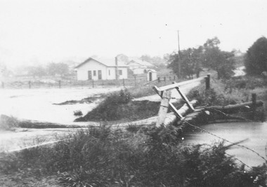
Photograph, Bridge connecting Adelaide St. and Reynolds Av., Ringwood. pre 1931
Written on back of photograph, "Bridge connecting Adelaide St. and Reynolds Av. Washed away in 1931 by the flooded Mullum Creek. Looking towards Reynolds Ave." -
 Ringwood and District Historical Society
Photograph, Mullum Creek in flood, Ringwood. Adelaide St. Bridge to Reynolds Ave washed away, 1931
Catalogue card reads, "Mullum Creek in flood. Adelaide St. Bridge to Reynolds Ave washed away, 1931". Typed below photograph, "Adelaide St. bridge, to Reynolds Ave washed out in 1931 (Bridge not replaced). 1934?" -
 Orbost & District Historical Society
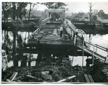
black and white photographs, 1934
These photographs were taken just after the McKillop's Bridge was completed after the flood damage. The current McKillop’s Bridge was built by the Country Roads Board in two stages between 1931-36, during which its height was raised after the original bridge superstructure was washed away in record floods of January 1934, prior to its original official opening. In its reconstructed form the original concrete abutments were turned into additional piers and the welded-steel trusses were cantilevered back over them to meet the new higher road approaches. It is sited at McKillops Crossing, named after pioneer overlanding squatter George McKillop who crossed here in 1835. This was a stock crossing place for almost a century before the bridge was constructed. (info. from Victoria Heritage Register)This is a pictorial record of the history of McKillop's Bridge, in itself of historical significance for its association with Victoria's long and important pastoral history, its technicl significance and aesthetic significance.Three black / white photographs. 3133.1 shows the approach to a washed away bridge. 3133.2 is of a bridge over a river with men clearing debris. 3133.3 is a close-up showing the wreckage of the bridge.mckillop's-bridge snowy-river flood-damage-1934 -
 Orbost & District Historical Society
black and white photograph, mid 1930s
This is a photograph of McKillop's Bridge probably taken just after its rebuilding. The current McKillop’s Bridge was built by the Country Roads Board in two stages between 1931-36, during which its height was raised after the original bridge superstructure was washed away in record floods of January 1934, prior to its original official opening. In its reconstructed form the original concrete abutments were turned into additional piers and the welded-steel trusses were cantilevered back over them to meet the new higher road approaches. "McKillops Bridge was Heritage listed due to its social and technological significance – the steel trusses' arc-welded construction technique was a pretty big deal in the 1930s. It was once an important route for cattlemen, who used the ford across the Snowy in the years preceding the bridge's existence"This is a pictorial record of McKillop's Bridge just after its construction.A black / white photograph of a wooden bridge across a river. At the bottom right is a man with his back to the camera. He is looking at flood debris on the bank. At the bottom left are two men near a pylon.on back - McKillops Bridgebridge-mckillop's snowy-river-bridge -
 Orbost & District Historical Society
black and white photographs, February 17 1971
... when the abutment to the Snowy River road bridge was washed... when the abutment to the Snowy River road bridge was washed ...After the damage from the February 1971 floods at Orbost when the abutment to the Snowy River road bridge was washed away a Bailey bridge, portable, pre-fabricated, truss bridge, was put into place to ensure town access, the C.R.B. rebuilt the approach to the bridge driving new piles and constructing the Bailey bridge. They worked late into the night under flood lights to ensure the link from the Orbost township to the Princes Freeway would be open to traffic as soon as possible.These photographs are pictorial records of a significant event in the history of Orbost.Three black / white photographs of a Bailey bridge being erected across a river. 3245.1 and 3245.2 are the same. bailey-bridge orbost-snowy-river-bridge bridge-orbost