Showing 87 items matching "water resources"
-
 Federation University Historical Collection
Book, John Ferres, Government Printer, Victorian Government Prize Essays 1860, 1861, 1861
Royal Society of Victoria Government prize essays Brown soft covered book with the following contents: Preface Collection and Storage of Water in Victoria by Frederick Acheson (gold washing, irrigation, motive-power, general water supply, artesian wells) Agriculture of Victoria by William Story (geological and chemical character of s oils, rotation of crops, sources and application of manures.) Origin and Distribution of Gold in Quartz Veins by Henry Rosales Development of Resources in the Colonyroyal sociey of victoria, gervernment prize essays, soils, water, agriculture, gold, quartz, henry rosales, frederick acheson, william story, charles mayes, quartz mining -
 Bendigo Historical Society Inc.
Document - BENDIGO - THE HEART OF VICTORIA
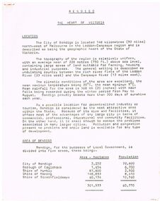
Typed article titled Bendigo, The Heart of Victoria. Items mentioned are Location, Area of Bendigo, The People, Work Force, Industrial Base, natural Resources, Agriculture and Livestock, Minerals, Forests, Rail and Road, Sea and Air, Power and Water, Electricity, Natural Gas, Water, Sewerage, Industrial Land, Services, Community Services and Facilities, Educational Facilities, Hospitals, Culture and Tourism and Media.document, bendigo - the heart of victoria, city of bendigo, borough of eaglehawk, shire of huntly, shire of marong, shire of strathfieldsaye, bendigo development committee, department of agriculture, department of state development decentralization and tourism, state electricity commission, gas & fuel corporation of victoria, state rivers & water supply commission, bendigo sewerage authority, the bendigo college of advanced education, home and hospital for the aged, home for the blind, northern school of nursing, art gallery, historical society, dudley house, sun loong, central deborah gold mine, the vintage talking trams and transport museum, bcv8, the bendigo advertiser, golden city gazette, 3bo, 3cv, mr a j kelly -
 Bendigo Historical Society Inc.
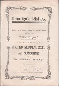
Book - KEN HESSE COLLECTION: BENDIGO'S RICHES
2 copies of a white booklet titled, 'Bendigo's Riches.' This is a reprint of a series of articles printed in 'The Argus' on the potential wealth of the water supply, soil, and sunshine of the Bendigo district. Published Melbourne, Wilson and Mackinnon, Printers, Collins St. Melbourne. 15 pgs. ph. 1909. Item part of the Mr. Ken Hesse collection donated by Mr. James Lerk.rural industry, agriculture - cultivation, bendigo, ken hesse collection, collection, bendigo, the argus, bendigo resources, resources, agriculture, farming, mining -
 Melbourne Water
Photograph - Steel Pipeline, 1952
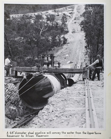
The Upper Yarra Reservoir supplies the Silvan Reservoir, which distributes water throughout the Melbourne metropolitan area. The dam was completed in 1957 and is a rolled earthfill and rockfill embankment. This photograph shows a 68" diameter steel pipeline that was to convey the water from the Upper Yarra Reservoir to the Silvan Reservoir.This photograph is significant as it provides a detailed insight into the Boards activity and construction of one of Melbourne's most important water supply systems. Furthermore, it is of historical importance to the history of Melbourne while it is representative of shaping Melbourne's environments, transforming and managing land and natural resources, and providing urban infrastructure and services. The photograph itself is aesthetically pleasing, through its depth of field and use of shape with an interesting composition. Black and white photographmmbw, melbourne metropolitan board of works, melbourne water, upper yarra reservoir, silvan reservoir, water, waterway, dam -
 Melbourne Water
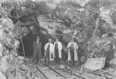
Photograph - Tunnel at the O'Shannasy Dam, 9th April 1921
The O'Shannassy Reservoir supplies water to the Silvan Reservoir, which distributes it to most parts of Melbourne. The dam was completed in 1928 and is an earthfill embankment with a reinforced concrete core wall.This photograph is significant as it provides a detailed insight into the Boards activity and construction of one of Melbourne's most important water supply systems. Furthermore, it is of historical importance to the history of Melbourne while it is representative of shaping Melbourne's environments, transforming and managing land and natural resources, and providing urban infrastructure and services. This photograph also covers the theme of Safety, depicting the safety standards of the time particularly with clothing. Black and white photographmmbw, melbourne metropolitan board of works, melbourne water, silvan reservoir, o'shannassy reservoir, construction, work, men, infrastructure -
 Yarra City Council
Artwork, other - Installation/Sculpture, Troy Innocent, Joel Collins, Indae Hwang, Yun Tae Nam, Drop Zone, 2011
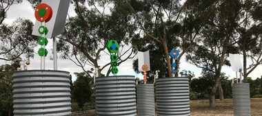
... points for potential conflict over water resources. The water ...'Drop Zone', is set in an imagined future where decreasing water availability has affected us more dramatically than anyone predicted. The water shortage has become so severe that we have to access water on a first-come first-serve basis, from military-like water ‘drop zones’, like this one, made from modified rain water tanks. These tanks function on three levels: Collected rain water causes the totem sculptures to rise and bloom; evaporation causes the totem sculptures to fall; and an anemometer (device that measures wind speed) drives a process that plays the tank like a giant drum, tuned by the amount of water contained within. This artwork envisions a future for Australia where the impact of decreasing water availability has had a more dramatic effect than any of the predictions. The shortage is so severe that military-like water ‘drop zones’, constructed of modified rainfall storage tanks have been established across the public parks of the City of Yarra for access on a first come, first serve basis. However, as the water is only replenished through rain catchment the tanks may only offer infrequent relief for the City of Yarra residents, standing as hollow reminders of the effects of inaction on the shaping of sustainable national water use.'Drop Zone' was one of three public art works installed in Yarra, in 2011, under the banner of The Environmental Public Arts Project which responded to key features of Council's Environment Strategy: 'Towards Local Sustainability 2008-2020.' The aims of this project included activating public spaces in new and creative ways through the creation of artworks which act as catalysts for further engagement and discussion around environmental themes and issues.Copyright the Artists. Ready-made corrugated water tanks arranged on a site. Situated within the tanks are small totemic sculptures that float on top of the water within the tank.Accompanying plaquesustainability, water, environment, climate change -
 Creswick Campus Historical Collection - University of Melbourne
Booklet, Utilization of Timber Resources on Watersheds, 1959
Subject: evidence presented to the State Development committeeon its enquiry into the utilization of timber resources in the watersheds of the state.Booklet -
Creswick Campus Historical Collection - University of Melbourne
Document
Documents relating to the Nepal - Australia Forestry Project ResourcesDocuments -
Creswick Campus Historical Collection - University of Melbourne
Ephemera
2 cards showing - IMPACT. IZOD - Brittleness. Munitions Supply Laboratory Maribyrnong.Teaching resources -
Whitehorse Historical Society Inc.
Document, Whitehorse ecovision, 1/09/2002 12:00:00 AM
Whitehorse Council report - a strategy for ecological sustainability.Whitehorse Council report - a strategy for ecological sustainability. Includes basic statistics, information and detailed proposals for sustainable use of energy, water. Protection of biodiversity, Transport, Effects on the community.Whitehorse Council report - a strategy for ecological sustainability. city of whitehorse, water conservation, wildlife conservation, conservation of natural resources, pollution -
 Whitehorse Historical Society Inc.
Pamphlet, Eastern Freeway Extension, 1/08/1998 12:00:00 AM
Information bulletin giving history map showing features of extension,Information bulletin giving history map showing features of extension, members of liaison group established for consultation.Information bulletin giving history map showing features of extension,freeways, springvale road, nunawading, mitcham road, mitcham, park road, mullum mullum creek, deep creek road, loughnan road, ringwood, harrison street, acacia court, maroondah highway, city of whitehorse, city of manningham, city of maroondah, melbourne water, victoria. department of natural resources and environment, environment protection authority, victoria, vicroads, eastern freeway -
 Bendigo Historical Society Inc.
Document - HERITAGE REPORT: FORMER POLICE STATION AND QUARTERS: CALIFORNIA GULLY
Seventeen page Heritage Place Report on the Former California Gully Police Station at 15 Thorpe Street, California Gully. It is the former police station and quarters, former timber stables and timber cottage residence demolished and horse paddock on separate title. Report includes a Statement of Significance, Place History (History of the Area), Policing California Gully Goldfields, History of the Buildings, Chronology of Ownership, Rate Books 1858, - 1867 - 1868, 1895 Borough of Eaglehawk Rates, 1922 Voters Roll, 1952 & 1962 Sands & McDougall Directory Thorpe St California Gully, Comparable Examples, Secondary Sources, Description Conservation Policy Guidelines (Specific), Physical Conditions, Physical Description 1, Map of Early Photo Location, Bendigo Parish Plan circa 1870, Certificate of Title 1950 & 1960. Pge 14 has plans, maps and an aerial photo of 15 Thorpe Street. Page 15 has an aerial photo of 15 Thorpe Street, California Gully with Allotment Size. Page 16 & 17 has photos.heritage, heritage report - former police station and quarters - california gully, city of greater bendigo, wilson & ass, butler, amanda jean, johnson reef shafts no 1 & 2, rose of denmark, princess dagmar, bendigo amalgamated goldfields company, captain frederick standish, royal irish constabulary, e thorpe, campbell, taylor, watson, brown, hosken, mckowne, mcqualter, parker, hicks, eaglehawk municipal council, victorian police force, d bannear, historic mining sites in the sandhurst eaglehawk and raywood mining divisions, department of conservation and natural resources, joshua thorpe, thorpe & co, johnson & co, william thorn, michael thomas, james murdock, edward c brown, francis youlden, gold escort, water police, mounted police, city police (melbourne), geelong police, gold fields police, rural bench constabulary, the people's force, robert haldane, n wild, streets of the borough of eaglehawk, police registration act, william henry mitchell, camp hotel, j o c nieman, j m catarach, g w hosken, margaret hosken nee mckown, majorie alice mcqualter, kellie anne mcqualter, adam joseph doolan, mr hicks, sands & mcdougall, hill george, meeking howard, mcewan frank a, jinks stanley, mccaig mrs eleanor, gordon john l, mcqualter mrs adeline, maher william l, raynor robert, flack john p, whitehead miss a, sang george t, linddsay john p, dyer henry, jackman george a, tibbetts mrs s a, hosken mrs margaret winifred nee mckowne, chaplin frank w, wilson c e, wright george, miller g a, sheyhill basil hugh, marshall r, miles j h, parker w b, barkla w g, nicholls les, cartledge clifford william, cole charles basil, farmers citizens trustees co, bev hanson -
 Queenscliffe Maritime Museum
Tool - Navigation, ship's Log, 25 May 2011
A Ship's Log looked very similar to a torpedo but was used to measure the speed of a ship. When dragged behind the vessel, movement of water past the propeller caused it to rotate, turning the small needle dials to record the distance and speed travelled. https://museumsvictoria.com.au/immigrationmuseum/resources/journeys-to-australia/Ship's Log Display HeadWalkers Cherub 111 ships lognavigation, speed, knot, chip log, log, thomas walker and son -
Bendigo Historical Society Inc.
Booklet - The Eppalock Catchment
Yellow covered booklet of 36 typed and copied pages entitled 'Project for Environmental Education Resources Development. THE EPPALOCK CATCHMENT Sub-Catchment What's Up the Creek? A Resource for Teachers. Includes a diagram of the Water Cycle, 2 maps of the Pohlman's Creek Catchment and Soil Studies. Also includes Pre-Excursion, Excursion and Post- Excursion Activities as well as Record Sheets for Excursions. The name 'Dr W.N.Holsworth' is stamped on the front cover and the date 29 April 1981lake eppalock, catchment study, teachers' resource -
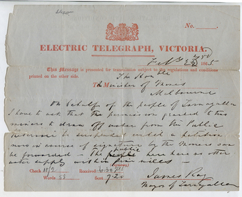 Tarnagulla History Archive
Telegram: Mayor of Tarnagulla to the Minister of Mines, Melbourne, 22nd February 1865
... . tarnagulla post office telegrams minister mining mining water ...Murray Comrie Collection. A telegram sent from James Ray, Mayor of Tarnagulla to the Minister for Mines, Melbourne on 22nd February 1865. Reads: "On behalf of the people of Tarnagulla I have to ask that the permission granted to two miners to draw off water from the Public Reservoir be suspended until a petition now in course of signatures by the miners can be forwarded. The public here have no other water supply within five miles."tarnagulla, post office, telegrams, minister mining, mining, water, reservoir, recreation reserve, resources -
 Wodonga & District Historical Society Inc
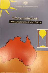
Book - Time Running Out: Shaping Regional Australia's Future, Australia. Parliament. House of Representatives. Standing Committee on Primary Industries and Regional Services, 2000
... (electricity, gas, renewable energy); education; water resources ...This report is the result of and inquiry into infrastructure and the development of Australia's regional areas by the House of Representatives, Standing Committee on Primary Industries and Regional Services. The foreword to the Committee's report states that the title 'Time running out' reinforces the urgent need to firstly acknowledge the deficiencies in infrastructure that exist throughout regional Australia and secondly, the need to remedy that lack of infrastructure. Action is needed to ensure that many regional communities don't just survive but learn to thrive once again. Chapters focus on major issues of leadership and local skills; policy, planning and coordination; and finance and investment. Other chapters focus on particular sectors or issues including advanced telecommunications; information technology; transport (roads, rail, shipping, airports); energy (electricity, gas, renewable energy); education; water resources; and health.non-fictionThis report is the result of and inquiry into infrastructure and the development of Australia's regional areas by the House of Representatives, Standing Committee on Primary Industries and Regional Services. The foreword to the Committee's report states that the title 'Time running out' reinforces the urgent need to firstly acknowledge the deficiencies in infrastructure that exist throughout regional Australia and secondly, the need to remedy that lack of infrastructure. Action is needed to ensure that many regional communities don't just survive but learn to thrive once again. Chapters focus on major issues of leadership and local skills; policy, planning and coordination; and finance and investment. Other chapters focus on particular sectors or issues including advanced telecommunications; information technology; transport (roads, rail, shipping, airports); energy (electricity, gas, renewable energy); education; water resources; and health.infrastructure regional australia, regional planning australia -
 Wodonga & District Historical Society Inc
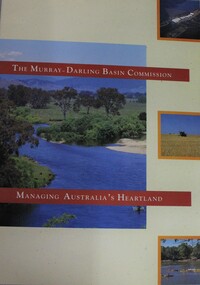
Booklet - Murray-Darling Basin Commission: Managing Australia's Heartland, 1992
This 16 page booklet outlines the role of the Murray-Darling Commission and water management strategies. It includes colour illustrations and maps.non-fictionThis 16 page booklet outlines the role of the Murray-Darling Commission and water management strategies. It includes colour illustrations and maps.murray-darling basin management, natural resources, murray-darling basin commission (australia) -
 Wodonga & District Historical Society Inc
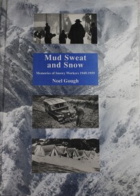
Book - Mud Sweat and Snow: Memories of Snowy Workers 1949-1959, Noel Gough, 1994
... of water resources in the Snowy Mountains area. As a result ...This book tells the human story of the first decade of building the great Snowy Mountains Hydro-Electric Scheme, with adventures and anecdotes told by the workers themselves, and illustrated with unusual photographs. Appendices give further information about the project and list the workers named in Snowy records. The author began his 10 years with the Electrical and Mechanical Division at the age of 20. The construction of the Snowy Mountains Hydro-electric Scheme is a well-documented part of our nation’s history and a leading example of Australian innovation and ingenuity. As far back as the 1880s, Australians had been considering diverting water from some of Australia’s best-known rivers – the Murray, Murrumbidgee, Snowy and Tumut – to drought-proof parts of NSW and Victoria. It was not until 1944 that Commonwealth and State governments formed a committee to examine the development of water resources in the Snowy Mountains area. As a result of their work, on 7 July 1949, the Commonwealth Parliament passed legislation to establish a Statutory Authority and start construction of the Snowy Scheme. NSW. Construction was completed in 1974 at a total cost of $820 million. On completion, the Scheme consisted of seven power stations, 16 major dams, 80 kilometres of aqueducts and 145 kilometres of interconnected tunnels.non-fictionThis book tells the human story of the first decade of building the great Snowy Mountains Hydro-Electric Scheme, with adventures and anecdotes told by the workers themselves, and illustrated with unusual photographs. Appendices give further information about the project and list the workers named in Snowy records. The author began his 10 years with the Electrical and Mechanical Division at the age of 20. The construction of the Snowy Mountains Hydro-electric Scheme is a well-documented part of our nation’s history and a leading example of Australian innovation and ingenuity. As far back as the 1880s, Australians had been considering diverting water from some of Australia’s best-known rivers – the Murray, Murrumbidgee, Snowy and Tumut – to drought-proof parts of NSW and Victoria. It was not until 1944 that Commonwealth and State governments formed a committee to examine the development of water resources in the Snowy Mountains area. As a result of their work, on 7 July 1949, the Commonwealth Parliament passed legislation to establish a Statutory Authority and start construction of the Snowy Scheme. NSW. Construction was completed in 1974 at a total cost of $820 million. On completion, the Scheme consisted of seven power stations, 16 major dams, 80 kilometres of aqueducts and 145 kilometres of interconnected tunnels.snowy mountains hydro-electric scheme, hydroelectric power plants, snowy mountains -
 City of Kingston
Photograph - Colour, Paul Tresize, 1998
The name Mordialloc was derived from the name Moody Yallock, which comes from the Bunurong language. The Bunurong Peoples are the Traditional Owners of this area. The name means “high water” or “high creek”. In 1839, colonial authorities declared the mouth of the creek, and an additional 830 odd acres as an Aboriginal Reserve, although this proclamation was never gazetted. The reserved land included part of the Carrum Carrum Swamp which was abundant with wild life and natural resources. Regular encroachments, including land sales which began in 1863, were made on the land until 1878 when the Reserve was declared closed, and the land was opened up to land sales. Market gardening and suburban house lots quickly began to develop, and Mordialloc became a renowned picnic and holiday site. Mordialloc Creek is a popular bay side destination for local and visitors, and is a site for boating, kayaking, fishing and swimming, along with many other activities.Colour photograph of Mordialloc Creek, looking out to the bay. Many small fishing and leisure craft are moored on either side of the banks of the creek. To the right hand side can be seen parklands, while the left hand side has a small inlet in which more small crafts are moored.mordialloc, bunurong, traditional owners, suburbs, boats, fishing, waterways -
 City of Kingston
Photograph - Colour, 1998
The name Mordialloc was derived from the name Moody Yallock, which comes from the Bunurong language. The Bunurong Peoples are the Traditional Owners of this area. The name means “high water” or “high creek”. In 1839, colonial authorities declared the mouth of the creek, and an additional 830 odd acres as an Aboriginal Reserve, although this proclamation was never gazetted. The reserved land included part of the Carrum Carrum Swamp which was abundant with wild life and natural resources. Regular encroachments, including land sales which began in 1863, were made on the land until 1878 when the Reserve was declared closed, and the land was opened up to land sales. Market gardening and suburban house lots quickly began to develop, and Mordialloc became a renowned picnic and holiday site. Mordialloc Creek is a popular bay side destination for local and visitors, and is a site for boating, kayaking, fishing and swimming, along with many other activities.Colour photograph of Mordialloc Creek, looking inland.Small fishing and leisure boats are moored on either side of creek, with a view of the Mordialloc Bridge Hotel in the background.mordialloc, bunurong, traditional owners, suburbs, boats, fishing, waterways, hotel -
City of Kingston
Photograph - Colour, Paul Tresize, 1998
The name Mordialloc was derived from the name Moody Yallock, which comes from the Bunurong language. The Bunurong Peoples are the Traditional Owners of this area. The name means “high water” or “high creek”. In 1839, colonial authorities declared the mouth of the creek, and an additional 830 odd acres as an Aboriginal Reserve, although this proclamation was never gazetted. The reserved land included part of the Carrum Carrum Swamp which was abundant with wild life and natural resources. Regular encroachments, including land sales which began in 1863, were made on the land until 1878 when the Reserve was declared closed, and the land was opened up to land sales. Market gardening and suburban house lots quickly began to develop, and Mordialloc became a renowned picnic and holiday site. Mordialloc Creek is a popular bay side destination for local and visitors, and is a site for boating, kayaking, fishing and swimming, along with many other activities.Colour photograph of Mordialloc Creek, looking inland. Boats are moored on either side of the creek and the Bridge Hotel is visible in the background.mordialloc, bunurong, traditional owners, suburbs, boats, fishing, waterways, hotel -
 City of Kingston
Photograph - Colour, Paul Tresize, 1998
The name Mordialloc was derived from the name Moody Yallock, which comes from the Bunurong language. The Bunurong Peoples are the Traditional Owners of this area. The name means “high water” or “high creek”. In 1839, colonial authorities declared the mouth of the creek, and an additional 830 odd acres as an Aboriginal Reserve, although this proclamation was never gazetted. The reserved land included part of the Carrum Carrum Swamp which was abundant with wild life and natural resources. Regular encroachments, including land sales which began in 1863, were made on the land until 1878 when the Reserve was declared closed, and the land was opened up to land sales. Market gardening and suburban house lots quickly began to develop, and Mordialloc became a renowned picnic and holiday site. Mordialloc Creek is a popular bay side destination for local and visitors, and is a site for boating, kayaking, fishing and swimming, along with many other activities.Colour photograph of Mordialloc Creek with boats moored on both sides of the street and Pompei's boat yard visible on the right hand side of the creek., Main Street and St Brigid's Catholic Church are visible in backgroundmordialloc, bunurong, traditional owners, suburbs, boats, fishing, waterways, hotel, church -
City of Kingston
Photograph - Colour, Paul Tresize, 1998
The name Mordialloc was derived from the name Moody Yallock, which comes from the Bunurong language. The Bunurong Peoples are the Traditional Owners of this area. The name means “high water” or “high creek”. In 1839, colonial authorities declared the mouth of the creek, and an additional 830 odd acres as an Aboriginal Reserve, although this proclamation was never gazetted. The reserved land included part of the Carrum Carrum Swamp which was abundant with wild life and natural resources. Regular encroachments, including land sales which began in 1863, were made on the land until 1878 when the Reserve was declared closed, and the land was opened up to land sales. Market gardening and suburban house lots quickly began to develop, and Mordialloc became a renowned picnic and holiday site. Mordialloc Creek is a popular bay side destination for local and visitors, and is a site for boating, kayaking, fishing and swimming, along with many other activities.Colour photograph of Mordialloc Creek with boats moored on both sides of the street and Pompei's boat yard visible on the right hand side of the creek., Main Street and St Brigid's Catholic Church are visible in background.mordialloc, bunurong, traditional owners, boats, fishing -
 Mrs Aeneas Gunn Memorial Library
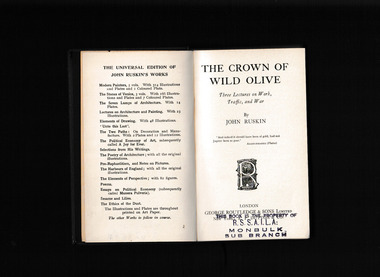
Book, George Routledge and Sons, The crown of wild olive : three lectures on industry & war
... . In this way, mining the ground for metals, water, and other resources ...This 1866 collection of essays on "Work," "Traffic," and "War," begins with a preface condemning the human depletion of nature for what Ruskin saw as valueless gains. In this way, mining the ground for metals, water, and other resources parallels the work of the three lecture topics--all is done for the money. But what Ruskin wants to know is what the ultimate effect and product of their work is?Index, notes, p.132.non-fictionThis 1866 collection of essays on "Work," "Traffic," and "War," begins with a preface condemning the human depletion of nature for what Ruskin saw as valueless gains. In this way, mining the ground for metals, water, and other resources parallels the work of the three lecture topics--all is done for the money. But what Ruskin wants to know is what the ultimate effect and product of their work is? john ruskin 1819-1900, ethics -
 Eltham District Historical Society Inc
Document - Property Binder, 1184 Main Road, Eltham
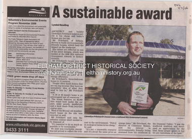
Newspaper article: A sustainable award, Diamond Valley Leader, 1 November2006, Architect and building Llewellyn Pritchard won resource Efficiency Housing Award, finalist in HIA Greensmart Building of the Year Award. House – Environmental Leader (Published: Nillumbik Now and Then / Marguerite Marshall 2008; photographs Alan King with Marguerite Marshall.; p186) In 2006 environmental awareness was mushrooming in the community, which is reflected in the award-winning house at Main Road near Wattletree Road, Eltham. At first sight, the building appears a mix of a classic Eltham mud-brick house and an avant-garde building style. The crown of solar panels stretching along the width of the curved roof, indicates that this is no ordinary house. In fact it signals a new building trend of minimal impact on the environment. Yet it utilises the environment with high technical expertise to achieve comfort and cut running and maintenance costs. In recognition of this, its designer/builder, Conscious Homes, won the 2006 National HIA Greensmart Resource Efficiency Award. For Conscious Homes director, Llewellyn Pritchard, this house reflects a philosophy, strengthened by his connection with Aboriginal culture, through his foster siblings. Pritchard believes the sustainable way indigenous Australians lived and their spiritual connection with land, demonstrates how humanity is part of the ecology. His interest in environmental design stemmed from growing up in bushy Eltham Shire, with its mud-brick tradition. This was followed by studying Architecture at RMIT in the early 1980s, and learning about passive solar design. Pritchard says this house demonstrates that environmental sustainability is not about sacrifice, but about exceptional levels of occupant comfort, savings in running costs and modern fittings and appliances.1 The solar panels on the north roofs are intentionally obvious to make a statement about what the building is doing. But inside the systems are hidden and interactive with conventional services, such as the underground water tank. The house is water and energy self-sufficient and at 12 squares is much smaller than conventional houses, to minimise resources. Yet it accommodates his family of four with three bedrooms, a living/dining and kitchen area and a bathroom/laundry. Importantly the building is designed to last hundreds of years, by being able to be modified as the need arises, such as for commercial use. In this way the structure minimises its environmental impact. The solid double mud-brick walls (which are insulated) include steel beams and supporting frame, allowing the future removal or alteration of any section. The materials are local, recycled and of low toxicity where possible.2 Inside and out, the mud-brick is rendered and sealed with a combination of cement and sand and a mud-based coating in a soft golden hue increases its life. Inside, the golden-brown timber is plantation Mountain Ash and the concrete floors throughout – of local stone aggregate with a clear seal – have a natural looking random stone appearance. The house sustains a stable temperature of around 20 degrees, assisted by the concrete slab floor. The many large double-glazed windows and highlights (windows set high on walls) provide cross-flow ventilation. The north-facing living area maximises heating from the lower winter sun and is cooler in summer, because the sun is higher. Heating comes from a solar hydronic slab system. All appliances and fittings are high efficiency energy or water rated. Appliances in the timber kitchen include a gas stove and a dishwasher, using the building’s own power and water. French doors open from the living area to a deck, concealing the treatment system for all waste water. This is pumped through sub-soil drippers to the indigenous garden beds and no-dig vegetable patch. Below the carport is the 80,000-litre rainwater tank and at the back, the boiler room houses the solar boiler, water tank access, domestic water supply pump, filter gear and hydronic slab heating controls. The solar system is backed up with gas, which is needed to heat water only in winter. Gas used is less than one quarter of that for an average home with ducted heating. Excess power is fed back to the grid and the building uses about one quarter of the mains electricity of an average home. Other local builders have followed Pritchard’s lead in resource efficiency for minimal environmental impact.main road, eltham, businesses, llewellyn pritchard, hia greensmart building of the year award., efficiency housing award, conscious homes australia pty ltd -
Bendigo Historical Society Inc.
Booklet - The Eppalock Catchment
Yellow covered booklet of 36 pages typed and photocopied. On front cover 'Project for Environmental Education Resources Development.' 'THE EPPALOCK CATCHMENT Sub Catchment Study What's up the Creek?' B&W sketch of a river on front cover. This is a resource document for teachers and includes a diagram of the Water Cycle, maps of the Pohlman's Creek Catchment area and soil studies. -
Lakes Entrance Historical Society
Book, The Department of Industry Science and Resources, Analysis of Snowy Mountain Hydro Scheme, 2000
Analysis of the complexity of water flow issues, electricity market implications and broader social economic and environmental considerations associated with the operation of the Snowy Mountains SchemeISBN 06427211440environment, water supply, waterways