Showing 1122 items
matching waterway
-
 Lakes Entrance Historical Society
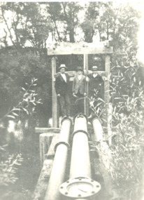
Photograph - mining in Gippsland Victoria, 1920 c
Black and white photograph showing three men standing at three water pipes beside a waterway which appears to be an abandoned pumping station perhaps associated with mining in Gippsland Victoriatopography, transport -
 Lakes Entrance Historical Society
Photograph, G Legg Bairnsdale, Tambo River at Mossiface Victoria, `1970 1980 c
This narrow waterway was the original steamer route to the Port of MossifaceBlack and white photograph of the Tambo River adjoining Arthur Howletts property at Mossiface Victoriaboats and boating, rivers -
 Federation University Historical Collection
Map, Ballaarat Gold Field, 1861, 21/10/1861
A party of surveyors camped by Yuille's Swamp (later Lake Wendouree) and surveyed the countryside for a map to be produced by the Geological Survey of Victoria. In November 2004 the Central Highlands Regional Library presented a special edition of 200 copies of the 1861 map reproduced from a copy in their collection. Original geological map of Ballarat showing property, waterways, mines, churches, schools, water races, and garden reserves. It was compiled and drawn from the surveys of Mining Surveyors Davidson, Fitzpatrick and Cowan.Compiled & Drawn from the Survey of Mining Surveyors Davidson, Fitzpatrick and Cowan & the Plans in the Surveyor General's Office by J. Brahe, 21st October 1861. R. Brough Smyth, Secretary for Mines. The Honourable J.B. Humffray, M.L.A. Commr of Mines.ballarat, map, davidson, robert brough-smyth, fitzpatrick, cowan, yuille's swamp, public garden reserve, manure depot, black hill, ballarat east, old post office hill, pennyweight hill, claytons hill, golden point, mining, railway, cricket ground, swamp creek, cemetery, sludge reserve, bakery hill, gaelic church, juvenile reformatory, orphanage, specimen hill, eureka lead, cattle yard hill, dalton's flat, chinese village, poverty hill, railway reserve, little bendigo diggings, pound reserve, allied armies, flour mill, agricultural reserve, marsh, survey reserve, survey corps, white flat, yarrowee, yarrowee creek, brache, j. brache, survey, ballaarat gold field 1861 -
 Hume City Civic Collection
Photograph, Bulla Mill
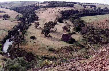
The waterway is the Deep Creek at Bulla. Originally this was the site of one of the earliest mills in the district.In the early days of European settlement a number of mills were established on the banks of both the Jackson and Deep Creeks in Bulla and Sunbury.A coloured photograph of a valley surrounded by hills with the ruins of a stone building on the horseshoe bend of the creek. deep creek, mills, bulla bulla -
 Parks Victoria - Days Mill and Farm
Container - Traps
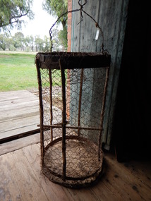
Possibly used for catching freshwater crayfish or yabbies, nearby in the Goulburn River or other waterways. of critical significanceHOMEMADE WIRE TRAPS x 2. Made from chicken wire. Iron bands supported by green timber lengths. Wire handles with metal spike probably for securing trap to bank/ ground.fishing, food -
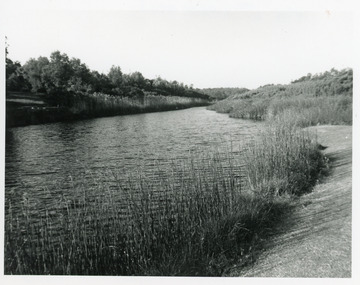 Lakes Entrance Historical Society
Photograph - Warm Hole, Lakes Post Newspaper, 1993
The Warm Holes are the remnants of Reeves River, the original waterway of the natural entrance to the Gippsland Lakes.Black and white photograph of the fourth warm hole, looking eastward, Lakes Entrance, Victoria. waterways, vegetation -
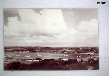 Bendigo Military Museum
Photograph - PHOTOGRAPH, AIR FORCE, C. WW2 onwards
Photo, black & white, this is a distant shot showing patchy/cloudy sky. There is a waterway in the centre with 8 Sunderland Aircraft moored in it. The Tactical Air Command are facing left. The foreground shows buildings, a crane & trees.photography-photographs, military history - air force, sunderland, passchendaele barracks trust -
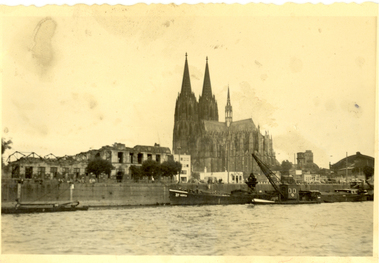 Federation University Historical Collection
Photograph - black and white, Cologne Cathedral from the Rhine, c1950
Cologne Cathedral is a renowned monument of German Catholicism and Gothic architecture and is a World Heritage Site. It is Germany's most visited landmark, attracting an average of 20,000 people a day. (Wikipedia) Though not targeted itself, the cathedral was very near to the central railway station and suffered fourteen hits by aerial bombs during World War II. Badly damaged, it nevertheless remained standing in an otherwise completely flattened city. The twin spires were an easily recognizable navigational landmark for Allied aircraft bombing deeper into Germany, which may explain why the cathedral was spared. Repairs were completed in 1956. An emergency repair on the northwest tower's base carried out in 1944 using poor-quality brick taken from a nearby ruined building remained visible until 2005 as a reminder of the war, when it was decided to restore the section its original appearance. (Wikipedia) Black and white photograph showing a grand cathedral from a waterway. It is Cologne (Koln) Cathedral from the Rhine. To the left of the photo bombed buildings are evident. The photograph is believed to have been taken by Frank Wright.cologne cathedral, koln, germany, rhine, bombing, world war two, frank wright -
 Lakes Entrance Historical Society
Book, Fish Marie and Holding Marion, Paddle Steamers of the Gippsland Lakes and Rivers, 1994
Very brief stories of the eighteen known paddle steamers which plied the Gippsland Lakes, in the era the waterways of the lakes and rivers were the major means of communications and transport for the region. Illustrated with sketches and facsimiles of docships and shipping, waterways -
Lakes Entrance Historical Society
Book, Hawkins Richard, Creeks and Harbours of the Gippsland Lakes and East Gippsland, 1989
A comprehensive boating guide to the Gippsland Lakes, Lake Tyers, Marlo, Bemm River, Sydenham, Tamboon and Mallacoota Inlets, includes short list of bird life and fish species, and description of towns bordering the waterways.waterways, boats and boating -
Ballarat Heritage Services
Photograph - Video, Clare Gervasoni, Confluence of Canadian Creek and Yarrowee River near Anderson Street, Ballarat, 06/09/2022
The waterways of central Ballarat were channeled to prevent flooding and contain sludge during the mining era.Video of the confluence of Canadian Creek and Yarrowee River near Anderson Street, Ballarat flowing down a channel.canadian creel, yarrowee river, ballarat, anderson street, channel, bluestone -
Ballarat Heritage Services
Photograph - Video, Clare Gervasoni, Specimen Vale Creek at Steinfeld Street, Ballarat, 06/09/2022
The waterways of central Ballarat were channeled to prevent flooding and contain sludge during the mining era.Video of Specimen Vale Creek at Steinfeld Street, Ballarat., Ballarat flowing down a channel.ballarat, channel, bluestone, specimen vale creek, steinfeld street -
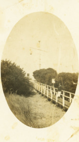 Lakes Entrance Historical Society
Photograph - Signal Station New Works, 1930 c
Also a black and white photograph of view of entrance with a steamer at sea and steamer Tamar in waterway 05277.1Black and white photograph of walkway to signal station at New Works Lakes Entrance Victorianavigation -
Lakes Entrance Historical Society
Book, Land Conservation Council Victoria, Land Conservation Council East Gippsland Area Review, 1985
Report describing the physical and biological aspects of the public land in the eastern corner of Victoria, predominantly the Orbost Shire. Many issues are covered in the report, including timber industry, national parks, waterways and tourism. Six mapsparks, waterways, tourism, gippsland -
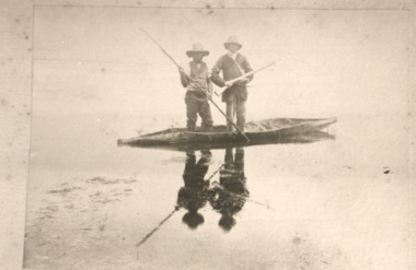 Lakes Entrance Historical Society
Photograph - Aboriginal canoe on Lake Tyers Victoria, H D Bulmer, 1905 c
Sepia toned photograph of two men one with spear other with gun standing in native canoe on Lake Tyers Victoria. Also sepia photographs of natives in three bark canoes on edge of waterway at Lake Tyers parks, recreational facilities -
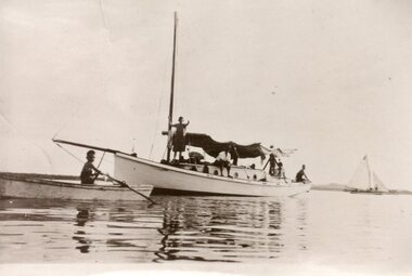 Lakes Entrance Historical Society
Photograph, 1930
Black and white photograph of an unidentified single mast yacht with sail furled motionless on waterway. Men and boys on yacht, young boy in rowing boat nearby. Yacht in full sail in background. Probably on Gippsland Lakes, Victoria.boats and boating, waterways -
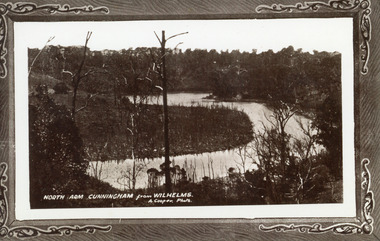 Lakes Entrance Historical Society
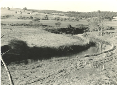
Photograph - North Arm, 1910c
Photo taken from property settled by Wilhelm family 1900c.Black and white photograph of a bend in the North Arm. It shows the waterway winding between banks covered in natural vegetation, low lying area covered with salt affected dead and dying ti-tree. Lakes Entrance VictoriaNorth Arm Cunningham from Wilhelmswaterways, vegetation -
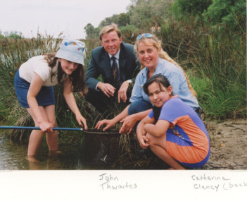 Lakes Entrance Historical Society
Photograph, Catchment Management Authority East Gippsland Victoria, 2000 c
Colour photograph showing Catherine Clancy of Catchment Management Authority with two young girls inspecting the contents of a dip net on the edge of a waterway. John Twaites Victorian Government Deputy Premier looking on East Gippsland Victoriaenvironment, waterways -
 Ballan Shire Historical Society
Map - Map. Ballark, Department of Lands and Survey, Ballark. County of Grant, 31/08/1915
A map of the Ballark area within the County of Grant showing roads, waterways, property boundaries and property owners in 1915.Significant to people researching land usage and ownership. Also those researching families in the area at that time.A map of Ballark in the County of Grant. Black printing on buff coloured paper. Extra notations by hand and various coloured highlighting of certain features. Details roads, rivers, property boundaries and names of property owners and districts. The map is easily readable although there is some physical damage to the borders and some sellotape residue. Shows a scale in Chains and the number L.6030Various numbers and directional arrows added to map.bungal, borhoneyghurk, bungeeltap, ballark, beremboke, moreep, meredith, morrisons, moorarbool river -
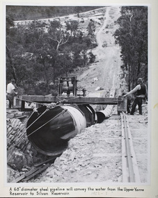 Melbourne Water
Photograph - Steel Pipeline, 1952
The Upper Yarra Reservoir supplies the Silvan Reservoir, which distributes water throughout the Melbourne metropolitan area. The dam was completed in 1957 and is a rolled earthfill and rockfill embankment. This photograph shows a 68" diameter steel pipeline that was to convey the water from the Upper Yarra Reservoir to the Silvan Reservoir.This photograph is significant as it provides a detailed insight into the Boards activity and construction of one of Melbourne's most important water supply systems. Furthermore, it is of historical importance to the history of Melbourne while it is representative of shaping Melbourne's environments, transforming and managing land and natural resources, and providing urban infrastructure and services. The photograph itself is aesthetically pleasing, through its depth of field and use of shape with an interesting composition. Black and white photographmmbw, melbourne metropolitan board of works, melbourne water, upper yarra reservoir, silvan reservoir, water, waterway, dam -
 Lakes Entrance Historical Society
Photograph, 1950c
Also enlargement 15x25cmBlack and white photograph of the Warm Holes, from the sand hummocks looking west. The Warm Holes are the remnant of Reeves River, the original waterway from the Gippsland lakes to the natural entrance. Lady with shawl in foreground. Lakes Entrance Victoria waterways, topography -
 Lakes Entrance Historical Society
Photograph - Maramingo, Lakes Post Newspaper, 2000
Photo appeared in Lakes Post 12 January 2000Colour photograph of Gippsland Ports facility at Eastern Wharf. Timber fishing vessel Maramingo on slips, timber shed on land nearby, rock wall at edge of waterway, three fishing vessels in Cunninghame Arm. Lakes Entrance Victoriaships and shipping, fishing industry -
 Lakes Entrance Historical Society
Photograph - North Arm Bridge, Davies Judy, 1999
Date made 10 April 1999Colour photograph of the southern abutment of the now North Arm Bridge during construction. Three cranes in attendance distant view of North Arm waterway, taken from walkway on old concrete road bridge. Lakes Entrance Victoriabridges, construction -
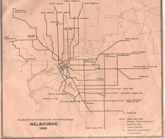 Melbourne Tram Museum
Map, Robert Green, "Melbourne 1969", 1969
Map - MMTB "Melbourne 1969" showing MMTB tram and bus routes and waterways, tram and bus depots and workshops printed on a light brown paper, prepared by R. W. Green (Robert) Shows the names of the various suburban termini.trams, tramways, map, tram routes, bus routes, depots -
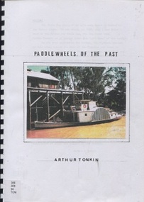 Surrey Hills Historical Society Collection
Book, Paddle wheels of the past
The discovery of inland waterways during the early settlement of Victoria and South Australia led to trade being plied up and down the rivers.An A4 80 page comb bound book.paddlewheels, paddlesteamers - murray river (nsw- sa), boats, punts, barges -
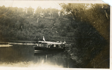 Lakes Entrance Historical Society
Postcard - MV Blackbird, Bulmers Studio, 1940
Four black and white small format postcards 6 x 8.5cm, slightly different view of the boat coming down the waterway.Black and white small format postcard showing Peels Tourist Ferry MV Blackbird leaving Comer's North Arm Jetty. Steep wooded banks, reeds along the shore. Lakes Entrance VictoriaNorth Arm Launch Trip, Lakes Entrance (on reverse)waterways, restaurant, boats and boating, tourism -
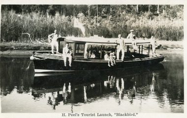 Lakes Entrance Historical Society
Postcard - MV Blackbird, Bulmers Studio, 1940c
Four black and white small format postcards 6 x 8.5cm, slightly different view of the boat coming down the waterway.Black and white postcard showing Peels launch Blackbird in North Arm. Five men posing outside, three children sitting in the side. Thick vegetation on bank. Lakes Entrance VictoriaH. Peel's Tourist Launch, 'Blackbird'waterways, boats and boating, tourism -
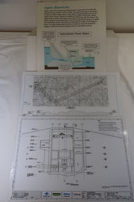 Kiewa Valley Historical Society
Plans - 2 Southern Hydro - Bogong Power Development and 1 Poster - Hydro-Electricity
Southern Hydro owned the Kiewa Hydro Electric Scheme in 2006. Southern Hydro owned the Kiewa Hydro Electric Scheme in 2006.Laminated A3 sheets The two Southern Hydro Bogong Power Development are black and white. 1. Tunnel and Civil Works / Power Station / Cross Section Sheet 4 of 6 Dated: June 2006 (Also see KVHS 1438) 2. Bogong Power / Development Waterway. Waterway Plan & Longsection / with Boreholes & Seismic Lines (Also see KVHS 1438) 3. Title: Hydro-Electricity in blue at the top and half-way down a blue and brown diagram titled 'Hydro-Electric Power Station'. At the bottom the title 'What is a watt?' southern hydro 2006, bogong power development -
 Bendigo Historical Society Inc.
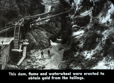
Slide - DIGGERS & MINING. DIGGERS AND MINERS, 1800s
Diggers & Mining. Diggers and Miners. This dam, flume and waterwheel were erected to obtain gold from the tailings. Picture shows the section of the dam, wheel and waterway. Markings: 41 994.5 WAL. Used as a teaching aid. Used as a teaching aid.hanimounteducation, tertiary, goldfields -
 Bayside Gallery - Bayside City Council Art & Heritage Collection
Map - print, Melbourne and Metropolitan Board of Works, Interim development order: Brighton, Moorabbin and Sandringham, 1959
The Melbourne and Metropolitan Board of Works (now Melbourne Water) was established in 1891. From that time, as part of their work laying water and sewerage connections, they created detailed plans of houses and other buildings in the Melbourne metropolitan area. In 1956 it acquired powers to construct and maintain highways and bridges, protect and improve the foreshores and create and maintain parks within the metropolitan region. This Interim development order comprises part of the municipalities of Brighton, Moorabbin and Sandringham and was made on 20 October 1959.brighton, moorabbin, sandringham, melbourne and metropolitan board of works, map, town planning, cartographic material, interim development order, bayside