Showing 113 items matching "watts river"
-
 Eltham District Historical Society Inc
Photograph, Liz Pidgeon, Heritage Excursion; Maroondah Aqueduct, 3 September 2016, 3 September 2016
... . It was built between 1886 and 1891 to transfer water from the Watts.... It was built between 1886 and 1891 to transfer water from the Watts ...Newsletter No., 229, August 2016 Heritage Excursion - Maroondah Aqueduct Walk - Saturday 3rd September The Maroondah Aqueduct was once a major link in Melbourne’s water supply system. It was built between 1886 and 1891 to transfer water from the Watts River near Healesville to the Preston Reservoir. It was 66 km in length, made up of 41 km of open channel, 10 km of tunnel through hills and 15 km of pipeline across stream valleys known as inverted siphons. The section of the aqueduct through the Eltham area has been abandoned since the 1980s but the open channel has largely been retained. A recreational path follows the aqueduct reserve. For our excursion on 3rd September we intend to walk along the section of the aqueduct adjacent to Allendale Road. This is a section not visited on previous excursions and includes the transition from open channel to the inverted siphon across the Diamond Creek valley. Apart from the aqueduct itself the main feature of the walk is the extensive views across Eltham North and Diamond Creek. Along the way we will talk about the history of the aqueduct and the area. This easy walk is about 3 km return and will take 2 to 2.5 hours. It will start at 2pm at the junction of Allendale Road with Godber Road and Zig Zag Road North, officially Diamond Creek, but on the northern boundary of Eltham. (Melway ref.12 B10). Born Digitalmaroondah aqueduct, eltham north, activities, eltham district historical society, heritage excursion, aqueduct trail, open channel, pipe -
 Eltham District Historical Society Inc
Photograph, Liz Pidgeon, Heritage Excursion; Maroondah Aqueduct, 3 September 2016, 3 September 2016
... . It was built between 1886 and 1891 to transfer water from the Watts.... It was built between 1886 and 1891 to transfer water from the Watts ...Newsletter No., 229, August 2016 Heritage Excursion - Maroondah Aqueduct Walk - Saturday 3rd September The Maroondah Aqueduct was once a major link in Melbourne’s water supply system. It was built between 1886 and 1891 to transfer water from the Watts River near Healesville to the Preston Reservoir. It was 66 km in length, made up of 41 km of open channel, 10 km of tunnel through hills and 15 km of pipeline across stream valleys known as inverted siphons. The section of the aqueduct through the Eltham area has been abandoned since the 1980s but the open channel has largely been retained. A recreational path follows the aqueduct reserve. For our excursion on 3rd September we intend to walk along the section of the aqueduct adjacent to Allendale Road. This is a section not visited on previous excursions and includes the transition from open channel to the inverted siphon across the Diamond Creek valley. Apart from the aqueduct itself the main feature of the walk is the extensive views across Eltham North and Diamond Creek. Along the way we will talk about the history of the aqueduct and the area. This easy walk is about 3 km return and will take 2 to 2.5 hours. It will start at 2pm at the junction of Allendale Road with Godber Road and Zig Zag Road North, officially Diamond Creek, but on the northern boundary of Eltham. (Melway ref.12 B10). Born Digitalmaroondah aqueduct, eltham north, activities, eltham district historical society, heritage excursion, aqueduct trail -
 Eltham District Historical Society Inc
Photograph, Liz Pidgeon, Heritage Excursion; Maroondah Aqueduct, 3 September 2016, 3 September 2016
... . It was built between 1886 and 1891 to transfer water from the Watts.... It was built between 1886 and 1891 to transfer water from the Watts ...Newsletter No., 229, August 2016 Heritage Excursion - Maroondah Aqueduct Walk - Saturday 3rd September The Maroondah Aqueduct was once a major link in Melbourne’s water supply system. It was built between 1886 and 1891 to transfer water from the Watts River near Healesville to the Preston Reservoir. It was 66 km in length, made up of 41 km of open channel, 10 km of tunnel through hills and 15 km of pipeline across stream valleys known as inverted siphons. The section of the aqueduct through the Eltham area has been abandoned since the 1980s but the open channel has largely been retained. A recreational path follows the aqueduct reserve. For our excursion on 3rd September we intend to walk along the section of the aqueduct adjacent to Allendale Road. This is a section not visited on previous excursions and includes the transition from open channel to the inverted siphon across the Diamond Creek valley. Apart from the aqueduct itself the main feature of the walk is the extensive views across Eltham North and Diamond Creek. Along the way we will talk about the history of the aqueduct and the area. This easy walk is about 3 km return and will take 2 to 2.5 hours. It will start at 2pm at the junction of Allendale Road with Godber Road and Zig Zag Road North, officially Diamond Creek, but on the northern boundary of Eltham. (Melway ref.12 B10). Born Digitalmaroondah aqueduct, eltham north, activities, eltham district historical society, heritage excursion, aqueduct trail, russell yeoman -
 Eltham District Historical Society Inc
Photograph, Liz Pidgeon, Heritage Excursion; Maroondah Aqueduct, 3 September 2016, 3 September 2016
... . It was built between 1886 and 1891 to transfer water from the Watts.... It was built between 1886 and 1891 to transfer water from the Watts ...Newsletter No., 229, August 2016 Heritage Excursion - Maroondah Aqueduct Walk - Saturday 3rd September The Maroondah Aqueduct was once a major link in Melbourne’s water supply system. It was built between 1886 and 1891 to transfer water from the Watts River near Healesville to the Preston Reservoir. It was 66 km in length, made up of 41 km of open channel, 10 km of tunnel through hills and 15 km of pipeline across stream valleys known as inverted siphons. The section of the aqueduct through the Eltham area has been abandoned since the 1980s but the open channel has largely been retained. A recreational path follows the aqueduct reserve. For our excursion on 3rd September we intend to walk along the section of the aqueduct adjacent to Allendale Road. This is a section not visited on previous excursions and includes the transition from open channel to the inverted siphon across the Diamond Creek valley. Apart from the aqueduct itself the main feature of the walk is the extensive views across Eltham North and Diamond Creek. Along the way we will talk about the history of the aqueduct and the area. This easy walk is about 3 km return and will take 2 to 2.5 hours. It will start at 2pm at the junction of Allendale Road with Godber Road and Zig Zag Road North, officially Diamond Creek, but on the northern boundary of Eltham. (Melway ref.12 B10). Born Digitalmaroondah aqueduct, eltham north, activities, eltham district historical society, heritage excursion, aqueduct trail -
 Eltham District Historical Society Inc
Photograph, Liz Pidgeon, Heritage Excursion; Maroondah Aqueduct, 3 September 2016, 3 September 2016
... . It was built between 1886 and 1891 to transfer water from the Watts.... It was built between 1886 and 1891 to transfer water from the Watts ...Newsletter No., 229, August 2016 Heritage Excursion - Maroondah Aqueduct Walk - Saturday 3rd September The Maroondah Aqueduct was once a major link in Melbourne’s water supply system. It was built between 1886 and 1891 to transfer water from the Watts River near Healesville to the Preston Reservoir. It was 66 km in length, made up of 41 km of open channel, 10 km of tunnel through hills and 15 km of pipeline across stream valleys known as inverted siphons. The section of the aqueduct through the Eltham area has been abandoned since the 1980s but the open channel has largely been retained. A recreational path follows the aqueduct reserve. For our excursion on 3rd September we intend to walk along the section of the aqueduct adjacent to Allendale Road. This is a section not visited on previous excursions and includes the transition from open channel to the inverted siphon across the Diamond Creek valley. Apart from the aqueduct itself the main feature of the walk is the extensive views across Eltham North and Diamond Creek. Along the way we will talk about the history of the aqueduct and the area. This easy walk is about 3 km return and will take 2 to 2.5 hours. It will start at 2pm at the junction of Allendale Road with Godber Road and Zig Zag Road North, officially Diamond Creek, but on the northern boundary of Eltham. (Melway ref.12 B10). Born Digitalmaroondah aqueduct, eltham north, activities, eltham district historical society, heritage excursion, aqueduct trail, open channel -
 Eltham District Historical Society Inc
Photograph, Liz Pidgeon, Heritage Excursion; Maroondah Aqueduct, 3 September 2016, 3 September 2016
... . It was built between 1886 and 1891 to transfer water from the Watts.... It was built between 1886 and 1891 to transfer water from the Watts ...Newsletter No., 229, August 2016 Heritage Excursion - Maroondah Aqueduct Walk - Saturday 3rd September The Maroondah Aqueduct was once a major link in Melbourne’s water supply system. It was built between 1886 and 1891 to transfer water from the Watts River near Healesville to the Preston Reservoir. It was 66 km in length, made up of 41 km of open channel, 10 km of tunnel through hills and 15 km of pipeline across stream valleys known as inverted siphons. The section of the aqueduct through the Eltham area has been abandoned since the 1980s but the open channel has largely been retained. A recreational path follows the aqueduct reserve. For our excursion on 3rd September we intend to walk along the section of the aqueduct adjacent to Allendale Road. This is a section not visited on previous excursions and includes the transition from open channel to the inverted siphon across the Diamond Creek valley. Apart from the aqueduct itself the main feature of the walk is the extensive views across Eltham North and Diamond Creek. Along the way we will talk about the history of the aqueduct and the area. This easy walk is about 3 km return and will take 2 to 2.5 hours. It will start at 2pm at the junction of Allendale Road with Godber Road and Zig Zag Road North, officially Diamond Creek, but on the northern boundary of Eltham. (Melway ref.12 B10). Born Digitalmaroondah aqueduct, eltham north, activities, eltham district historical society, heritage excursion -
 Eltham District Historical Society Inc
Photograph, Liz Pidgeon, Heritage Excursion; Maroondah Aqueduct, 3 September 2016, 3 September 2016
... . It was built between 1886 and 1891 to transfer water from the Watts.... It was built between 1886 and 1891 to transfer water from the Watts ...Newsletter No., 229, August 2016 Heritage Excursion - Maroondah Aqueduct Walk - Saturday 3rd September The Maroondah Aqueduct was once a major link in Melbourne’s water supply system. It was built between 1886 and 1891 to transfer water from the Watts River near Healesville to the Preston Reservoir. It was 66 km in length, made up of 41 km of open channel, 10 km of tunnel through hills and 15 km of pipeline across stream valleys known as inverted siphons. The section of the aqueduct through the Eltham area has been abandoned since the 1980s but the open channel has largely been retained. A recreational path follows the aqueduct reserve. For our excursion on 3rd September we intend to walk along the section of the aqueduct adjacent to Allendale Road. This is a section not visited on previous excursions and includes the transition from open channel to the inverted siphon across the Diamond Creek valley. Apart from the aqueduct itself the main feature of the walk is the extensive views across Eltham North and Diamond Creek. Along the way we will talk about the history of the aqueduct and the area. This easy walk is about 3 km return and will take 2 to 2.5 hours. It will start at 2pm at the junction of Allendale Road with Godber Road and Zig Zag Road North, officially Diamond Creek, but on the northern boundary of Eltham. (Melway ref.12 B10). Born Digitalmaroondah aqueduct, eltham north, activities, eltham district historical society, heritage excursion, aqueduct trail -
 Eltham District Historical Society Inc
Photograph, Liz Pidgeon, Heritage Excursion; Maroondah Aqueduct, 3 September 2016, 3 September 2016
... to transfer water from the Watts River near Healesville to the Preston... to transfer water from the Watts River near Healesville to the Preston ...Heritage Excursion - Maroondah Aqueduct Walk - Saturday 3rd September The Maroondah Aqueduct was once a major link in Melbourne’s water supply system. It was built between 1886 and 1891 to transfer water from the Watts River near Healesville to the Preston Reservoir. It was 66 km in length, made up of 41 km of open channel, 10 km of tunnel through hills and 15 km of pipeline across stream valleys known as inverted siphons. The section of the aqueduct through the Eltham area has been abandoned since the 1980s but the open channel has largely been retained. A recreational path follows the aqueduct reserve. For our excursion on 3rd September we intend to walk along the section of the aqueduct adjacent to Allendale Road. This is a section not visited on previous excursions and includes the transition from open channel to the inverted siphon across the Diamond Creek valley. Apart from the aqueduct itself the main feature of the walk is the extensive views across Eltham North and Diamond Creek. Along the way we will talk about the history of the aqueduct and the area. This easy walk is about 3 km return and will take 2 to 2.5 hours. It will start at 2pm at the junction of Allendale Road with Godber Road and Zig Zag Road North, officially Diamond Creek, but on the northern boundary of Eltham. (Melway ref.12 B10). Newsletter No., 229, August 2016 Abandoned and rusted house base probably purposed to water or feed cattle. Born Digitalmaroondah aqueduct, eltham north, activities, eltham district historical society, heritage excursion, bath, acqueduct trail -
 Eltham District Historical Society Inc
Photograph, Liz Pidgeon, Heritage Excursion; Maroondah Aqueduct, 3 September 2016, 3 September 2016
... to transfer water from the Watts River near Healesville to the Preston... to transfer water from the Watts River near Healesville to the Preston ...Heritage Excursion - Maroondah Aqueduct Walk - Saturday 3rd September The Maroondah Aqueduct was once a major link in Melbourne’s water supply system. It was built between 1886 and 1891 to transfer water from the Watts River near Healesville to the Preston Reservoir. It was 66 km in length, made up of 41 km of open channel, 10 km of tunnel through hills and 15 km of pipeline across stream valleys known as inverted siphons. The section of the aqueduct through the Eltham area has been abandoned since the 1980s but the open channel has largely been retained. A recreational path follows the aqueduct reserve. For our excursion on 3rd September we intend to walk along the section of the aqueduct adjacent to Allendale Road. This is a section not visited on previous excursions and includes the transition from open channel to the inverted siphon across the Diamond Creek valley. Apart from the aqueduct itself the main feature of the walk is the extensive views across Eltham North and Diamond Creek. Along the way we will talk about the history of the aqueduct and the area. This easy walk is about 3 km return and will take 2 to 2.5 hours. It will start at 2pm at the junction of Allendale Road with Godber Road and Zig Zag Road North, officially Diamond Creek, but on the northern boundary of Eltham. (Melway ref.12 B10). Newsletter No., 229, August 2016 Abandoned rusty farm machinery possibly used for tilling the soil - off the Aqueduct trail Born Digitalmaroondah aqueduct, eltham north, activities, eltham district historical society, heritage excursion, aqueduct trail, farm machinery -
 Eltham District Historical Society Inc
Photograph, Liz Pidgeon, Heritage Excursion; Maroondah Aqueduct, 3 September 2016, 3 September 2016
... to transfer water from the Watts River near Healesville to the Preston... to transfer water from the Watts River near Healesville to the Preston ...Heritage Excursion - Maroondah Aqueduct Walk - Saturday 3rd September The Maroondah Aqueduct was once a major link in Melbourne’s water supply system. It was built between 1886 and 1891 to transfer water from the Watts River near Healesville to the Preston Reservoir. It was 66 km in length, made up of 41 km of open channel, 10 km of tunnel through hills and 15 km of pipeline across stream valleys known as inverted siphons. The section of the aqueduct through the Eltham area has been abandoned since the 1980s but the open channel has largely been retained. A recreational path follows the aqueduct reserve. For our excursion on 3rd September we intend to walk along the section of the aqueduct adjacent to Allendale Road. This is a section not visited on previous excursions and includes the transition from open channel to the inverted siphon across the Diamond Creek valley. Apart from the aqueduct itself the main feature of the walk is the extensive views across Eltham North and Diamond Creek. Along the way we will talk about the history of the aqueduct and the area. This easy walk is about 3 km return and will take 2 to 2.5 hours. It will start at 2pm at the junction of Allendale Road with Godber Road and Zig Zag Road North, officially Diamond Creek, but on the northern boundary of Eltham. (Melway ref.12 B10). Newsletter No., 229, August 2016 Brick bridge on Parsons road, Eltham North over the aqueduct on the aqueduct trail. Born Digitalmaroondah aqueduct, eltham north, activities, eltham district historical society, heritage excursion, parsons road, bridges, aqueduct trail -
![The Old Crossing-Place at Fernshawe / [by] Nicholas Caire, circa 1876](/media/collectors/550653872162f11fb04854aa/items/577b49a5d0cdd10948c74db4/item-media/577b4a0bd0cdd10948c78ebb/item-fit-380x285.jpg) Kew Historical Society Inc
Kew Historical Society IncPhotograph, Anglo-Australasian Photographic Company, The Old Crossing-Place at Fernshawe, c. 1876
... can be seen the New Bridge across the River Watt. Previous... Bridge across the River Watt. Previous to its erection, the only ...Nicholas Caire was born on Guernsey in the Channel Islands in 1837. He arrived in Adelaide with his parents in about 1860. In 1867, following photographic journeys in Gippsland, he opened a studio in Adelaide. From 1870 to 1876 he lived and worked in Talbot in Central Victoria. In 1876 he purchased T. F. Chuck's studios in the Royal Arcade Melbourne. In 1885, following the introduction of dry plate photography, he began a series of landscape series, which were commercially successful. As a photographer, he travelled extensively through Victoria, photographing places few of his contemporaries had previously seen. He died in 1918. Reference: Jack Cato, 'Caire, Nicholas John (1837–1918)', Australian Dictionary of Biography.An original, rare photograph from the series 'Views of Victoria: General Series' by the photographer, Nicholas Caire (1837-1918). The series of 60 photographs that comprise the series was issued c. 1876 and reinforced a neo-Romantic view of the Australian landscape to which a growing nationalist movement would respond. Nicholas Caire was active as a photographer in Australia from 1858 until his death in 1918. His vision of the Australian bush and pioneer life had a counterpart in the works of Henry Lawson and other nationalist poets, authors and painters.Albumen silver photograph mounted on boardInscription on reverse: ‘In the distance among the foliage can be seen the New Bridge across the River Watt. Previous to its erection, the only means of crossing over to the township was across the fallen trees, which are of prodigious dimensions. The River, as may be seen, is very rapid, and, though shallow, it contains a great quantity of fish of a somewhat moderate size.’nicholas caire (1837-1918), landscape photography -
 Federation University Historical Collection
Book, Victoria Education Gazette and Teachers' Aid, 1900-1910, 1900-1910
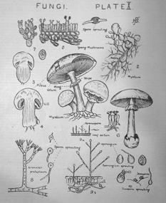
... , Staff at the Summer School, Outside Wilson Hall, Watt's River..., Staff at the Summer School, Outside Wilson Hall, Watt's River ...The Federation University Historical Collection holds a full range of Victoria Education Gazette and Teachers' Aid from 1900-1968.Ten black hard covered volumes with red tape spine, covering 1900 to 1910. The gazettes include Education Department appointments, transfers, resignations and retirements, notices, queries, notices of books, examination papers, original articles, lesson plans, suggestions for lessons, drawing, obituaries, notes on nature study, mathematics, music, sloyd woodwork, English grammar, Victorian State School Swimming Clubs, Geography, penmanship, science, History, Latin, Geography; The School Garden - Shean's Creek .1) Arbour Day (pg 135) Images: Melbourne Teachers' College 1888 Building (p.8); Union Jack (p. 80); Gasometer (p. 132) .2) Plant Life lesson plans, The Antarctic in 1910, Model Nature Lesson - what plants live on , Superannuation Fund, Saluting the Flag, A.N.A. School Children's Competitions, school garden awards, Teacher Training College, Nature Study - A page from a Teacher's Diary, A Mushroom, Mrs Bush's Kindergarten Christmas Images: Dookie Agricultural College, George R. Button, training college students attending the university, Sloyd teachers, Staff at the Summer School, Outside Wilson Hall, Watt's River Weir, Fungi .3) Images: Walhalla State School; Francis W. Parker (p. 18); Freearm Drawing- Sale State School (p.71) .5) Images: Map of Australia (p.33); Formalin lamps for disinfecting rooms (p. 80); Melbourne Teachers Training College (p. 167) .6) Werribee Gorge Supplement (p. 3, 4, 11, 12, 13) .7) First Exhibition of Women's Work (p. 7, 73-76) .8) Images: Franco-British Exhibition; Memorial to William H. Nichols (p. 191) .9) Temperance Teaching; Birds native to Australia (p.4) Images: Royal Agricultural Show State Schools Exhibit (p. 5-18); Leonard's Hill School; Visit of the American Fleet .10) Funeral of Edward VII Images: Portsea Quarantine Station (p. 33-35)w.o. ryan, f. thomas, a.a. tipping, t.n. considine, w.c. fordyce, e.e. bull, h.w. byrne, j.t. flynn, r.t. smith, a.w. steane, james bagge, theo fink, frank tate, siede, nature, garden, education, school, teacher, teaching, arbor day, arbour day -
![Fern Bridge Gully, Black Spur / [by] Nicholas Caire, circa 1876](/media/collectors/550653872162f11fb04854aa/items/577b4c16d0cdd10948c8afab/item-media/577b4c75d0cdd10948c8ebe0/item-fit-380x285.jpg) Kew Historical Society Inc
Kew Historical Society IncPhotograph, Anglo-Australasian Photographic Company, Fern Bridge Gully, Black Spur, c. 1876
... is one of the sources of the River Watt.’... of the River Watt.’ Views of Victoria (General Series), No.22 / ‘Fern ...Nicholas Caire was born on Guernsey in the Channel Islands in 1837. He arrived in Adelaide with his parents in about 1860. In 1867, following photographic journeys in Gippsland, he opened a studio in Adelaide. From 1870 to 1876 he lived and worked in Talbot in Central Victoria. In 1876 he purchased T. F. Chuck's studios in the Royal Arcade Melbourne. In 1885, following the introduction of dry plate photography, he began a series of landscape series, which were commercially successful. As a photographer, he travelled extensively through Victoria, photographing places few of his contemporaries had previously seen. He died in 1918. Reference: Jack Cato, 'Caire, Nicholas John (1837–1918)', Australian Dictionary of Biography.An original, rare photograph from the series 'Views of Victoria: General Series' by the photographer, Nicholas Caire (1837-1918). The series of 60 photographs that comprise the series was issued c. 1876 and reinforced a neo-Romantic view of the Australian landscape to which a growing nationalist movement would respond. Nicholas Caire was active as a photographer in Australia from 1858 until his death in 1918. His vision of the Australian bush and pioneer life had a counterpart in the works of Henry Lawson and other nationalist poets, authors and painters.Views of Victoria (General Series), No.22 / ‘Fern Bridge Gully, Black Spur’ / Albumen silver photograph mounted on boardInscription on reverse: 'Fern Bridge Gully is situated near the summit of the Black Spur, about two miles from Fernshawe. Here the foliage is exceedingly dense, so much so as to exclude daylight in many places. This stream has derived its name from the fact of the Bridge having been constructed of large massive fern tree. The stream which flows beneath the Bridge is one of the sources of the River Watt.’nicholas caire (1837-1918), australia - landscape photography -
![Junction of the River Watt and Contentment Creek / [by] Nicholas Caire, circa 1876](/media/collectors/550653872162f11fb04854aa/items/57760437d0cdd10a5c49fc3e/item-media/57760510d0cdd10a5c4a8f9c/item-fit-380x285.jpg) Kew Historical Society Inc
Kew Historical Society IncPhotograph, Anglo-Australasian Photographic Company, Junction of the River Watt and Contentment Creek, c. 1876
... Junction of the River Watt and Contentment Creek...printed in ink on support l.c.: JUNCTION OF THE RIVER WATT... photography printed in ink on support l.c.: JUNCTION OF THE RIVER WATT ...Nicholas Caire was born on Guernsey in the Channel Islands in 1837. He arrived in Adelaide with his parents in about 1860. In 1867, following photographic journeys in Gippsland, he opened a studio in Adelaide. From 1870 to 1876 he lived and worked in Talbot in Central Victoria. In 1876 he purchased T. F. Chuck's studios in the Royal Arcade Melbourne. In 1885, following the introduction of dry plate photography, he began a series of landscape series, which were commercially successful. As a photographer, he travelled extensively through Victoria, photographing places few of his contemporaries had previously seen. He died in 1918. Reference: Jack Cato, 'Caire, Nicholas John (1837–1918)', Australian Dictionary of Biography.An original, rare photograph from the series 'Views of Victoria: General Series' by the photographer, Nicholas Caire (1837-1918). The series of 60 photographs that comprise the series was issued c. 1876 and reinforced a neo-Romantic view of the Australian landscape to which a growing nationalist movement would respond. Nicholas Caire was active as a photographer in Australia from 1858 until his death in 1918. His vision of the Australian bush and pioneer life had a counterpart in the works of Henry Lawson and other nationalist poets, authors and painters.Albumen Silver Photograph, mounted on Board. printed in ink on support l.c.: JUNCTION OF THE RIVER WATT AND CONTENTMENT CREEK. / COPYRIGHT REGISTERED. printed in ink on support reverse c.: VIEWS OF VICTORIA. / (GENERAL SERIES.) / No. 1. / JUNCTION OF THE RIVER WATT AND CONTENTMENT CREEK. / This scene is situated about two miles to the westward of Fernshawe, a small but extremely romantic township. / The river, at this juncture, is crossed by a fallen tree, as may be seen in the illustration. The track which is seen on / the opposite side of the river leads to the summit of Mt. Munda (3,500 feet high), 4 miles distant, from which place / visitors can see the Australian Alps, in all their mighty grandeur, stretching for hundreds of miles on either side, / and, as far as the eye can reach, impressing a beholder with the appropriateness of their title, being that of the Great Dividing Range. printed in ink on support reverse l.c.l.: J.W. FORBES, Agent, printed in ink on support reverse l.c.: ANGLO-AUSTRALASIAN PHOTOGRAPHIC COMPANY, MELBOURNE. printed in ink on support reverse l.c.r.: 10 Temple Court, Collins Street West.nicholas caire, views of victoria - general series, landscape photography -
 Eltham District Historical Society Inc
Photograph - Digital Photograph, Alan King, Nillumbik Shire Offices, Greensborough, 30 March 2008
... was added to the shire, while the area east of Watts River, near... was added to the shire, while the area east of Watts River, near ...Nillumbik Shire Council transferred to the former Diamond Valley Shire Offices in Greensborough after municipal restructuing. The offices became the official Nillumbik Shire Council Offices on 16 October 1995. The former Shire of Diamond Valley Civic Centre or Shire Office building was officially opened on 26th February 1972. Archtiects were A.K. Lines, McFarlane & Marshall and it was built by L.U. Simon Pty Ltd, The Diamond Valley Shire had been created in 1964 from part of the City of Heidelberg. On December 15, 1994 the Shire of Nillumbik was established. Under the Council amalgamations imposed by the Kennett government, the Shire of Eltham, Shire of Diamond Valley and City of Heidelberg ceased to exist with the establishment of Nillumbik Shire Council and the City of Banyule.The new Nillumbik shire surrended the west riding from Eltham to Banyule but in place gained parts of the former Diamond Valley Shire which itself had been created in 1964 from parts of the City of Heidelberg. Three unelected and non-local Commissioners were put in place by the government bringing democracy into question by many members of the local community. The Commissioners determined to abandon the former Shire of Eltham offices located in Main Road, Eltham and in turn occupy the former Shire of Diamond Valley offices located at the boundary of the new shire with Banyule, in Civic Drive, Greensborough. In July 1996 the Commissioners sold the former Eltham Shire Offices and had them bulldozed leading to many years of communiity protest over the process and future development applications. The site has remained vacant ever since. Published: Nillumbik Now and Then / Marguerite Marshall 2008; photographs Alan King with Marguerite Marshall.; p43 It was the need for roads that led to this district’s first council. In 1853 a committee was formed to improve the rough roads, some in Kangaroo Ground being almost impassable in winter.1 The committee fundraised by voluntary levies and grants to improve in particular, the main road between Kangaroo Ground and the Plenty River. From this committee arose the Eltham District Road Board, in 1856, which was the precursor to the Eltham Shire Council. The Board’s first chairman was Kangaroo Ground farmer, John Barr. Secretary was the former committee’s secretary, Andrew Ross, Kangaroo Ground’s first school teacher, and founder of the district newspaper, The Evelyn Observer.2 Most of the board’s income came from a toll-house north of the Lower Plenty Bridge, which funded such projects as a road from Kangaroo Ground to the Caledonia Diggings. In 1871 the Shire of Eltham was proclaimed, with its boundaries the same as those of the Road Board, and Councillor A Donaldson of Kangaroo Ground was the first president. Eltham was at the southern tip of the shire, which extended north to Kinglake and east beyond Yarra Glen. In 1878, part of Kinglake was added to the shire, while the area east of Watts River, near Healesville was removed. In 1912, then again in 1958, the shire was further reduced. Yarra Glen, Steels Creek, Tarrawarra, parts of Healesville and Christmas Hills, were transferred to the Shire of Healesville. In 1972 a smaller area, at Kinglake, was transferred to the Shire of Yea, leaving 277 square kilometres in the Eltham Shire. Perhaps no other Victorian municipality has had so many meeting places. Although from 1858 to 1904, the council convened at the office in the home of Secretary Charles Wingrove, the board, and later the council, also met at other more central locations.3 The board moved from the Fountain of Friendship Hotel to the Eltham Courthouse, to the Kangaroo Ground schoolhouse. It then met at the Kangaroo Ground Hotel, which some considered put it in danger of interruptions by people ‘the worse for liquor’.4 In 1885 the council met at the hall on Mr J Donaldson’s land at Kangaroo Ground. After Wingrove’s retirement, the council rented space at the Kangaroo Ground General Store and Post Office. Then, in 1917, the council bought the former office of The Evelyn Observer, after its printing works transferred to Hurstbridge. In 1934, fire destroyed the shire office, which was temporarily relocated to the Kangaroo Ground home of Shire Secretary, Mr P J McMahon. In 1941, the shire office moved to a new building (which included a public hall) in Eltham, at the corner of Arthur Street and Main Road, where the Eltham Village Shopping Centre was eventually built. Growth required new offices, which opened in 1965, on the former Shillinglaw property in Main Road.5 In 1994, as part of municipal restructuring under the Jeff Kennett Liberal Government, most of the Eltham Shire formed part of the new Shire of Nillumbik. It joined with the north section of the Diamond Valley Shire and parts of the Healesville and Whittlesea municipalities. The Diamond Valley Shire had been created in 1964, from part of the City of Heidelberg. Turbulence followed Nillumbik Shire’s formation. Under the Commissioners the council transferred to the former Diamond Valley Shire offices in Greensborough, and the Eltham council offices were demolished. In March 1997 the first five-member Nillumbik Council was elected. But, in October 1998, the government suspended the council and appointed an administrator . Early in 1999, shire residents voted to increase councillors to nine: comprising five ward councillors and four shire-wide councillors. Elections were held in March 1999. Then, before the March 2002 elections, nine new wards were created.6 In 2008 these were reduced to seven. Today [2008] the council governs a varied population of more than 60,000 people living in townships and on bush properties in the green wedge.This collection of almost 130 photos about places and people within the Shire of Nillumbik, an urban and rural municipality in Melbourne's north, contributes to an understanding of the history of the Shire. Published in 2008 immediately prior to the Black Saturday bushfires of February 7, 2009, it documents sites that were impacted, and in some cases destroyed by the fires. It includes photographs taken especially for the publication, creating a unique time capsule representing the Shire in the early 21st century. It remains the most recent comprehenesive publication devoted to the Shire's history connecting local residents to the past. nillumbik now and then (marshall-king) collection, greensborough, nillumbik shire council offices, civic drive -
 Federation University Historical Collection
Book, University of Ballarat Research + Innovation Digest
... in computer security, Paul watters * Are our rivers up the creek... in computer security, Paul watters * Are our rivers up the creek ...Black, soft covered book of 48 pages outlining research at the University of Ballarat. Contents include: * Case studies in keeping food safe, Benu Adhikari * technologies that combat climate change - Alberto Boretti *Learning t lead- leading to learn, Neil Trivett * Depression, diabities and motivation, Mirella Di Benedetto * Valuing Lake Wendouree, Julian Lowe * What's in a name, Laura Kostanski * Optimizing Regional & International Research, John Yearwood * Sport, physical activity and health research, Warren Payne * Climate secrets in the sediments, Peter Gell * Injury prevention and saftey promotion research theme, UB Sports injury centre, Caroline Finch, Men's Sheds & other learning places, Barry Golding * New economy, new work, new qualifications, Erica Smith * Cross-cultural communication in a shrinking world, Georgina Tsolidis * Child Protection & family services reform, Angela Murphy * making a difference for older Victorians, Sally Wellard * Making good (and goodly) profits, jackie tuck * Not too much 'ordinary' about Teh Ordinry, Lorraine Sim * Gaming Machines & regional gamblers * Toe nail clippings revel their secrets, Kim Dowling * Magnificently preserved megafaunal trackways in the Victorian volcanic plans, Stephen Carey * A stuttering start for a stunning outcome, Grant Meridith * Supporting patients & their careres, Anthony Love * Out of Africa and beyond, James O'Meara * Taking a hard look to avoid hard knocks, Caroline Finch and Dara Twomey * Skilling people for business success, Andy Smith * Promoting risk awareness in industry, David Borys * researching China's Rise & Rise, Mike Willis *Sex hormones link to heart disease, Fadi Charchar * Human factors in computer security, Paul watters * Are our rivers up the creek, Peter Gell * Women as managers7 entrepreneurs, Glenice Wood * Revisoning values and norms, Jane Mummery * 'Wimmera" - an epic Poem, Homer Rieth * Recycling, consumerism, climate change and art peactice, marie Purtill * Investing in ecologically sustainable development, Jerry Coursisanos * Indigenous peoples of the goldfields, Fred Cahir * Artists install images of sustainability, Jill Orr * addresing disadvantage& inequality with passion, John Smyth * Breaking up insulin haxamers, Mark Myersaborigines, mens shed, wimmera, gambling, megafauna, gell, golding, carey, cahir, purtill -
 Orbost & District Historical Society
black and white photograph, August 1897
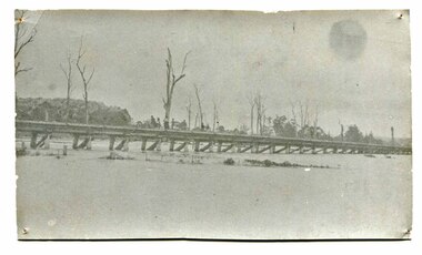
This is a photograph of the bridge from the Orbost side. The first pile bridge over the Snowy River was just completed by Mr Jim Granter when the 1891 flood took out the centre,. There were differences of opinion as to whether the council should pay . The Shire Secretary, Mr John Draffin, persuaded them to honour their obligations. Mr Granter and Mr Clarke finished it as a suspension bridge which was opened by Mrs William Watt. Soon after a mob of cattle stampeded, the weight snapped the cable, letting one side sag. Mr R.P. Cameron repaired it and this bridge remained until 1922. "In 1890 the contract for a bridge was let to Mr James Granter for £1450. This structure with additions and improvements made to it was to cost the ratepayers about £2,500, and its erection was proceeded with in a very satisfactory manner until, just as the greater-part of the work had been completed, the flood of 1891 came down on it, piling up mountains of logs, timber and debris against the piers, which had not been made wide enough apart to allow for. contingencies of this kind. The structure held out bravely until the turn of the flood and then gave way with a crash, about five bays from the centre disappearing in the stream." ( Snowy River Mail August 12 1893) This item is a pictorial record of one of the first bridges across the Snowy River in Orbost.A black / white photograph of the old wooden suspension bridge over the Snowy River. There are two copies 919.1 and 919.2. There are two other photos showing the whole bridge taken from further back.on back - "Orbost Bridge...."snowy-river-bridge-orbost granter-james -
 Orbost & District Historical Society
black and white photograph, January 1934
Orbost has been subject to major floods throughout its history, such as those which left the town isolated in 1934, 1952, 1971 and 1978. It is recorded that the Snowy River broke its banks and flooded the flats 104 times between 1884 and 1978. Extensive flooding in Eastern Victoria during June 1978, caused widespread damage to roads, road closures and hazards to traffic, particularly over the Queen's Birthday holiday weekend.This is a pictorial record of a significant event in Orbost's history.A very faded black / white photograph of flood water under the railway viaduct at watt's Gulch.orbost-flood-1934 railway-viaduct-orbost -
 Orbost & District Historical Society
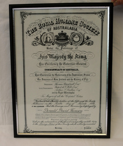
certificate/award, after 1934
This certificate was presented to Donald David Thomson , sleeper hewer, aged 42 years for rescuing S.C. Curtis, aged 52, G. Wylie, aged 54, J. Dalgleish, aged 5 from flood waters at White gulch on the Snowy River on January 8, 1934. (The certificate reads as White's Gulch but should be Watt's gulch.) Although damage estimated at 500,000 pounds was caused by the unprecedented floods along the Snowy River, no lives were lost because of the courageous actions of men like Donald Thomson.A framed copy of a printed and hand-written certificate from the Royal Humane Society of Australia awarded to Donald David Thomson for rescuing victims of the floodwaters in Orbost January 1934. It is dated 6.3.1934.Printed at top of certificate: THE ROYAL HUMANE SOCIETY / OF AUSTRALASIA. Has names of Society patrons and committee as well as names and ages of those rescued. award certificate royal-humane-society flood snowy-river 1934 thomson-david -
 Orbost & District Historical Society
black and white photograph, C1890
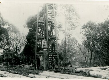
This photograph shows the construction of the first bridge over the Snowy River at Orbost being built. a copy was also donated by Gil and Heather Richardson. The first pile bridge over the Snowy River was just completed by Mr Jim Granter when the 1891 flood took out the centre,. There were differences of opinion as to whether the council should pay . The Shire Secretary, Mr John Draffin, persuaded them to honour their obligations. Mr Granter and Mr Clarke finished it as a suspension bridge which was opened by Mrs William Watt. Soon after a mob of cattle stampeded, the weight snapped the cable, letting one side sag. Mr R.P. Cameron repaired it and this bridge remained until 1922. "In 1890 the contract for a bridge was let to Mr James Granter for £1450. This structure with additions and improvements made to it was to cost the ratepayers about £2,500, and its erection was proceeded with in a very satisfactory manner until, just as the greater-part of the work had been completed, the flood of 1891 came down on it, piling up mountains of logs, timber and debris against the piers, which had not been made wide enough apart to allow for. contingencies of this kind. The structure held out bravely until the turn of the flood and then gave way with a crash, about five bays from the centre disappearing in the stream." ( Snowy River Mail August 12 1893)This is a pictorial record of the construction of the first bridge over the Snowy River.A black / white photograph of four men working on the construction of a new bridge and its pylons a man is standing on a timber tower/ derrick. There are logs in the foreground, trees in the background. sheds on the left and possibly a steam engine.on back - "first bridge - 1st pile being driven"snowy-river-bridge granter-jim bridge -
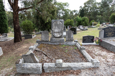 Eltham District Historical Society Inc
Photograph, Peter Pidgeon, Grave of (Captain) Gordon Watts-Phillips and Mary Hilda Watts-Phillips, Eltham Cemetery, Victoria, 5 April 2021
Charles Gordon Watts-Phillips was born in 1849 at Forest Hill, Surrey, England, the son of Dramatic Author, Watts Phillips, and Lily Mariner. He departed England for Australia around 1874. His sister Roland was a favourite Australian actress of the early 1900s. Gordon as he was known, whilst residing in Goolwa, South Australia and working as a clerk met and married a widow, Jane Luxon (nee Miller) on the 7th August, 1876 at the Wesleyan Church in Strathalbyn, South Australia. Jane, Gordon’s elder by some 11 years was born in Ireland in 1838, the daughter of Robert Joseph Miller, a carpenter and Jane Miller. She had previously married Captain William Luxon in 1861 at Encounter Bay, South Australia at age 22 and they had four children: William (1864), George Robert (1865), Miriam Louisa (1867) and Harriet Jane (1869), all born at Encounter Bay. Gordon and Jane had two further children together: Caroline Roland Watts-Phillips (1877 Islington S.A.) and Charles Gordon Watts-Phillips (1879 Yatala, S.A.). At some stage, Jane then deserted her husband. Gordon obtained a master's certificate and was a part owner of a small trader. He had also been captain of one of the passenger boats on the Darling River. He was reputedly a popular coastal skipper. By 1891 Gordon was the Captain of the S.S Omeo operating around Sale, Victoria. In August of that year some of the heaviest flooding of the Thomson River ever experienced in twenty years occurred over the 3rd and 4th of August. Gordon, and others, rescued the lives of many families over that period for which he was awarded a Bronze Medal by the Royal Humane Society. By 1892 the S.S. Omeo had passed to another Captain and Gordon subsequently retired from the sea and moved to Melbourne. Whilst residing in Coburg, Victoria, Gordon met Mary Hilda Harvey Huxley who was living in Brunswick. Mary was born in Horsham, the daughter of George Harry Huxley, a miner, and Emma Deane. Having not heard from Jane for some years and believing her dead, Gordon and Mary marry at Carlton on Christmas Eve, 1900. Interestingly, an announcement of the marriage was not placed in The Age newspaper until September 1903, nearly three years after the event by which time Gordon and Mary had a son, Victor Gordon Watts-Phillips, born 8 February 1903 in Carlton. Within months of the placement of this marriage announcement, his former wife, Jane, makes a reappearance but apparently does not interfere and Mary and Gordon continue to live together as husband and wife. Around the same time in late 1903, Gordon’s brother, Basil Watts Phillip wrote from London to the Victoria Police seeking assistance to locate his brother. He had last heard from him in a letter dated Cunninghame, Gippsland, 1891. He indicated that about 1893 Gordon and Jane and their two children were living at Beaconsfield Parade, Albert Park but the whereabouts of all was now unknown. He mentioned Gordon had also been awarded 21 guineas by Judge Boucaut on the 26th February 1884, also a silver medal, for arresting two ruffians who had brutally assaulted a jockey (in South Australia) and that he had been awarded the Royal Humane Society's medal, London, and in 1891, was presented with the Royal Humane Society's certificate of merit (Victoria). Basil also stated his brother had lost the sight of one eye through a stab he received in New York and had a scar on his temple, one on the wrist, two under the shoulder blade, and one on the thigh, and two bullet wounds in the leg. Basil’s quest was published in the Melbourne Herald and assistance was soon forthcoming to the Police. In June 1906 Gordon made his Will, leaving all his estate to his youngest son Victor. Mary was appointed Executrix and it was witnessed by Olive Huxley, married woman, and James Huxley, a pottery maker. James was subsequently killed in France in May 1918. Gordon and Mary have a second son, Basil Douglas born in Carlton in 1911 but he dies as toddler in 1913. At some point Gordon and Mary made their home at Eltham though official electoral roll records record them at Little Flinders Street Melbourne, employed as a caretaker and from 1906 in Brunswick as a decorator then painter. Eltham may have been a ‘holiday’ home but it seems Mary was actively engaged in the community as a newspaper report in the Advertiser in 1922 not long after Gordon’s death indicates Mary was one of the best known and best liked ladies of the Eltham district. She was actively engaged in all matters, tending towards the welfare of the district. At the time of Gordon’s death Mary was president of the Ladies' Public Hall Committee, responsible for the conduct of numerous, and successful entertainments. Gordon’s first and only legal wife, Jane Luxon Watts-Phillips nee Miller, died 6 November 1921 and was buried 8 November 1921 at Springvale Cemetery. Jane had lived 34 years in South Australia and 30 years in Victoria. With Jane now dead, Gordon was now officially a widower and just three weeks later, the retired master mariner of Eltham at age 55 remarried Mary, 42, of 174 Hickford Street, East Brunswick on the 29th November 1921 in the Parish of St Cuthbert, East Brunswick. Gordon died at their home, ‘The Rest’, at 174 Hickford Street, East Brunswick on February 9, 1922 and was buried at Eltham Cemetery on February 11. An interesting link is established with the heavy floods of August 1891 by the erection of a tombstone in the Eltham cemetery. The stone bears the inscription: - “In loving memory of (Captain) Gordon, dearly beloved husband of Mary Watts Phillips. Died 9th February 1922, aged 62 years." Beside the stone is a replica, carved in a marble scroll, of the Royal Humane Society of Australia's Certificate of merit. Part of the wording of this certificate is as follows:- “At a general court of directors holder at the offices of the society at Melbourne on the 6th day of September 1891, it was resolved that the courage and humanity displayed by Gordon Watts Phillips aged 30-years captain of S.S. Omeo, Sale, in rescuing many families from drowning during the heavy floods on Thomson River on 3rd and 4th of August 1891 call for the admiration of the court, and justly entitles him to the certificate of merit of this society, which is hereby awarded." Unbeknownst to Gordon, his second and subsequent legal marriage to Mary initiated a revocation of his Will of 1906, which had solely benefited his son Victor. Consequently, Mary had to apply for Letters of Administration and the only legal beneficiaries would be Mary and his two children by Jane. On June 18, 1940, at age 61, Mary married 70-year-old Arthur Ernest Fenn in Melbourne. Unfortunately for her, Arthur died a year later in July 1941 and was buried in the Cohuna Cemetery near Echuca. Mary lived a further 8 years, passing away suddenly July 4, 1948 in Carlton, and was buried July 7 with her beloved husband Gordon, at Eltham Cemetery. In Loving Memory of (Captain) Gordon Dearly beloved husbandof Mary Watts-Phillips Died 9th Feb. 1922, aged 62 years Also Mary Hilda Loved wife of above Died 4th July 1948 "At rest"Born Digitaleltham cemetery, gravestones, (captain) gordon watts-phillips, mary hilda harvey watts-phillips (nee huxley) -
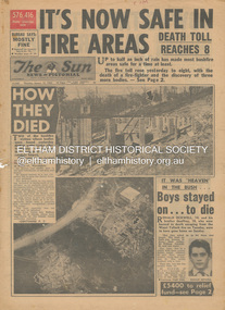 Eltham District Historical Society Inc
Newspaper - Newspaper articles, Sun News-Pictorial, It's Now Safe in Fire Areas; Death Toll Reacxhes 8, The Sun News-Pictorial, Thursday, January 18, p1, 1962
Various news articles pertaining to the January 1962 Victorian bushfires in the Dandenong and Healesville districts which by the third day had encompassed large areas of the State. Specific Eltham Shire districts mentioned include Warrandyte on page 1, St. Andrews and Smith’s Gully on page 2, St. Andrews on page 3 and 43, Panton Hill and Warrandyte on p23 and Hurstbridge on page 44 • It's Now Safe in Fire Areas; Death Toll Reaches 8, p1 (Illust.) • How they died, pp1-2 • It was “heaven” in the bush … Boys stayed on . . . to die, pp1-2 (Illust.) • Towns take stock as danger drops, p2 • £5400 to the relief fund, p2 • Fire now threat to Otways, p2 • Pensioners lose all, p2 • “…If Only The Rain Had Come” … and then it came to town, p3 (Illust.) • Our best rain since May • It halted at Grandma’s front gate, p5 (Illust.) • Now that the rain has come; It’s time for the clean-up, p6 • Wisps of smoke where flames danced, p7 • Charitry’s a loser, p7 • War Service homes claim, p7 • Help’s on way, p7 (Illust.) • Came with their gifts …, p7 • Fire summons for youth; “sparked the rest”, p9 • Three gaoled, p9 • They had to camp out at Wye River, p9 (Illust.) • “Probe Fires” – Stoneham, p9 • The Fourth Day: Scorched Earth!, pp22-23 (Illust.) • This home was saved but - , p22 (Illust.) • Relief Centre, p23 (Illust.) • Homeless, p23 (Illust.) • So little was left, p43 (Illust.) • Tommy saved his cat, p43 (Illust.) • Some were lucky … and some were tired, p44 (Illust.) tom fielding collection, victorian bushfires - 1962, victorian bushfires – 1962, ronald ockwell, geoffrey ockwell, woori yallock, william ockwell, leslie ockwell, linda may ockwell, black friday, victorian bushfires – 1939, warrandyte, arthur brown, harold vernon betton, bloom road, william smith, olinda, bushfire relief fund, yarra glen, healesville, railway line, st. andrews, smith’s gully, otway ranges, eric watts, edith varty, inverness road, mt. evelyn, wye river, panton hil, heather sullivan, warrandyte hall, montrose, kalorama, mrs e. tucker, shirley tucker, margaret tucker, joane tucker, roger tucker, trevor tucker, ann quinton, tom dunstan, hurstbridge hall -
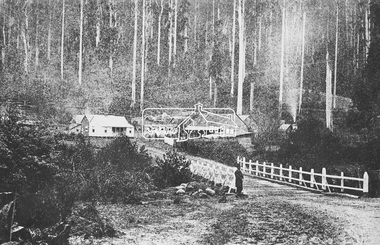 Eltham District Historical Society Inc
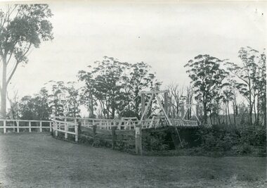
Photograph, M.Jefferson, Watts Bridge Hotel, Fernshaw, Vic
... , Shire of Eltham Pioneers Photograph Collection, Watt's River ...Source: National Library, Canberra from Album of Victorian Views, photographed by C. Nettleton This photo forms part of a collection of photographs gathered by the Shire of Eltham for their centenary project book,"Pioneers and Painters: 100 years of the Shire of Eltham" by Alan Marshall (1971). The collection of over 500 images is held in partnership between Eltham District Historical Society and Yarra Plenty Regional Library (Eltham Library) and is now formally known as the 'The Shire of Eltham Pioneers Photograph Collection.' It is significant in being the first community sourced collection representing the places and people of the Shire's first one hundred years.Digital imagefernshaw, other areas, sepp, shire of eltham pioneers photograph collection, watt's river -
 Marysville & District Historical Society
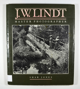
Book - Hardcover book, J.W. Lindt Master Photographer, 1985
... and Watts River area and he sold over 25,000 images of the Black ...A book of photographs taken by John William Lindt of locations and scenery throughout the world.A book of photographs taken by John William Lindt of locations and scenery throughout the world. John William Lindt (1845–1926), was a German-born Australian landscape and ethnographic photographer, early photojournalist, and portraitist. John Lindt was responsible for a folio of photographs of the Fernshaw and Watts River area and he sold over 25,000 images of the Black Spur from his original negatives. In 1895 he was able to purchase land on the North East side of the Black Spur and subsequently built his home and guesthouse "The Hermitage" from where he continued his photographic career. In 1913 he collaborated with Nicholas Caire to produce a tourist booklet on the area. In 1925 the Argus reported that Lindt "continues to produce remarkable and most artistic pictures of the beauties of mountain landscape. He is not a believer in the blurred effects favoured by many ... instead he is a master of detail." Aged 81 Lindt died of heart failure during disastrous bushfires on 19 February 1926 at the Hermitage. He was survived by his wife Catherine who continued to run ‘The Hermitage’ guest house before she retired to the city.Hardcover. Front cover photograph-Log Bridge at the Hermitage c1910photography, artistic, john william lindt, la trobe collection, shar jones -
 Marysville & District Historical Society
Book - Hardcover book, J.W. Lindt Master Photographer, 1985
... and Watts River area and he sold over 25,000 images of the Black ...A book of photographs taken by John William Lindt of locations and scenery throughout the world.A book of photographs taken by John William Lindt of locations and scenery throughout the world. John William Lindt (1845–1926), was a German-born Australian landscape and ethnographic photographer, early photojournalist, and portraitist. John Lindt was responsible for a folio of photographs of the Fernshaw and Watts River area and he sold over 25,000 images of the Black Spur from his original negatives. In 1895 he was able to purchase land on the North East side of the Black Spur and subsequently built his home and guesthouse "The Hermitage" from where he continued his photographic career. In 1913 he collaborated with Nicholas Caire to produce a tourist booklet on the area. In 1925 the Argus reported that Lindt "continues to produce remarkable and most artistic pictures of the beauties of mountain landscape. He is not a believer in the blurred effects favoured by many ... instead he is a master of detail." Aged 81 Lindt died of heart failure during disastrous bushfires on 19 February 1926 at the Hermitage. He was survived by his wife Catherine who continued to run ‘The Hermitage’ guest house before she retired to the city.Hardcover. Front cover photograph-Log Bridge at the Hermitage c1910photography, artistic, john william lindt, la trobe collection, shar jones -
 Greensborough Historical Society
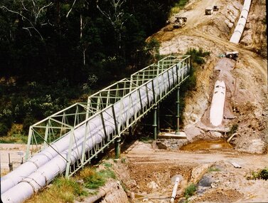
Photograph - Digital image, New pipeline replacing Watts Reservoir aqueduct, 1977_
Photograph of new aqueduct pipe near Plenty River Greensborough.Digital copy of colour photograph.aqueduct, maroondah aqueduct, plenty river -
 Greensborough Historical Society
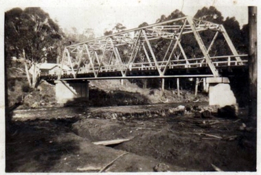
Photograph - Digital Image, Pipes over Plenty, construction of original bridge for Watts Reservoir aqueduct, 1950-1970
Photograph of the Maroondah aqueduct bridge over the Plenty River in Greensborough.Digital copy of black and white photograph.maroondah aqueduct, aqueduct, plenty river