Showing 1946 items matching " flooding"
-
 Wonga Park Community Cottage History Group
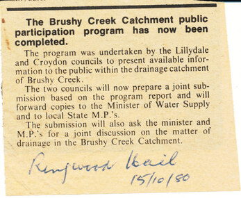
Newspaper (Item) - Photocopy Newspaper Cutting, Brushy Creek Catchment Ringwood Mail 15/10/1980
Discussion by City of Croydon and Shire of Lillydale re matter of drainage in Brushy Creek Catchment later resulting in flood retainment scheme and levy -
 Charlton Golden Grains Museum Inc
Photograph
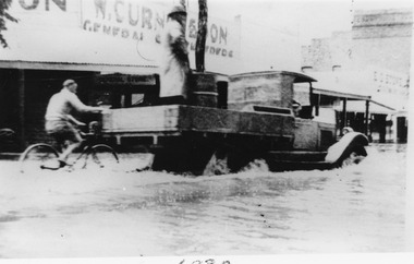
Flooded High Street with Ute driving through. A person on a bike holds onto the Ute tray. The store in the background is W. Curnow and sons. Black and white photograph unframed.flood, charlton, high street, w. curnow & son -
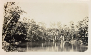
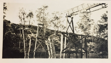
 Orbost & District Historical Society
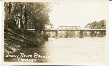
black and white photograph, 1971
This photograph shows the second major bridge across the Snowy River at Orbost. The current Snowy River bridge is the fourth to provide a crossing to the township of Orbost. The first, in 1891, lasted just two years before it succumbed to flood waters. The bridge in this photograph was built in the 1920s as a road and rail bridge, and was again partly washed away by flood waters in 1934. After the end of the first World War the Victorian Railways considered an extension of the railhead across the river at Orbost, and in 1922 a new timber and steel girder structure, a joint Country Roads Board — Victorian Railways venture, was built and completed at a cost of £41,000 (the steel girders came from the Flinders Street viaduct reconstruction). Subsequently it was decided not to take the railway across the river, and the bridge was only used by road traffic. It was severely battered by floods during its life. and after the devastating 1971 floods was eventually replaced by the current bridge in 1975. (info from Newletter 54N by John Phillips)This is a pictorial record of the flood damage in 1971 when part of the Snowy River Bridge was washed away.A black / white photograph of a bridge which has been damaged by floodwaters. It shows one end has been washed away.orbost-snowy-river-bridge-1971 floods-orbost-1971 -
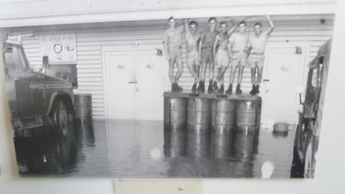 National Vietnam Veterans Museum (NVVM)
Photograph, the Wet, 5/12/1970 12:00:00 AM
Unframed photo - Staff of air movements section No1 Operational Support Unit RAAF flooded out of thei section by monsoon/ L-R Corporal John Hawkes, Sgt Ron Phelps, Corporal Alan Rohde. 11 Movement Control Group, Royal Australian Engineers. Leading Aircraftman Paul DisherAWM VN70-57-1 (2)monsoon floods, no1 operational support unit raaf, air movements section, vung tau -
 Clunes Museum
Document - CORRESPONDENCE, 22/07/1971
TYPED LETTER DATED JULY 22ND 1971 FROM JEAN PEART HON. SEC. OF THE BACK TO CLUNES COMMITTEE 1972. REQUESTING PERMISSION FROM MR. R. PRYOR, SHIRE SECRETARY TALBOT AND CLUNES SHIRE, TALBOT TO INSTALL TEMPORARY LIGHTING AND FLOOD LIGHTING FOR THE TOWN HALL BUTLDING DURING THE "BACK TO" EVENT HANDWRITTEN IN PENCIL "Tool McLennan Write to S.E.C. illegible" local history, document, letters, events and celebrations, back to clunes -
 Bendigo Historical Society Inc.
Article - JOHN WILLIAMS COLLECTION: NEWSPAPER ARTICLE BENDIGO LINK TOUR CYCLING, 2000s
JOHN WILLIAMS COLLECTION: Newspaper Article Bendigo Link Tour Cycling Newspaper article about Quarry Hill State School Teacher John Williams, three of his students and fathers and their links to the Herald Sun Tours. Photo of the three students, Tyson McCaig, Jack Flood and Nick Crome behind a bicycle. -
 Bendigo Military Museum
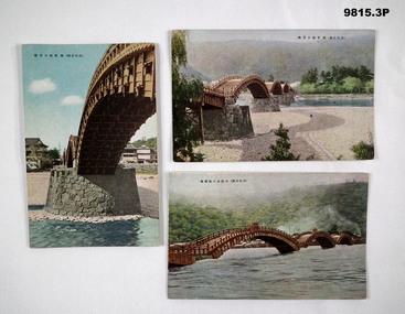
Postcard - POSTCARD, JAPAN, SHUEIDO
Part of the Bennetts Collection. See Catalogue No. 9726P for details of service for "Alva Marie Bennetts".1. Colour postcard featuring a span of a wooden bridge. Stone pillar supporting span. Caption in Japanese. 2. Colour postcard featuring a view of four spans of a wooden bridge. River visible. Caption in Japanese. 3. Colour postcard featuring three spans of a wooden bridge. River in flood. Caption in Japanese.bennetts collection, alva bennetts, postcards, japan -
 Orbost & District Historical Society
black and white photograph, first half 20th century
This is a photograph of the second Snowy River Bridge at Orbost. The section in the central span could have been built after flood damage. This bridge over the Snowy River was opened on July 4 1922. It was constructed in 1922 alongside the previous suspension bridge. Its building was a combined effort of the Victorian Railways and the Country Roads Board at a cost of 35,000 pounds. It was replaced in 1976 by the present bridge after several major floods.This bridge was replaced in 1976 after several major floods.A black / white photograph / postcard of a bridge over a river. It has what looks like a bo girder in the central section. On the left is the river bank.on front bottom left - "SNOWY RIVER BRIDGE"orbost snowy-river-bridge transport-bridge -
 Kew Historical Society Inc
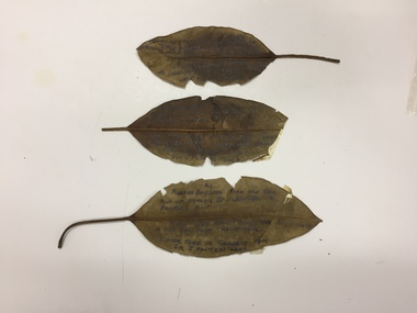
Plant specimen, Dorothy Rogers, Inscribed Moreton Bay Fig Leaves, Hawthorn (Vic), c.1960s
Collected by the historian Dorothy RogersDried Moreton Bay fig leaves from the vicinity of Palmer's Punt near Denham Street Hawthorn. Each leaf was inscribed by the historian Dorothy Rogers (sic) before 1973. The leaves are brittle and undated, with the text difficult to decipher. 1974.0010.1 "Moreton Bay fig leaf from old tree foot of Derham St Haw - vicinity Palmer's Punt until 1934 flood & hut for Punt passengers was still there. KH-355." 1974.0010.2 "Moreton Bay fig leaf from old tree foot of Denham St haw - vicinity Palmer's Punt until 1934 flood hut for punt passengers still existed there. A canoe tree in garden from Sir J. Palmer's land. KH-355." 1974.0010.3 "Moreton Bay fig leaf from old tree foot of Denham St leading to Palmer's Punt until 1934 flood there was still there a hut for punt passengers. Canoe tree in gardens from Sir J. Palmer's land. KH-355."denham street - hawthorn (vic), palmer's punt, invergowrie - hawthorn, 1934 flood - melbourne - hawthorn (vic) -
 University of Melbourne, Burnley Campus Archives
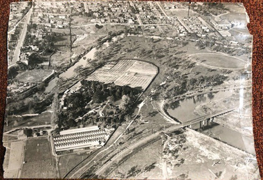
Photograph - Black and white print, Airspy, Aerial View of Burnley Campus c. 1930, c. 1930
Taken before the Boulevard was built, and probably before the flood of 1934. Therefore probably 1929-1934. Information provided by TH Kneen and EB LittlejohnColour photograph of black and white photograph. Photograph of Burnley Campus and large area of surrounding suburbs of Hawthorn and Toorak. It shows the Carter Oval, later modified, the Plant Research Institute (built 1929) and the Box Thorn Hedge (Lycium ferrocissimum).burnley campus, suburbs, hawthorn, toorak, carter oval, plant research institute, boxthorn hedge, lycium ferrocissimum -
 Kew Historical Society Inc
Photograph - Demolishing the Zig-Zag Bridge, 1929
Henry Beater Christian (1886-1962) , was a descendant of one of the earliest settler families in Kew. Employed at the Kew Asylum as a 'public servant', he was a skilled amateur photographer, photographing numerous scenes in Kew and on his travels around Victoria. The majority of his photographs date from 1916 to 1929. His finest photographs are housed in two photograph albums. Rare photograph of the demolition of the Zig-Zag Bridge linking the two asylums on either side of the Yarra River.Digital copy of a photograph from page 16 of the 47-page photograph album containing 261 gelatinous silver images, loaned by Diane Washfold with permission given to digitise and hold a copy in our collection. The Zig-Zag Bridge linked the grounds of the Yarra Bend and Kew Asylums. The wooden bridge was constructed in the 1870s and lasted through numerous floods until its destruction in 1929. A horizontal structure, the walkway was reached via a wooden staircase on the Kew bank of the river. The steps were required due to the different levels of the banks on this stretch of the river. This is a photo of the bridge showing the level of destruction caused by the initial damage from the flood and subsequent dismantling of the horizontal struts and walkway, prior to to its destruction by fire."Demolishing Zig-Zag / 6. 1929"henry beater christian (1886-1962), landscape photography, kew (vic.) — yarra river, christian-washfold collection, photograph albums, zig-zag bridge -
 Kew Historical Society Inc
Photograph - Demolishing the Zig-Zag Bridge, 1929
Henry Beater Christian (1886-1962) , was a descendant of one of the earliest settler families in Kew. Employed at the Kew Asylum as a 'public servant', he was a skilled amateur photographer, photographing numerous scenes in Kew and on his travels around Victoria. The majority of his photographs date from 1916 to 1929. His finest photographs are housed in two photograph albums. Rare photograph of the demolition of the Zig-Zag Bridge linking the two asylums on either side of the Yarra River.Digital copy of a photograph from page 16 of the 47-page photograph album containing 261 gelatinous silver images, loaned by Diane Washfold with permission given to digitise and hold a copy in our collection. The Zig-Zag Bridge linked the grounds of the Yarra Bend and Kew Asylums. The wooden bridge was constructed in the 1870s and lasted through numerous floods until its destruction in 1929. A horizontal structure, the walkway was reached via a wooden staircase on the Kew bank of the river. The steps were required due to the different levels of the banks on this stretch of the river. This is a closeup view of the bridge showing the level of destruction caused by the initial damage from the flood and subsequent dismantling of the horizontal struts and walkway, prior to to its destruction by fire."Demolishing Zig-Zag / 6. 1929"henry beater christian (1886-1962), landscape photography, kew (vic.) — yarra river, christian-washfold collection, photograph albums, zig-zag bridge -
 Kew Historical Society Inc
Photograph - Demolishing the Zig-Zag Bridge, 1929
Henry Beater Christian (1886-1962) , was a descendant of one of the earliest settler families in Kew. Employed at the Kew Asylum as a 'public servant', he was a skilled amateur photographer, photographing numerous scenes in Kew and on his travels around Victoria. The majority of his photographs date from 1916 to 1929. His finest photographs are housed in two photograph albums. Rare photograph of the demolition of the Zig-Zag Bridge linking the two asylums on either side of the Yarra River.Digital copy of a photograph from page 16 of the 47-page photograph album containing 261 gelatinous silver images, loaned by Diane Washfold with permission given to digitise and hold a copy in our collection. The Zig-Zag Bridge linked the grounds of the Yarra Bend and Kew Asylums. The wooden bridge was constructed in the 1870s and lasted through numerous floods until its destruction in 1929. A horizontal structure, the walkway was reached via a wooden staircase on the Kew bank of the river. The steps were required due to the different levels of the banks on this stretch of the river. This is a view of the bridge showing the level of destruction caused by the initial damage from the flood, the subsequent dismantling of the horizontal struts and walkway, and the setting on fire of the remaining structure."Demolishing Zig-Zag / 6. 1929"henry beater christian (1886-1962), landscape photography, kew (vic.) — yarra river, christian-washfold collection, photograph albums, zig-zag bridge -
 Eltham District Historical Society Inc
Negative - Photograph, J.A. McDonald, Eltham, Haldane Road, Mar. 1961
Dr Donald Thomson's gate and entrance to his property 'Worlingworth' after flooding in March 1961 "Worlingworth", Eltham, was the home of noted anthropologist the late Professor Donald Thomson and his wife Dorita. The entrance gate on Banoon Road is located at the bottom of the hill opposite Haldane Road. The flooding issues were regularly reported to Council following heavy rain. Google Street View Feb 2014 https://goo.gl/maps/SGjsJAAEdjQXgo5V9Record of various Shire of Eltham infrastructure works undertaken during the period of 1952-1962 involving bridge and road reconstruction projects, sometimes with Eltham Shire Council Project Reference numbers quoted. It was during this period that a number of significant improvements were made to roads and new bridges constructed within the shire that remain in place as of present day (2022). In many situations, the photos provide a tangible visible record of infrastructure that existed throughout the early days of the Shire. The album was put together by or under the direction of the Shire Engineer, J.A. McDonald.infrastructure, shire of eltham, 1961-03, flood damage, haldane road, prof donald thomson, worlingworth -
 Ballarat Heritage Services
Photograph - Photograph - Colour, Corner of Vickers Street and Albert Street, Sebastopol, 2020, 07/04/2020
The South Star Mine commenced operations in the 1880s and worke the quartz laods after the great floods of 1875 forced the closure of most alluvial mines. The South Star Mine sunk its first shaft in 1886, but broke into old alluvial workings and had to be abandoned because of flooding. The second shaft commenced in 1887, and was the deepest eer sunk in the Ballarat district, reaching 956 metres. 180 men worked three shifts each day.Colour photograph of the site of the South Star Mine in Sebastopol. sebastopol, albert street, south star mine, mining -
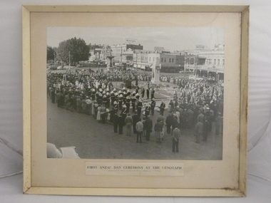 Bendigo Historical Society Inc.
Photograph - PHOTO OF FIRST ANZAC DAY CEREMONY AT THE CENOTAPH, c-1950
Crowd of people around Cenotaph, Bendigo. Brass band with white hats. Clan McLeod pipe band. Army personnel. Beehive store. City Club. CTA Hotel. Myers Store. Markings/Inscriptions: First Anzac Day Ceremony at the Cenotaph. Presented to Sir George Lansell by the Mayor of Bendigo. Cr. T.R. Flood.place, bendigo, anzac day ceremony at cenotaph -
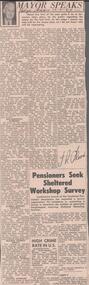 Bendigo Historical Society Inc.
Newspaper - ALBERT RICHARDSON COLLECTION: THE MAYOR SPEAKS: MINE SITES
Newspaper article 'The Mayor Speaks' dated 12th August 1967, Bendigo Advertiser. Article by J.R. Flood. Mayor of Bendigo, detailing the location of mines including the Duchess of Edinburgh on the New Chum line, the mines on the Christmas line of reef, the Deborah reef mines, and the Sheepshead reef. Mine reclamation schemes are also addressed in the articlebendigo, mining, reef lines and mines -
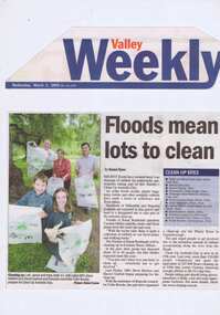 Greensborough Historical Society
Newspaper Clipping - Digital Image, Barak Bushland Reserve - Floods mean a lot to clean, 02/03/2005
Receding flood water levels have revealed much rubbish. Clean Up Australia day volunteers work throughout Banyule and Nillumbik to collect the rubbish.Newspaper clipping, black and white text and colour image.clean up australia day, plenty river -
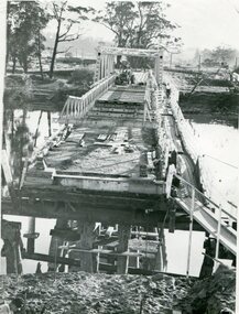
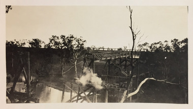
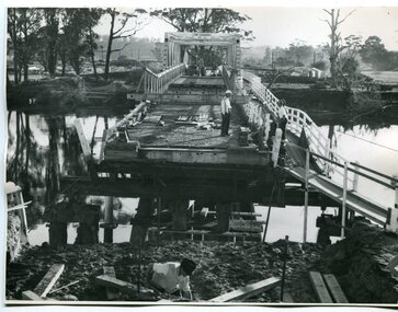 Orbost & District Historical Society
black and white photographs, February 17 1971
After the damage from the February 1971 floods at Orbost when the abutment to the Snowy River road bridge was washed away a Bailey bridge, portable, pre-fabricated, truss bridge, was put into place to ensure town access, the C.R.B. rebuilt the approach to the bridge driving new piles and constructing the Bailey bridge. They worked late into the night under flood lights to ensure the link from the Orbost township to the Princes Freeway would be open to traffic as soon as possible.These photographs are pictorial records of a significant event in the history of Orbost.Three black / white photographs of a Bailey bridge being erected across a river. 3245.1 and 3245.2 are the same. bailey-bridge orbost-snowy-river-bridge bridge-orbost -
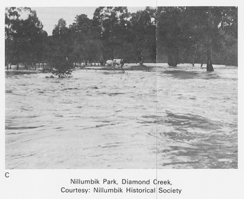 Eltham District Historical Society Inc
Work on paper (Sub-Item) - Photograph, Nillumbik Park, Diamond Creek
Undated black and white photograph of the Diamond Creek in flood, Nillumbik Park, Diamond Creek. Cattle take refuge on a high point. Nillumbik Historical Society collectionflood, diamond creek, nillumbik historical society -
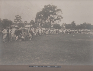 Bendigo Historical Society Inc.
Photograph - LOONG, CHINESE DRAGON, c1920s
Black and white photograph, with some hand colouring. Photo of Chinese dragon 'Loong' all in photo appear to be of Chinese appearance a couple of ornaments and a couple of people have been hand tinted. At 'Bendigo Showground' now known as 'Tom Flood Centre'. Markings/Inscriptions: Chinese Dragon 'Loong', on back; sticker Bendigo Historical Societyorganization, club/society, chinese society, event -
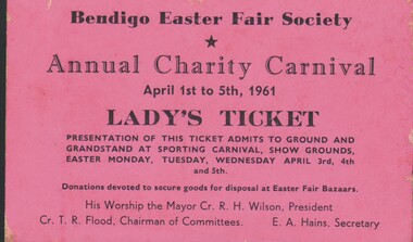 Bendigo Historical Society Inc.
Document - TICKET TO ANNUAL CHARITY CARNIVAL (LADY'S TICKET), 1961
Ticket to Annual Charity Carnival (Lady's Ticket). Bendigo Easter Fair Society, April 1st - 5th, 1961. Admission to grounds and grandstand, Show Grounds. Cr.T R Flood (Chairman of Committee); E A Hains (Secretary). On reverse:Printed number - 208; handwritten: Lemonade 11/- doz. Flavouring 3/2 Orange etc 16/6organization, club/society, bendigo easter fair society -
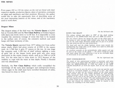 Bendigo Historical Society Inc.
Document - LONG GULLY HISTORY GROUP COLLECTION: DESCRIPTION OF PHOTOS
Page titled The Mines. It has the description of the two black and white photos. Down the Shaft is on the left-hand side and Deep Underground is on the right-hand side. Also on the page is some information on the Deepest Mines. Mentioned are the Victoria Quartz of 4,593 feet and closed in 1913 because of flooding. The New Chum Railway of 4.138 feet closed in 1910.bendigo, history, long gully history group, the long gully history group - description of photos, hercules, shenandoah, new chum railway, victoria quartz -
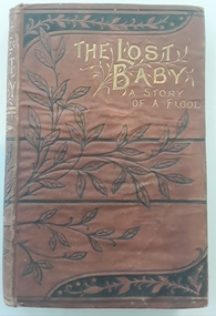 Mont De Lancey
Book, Emma Leslie et al, The Lost Baby - a Story of a Flood, c1880
A schoolgirl story about friendship clashes. A baby is accidentally left in a washing basket and is washed away in a flood. All is resolved and the baby is reunited with the family. Strong religious theme.Brown small hardcover book with black leaf design and lines on front and back cover. Back cover also has the Publisher initials in a swirled design. Gold lettering of title: The Lost Baby - a Story of a Flood. Black and white illustrations throughout. Researched author as none listed on title page - Emma Leslie c. late 1800.fictionA schoolgirl story about friendship clashes. A baby is accidentally left in a washing basket and is washed away in a flood. All is resolved and the baby is reunited with the family. Strong religious theme.children's fiction, friendship, school, religion -
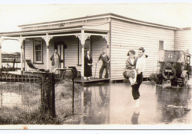 Lakes Entrance Historical Society
Photograph - Rosemont/Fraser, 1935 C
Sepia toned photograph of a man carrying a woman through flood water surrounding Rosemont House, Barkes Avenue. On the veranda of boarding house are Alice Fraser nee Falk, her daughter Joan and husband George leaning on stick, beside house is a soft topped sedan car with sign Telsons on back, Lakes Entrance Victoria.genealogy, guesthouses, floods -
University of Melbourne, Burnley Campus Archives
Map, Kororoit Creek Proposed ..... [words obscured], 1998
Composite photocopy so title partly obscured, by Thompson Berrill Landscape Design DWC No KC 13 Sheet 13 of 14 dated March 1998. Scale 1:200. Legend includes: Vegetation, Drainage and Flood Management Issues and Action, Water Quality, Stream System V? Issues, Primary Objectives (partially obscured).thompson berrill, landscape design, kororoit creek, water quality, vegetation -
University of Melbourne, Burnley Campus Archives
Newspaper - Newspaper Cutting, The South Bourke Standard, The Horticultural Society, 1864
Cop[y of article in "The South Bourke Standard" 29 July, 1864 p3. Description of the Annual Meeting of the Society. The December flood had destroyed the fruit tree plantings. The Government had refused a request to grant them more suitable land to the north so part of the ornamental section had to be broken up and planted with fruit trees.the south bourke standard, floods, ornamental garden broken up, fruit trees, fruit trees destroyed, refusal of government funding, government funding -
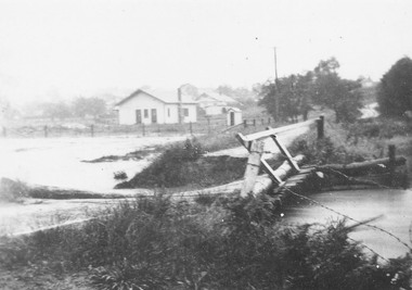 Ringwood and District Historical Society
Photograph, Mullum Creek in flood, Ringwood. Adelaide St. Bridge to Reynolds Ave washed away, 1931
Catalogue card reads, "Mullum Creek in flood. Adelaide St. Bridge to Reynolds Ave washed away, 1931". Typed below photograph, "Adelaide St. bridge, to Reynolds Ave washed out in 1931 (Bridge not replaced). 1934?" -
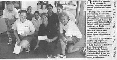 Ringwood and District Historical Society
Newspaper, Scrapbook Clipping, Library Collection, Ringwood, Victoria
Newspaper Clipping from "The Post", Tuesday May 19 1998. P 31 A group of students from Norwood Secondary College, during a visit to the Northern Territory organised a sponsored climb of Ayers Rock. They managed to raise $620 and donated it to their peers at Katherine High School, which was damaged during recent floods -
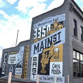 City of Ballarat
Artwork, other - Public Artwork, Travis Price, Main Road Mural by Travis Price, May 2018
Whilst my main focus for the artwork design was on the Hotels on Main Road, I felt there was an opportunity to tell a broader story of Main Rd and combine/include some interesting pieces of information from many stages of the history of Main Road. Considering that at one point in time there would have been at more than six hotels in this very short section of street….there’s no doubt Main Rd was an epicentre of communication and festivities for the Goldfields of Ballarat. “No matter what luck he had, every miner needed supplies, food and something to entertain him when he was not searching for gold.” Described as being an overcrowded jumble of muddy streets loosely arranged around mining camps...and loud, muddy, colourful and sometimes illicit. I wanted the artwork composition to consist of overlapping images and text to reflect this sense of hustle and bustle. Main Road Mural tells the broader story of the history of Main Road in Ballarat. In 2018, the City of Ballarat commissioned local Ballarat artist Travis Price to create an artwork to align with the Main Road Revitalisation Project and deliver a key component of the storytelling (heritage interpretation) project that spans the length of the shopping precinct. The artwork is featured on a prominent site in the shopping precinct of main road and tells the story of Main Road through depicting key timeline events. Main Road, as its name suggests, was one of the main entries to the mining areas of East Ballarat. It had several names: Main Street before 1858, Plank Road between 1858 and 1868 and Main Road from 1868 onwards. The centre of mining life, it was crowded, prosperous, raucous and dirty. Painted mural on shop wall in Main Road, BallaratBallaarat, Gold Fever, The Royal Standard Hotel, Flood, Boxing Saloon, Plank Road, Kulin Nation, 3350, Election, East, Grog House, The Scandinavian Hotel. Images; Chinese lantern, Pick & Shovel, Miners Licence burning.main road history, ballarat hotels, gold fever, wadawurrung, kulin nation