Showing 2033 items
matching accommodation
-
 Ballarat Tramway Museum
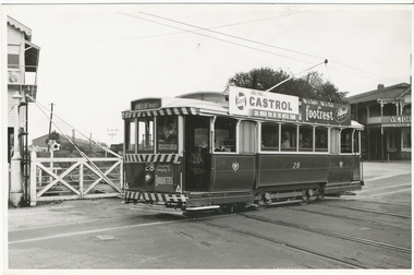
Photograph - Black & White Photograph/s, Lloyd Rogers, 21/03/1962 12:00:00 AM
Yields information about the appearance of SEC trams early 1960's at the Railway level crossing and the streetscape.Black and white photograph of Ballarat tram 28 crossing the level crossing. Dated 21/3/1962. Printed on Agfa Gevaert paper in a postcard format. Tram has the destination of Grey St Sebastopol, roof adverts for Castrol Oils and footrest shoes from Pittards of Ballarat and a front panel advert for SEC Briquettes. In the background are Ballarat "B" signal box and Victoria House accommodation facility. Photo by Lloyd Rogers.In ink "Car 28 on railway crossing - Lydiard St Ballarat 21/3/1962" and "7/42" and in pencil "ex M113".trams, tramways, level crossings, lydiard st, tram 28 -
 Linton and District Historical Society Inc
Floor plan, Floor plan of Railway Hotel, Linton, 1953
Architectural drawing showing block and floor plan of Linton's Railway Hotel. The plan appears to have been drawn up for the Ballarat Brewing Company, which owned the hotel, in connection with proposed renovations. Plan is initialled "J. O. O'B." and dated"5.5.53". Plan shows bar area, parlours and dining rooms, residential areas, ablutions areas, staff bedrooms, rooms used for accommodation, and outbuildings (stable, garage etc.).railway hotel linton, maps and plans, floor plans -
 Uniting Church Archives - Synod of Victoria
Document - MGC/MOK Interstate Rally - Melbourne, Rally Review No 5
This document, from the "Publicity Committee" is a "special barometer reading" of the Interstate Rally Melbourne Committee. There is no year on the document. Its aim is to encourage members of MGC and MOK to attend. Contacts numbers are given for catering, accommodation, worship and social.Blue foolscap paper with black printing one side.mgc mok interstate rally melbourne, mrs j williams, mr k hocking, jean martin, beryl senior -
 Uniting Church Archives - Synod of Victoria
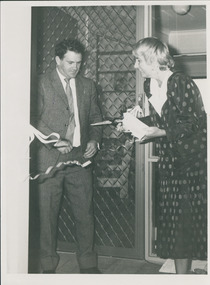
Photograph, Opening of Kilmany Orbost new units by politicians, 05/1986
Kilmany Family Care Community Residential Units - ordinary community houses that are adapted for accommodation for up to six people with intellectual disabilities - opened at Orbost. See article on p. 25 of C&N for May 14, 1986.Caroline Hogg, Community Affairs Minister & Barry Murphy MLC snipping ribbon at opening of new units.Identification of persons & place.kilmany family care, hogg, caroline, murphy, barry mlc -
 Expression Australia
Photographs - c. 1950s, Horace Bedggood Hostel
The Adult deaf and Dumb Society had long seen the need for a hostel to provide accommodation for Deaf Adults and the appeal launched in 1951 was brought to furuition in 1959 with the Horace Bedggood House (Men’s Hostel) opened at Jolimont Square.These photographs are significant as they show a major undertaking of the Adult Deaf and Dumb Society of Victoria - Horrace Bedggood House a Hostel for Deaf Adults.18cmHx24.5cmW and 15cmHx24.5cmWbedggood, hostel -
 Falls Creek Historical Society
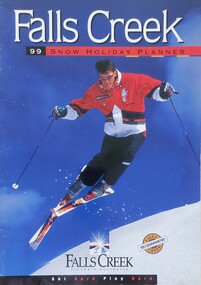
Magazine - Falls Creek 99 Snow Holiday Planner
Part of an annual marketing campaign, this booklet was designed to provide information for planning a holiday at Falls Creek for the winter of 1999. It includes details about activities, facilities and accommodation in the Village as well as contact information to make necessary bookings.This item is important as it documents seasonal activities at Falls Creek Alpine ResortA booklet containing detailed information and images including a map, prices and booking details.falls creek, winter sport, 1990s, falls creek marketing -
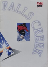 Falls Creek Historical Society
Magazine - Falls Creek 98 Holiday Planner
Part of an annual marketing campaign, this booklet was designed to provide information for planning a holiday at Falls Creek for the winter of 1998. It includes details about activities, facilities and accommodation in the Village as well as contact information to make necessary bookings.This item is important as it documents seasonal activities at Falls Creek Alpine ResortA booklet containing detailed information and images including a map, prices and booking details.falls creek, victoria, winter sport, falls creek marketing -
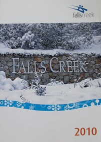 Falls Creek Historical Society
Booklet - Falls Creek Information 2010
Part of an annual marketing campaign, this booklet was designed to provide information for booking accommodation in Falls Creek in the winter of 2010. It was published by Falls Creek Central Reservations who were owned and operated by the Falls Creek Chamber of Commerce.This item is important as it documents seasonal activities at Falls Creek Alpine Resort An A4 sized marketing booklet, including images and advertising and booking information printed on glossy paper.falls creek marketing, falls creek accommodation, falls creek 2010, falls creek chamber of commerce -
 Falls Creek Historical Society
Booklet - Falls Creek 2002
Part of an annual marketing campaign, this booklet was designed to provide information for planning a holiday at Falls Creek for the winter of 2002. It includes details about activities, facilities and accommodation in the Village as well as contact information to make necessary bookings.This item is important as it documents seasonal activities at Falls Creek Alpine Resort An A4 sized marketing booklet, including images and advertising information printed on glossy paper.victoria, winter sport, falls creek marketing, falls creek 2002 -
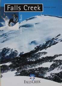 Falls Creek Historical Society
Booklet - Falls Creek Winter 2000 - Catch the Buzz
Part of an annual marketing campaign, this booklet was designed to provide information for planning a holiday at Falls Creek for the winter of 2000. It includes details about activities, facilities and accommodation in the Village as well as contact information to make necessary bookings.This item is important as it documents seasonal activities at Falls Creek Alpine Resort An A4 sized marketing booklet, including images and advertising information printed on glossy paper.falls creek, winter sport, falls creek marketing -
 Warrnambool and District Historical Society Inc.
Booklet - Warrnambool Visitor's Handbooks 1979-2024, Collett, Bain and Gaspar, Printers, 1979-2014
This is a collection of eight Warrnambool Visitor handbooks produced between 1979 and 2014 by the City of Warrnambool Tourist Information Centre. They contain maps of Warrnambool, lists of services, accommodation and tourist attractions as well as many advertisements for local businesses.These handbooks give a useful snapshot of businesses and tourist attractions in Warrnambool for each of the years covered. (1979, 1980, 1986, 1990, 1993, 1994, 1995, 2014)[.1a] A 48 page booklet with white pages and blue printing. The front cover has a coloured photograph of Flagstaff Hill with boats on a man made lake in the foreground looking across Lake Pertobe toward South Warrnambool. [.1b] A coloured bifold brochure. The front cover has a fisherman on a cray-boat holding a crayfish in the lower section. The top quarter has a blue back ground with white printing. The rear cover is red and has small photos of the Hopkins River and the Framlingham Forest. [.2] A 48 page booklet with white pages and black printing. The front cover is white with black writing on the left hand side and a colour photograph of the Loch Ard peacock. The Warrnambool Premier Town stylised logo of seven Norfollk pines above blue waves is in the top right hand corner. There is a blank ink Warrnambool Library stamp underneath the logo. The rear cover has photographs of The Twelve Apostles and the Hopkins Falls and the Premier Town Logo [.3] A 40 page booklet with mainly black printing on white paper. There are three fold out maps of Warrnambool and the surrounding district. The glossy cover has a black background with a colour photograph of the Twelve Apostles taken at sunset. The rear cover has three small of Proudfoot's boathouse on the Hopkins River, Flagstaff Hill, and the main beach area. The front cover has black writing inside to peach coloured rectangles. The inside rear cover has a fold out coloured tour map of Western Victoria. [.4] A 40 page booklet printed on glossy white paper with coloured photographs and black and red printing. The front cover has a photograph of The Twelve Apostles surrounded by a white border. There is red writing in the upper border. There is a sandy coloured writing superimposed across the bottom of the photograph and a Victoria's Shipwreck Coast logo in the bottom right hand corner. [.5] A 44 page booklet printed on white paper with black printing. The cream coloured cover has a pale red rectangle with blue writing on the right hand facing edge and includes two stylised Norfolk pines and with waves underneath. There is is an intersecting blue rectangle with cream printing. [.6] A 48 page booklet printed on white paper with black printing. The cover is brown with a cream vertical strip containing black writing on the right hand side. There is a stylised map from Geelong to Mount Gambier showing the Great Ocean Road across the cover. [.7] A 48 page booklet printed on white paper with black print. The glossy colour cover has a photograph of a Southern Right whale fluke. There is white printing on a the blue background of the sky and sea. The bottom left hand side of the front cover has a Tourism Victoria logo made of jigsaw puzzle pieces. The back cover has a stylised coloured map of The Great Ocean Road located in a white rectangle at the top of the page. Within the rectangle is a small map of Australia locating Victoria and the part of Victoria covered by the map. [.8] A 64 page A5 coloured booklet printed on white pages with black print. The white front cover has black and grey print with a colour photograph of two people holding coffee cups watching four race horses being exercised on the beach and in the water of Lady Bay in the early morning. The bottom right hand corner has a Tourism Victoria logo. The rear cover has a mainly blue back ground with a pink orange and green colour splats contains words advertising the 2015 Fun 4 Kids Festival [.1a] Warrnambool The Heart of Victoria's Great Southwest Visitor's Handbook [.1b] Warrnambool City for all seasons; The Heart of Victoria's Great Southwest [.2] Warrnambool visitor's handbook Warrnambool Premier Town 1979-1982 [.3] Warrnambool Handbook Victoria [.4] Warrnambool The Shipwreck Coast [.5] Welcome to Warrnambool Warrnambool Visitors Handbook 1993-1994 [.6] Welcome to Warrnambool Visitors Handbook 1994-95 Rear cover: Warrnambool Centre of Victoria's Shipwreck Coast on Australia's Great Ocean Road [.7] Warrnambool Shipwreck Coast - Great Ocean Road; You'll love every piece of Victoria; Visitors Handbook [.8] Warrnambool Great Ocean Road Official Visitor Guide; It's a wonderful Warrnambool; You'll love every piece of Victoria visitvictoria.com. Rear Cover Live entertainment.Workshops.Creativity.Action 28 June - 5 July 2015 Australia's Best Children's Festival F4K The ultimate winter school holiday adventure Fun 4 kids festival Warrnambool For more information visit Fun4kids.com.au Warrnambool great Ocean Road Victoriawarrnambool, visitor handbooks, tourist information guides, warrnambool maps -
 Kiewa Valley Historical Society
Photographs – Kiewa Cres Mt Beauty. Circa 1993. Set of 12 colour photographs
Established in 1946, during the construction of the Kiewa Hydro Electric Scheme, the township of Mt Beauty was developed by the State Electricity Commission of Victoria to provide additional accommodation for the thousands of workers during the construction of the country’s second largest hydro-electricity scheme. Although these towns were built as temporary accommodation for the workers and their families, many stayed after the scheme finished. Combined with the influx of European migrants, with their rich cultural backgrounds, all played a major part in shaping the future character of the Mount Beauty, the Kiewa Valley and Falls Creek. The Bright Council, now the Alpine Shire took over the control of the township in 1960. This relatively young town of Mount Beauty, along with the surrounding townships of Falls Creek, Bogong, Tawonga South and Tawonga, are all part of a prospering tourist area with excellent services, accommodation, food and a wide range of recreational activities available for all ages. According to Shire records, the population of Mt Beauty has grown from 1,500 in 1981 to 1,800 in 2016 with a projected increase to 2,000 in 2013The photographs taken around 1993 show a prosperous commercial centre catering for both locals and the needs of visitors. It provides a pictorial history of the changes which have occurred in the retail/commercial district of Mt Beauty over the years. It also demonstrates the attention paid by Alpine Shire towards providing accessible recreational green space around the town centre.Set of 12 colour photographs of Kiewa Cres Mt Beauty. Circa 1993 showing retail services and streetscape of the time. No markingskiewa cres mt beauty, mt beauty -
 Kiewa Valley Historical Society
Photographs – Lakeside Avenue, Mt Beauty. Circa 1993. Set of 7 colour photographs
Established in 1946, during the construction of the Kiewa Hydro Electric Scheme, the township of Mt Beauty was developed by the State Electricity Commission of Victoria to provide additional accommodation for the thousands of workers during the construction of the country’s second largest hydro-electricity scheme. Although these towns were built as temporary accommodation for the workers and their families, many stayed after the scheme finished. Combined with the influx of European migrants, with their rich cultural backgrounds, all played a major part in shaping the future character of the Mount Beauty, the Kiewa Valley and Falls Creek. The Bright Council, now the Alpine Shire took over the control of the township in 1960. This relatively young town of Mount Beauty, along with the surrounding townships of Falls Creek, Bogong, Tawonga South and Tawonga, are all part of a prospering tourist area with excellent services, accommodation, food and a wide range of recreational activities available for all ages. According to Shire records, the population of Mt Beauty has grown from 1,500 in 1981 to 1,800 in 2016 with a projected increase to 2,000 in 2013The photographs taken around 1993 show a prosperous commercial centre catering for both locals and the needs of visitors. It provides a pictorial history of the changes which have occurred in the retail/commercial district of Mt Beauty over the years. It also demonstrates the attention paid by Alpine Shire towards providing accessible recreational green space around the town centre.Set of 7 colour photographs of Lakeside Avenue, Mt Beauty. Circa 1993 showing retail services and streetscape of the time. No markingsmt beauty, lakeside ave mt beauty -
 Kiewa Valley Historical Society
Photographs – Tawonga Cres., Mt Beauty. Circa 1993. Set of 4 colour photographs
Established in 1946, during the construction of the Kiewa Hydro Electric Scheme, the township of Mt Beauty was developed by the State Electricity Commission of Victoria to provide additional accommodation for the thousands of workers during the construction of the country’s second largest hydro-electricity scheme. Although these towns were built as temporary accommodation for the workers and their families, many stayed after the scheme finished. Combined with the influx of European migrants, with their rich cultural backgrounds, all played a major part in shaping the future character of the Mount Beauty, the Kiewa Valley and Falls Creek. The Bright Council, now the Alpine Shire took over the control of the township in 1960. This relatively young town of Mount Beauty, along with the surrounding townships of Falls Creek, Bogong, Tawonga South and Tawonga, are all part of a prospering tourist area with excellent services, accommodation, food and a wide range of recreational activities available for all ages. According to Shire records, the population of Mt Beauty has grown from 1,500 in 1981 to 1,800 in 2016 with a projected increase to 2,000 in 2013The photographs taken around 1993 show a prosperous commercial centre catering for both locals and the needs of visitors. It provides a pictorial history of the changes which have occurred in the retail/commercial district of Mt Beauty over the years. It also demonstrates the attention paid by Alpine Shire towards providing accessible recreational green space around the town centre.Set of 4 colour photographs Tawonga Crescent, Mt Beauty. Circa 1993 showing retail services and streetscape of the time No markingstawonga cres mt beauty -
 Kiewa Valley Historical Society
Photographs – Holland Street North, Mt Beauty. Circa 1993. Set of 18 colour photographs
Established in 1946, during the construction of the Kiewa Hydro Electric Scheme, the township of Mt Beauty was developed by the State Electricity Commission of Victoria to provide additional accommodation for the thousands of workers during the construction of the country’s second largest hydro-electricity scheme. Although these towns were built as temporary accommodation for the workers and their families, many stayed after the scheme finished. Combined with the influx of European migrants, with their rich cultural backgrounds, all played a major part in shaping the future character of the Mount Beauty, the Kiewa Valley and Falls Creek. The Bright Council, now the Alpine Shire took over the control of the township in 1960. This relatively young town of Mount Beauty, along with the surrounding townships of Falls Creek, Bogong, Tawonga South and Tawonga, are all part of a prospering tourist area with excellent services, accommodation, food and a wide range of recreational activities available for all ages. According to Shire records, the population of Mt Beauty has grown from 1,500 in 1981 to 1,800 in 2016 with a projected increase to 2,000 in 2013The photographs taken around 1993 show a prosperous commercial centre catering for both locals and the needs of visitors. It provides a pictorial history of the changes which have occurred in the retail/commercial district of Mt Beauty over the years. It also demonstrates the attention paid by Alpine Shire towards providing accessible recreational green space around the town centre.Set of 18 colour photographs Holland Street North, Mt Beauty. Circa 1993 showing retail services and streetscape of the time. No markingsholland st mt beauty, mt beauty -
 Kiewa Valley Historical Society
Photographs – Holland Street South, Mt Beauty. Circa 1993. Set of 16 colour photographs
Established in 1946, during the construction of the Kiewa Hydro Electric Scheme, the township of Mt Beauty was developed by the State Electricity Commission of Victoria to provide additional accommodation for the thousands of workers during the construction of the country’s second largest hydro-electricity scheme. Although these towns were built as temporary accommodation for the workers and their families, many stayed after the scheme finished. Combined with the influx of European migrants, with their rich cultural backgrounds, all played a major part in shaping the future character of the Mount Beauty, the Kiewa Valley and Falls Creek. The Bright Council, now the Alpine Shire took over the control of the township in 1960. This relatively young town of Mount Beauty, along with the surrounding townships of Falls Creek, Bogong, Tawonga South and Tawonga, are all part of a prospering tourist area with excellent services, accommodation, food and a wide range of recreational activities available for all ages. According to Shire records, the population of Mt Beauty has grown from 1,500 in 1981 to 1,800 in 2016 with a projected increase to 2,000 in 2013The photographs taken around 1993 show a prosperous commercial centre catering for both locals and the needs of visitors. It provides a pictorial history of the changes which have occurred in the retail/commercial district of Mt Beauty over the years. It also demonstrates the attention paid by Alpine Shire towards providing accessible recreational green space around the town centre.Set of 16 colour photographs Holland Street South, Mt Beauty. Circa 1993 showing retail services and streetscape of the time. No markingsholland st mt beauty, mt beauty -
 Kiewa Valley Historical Society
Photographs – Kiewa Cres Mt Beauty. Circa 1993. Set of 12 colour photographs, circa 1993
Established in 1946, during the construction of the Kiewa Hydro Electric Scheme, the township of Mt Beauty was developed by the State Electricity Commission of Victoria to provide additional accommodation for the thousands of workers during the construction of the country’s second largest hydro-electricity scheme. Although these towns were built as temporary accommodation for the workers and their families, many stayed after the scheme finished. Combined with the influx of European migrants, with their rich cultural backgrounds, all played a major part in shaping the future character of the Mount Beauty, the Kiewa Valley and Falls Creek. The Bright Council, now the Alpine Shire took over the control of the township in 1960. This relatively young town of Mount Beauty, along with the surrounding townships of Falls Creek, Bogong, Tawonga South and Tawonga, are all part of a prospering tourist area with excellent services, accommodation, food and a wide range of recreational activities available for all ages. According to Shire records, the population of Mt Beauty has grown from 1,500 in 1981 to 1,800 in 2016 with a projected increase to 2,000 in 2013The photographs taken around 1993 show a prosperous commercial centre catering for both locals and the needs of visitors. It provides a pictorial history of the changes which have occurred in the retail/commercial district of Mt Beauty over the years. It also demonstrates the attention paid by Alpine Shire towards providing accessible recreational green space around the town centre.Set of 12 colour photographs Kiewa Cres Mt Beauty. Circa 1993 showing retail services and streetscape of the time. No markingskiewa crescent mt beauty; shopping centre; -
Old Colonists' Association of Ballarat Inc.
Document, Clare Gervasoni, Williams Cottage Property Report - 3 Charles Anderson 2021, 2021
The Old Colonists' Association Ballarat Inc. (OCA) is a not-for-profit charitable organisation providing accommodation for those older Australians who are in financial need and risk, with no ingoing payment required and at a low rental. It manages a 42 Home retirement village at Charles Anderson Grove Ballarat. The village comprises single and double independent living units. Accommodation is offered at significantly below market rates. It has been providing low-cost accommodation to the elderly since the 1920s. The Association Council overseas the running of this facility on a voluntary basis. One of the first objectives of the Association was "to provide the shelter of a house for those Pioneers of the Goldfields whom the reverses of fortune have deprived of the means of procuring the comforts of life in their declining years." The first home at Charles Anderson Grove was built in 1925. Before that time the Association provided relief for needy pioneers. Relief included monthly monetary payments, loads of firewood, medical assistance and distribution of Christmas boxes of groceries to deserving pensioners, and in some cases payment of burial costs. A written report into the history of the Williams Cottage at 3 Charles Anderson 20213 charles anderson grove, charles anderson grove, williams cottage, property report, fred williams, matilda williams, philanthropy -
![Township of Lorne, and Loutitt Bay / [by] Nicholas Caire, circa 1876](/media/collectors/550653872162f11fb04854aa/items/5783458ad0cdd1176c6f0c78/item-media/578345eed0cdd1176c6f852b/item-fit-380x285.jpg) Kew Historical Society Inc
Kew Historical Society IncPhotograph, Anglo-Australasian Photographic Company, Township of Lorne, and Loutitt Bay, c. 1876
Nicholas Caire was born on Guernsey in the Channel Islands in 1837. He arrived in Adelaide with his parents in about 1860. In 1867, following photographic journeys in Gippsland, he opened a studio in Adelaide. From 1870 to 1876 he lived and worked in Talbot in Central Victoria. In 1876 he purchased T. F. Chuck's studios in the Royal Arcade Melbourne. In 1885, following the introduction of dry plate photography, he began a series of landscape series, which were commercially successful. As a photographer, he travelled extensively through Victoria, photographing places few of his contemporaries had previously seen. He died in 1918. Reference: Jack Cato, 'Caire, Nicholas John (1837–1918)', Australian Dictionary of Biography.An original, rare photograph from the series 'Views of Victoria: General Series' by the photographer, Nicholas Caire (1837-1918). The 60 photographs that comprise the series were issued c. 1876 and reinforced a neo-Romantic view of the Australian landscape to which a growing nationalist movement would respond. Nicholas Caire was active as a photographer in Australia from 1858 until his death in 1918. His vision of the Australian bush and pioneer life had a counterpart in the works of Henry Lawson and other nationalist poets, authors and painters.‘Township of Lorne, and Loutitt Bay’ : Views of Victoria (General Series) No.60 : Albumen silver photograph | Photo on card with Title and Description on reverse | Mounted 24 x 30 cm; Photo 12 x 17 cm.On Reverse: ‘Loutitt Bay is fast becoming one of the most fashionable Watering-places in Victoria, partly from its easy access by Rail, combined with the magnificent scenery to be found in the Cape Otway Ranges, and the very moderate charges of the houses of accommodation. The large house near the foreground is that of Mr. Mountjoy, which is a Restaurant. Duncan’s Hotel can be seen in the distance, on the brow of the hill.’nicholas caire (1837-1918), lorne (vic), duncan's hotel, loutitt bay, landscape photography - victoria -
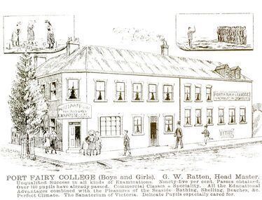 Port Fairy Historical Society Museum and Archives
Photograph - Lithograph
This card was probably used as an advertisement. (The Stag built 1848-1853.Land was purchased from Atkinson to build a licensed premises, it later became a boarding house also a boarding school now is used mainly as accommodation and also a Restaurant )Black and white photograph of a drawing of Seacombe House as Port Fairy College with large descriptionPort Fairy College (Boys and Girls) G.W.Ratten Headmaster. I qualified success in all kinds of examinations. Ninety five per cent passes obtained. Over 100 pupils already passed. Commercial classes a speciality. All the educational advantages combined with the pleasures of the seaside, bathing, shelling, beaches & c. Perfect climate. The Sanatorium of Victoria. Delicate pupils especially cared forhotel, stag, seacombe, inn, boarding school, sackville street, cox street -
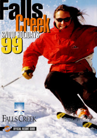 Falls Creek Historical Society
Magazine - Falls Creek '99
Part of an annual marketing campaign, this booklet was designed to provide information for planning a holiday at Falls Creek for the winter of 1999. It includes extensive details about activities, facilities and accommodation in the Village as well as contact information to make necessary bookings.This item is important as it documents seasonal activities at Falls Creek Alpine ResortMagazine titled Falls Creek '99 containing information and images for 1999 winter holidays. Front cover with close image of woman skiing downhill with magazine title down left side of page. Falls / Creek / SNOW HOLIDAYS / 99 / FALLS CREEK / VICTORIA AUSTRALIA / OFFICIAL RESORT GUIDEfalls creek marketing, falls creek accommodation, facilities falls creek -
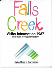 Falls Creek Historical Society
Booklet - Brochure - Falls Creek Visitor Information 1987
Part of an annual marketing campaign, this booklet was designed to provide information for planning a holiday at Falls Creek for the winter of 1987. It includes extensive details about activities, facilities and accommodation in the Village as well as contact information to make necessary bookings.This item is important because it documents seasonal activities at Falls Creek Alpine ResortFold out information guide for Falls Creek winter holidays 1987 including images, text and maps,falls creek marketing, falls creek winter programs, falls creek village -
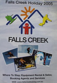 Falls Creek Historical Society
Booklet - Falls Creek Holiday 2005
Part of an annual marketing campaign, this booklet was designed to provide information for planning a holiday at Falls Creek for the winter of 2005. It includes details about activities, facilities and accommodation in the Village as well as maps and contact information to make necessary bookings.This item is important as it documents seasonal activities at Falls Creek Alpine Resort An A4 sized marketing booklet, including images and advertising information printed in colour and black and white.falls creek marketing, falls creek 2005, falls creek accommodation -
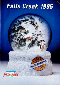 Falls Creek Historical Society
Magazine - Falls Creek 1995
Part of an annual marketing campaign, this booklet was designed to provide information for planning a holiday at Falls Creek for the winter of 1995. It includes extensive details about activities, facilities and accommodation in the Village as well as contact information to make necessary bookings.This item is important as it documents seasonal activities at Falls Creek Alpine ResortMagazine titled Falls Creek '95 containing information and images for 1995 winter holidays. Front cover with image of snow globe with people skiing in it. Falls Creek logo on bottom left corner. Advertising on back page. Falls Creek 1995 / FALLS / SKI GUARANTEE / CREEK / FALLS CREEK / VICTORIAskiing, ski, falls creek, victoria, school holidays, winter, snow, winter sport, 1990s, marketing, graphic design -
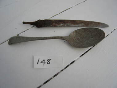 Parks Victoria - Wilsons Promontory Lightstation
Spoon and knife
Used by RAAF personell in accommodation quarters 1942 -1946. WWII wartime objects – living in the RAAF camp . They provide evidence of the contents of the RAAF barracks and recreation hut erected in 1942 and occupied until 1945. Some of the items such as cutlery, a wood heater/stove, domestic radio (remnants) were used in daily life by servicemen. Spoons x 3 (WPLS 0101.3; likely provenance); spoon and knife (0148.2 likely provenance)The two metal small spoons, two large spoons and knife without its handle are known to have been used by WWII RAAF or navy personnel in their accommodation quarters 1942-1945. The items, if original to the site, have second level contributory significance for the evidence they provide of the WWII buildings and their use between 1942 and 1945. Metal spoon and a serrated edged knife without a handle. Both items have some corrosion. -
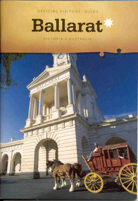 Ballarat Tramway Museum
Book, The Ballarat Visitor Information Centre, "Official Visitors Guide, Ballarat, Victoria, Australia", Jul. 2006
Full colour, 84 page, book, A5 size titled "Official Visitors Guide, Ballarat, Victoria, Australia", with a Cobb and Co Coach standing in front of the Ballarat Railway station portico on the front cover. Gives details, maps accommodation listing, attractions etc of the Ballarat area. Pages 18 and 19 detail the Ballarat Tramway Museum and page 22 has the BTM advertisement. Published July 2006 by The Ballarat Visitor Information Centre.trams, tramways, ballarat, visitors, tourist guides, btm -
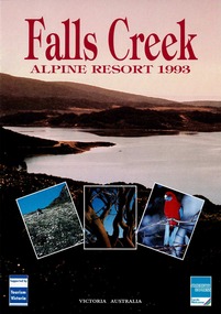 Falls Creek Historical Society
Magazine - Falls Creek Alpine Resort 1993
A part of a yearly marketing magazine promoting Falls Creek region in the summer. This item is important as it documents seasonal activities at Falls Creek Alpine ResortMagazine titled Falls Creek Alpine Resort 1993. Front cover is an image of lake area with Fall Creek Alpine Resort titled centre top in red and three nature photos framed centre bottom. American Express logo bottom right and blue back cover with Falls Creek Chamber of Commerce and American Express at bottom of page. Six internal pages with outdoor images and accommodation information for Summer in Falls Creek. falls creek, victoria, school holidays, 1990s, marketing, graphic design, summer, accomodation, vacation, alpine, alpine resort -
Canterbury History Group
Photograph - Canterbury Mansions, Jan Pigot, 1993
Coloured photograph of Canterbury Mansions on the western corner of Wattle Valley Road and Canterbury Road, Canterbury. Built in 1889 for William Malone whose family owned it until the 1920s (known as Malone's Hotel and later Canterbury Club Hotel). Several other licensees until the local option poll of 1920 resulted in its closure as a licensed hotel. Continued as a guest house or private accommodation until its sale and redevelopment in the 1990s as professional suites.canterbury, canterbury mansions, malones hotel, canterbury club hotel, hotels, canterbury post office, wattle valley road, canterbury road, maling road, telegraph and light poles -
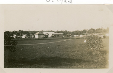
 Lakes Entrance Historical Society
Photograph - Camping Park, Jemmeson Edie, 1928
This fully self contained camp park containing accommodation, general store, entertainment, Rotunda, petrol bowsers and community kitchen was the vision of Richard Bromby Whiter who commenced the project in 1927. Water for gardening and sewerage supplied by an underground boreSmall format black and white photograph of the entrance to the planned Lakes Camping Park fronting Roadknight Street. Shows homestead, cabin and tents, small tree in foreground, vehicle at side. Vera Wilson, later Vera Harbeck, standing outside entrance. Lakes Entrance Victoriatourism, recreation, camping, room display -
 Lakes Entrance Historical Society
Photograph, Jemmeson, Edie, 1928
The fully self contained camp park containing accommodation, general store, entertainment rotunda, petrol bowsers and community kitchen was the vision of Richard Bromby Whiter who commenced the project in 1927. Water for gardening and sewerage supplied by an underground bore.Black and white photograph of the entrance to the planned Lakes Camping Park, fronting Roadknight Street, Lakes Entrance, Victoria.tourism, recreation, caravan parks