Showing 3982 items
matching demolished houses
-
 Mission to Seafarers Victoria
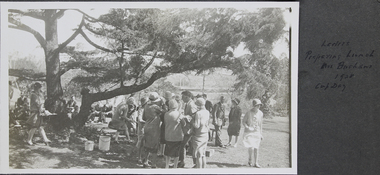
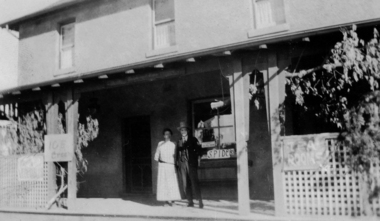
Photograph - Photograph, Black and White, Ladies preparing lunch Mrs Buchans 1928 Cup Day, November 1928
... 1922, but his wife continued with the tradition. The house... 1922, but his wife continued with the tradition. The house ...Mr John Innerarity Buchan, Scottish real estate, and his wife. organised at least 4 known outings at their property - Finhaven - in Studley Park, Kew. Those parties were hosted for Cup Day in 1920, 1922, 1924 and 1928. Mr Buchan died in December 1922, but his wife continued with the tradition. The house was sold and demolished in 1941 to create several allotments around Finhaven Court.on oage 13finhaven, mr john inerrarity buchan, cup day, studley park, kew, reverend john reginald weller (1880-1969), 1928, fan album -
 Lorne Historical Society
Print - Framed coloured print, Print Accommodation Lorne to 1950
... . Many of the guest houses have since been demolished. Rob Coy ...Rob Coy depicted the 22 following buildings with a map 1. Bonnie Doon 2. Gracedale 3. Cora Lynn 4. Carinya 5. Kia-Ora 6. Kalimna 7. Argyll 8. Minapre 9. Erskine House 10.Hotel Pacific 11. The Cumberland 12. Riverview 13. Hotel Lorne 14. The Chalet 15. Santoy 16. Clovelly 17. Yendallock 18. Nenthorne 19. Quamby 20. Ben-My-Kree 21. Glenora 22. Ozone House Rectangular framed color print of Rob Coy ‘ sketch Accommodation Lorne to 1950. The guest houses were, Bonnie Doon, Gracedale, Cora Lyn, Karinya, Kia Ora, Kalimna, Argyle, Minapre, Erskine House, Hotel Pacific, Cumberland, Riverview, Lorne Hotel, Chalet, Santoy, Clovelly, Yendaloch, Nenthorne, Quamby, Ben - My Cree, Glendora, Ozone House and a small map showing the locations of the accommodation. We believe this this is the original print. The colors are mainly blue and light tan. rob coy, lorne, accommodation, hotels, guest houses, pubs, erskine house -
 Mission to Seafarers Victoria
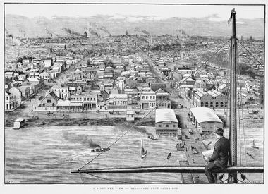
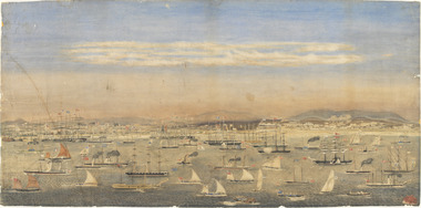
Print - Wood engraving, F.A. Sleap, A Bird's-eye View Of Melbourne From Sandridge, 2 September 1885
The illustration published in the Illustrated Australian News (Melbourne, Vic. : 1876 - 1889), p. 144, on 2 September 1885, depicts Sandridge now Port Melbourne in 1885 from a seamen's point of view on board a ship.This engraving is a rare depiction fo the Bethel church as there is no early photograph. The Sailors' Rest is located at the back. In 1887, the church was demolished to erect the building still standing on the corner of Nott Street and Beach Road.Copy of an engraving depicting a sailor sitting on the mast of the ship and looking at the shore from the sea. A Bird's-eye View Of Melbourne From Sandridge.nott street, sandridge, melbourne, port melbourne, beach road, seamen, ships, sails, sailing ships, customs house, bethel church -
 Phillip Island and District Historical Society Inc.
Photograph, Innishowen, 1978/9
Innishowen - home of William Harbison from 1868. Bought by Gliddon Family in 1911 and demolished in 1976 by owner G Gliddon. Present photograph of painting taken 1978/1979Innishowen - the home of William Harbison who owned most of the south western section of Phillip Island from 1868. Coloured photograph of painting of Innishowen showing house and garden. Green roofing iron.local history, photographs, buildings - historical, coloured photograph, john cook, innishowen, ventnor, phillip island, harbison -
 Phillip Island and District Historical Society Inc.
Photograph, 1976
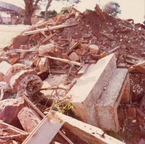
As "Innishowen" was demolished in 1976 this photograph must have been taken around this time. The owner was G Gliddon whose family bought it in 1911.Coloured photograph of rubble from demolition of "Innishowen" house in 1976. Wood and concrete visible.local history, photographs, buildings - historical, coloured photograph, john cook, innishowen, ventnor, phillip island -
 Mortlake and District Historical Society
Photograph - The old vicarage, F.B.W. Stevenson, Photographer (on back)
Shows a bluestone house surrounded by lush, well-developed garden. House is in good order with 4 chimneys, a porch and water-tank. To the left, partially obscured by the shrubbery stands the bearded Rev.Wagg with hat. To the right is a girl around ?10 years old, with parasol and hat in her hands. This was Mortlakes' Anglican Vicarage from c. 1886 to c.1916 when present one was built next to St.James church in Shaw Street. House stood in Sagnol's paddock (Waggs Lane) until 1950's when it was demolished reportedly by a group of boys using dynamite!) Rev. Wagg was a long-serving and well-regarded Anglican minister who served Mortlake from 1886 to1916. Wagg's Lane takes its name from his former residency there. A new Vicarage was built c.1916 next to the church. The old vicarage was reduced to rubble reputedly by boys using gelignite in the 1950's; the remains can be seen in the paddock on Wagg's Lane.Sepia rectangular photograph on cardboard backingWritten on the back: The Vicarage Mortlakechurch, anglican, mortlake, wagg, lane, waggs -
 Mission to Seafarers Victoria
Print - Reproduction, Wilbraham Frederick Evelyn Liardet, View of the North Shore, Port of Melbourne, 1862
Liardet, W. F. E. (Wilbraham Frederick Evelyn), 1799-1878 depicts the busy port of Melbourne showing many types of ships and the Bethel Church built in 1860 on the Custom House land. The church replaced the Bethel ship which sank in February 1860.This watercolour along with the Francois Cogne print from 1863, "Sandridge from Hobson's Bay, and the engraving "A Bird's-eye View Of Melbourne From Sandridge" dating from 1882, is a rare depiction fo the Bethel church. In 1887, the church was demolished to erect the building still standing on the corner of Nott Street and Beach Road.wilbraham liardet, sandridge, port, ships, port melbourne, hobsons bay, bethel church, reverend kerr johnston, 1812-1887, missions to seamen, 1862, customs house -
 Glenelg Shire Council Cultural Collection
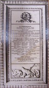
Photograph - Photograph - Memorial to those who risked their lives, n.d
Memorial to those who risked their lives at the wreck of 'Admella', Cape Northumberland 1859 (label, lwr left). Memorial was installed at the Sailors Home, Siddeley Street, Melbourne (now demolished) (label, lwr right)Front: (no inscriptions) -
Glenelg Shire Council Cultural Collection
Postcard - Postcard - Sandford House, n.d
Postcard, illustration of Sandford House. John Henty took up the licence in 1842. It was demolished in 1949. cream card.henty, sandford, sandford house -
Glenelg Shire Council Cultural Collection
Photograph - Photograph - View of Portland and foreshore, 21/03/1972
Port of Portland Authority archives.Front: (no inscriptions) Back: (no inscriptions)port of portland archives -
 Greensborough Historical Society
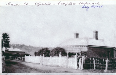
Photograph - Digital image, Roy house 1, 1930c
Photograph of the Roy house in Main Street Greensborough. This house was situated opposite the present entrance to Greensborough Plaza, but has been demolished. An early view of the residential area which is now a commercial strip.Digital copy of black and white photograph.Written on front of photograph: "Main St. opposite complex entrance - Roy house"roy family -
 Greensborough Historical Society
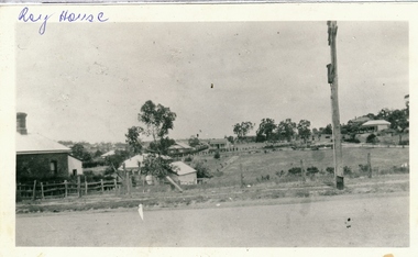
Photograph - Digital image, Roy house 2, 1930c
Photograph of the Roy house in Main Street Greensborough. This house was situated opposite the present entrance to Greensborough Plaza, but has been demolished. An early view of the residential area which is now a commercial strip.Digital copy of black and white photograph.Written on front of photograph: "Roy house"roy family, main street greensborough -
![Postcard - Digital image, Main Road Greensborough [showing Methodist Church], 1902](/media/collectors/4f729f5697f83e03086015b8/items/54e05e832162f11b9403aebc/item-media/54e05ead2162f11b9403b247/item-fit-380x285.jpg) Greensborough Historical Society
Greensborough Historical SocietyPostcard - Digital image, Main Road Greensborough [showing Methodist Church], 1902
This postcard of Main 'Road' Greensborough looking north shows the Methodist Church to the left and small houses on the dirt road. Today Main Street Greensborough is a busy commercial area. The postcard was addressed to Miss A Medhurst. Amy Medhurst married Jim Knapsey.The Methodist Church was sited near the present entrance to Greensborough Plaza and was demolished during the Plaza's development.Digital copy of sepia postcard [damaged]Caption on back of card.methodist church greensborough, main street greensborough, medhurst family -
 Greensborough Historical Society
Photograph - Digital image, Marble Hall, 1930-1940
Photograph of "Marble Hall", Greensborough. The Marble Hotel, Greensborough was located at the corner of Main Street and Para Road. The first licensed hotel in Greensborough and one of the earliest brick buildings was built by James Chapman in the early 1850s as a hotel and lodging house to cater for wood carters and those trying their luck at the gold fields but served many functions over the years including post office, general store, public hall, butchers, bakers, surgery, private dwelling and baby health care centre. It got its name due to its white washed exterior. This photo is from the Lorraine Coates Collection.Photograph of early Greensborough building, now demolished.Digital copy of black and white photograph.marble hotel greensborough, james chapman, marble hall greensborough -
 Greensborough Historical Society
Photograph - Digital image, Jessie Partington's house, Carnon Street, 1940c
This house in Carnon Street Greensborough was the home of Jessie Partington. It was demolished around 2005 for a block of units.Digital copy of black and white photograph.jessie may partington, jessie angus, jessie scholes, carnon street -
 Greensborough Historical Society
Photograph - Digital image, Marilyn Smith, Old Ely House in Greensborough 2010, 03/07/2010
Recent photograph of one of the older houses in Greensborough. This house is in Grimshaw Street Photo taken at the very beginning of the construction of the Watermarc precinct. This house at 49 Grimshaw Street, along with the one next door at 47 Grimshaw Street were built by John Ely, son of Frederick Ely. John and his wife Melinda(Iredale), lived in Main Street (where is father Fred lived), then Grimshaw Street, John a labourer, later an assistant. John owned land in Grimshaw Street, where he built their home, he subdivided the land, this was when Eldale Avenue came to be, a combination of John’s and Melinda’s surnames. He sold a block of land, to Dr. E.R. Cordner, this is where the Cordner house, “Ashmead” was built. John and Melinda’s house later (mid 1970's) became a 'Ely House Medical Centre' owned by Drs. Myerscough and Hugh T McDonald . Alan (John's son) and Maisie’s a Physiotherapy Centre. Later Drs Stephen Hanslow and Dr. Eastern operated the medical centre. The house at 47 Grimshaw Street was demolished in 2017.Digital copy of colour photograph.grimshaw street greensborough -
 Greensborough Historical Society
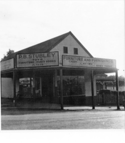
Photograph - Digital image, Stubley's Furniture, 1958c
Stubley's Furniture Store late 1950s. The Stubley Group began in 1946 when Purcell Stubley purchased a site with petrol bowsers in Main Street from 'Snowy' Jessop. In 1948 Purcell began building the new Stubley Motors, working round the old site to keep the business operating. It was completed in 1951. The Group expanded into other areas such as this Furniture store. [Syd Thompson Fruit Shop was here in early 1950s, Syd lived in the house at back. He coached Boxing]. This became the Welkay Store in the 1960's and owned by Walter Kenyon. The Welkay store moved opposite to 100 Main Road on 6/9/1966, ref: Diamond Valley News Page 9. Soon after the store would have been demolished to make way for 'The Valley Building' still on the site in 2018.Digital copy of black and white photographpurcell stubley, stubley motors, stubley group greensborough -
Glenelg Shire Council Cultural Collection
Administrative record - Police Report - sheep stealing, 1915, 07/09/1914
Barry was a police officer stationed at Portland 1969 - 71. Stables were to be demolished. he was instructed to clean them out, and take the contents to the tip. He retained these documents and donated them to the Cultural Collection.Hand written supplementary Police Report of Criminal Offence. Details sheep stealing, Heywood police station, 14 August 1915.police report, sheep stealing, livestock theft -
Glenelg Shire Council Cultural Collection
Administrative record - Police Report - theft of hurricane lamp, 1914, 03/10/1914
Barry was a police officer stationed at Portland 1969 - 71. Stables were to be demolished. he was instructed to clean them out, and take the contents to the tip. He retained these documents and donated them to the Cultural Collection.Hand written supplementary Police Report of Criminal Offence - larceny, one hurricane lamp, Yeitz pattern, glass lined, in good condition, Hamilton police stationBack: 'Warrnambool 6/10/14 RH Portand' hand written , black penpolice report, theft, hamilton police station -
Glenelg Shire Council Cultural Collection
Administrative record - Police Report - theft of a bicycle in Casterton, 1913, 12/04/1913
Barry was a police officer stationed at Portland 1969 - 71. Stables were to be demolished. he was instructed to clean them out, and take the contents to the tip. He retained these documents and donated them to the Cultural Collection.Hand written , supplementary Police Criminal Offence report - larceny of a bicycle, Casterton Police station, 12 April 1913police report, crime, 1913 -
Glenelg Shire Council Cultural Collection
Administrative record - Police Report - sheep theft, Hamilton, 1912, 07/06/1912
Barry was a police officer stationed at Portland 1969 - 71. Stables were to be demolished. he was instructed to clean them out, and take the contents to the tip. He retained these documents and donated them to the Cultural Collection.Typed copy of crime report from Police Superintendent's office, Hamilton - sheep stealingpolice report, sheep theft, livestock theft, hamilton -
Glenelg Shire Council Cultural Collection
Administrative record - Police Report - Casterton Police Station, 1912, 16/11/1912
Barry was a police officer stationed at Portland 1969 - 71. Stables were to be demolished. he was instructed to clean them out, and take the contents to the tip. He retained these documents and donated them to the Cultural Collection.Hand written supplementary Police Report of Criminal Offence - larceny, six coils of wire, Casterton police stationBack: Continuation of 'Steps taken, where information sent etc from front pagepolice report, theft, casterton -
Glenelg Shire Council Cultural Collection
Administrative record - Police Report - failure to pay child support, 1914, 24/04/1914
Barry was a police officer stationed at Portland 1969 - 71. Stables were to be demolished. he was instructed to clean them out, and take the contents to the tip. He retained these documents and donated them to the Cultural Collection.Hand written supplementary Police Report of Criminal Offence - disobeying court order, to pay 2/6 weekly for the support of a child, a ward of the state, Collingwood police station.police report, child support, 1914 -
Glenelg Shire Council Cultural Collection
Administrative record - Police Report - Warrnambool Police Station, 1913, 24/09/1913
Barry was a police officer stationed at Portland 1969 - 71. Stables were to be demolished. he was instructed to clean them out, and take the contents to the tip. He retained these documents and donated them to the Cultural Collection.Hand written supplementary Police Report of Criminal Offence - larceny (theft) of a horse saddle and bridle, Warrnambool police station, 24 September, 1913.police report, warrnambool police, theft, crime, 1913 -
Glenelg Shire Council Cultural Collection
Administrative record - Police Report - damage to property, 1914, 29/04/1914
Barry was a police officer stationed at Portland 1969 - 71. Stables were to be demolished. he was instructed to clean them out, and take the contents to the tip. He retained these documents and donated them to the Cultural Collection.Hand written supplementary Police Report of Criminal Offence - wilful damage to property, Dartmoor police station (shot gun pellets to school roof)police report, criminal damage, 1914, dartmoor -
Glenelg Shire Council Cultural Collection
Administrative record - Police Report - theft, 1914, 13/04/1914
Barry was a police officer stationed at Portland 1969 - 71. Stables were to be demolished. he was instructed to clean them out, and take the contents to the tip. He retained these documents and donated them to the Cultural Collection.Hand written supplementary Police Report of Criminal Offence - larceny, Dartmoor police stationpolice report, theft, crime, 1914 -
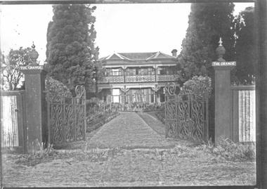 City of Moorabbin Historical Society (Operating the Box Cottage Museum)
Photograph - 3 black & white Photographs, 'The Grange' ( 'Baydon Hill' ) Moorabbin, c 1920
'The Grange ' was a 2 storey home built 1857 by Mr Charles Tuck, originally named 'Baydon Hill' , at 1011 Nepean Highway, Moorabbin ( South Brighton). Mr Charles Tuck was Veterinary Surgeon from Baydon Hill, Wiltshire, England, who migrated to Australia c1850. He married his cousin Miss Jan Chaudler in Melbourne in1853. He was at the Ballarat gold-fields at the time of the riots and then they settled in South Brighton ( later Moorabbin) and built a large Georgian Styled home called 'Baydon Hill'. The Tucks had a large family - 9 children. Charles enjoyed a prosperous Veterinary Practice as his advice was needed for stock purchases by the farmers / settlers. Charles died in 1893 and Jane left the property c 1903 and died at Blackburn in 1928. The House had 5 owners, the last being the Healey family c1920 and at some stage the name was changed to 'The Grange' and the gates shown were installed. The Healey Family were also prosperous in developing vegetables and flower seeds and seedlings. 'The Grange' was sold to Moorabbin City Council 1972 and then used by the City of Moorabbin Historical Society for meetings and storage of historical material. It was demolished amidst considerable controversy 1983 and the District Police Offices were built on the site. ( S.T.Mulvany, Grand-daughter of Charles Tuck 26/7/1974)The Grange was a significant property 1853 -1983 in Moorabbin. It was built by Mr Charles Tuck 1857and in1900 extended from Point Nepean Road to South Road - 10acres. Mr Harold James Healey purchased the property in c1920 and leased a portion to a Chinese market gardener. Later with his sons he established a profitable Plant Nursery that they managed for 42years.. Keith Healey, a son, remodelled the house extensively mid 20thC .The Moorabbin City Council purchased it in 1972 for $255,000 and it was demolished amid controversy 1983. The District Police Offices are now on the site.3x black and white photographs of the property at 1011 Nepean Highway Moorabbin built by Mr Charles Tuck c1853 known as 'The Grange'. Originally it was named 'Baydon Hill' because he migrated from Baydon Hill, Wiltshire, England c1850. These photographs are c 1880, 1920 and 1950 showing the original and later additions made to the property by some of the 5 owners.Written in pencil on back a) " This Photo donated by Mr Neil Follett - at the time it came into his possession he had a photography studio in Cheltenham. Photographer unknown"; Folio 6 b) The Grange c 1950 Folio 6/10 c) 'Baydon Hill' ( alias "The Grange" ) / Donated by Mrs Elsa Jones, daughter of Leslie Stephen Tuck, youngest son of Charles Tuck Folio 6 /18tuck charles, tuck jane, veterinary surgeons, livestock, market gardeners, early settlers, dendy's special survey, brighton, moorabbin, ballarat, gold diggings, horses, chickens, cattle, bullocks, flower shows, fruit garden, mulvaney s. t., healey haold james, healey keith, moorabbin city council, chinese market gardeners, plant nursery, tuck leslie stephen, jones elsa -
Glenelg Shire Council Cultural Collection
Photograph - Photograph - demolition of Ocean Pier, Portland, n.d
Port of Portland Authorityport of portland archives, ocean pier, demolition, 1960s, portland harbour -
Glenelg Shire Council Cultural Collection
Administrative record - Police Report - larceny, 1913, 11/06/1913
Barry was a police officer stationed at Portland 1969 - 71. Stables were to be demolished. he was instructed to clean them out, and take the contents to the tip. He retained these documents and donated them to the Cultural Collection.Hand written supplementary Police Report of Criminal Offence - larceny, Mt Gambier SA police stationpolice report, mount gambier, theft, larceny -
Glenelg Shire Council Cultural Collection
Photograph, 1970s
Photographic print of a rephotographed photograph. Image of two storey building top residence, bottom shop. "W.L. MEYER' printed above verandah over footpath at front of shop. Sign 'FRUIT, SWEETS - above this. DRINKS ICE CREAM' Several people on footpath at front of shop. Building next door has been demolished.