Showing 116784 items
matching orbost-brodribb-road
-
 Orbost & District Historical Society
black and white photographs, 1975
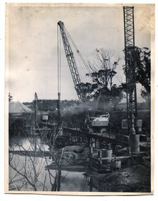
These are photographs of the construction of the current cement road bridge across the Snowy River at Orbost. Construction of the bridges commenced in January 1975, with an expectation to open the bridge across the Snowy River as soon as possible. Less than two years later, on 25 November 1976, the bridge across the Snowy River was opened to traffic, allowing the old bridge to be demolished. The remainder of the Orbost Bypass, both the floodplain crossings and the eastern section around the township itself, was declared ‘Princes Freeway’ and opened to traffic in December 1977. (ref http://mrv.ozroads.com.au)The opening of this Snowy River Bridge was an important development in the accessibility to the township of Orbost. These photographs record its construction.Two black / white photographs showing the construction of a road bridge across a river. 3257.1 shows piles being dropped beside the bridge, 3257.2 is of the early stages of construction of this bridge.snowy-river-bridge-orbost road-construction-orbost bridge-orbost -
 Surrey Hills Historical Society Collection
Photograph, Denholm's Garage, 209 Union Road, Surrey Hills
Fred Lyons (cab driver) and Dave Denholm (garage proprietor) worked together in a business servicing cars and providing vehicles for weddings etc. The photo came as part of a donation of photos related to Fred Lyons, his family and business. The building and automotive business was taken over and became J & V Warren-Smith Auto Service. In 2018 it is managed by John and Val's son Phillip and is believed to be the only business in the Union Road shops with a continuous history of use.A back and white photograph of a garage called Union Motor Garage. It has a brick facade, with an arched window either side of the driveway. A petrol bowser stands in front of each window. There is a car in the driveway.On small card: Union Motor Garage / D. B. Denholm, Proptr. / 209 UNION ROAD, SURREY HILLS / Phone Box Hill 959 / AUSTIN OAKLAND / PONTIAC DOUGLAS.::denholm's garage, union motor garage, union road, surrey hills, (mr) dave b. denholm, (mr) fred lyons, petrol stations, petrol pumps, j & v warren-smith auto service -
 Melbourne Tram Museum
Magazine, I.F. Brander, 75 Waverley Road, East Malvern, "Melbourne Olympic City", c1956
Newspaper titled: "Melbourne Olympic City", containing on page 7, an advertisement for the State Savings Bank of Victoria. Ad features an unidentified tram in front of the Elizabeth St head office. Printed and published by I.F. Brander, 75 Waverley Road, East Malvern, for The Argus & Australasian Ltd, at the Reg Office, 365 Elizabeth St Melbournetrams, tramways, w class, elizabeth st -
 Kew Historical Society Inc
Photograph, J F C Farquhar, Studley Park Road, 1891
At the beginning of the 1890s, the Kew businessman and Town Councillor, Henry Kellett, commissioned J.F.C. Farquhar to photograph scenes of Kew. These scenes included panoramas as well as pastoral scenes. The resulting set of twelve photographs was assembled in an album, Kew Where We Live, from which customers could select images for purchase.The preamble to the album describes that the photographs used the ‘argentic bromide’ process, now more commonly known as the gelatine silver process. This form of dry plate photography allowed for the negatives to be kept for weeks before processing, hence its value in landscape photography. The resulting images were considered to be finely grained and everlasting. Evidence of the success of Henry Kellett’s venture can be seen today, in that some of the photographs are held in national collections.It is believed that the Kew Historical Society’s copy of the Kellett album is unique and that the photographs in the book were the first copies taken from the original plates. It is the first and most important series of images produced about Kew. The individual images have proved essential in identifying buildings and places of heritage value in the district.In this view of Studley Park Road, looking northeast to the Junction, the photographer invites the viewer to participate in a point-of-view that emphasises the elevated, tranquil vantage point of the hill in contrast to the bustling commercial area in the distance. The view emphasises the exclusiveness of Studley Park, with its high fences behind which a number of significant Kew mansions were concealed. Contemporary advertisements for the sale of mansions in Studley Park Road often included fulsome descriptions of their elaborate formal gardens, as well as paddocks for grazing, stabling and dairies. None can be seen here. The use of high, protective wooden pickets to surround the newly planted avenue of elms on the south side of the road appears to be typical of the period. Similar examples can be seen in early photographs of Wellington and Princess Streets.The horse and carriage, selected as a central focus of the view, reinforces the residential, exclusive nature of this part of Kew in the early 1890s. Studley Park Roadkew illustrated, kew where we live, photographic books, henry kellett -
 Lara RSL Sub Branch
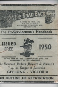
Handbook, W.A.Cooney, The Road Back, 1947/1950
The handbook was distributed to all ex-servicemen on return from WW2 in the Geelong area and was a guide to civil life.This booklet for returned service personnel from World War 2 living in the Geelong Region is og local district significance as a part of the history of Geelong.The Road Back -two of The Ex-Serviceman's Handbooks,1947/ 1950 Geelong Issued Free.One is Light green in colour with black writingThe Road Back The Ex-Serviceman's Handbook Geelong.the road back, the ex-serviceman's handbook, world war 2, ww2, australian aif, australian serviceman, australian servicewoman, rss&aila, army, navy, air force, returned sailor's, soldier's and airmen's imperial league of australia, rsl -
 Whitehorse Historical Society Inc.
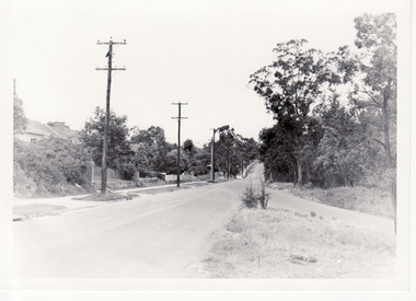
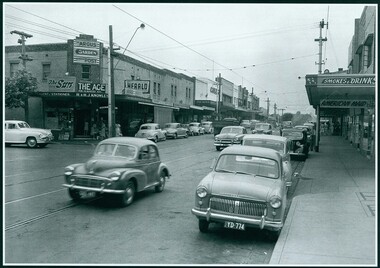
Photograph, Blackburn Road Looking South, 1960
Black and white photograph of Blackburn Road looking south from Canterbury Road in January 1960. Note lampposts and made footpath on the left side.blackburn road, canterbury road -
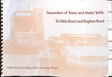 Melbourne Tram Museum
Document, Melbourne & Metropolitan Tramways Board (MMTB), "Separation of Trams and Motor Traffic - St Kilda Road and Brighton Road", May 1979
Document prepared to provide the concepts for separation of traffic along St Kilda Road and Brighton Road using safety bars, and reserved sections of roadway between Princes Bridge and Glen Huntly Road. Dated May 1979. Has an introduction, and notes the widening of St Kilda Road south of Cochrane St and its impact. Has colour photo of Z89 in Nicholson St where the Safety bars had been installed to separate traffic, installation of Safety Zones, photos of Gothenburg, Amsterdam, and Hanover showing traffic separation, graphs showing tram passenger movement in the am peak and road usage. Looks extensively at the Domain Interchange at Park and Domain Road and the suggested layout - which was implemented in Nov. 1986. Includes a photo of a very long line of trams northbound at this intersection which has undergone many changes location, to become during 2025 the entry to Anzac station. Six drawings show the proposed separation of traffic between Alexandra Ave and Glen Huntly RoadDemonstrates a planning document to separate road traffic from trams along St Kilda Road.Comb bound document titled "Separation of Trams and Motor Traffic - St Kilda Road and Brighton Road" - 12 sheets + card covers, some full colour pages with some sheets folded.tramways, st kilda road, traffic control, domain interchange, domain road, reserved track -
 Camberwell Historical Society
Photograph, Camberwell, Victoria, looking south down Burke Road in Camberwell, c. 1950
Print of photograph looking south down Burke Road. Inscription 'Camberwell, Victoria, looking north down Burke Road in Camberwell c. 1950' which is actually incorrect because it is looking south. Camberwell, Victoria, looking north down Burke Road in Camberwell c. 1950camberwell -
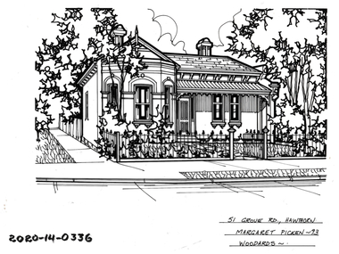 Hawthorn Historical Society
Drawing - Property Illustration, 51 Grove Road, Hawthorn, 1993
'After training as a Cartographic Draftsman within the mining industry, I worked as a property illustrator for real estate firms in the eastern suburbs of Melbourne for 23 years from 1983. I initially photographed houses with a Polaroid camera and made a 'thumbnail' sketch while there. The photos were used to scale off a sketch in pencil and then that sketch was overlaid with drafting film and the 'pen and ink' completed. The pens I used were the Rotring ‘Rapidigraph’ drafting pens. The ink was also made by Rotring (German).The film was ‘Rapidraw’, polyester drafting film, double matte. It takes a very fine line and doesn’t bleed. As well as house sketches, there were often floor plans and site plans ordered. Aerial sketches were ordered when the property needed an overall view.' (Margaret Picken, 2020)This property illustration is one of a series created by Margaret Picken for a range of real estate agents in Melbourne between c. 1983 and c. 2006. Each work is signed and dated by the artist.Gift of Margaret Picken, 2020Pen and ink property illustration on drafting film of 51 Grove Road, Hawthorn by Margaret Picken.51 Grove Road, Hawthorn, Margaret Picken '93. Woodards. artist - margaret picken 1950- -
 Whitehorse Historical Society Inc.
Photograph, 217 Whitehorse Road, Blackburn, 1/08/1998 12:00:00 AM
Coloured photo of 217 Whitehorse Road, Blackburn.whitehorse road, blackburn, no.217. -
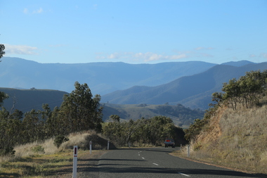 Ballarat Heritage Services
Digital Photograph, Road Near Omeo, Victoria, 2017
Colour photograph of the road near Omeo, Victoria.2017, great alpine road, omeo high plains, omeo, australian alps, high country -
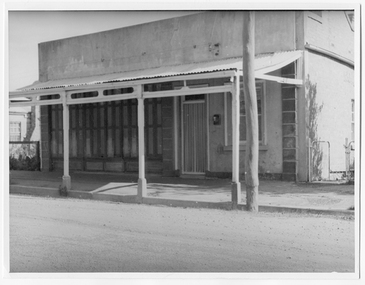 Tarnagulla History Archive
Photograph looking down Commercial Road, Tarnagulla, Looking down Commercial Road, Tarnagulla, c.1960s
Murray Comrie Collection. Shopfront located on west side of Commercial Rd between King and Poverty Streets. Original print.Monochrome photograph of a shopfront in Commercial Road, Tarnagulla. tarnagulla, buildings, businesses, commercial road -
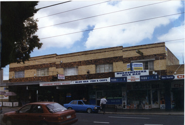 Glen Eira Historical Society
Photograph, Murrumbeena Road, 229-229A-231-231A-233, Murrumbeena, 2001
Originally labelled "Beauville Estate, Established 1936, Still Thriving 65 years on, 10th March 2001", the Beauville Estate Album contains colour photographs of houses in the Estate. They were taken around the time of the Beauville Estate’s 65th Heritage Celebration held on 10/03/2001 and donated to the Caulfield Historical Society shortly afterwards. Photographer unknown. 227 Murrumbeena Road (Bev Baxter Chemist) is not part of HO12.City of Glen Eira’s Heritage Management Plan Vol 2 p79 (this is p84 of the pdf version) – HO12 Beauville Estate and environs, Murrumbeena: The Beauville Historic Area is important at the State level as the first large housing estate undertaken by the AV Jennings Construction Co, later Jennings Group Limited, Victoria’s largest home builder. It is important also as a very early estate development incorporating a range of features other than houses and including made roads, shops and recreation facilities. In this respect it was the forerunner of the comprehensively planned housing estate of the post war era. The estate is distinguished by its aesthetic values, as is the earlier and comparable Hillcrest Estate, which are formed by a combination of restrained diversity in house styles, with the exception of no. 30 in the emerging International style, and by a landscaped garden environment. Colour photograph of a group of commercial properties with ground level shops and upper level two toned brown, unpainted brick residences. The photograph taken from across the road also includes parked cars, a person leaning on a car outside the fish and chip shop and a pedestrian crossing the road. Shops shown are from left to right: Cafe Fresca, 231 Hair Creations, Leovorno Pizza, Blue Sea Fish & Chips, Murrembeena (sic) Milk Bar and a portion of the one storey shop Bev Baxter Chemist at the right end. LEOVORNO PIZZA / BLUE SEA FISH & CHIP / Herald Sun / Sunday / MURREMBEENA MILK BAR / PK's / SANDWICH BAR / Bev Baxtermurrumbeena, architectural styles, 1930's, inter war style, a.v. jennings, av jennings, jennings, beauville estate, murrumbeena road, commercial establishments, shops, pharmacies, milk bars, fish shops, sir albert victor jennings, a v jennings construction co, beauville estate heritage area, glen eira city council, architectural features, jennings group limited, land subdivision, beauville historic area, brick shops, brick features, hairdressers, pizza shops, restaurants -
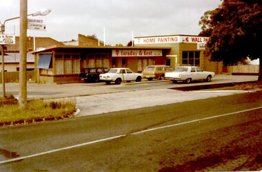 Surrey Hills Historical Society Collection
Photograph, Faraday & Kent, 172 Union Road Surrey Hills, 1979
This site was previously occupied by a Golden Fleece petrol station and later by Cobb & CO car rental. In Paul Towers bought the property from Faraday & Kent, for whom Norm Henderson was the proprietor, in 1996. In 2003 it was bought by Evan Lewis. (NOTE re source: undated note re verbal history given by un-named person).A colour photograph of the corner of Guildford Road and Union Road. There are four cars parked in front of a building. There is a sign identifying Faraday & Kent - home painting and wallpaper.guildford road, surrey hills, faraday & kent, businesses, paint shop, union road, norman henderson, evan lewis, paul towers, norm henderson -
 Glen Eira Historical Society
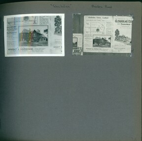
Album - Album page, Glenholme, Bambra Road, Circa 1972
This photograph is part of the Caulfield Historical Album 1972, showing an advertisement for the 21/04/1923 Glenholme Estate sale through real estate agents Knight and Harwood. This album was created in approximately 1972 as part of a project by the Caulfield Historical Society to assist in identifying buildings worthy of preservation. The album is related to a Survey the Caulfield Historical Society developed in collaboration with the National Trust of Australia (Victoria) and Caulfield City Council to identify historic buildings within the City of Caulfield that warranted the protection of a National Trust Classification. Principal photographer thought to be Trevor Hart, member of Caulfield Historical Society. Most photographs were taken between 1966-1972 with a small number of photographs being older and from unknown sources. All photographs are black and white except where stated, with 386 photographs over 198 pages. This polychrome brick and slate-roofed mansion was built by John Hart in 1871. Later owned by James McDougall (partner in Sands and McDougall; director of the first Caulfield horse tram company). Later again, it became a psychiatric hospital; demolished c1923.Page 36 of Photograph Album with two photographs of Glenholme Estate advertisements.Handwritten: "Glenholme" Bambra Road [top] / 36 [bottom right]trevor hart, caulfield north, bambra road, glenholme, advertisements, glenholme estate, knight and harwood, real estate agents, maps, polychrome bricks, slate roofs, john hart, james mcdougall, psychiatric hospitals -
 Orbost & District Historical Society
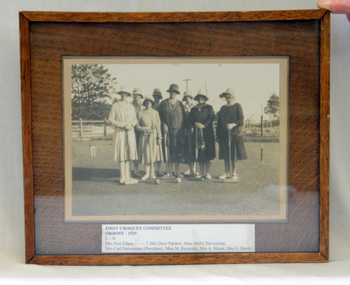
framed photograph
First croquet committee in Orbost started up in 1919. (ref : The Whos' Who of Orbost Settlers - Mary Gilbert). Often croquet lawns were in private gardens eg. at Connort (now Moogji). (Date on photograph?)This item is part of the history of Orbost Croquet Club. In the museum, there is also a mallet, a trophy and a photo of the first committee.A framed black/white photograph. It is of six women standing on a croquet lawn holding mallets. All are wearing hats. The frame is brown wood.On a glued sheet of paper - First Croquet Committee Orbost - 1929 Mrs Neil Edgar..........Mrs Dave Pardew Mrs Molly Dreverman Mrs Carl Dreverman (President) Miss M. Reynolds Mrs A. Nixon Mrs G. Hovey -
 Phillip Island and District Historical Society Inc.
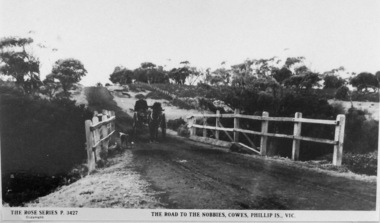
Photographs, The Road to The Nobbies, Phillip Island
Part of a collection of 'Rose & Valentine' series of Post Cards. Copied by John Jansson 1984Black & White Postcard. View of the Nobbies Road with horse and trap about to cross bridge.The Rose Series No. 3427. The Road to The Nobbies, Cowes, Phillip Island, Victorialocal history, photography, photographs, postcards, black & white postcard copy, the nobbies, nobbies road, phillip island -
 Orbost & District Historical Society
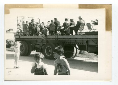
black and white photograph, October 4 1978
From the Snowy River Mail October 4 1978 page 9 - " A MOBILE BAND - Although Orbost Municipal Band participated in Saturday's Primary School workathon, members feet didn't touch the ground. They idi it bthe easywayon the trailer of a truck. The band encouraged walkers with stirring music along the road to Marlo." The first Orbost Brass Band was formed in 1889. Around 1908 the town band split and the Orbost Workers' Band was formed. Eventually the two bands merged in 1913 to reform as the Orbost Municipal Band under conductorship of Charles Spink. The band continued for many years but was later disbanded and again reformed. This was to happen a number of times, the last time being in 1961 and continuing through to the late 1970's. Further info and Ref: In Times Gone By - Deborah Hall This is a pictorial record of the Orbost Municipal Band. The various Orbost bands over the years played a major role in community activities providing entertainment and musical experiences for the many members.A black / white photograph showing a group of uniformed band members sitting on folding chair s on the tray of a large flat bed truck. They are holding musical instruments. A young boy is sitting on the edge of the tray and three other children are standing on the road nearby.on back - information from S.R.M.music orbost-municipal-band entertainment recreation -
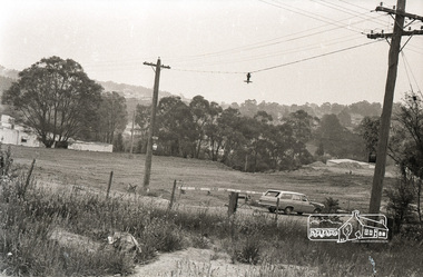
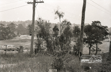
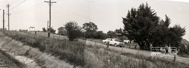
 Eltham District Historical Society Inc
Photograph, Sherbourne Road, Para Road and Simms Road at Briar Hill, 3 November 1967, 3 Nov 1967
Viewed from railway line opposite Graham Body Works. Simms Road is running to the right in front of the old house. The house belongs to Mrs Cameron whose daughter married a DAVEY after which Davey Street is named. Excavation work is being undertaken for the realignment of the Para Road and Sherbourne Road intersection where the current roundabout is located, approximately where the two cars are parked. Mrs Cameron's house and the other are where Montmorency Secondary College is situated. The school opened in 1969.Roll of 35mm black and white negative film, 6 strips Ilford HP3briar hill, cameron, davey, davey road, graham body works, greensborough, montmorency secondary college, sherbourne road, simms road -
 Eltham District Historical Society Inc
Photograph, Sherbourne Road, Para Road and Simms Road at Briar Hill, 3 November 1967, 3 Nov 1967
Viewed from railway line opposite Graham Body Works. Simms Road is running to the right in front of the old house. The house belongs to Mrs Cameron whose daughter married a DAVEY after which Davey Street is named. Excavation work is being undertaken for the realignment of the Para Road and Sherbourne Road intersection where the current roundabout is located, approximately where the two cars are parked. Mrs Cameron's house and the other are where Montmorency Secondary College is situated. The school opened in 1969.Photostitch from multiple images on roll of film. Roll of 35mm black and white negative film, 6 strips Ilford HP3briar hill, cameron, davey, davey road, graham body works, greensborough, montmorency secondary college, sherbourne road, simms road -
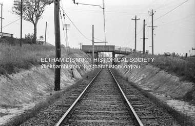 Eltham District Historical Society Inc
Photograph, Railway overpass on Sherbourne Road at junction of Para Road and Simms Road, Briar Hill, 3 November, 1967
Viewed from railway line opposite Graham Body Works. Simms Road is running to the right in front of the old house. The house belongs to Mrs Cameron whose daughter married a DAVEY after which Davey Street is named. Excavation work is being undertaken for the realignment of the Para Road and Sherbourne Road intersection where the current roundabout is located, approximately where the two cars are parked. Mrs Cameron's house and the other are where Montmorency Secondary College is situated. The school opened in 1969.Roll of 35mm black and white negative film, 6 strips Ilford HP3briar hill, cameron, davey, davey road, graham body works, greensborough, montmorency secondary college, sherbourne road, simms road -
 Camberwell Historical Society
Photograph, Camberwell, Victoria, view of Toorak Road and stores, c. 1950
Print of photograph of Middle Camberwell with inscription 'Camberwell, Victoria, view of Toorak road and stores, c. 1950' Camberwell, Victoria, view of Toorak road and stores, c. 1950camberwell -
 Whitehorse Historical Society Inc.
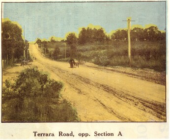
Photograph, Terrara Road Vermont
Terrara Road Vermont . Countryside uncultivated and road unmadeHand coloured black and white photograph of Terrara Road Vermont showing dirt road and one buggy. terrera road, vermont -
 Surrey Hills Historical Society Collection
Photograph, 34 Union Road, Surrey Hills - home of the Kleinert family
This was built in 1905 and was the home of William and Emily Kleinert from 1905. William was a coach-builder, wheelwright and blacksmith. He moved from Prahran to Surrey Hills. His son Ernest worked with him as a coach painter and also worked as a painter undertaking intricate hand painting on early cars. Their other son Martin played for the Surrey Hills Football Club. In return for the support given to the club by Mrs Emily Kleinert, the club built a rotunda in South Surrey Park as a memorial to her. Alan Holt research: Lot 6 was sold to Martin Kleinert by Karl Richter in 1860 together with a portion of another adjacent lot. From 1860-1885 Martin worked it as a market garden leasing some land for grazing when it was not required for gardening. He died in 1898. In a formal document, William declared he was the son of Martin "who purchased land in 1860, died in 1898 and the land has been continually occupied by father and family since. It has been cultivated as a market garden; when not being used for gardening it was let for cultivation and grazing." William died in 1939 and the property passed to his sons Martin and Ernest. The Kleinert land extended from Union Road to Essex Road. They ran horses, ducks and fowls and Emily Kleinert grew flowers. The Kleinert property later became the South Surrey Park. The family sold the land to the Camberwell Council in the 1950s. Ernest and Ida Kleinert lived on the corner of Scotsdale and Warrigal Roads. The donor of the photo Nada Harris, nee Kleinert, was Ernest and Ida's daughter. Ida lived to a good age (> 93 years) and in later life lived in Burwood.Black and white photo of a Victorian cottage with a typical bull-nosed veranda. It is set behind a wooden picket fence with undeveloped grazing land studded with mature trees in the background. Taken front-on from the street. There appears to be a path but no formal curb to the road.south surrey park, union road, surrey hills football club, blacksmiths, wheelwrights, coachbuilders, rotunda, miss nada kleinert, mr william kleinert, mrs emily kleinert, mr martin kleinert, mr ernest kleinert, mr karl richter, mrs ida de vasy, mrs nada harris -
 Whitehorse Historical Society Inc.
Photograph, House at 451 Mitcham Road, Mitcham
Coloured photo of House at 451 Mitcham Road, Mitcham.mitcham road, mitcham, no. 451