Showing 761 items
matching planning paper
-
 University of Melbourne, Burnley Campus Archives
Plan, 25 Wakanui Street, 1996
Plans for a garden at 25 Wakanui Street [Northcote] by Holmes Design. (1) Point Location Data showing plumbing fixtures. (2) Tracing paper and paper copies Dwg No 13 Site Inventory & Analysis 4/6/96. Scale 1:100. (3) Coloured tracing paper and paper copies, Dwg No 15 Preliminary Plan 6/6/96. Scale 1:100. (4) Tracing paper and paper copies Dwg No 16 Section View Backyard 6/6/96. Scale 1:50. (5) Photocopy of Certificate of Title and Sewerage.wakanui street, holmes design, northcote, garden design -
 Merbein District Historical Society
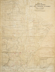
Plan - Plan, Allotments, Plan of Homestead Allotments White Cliffs Irrigation Settlement Parish of Merbein County of Karkarooc
Large plan drawn in black ink on cream colour paper with linen backing. Some red ink addedWritten in red pen new owners of allotmentsallotments, merbein, irrigation, whitecliffs, county of karkarooc -
University of Melbourne, Burnley Campus Archives
Plan, Mont Calm, 1995
Plans for Garden Courtyard in a residential home, "Mont Calm," Prospect Hill Road, Surrey Hills. Student assignment dated 13.02.1995. (1) Assignment details. (2) Student rough notes. (3) Outline on tracing paper. (4) Rough sketch. (5) "Paving to Northern Courtyard."mont calm, surrey hills, garden design, courtyard garden -
University of Melbourne, Burnley Campus Archives
Plan, Atrium Planting, 1991
Student assignmentTracing paper copy of Plant Materials III Assignment 1991.atrium planting, planter box, garden design -
 Ballarat Tramway Museum
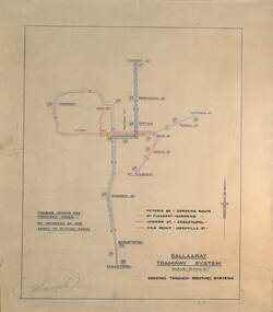
Drawing - Proposed Fares, State Electricity Commission of Victoria (SECV), "Ballaarat Tramway System", 1949
The plan prepared by the SECV shows proposed fares, an increase of 1d on existing fares, and the through routing of tram services. Scale of 40 chains to 1". Alligns with August 1949 Fare By-Law - see item 3111. See also the pdf file "Ballarat Tramway Fares Changes SEC Era", by Warren Doubleday, 03-09-2006.Demonstrates aspects of the way the SEC prepared plans showing tram and ticketing arrangements.Plan titled "Ballaarat Tramway System" - multi-coloured on paper with pencil notations.tramways, ballarat, secv rules, by-laws, tickets, fares -
 Melbourne Tram Museum
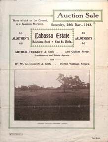
Ephemera - Real estate sale, Arthur Tucett & Son, "Labassa Estate" - Balaclava Road, East St Kilda, Nov. 1913
... coloured paper with photographs and plans.... in two colours of cream coloured paper with photographs and plans ...Pamphlet advertising the sale of land at the Labassa Estate, Balaclava Road 29-11-1913. Promotes the tram service, St Kilda Esplanade with a photo of PMTT 15 at the entry to Labassa at the corner of Orrong Road and Balaclava Road. Has a plan for the sub-division in to 46 allotments, terms of sale, and restrictions of what could be built on the land. The original Labassia Mansion is now owned by the National Trust.Demonstrates the style of land sale pamphlet including the availability of tram services to prospective purchasers.Pamphlet - folded - printed in two colours of cream coloured paper with photographs and plans.sale of land, trams, balaclava, balaclava road, real estate, labassa, orrong road -
 Melbourne Tram Museum
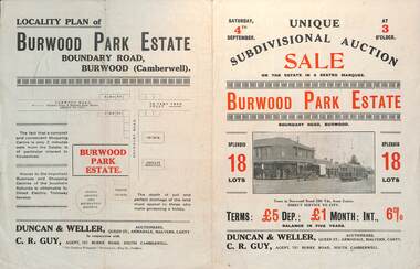
Ephemera - Real estate sale, Duncan & Weller Auctioneers, "Burwood Park Estate" Boundary Road, 1926
... coloured paper with photographs and plans.... coloured paper with photographs and plans. "Burwood Park Estate ...Pamphlet advertising the sale of land at the Burwood Park Estate, Boundary Road Burwood, Saturday 4th September. Does not give the year, most likely 1926. Promotes the tram service, nearby shops, the suitability of the soil for gardening and other facilities. Has a photo of possibly W 259 at the terminus. The plan of sub-division shows 18 lots for sale.Demonstrates the style of land sale pamphlet including the availability of tram services to prospective purchasers.Pamphlet - folded - printed in two colours of cream coloured paper with photographs and plans.sale of land, trams, real estate, burwood park, burwood -
 Melbourne Tram Museum
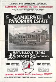
Ephemera - Real estate sale, Cranny Sambell & Co, "Camberwell Panorama Estate", Oct. 1923
... coloured paper with photographs and plans.... to the corner. This extension took place in 1937. The locality plan ...Pamphlet advertising the sale of land at the "Camberwell Panorama Estate" - Doncaster and Bulleen Road 13-10-1923. Gives terms of sale, photos showing the views and a nearby shopping centre. Has a large photo of MMTB No. 20 on the front cover. The tramcar is of the Hawthorn Tramways Trust four-door bogie type. MMTB No 20 was an ex-Prahran and Malvern single trucker or small tram A class. Gives details of the 110 lots to be sold, terms, location, and that the tram was proposed to be extended to the corner. This extension took place in 1937. The locality plan shows proposed plans for tram lines in Belmore Road and Burke Road north of Whitehorse Road. Demonstrates the style of land sale pamphlet including the availability of tram services to prospective purchasers.Pamphlet - folded - printed in two colours of cream coloured paper with photographs and plans.has pencil notes on the top of the front page.sale of land, trams, real estate, camberwell panorama estate, east camberwell, doncaster road, bulleen road, tram 20 -
 Melbourne Tram Museum
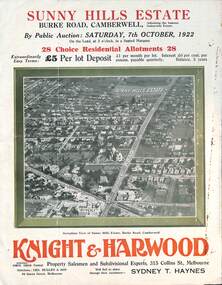
Ephemera - Real estate sale, Knight Harwood, "Sunny Hills Estate" - Burke Road Camberwell, Oct. 1922
... coloured paper with photographs and plans.... of cream coloured paper with photographs and plans. "Sunny Hills ...Pamphlet advertising the sale of land at the "Sunny Hills Estate" Burke Road Camberwell 7-10-1922. Gives terms of sale, photos showing a nearby shopping centre, recently constructed houses, and plan of the subdivision. Land prices have been written in for each block on the pamphlet. Has a photo featuring Camberwell Junction with a tram, and Burke Road view with trams. Demonstrates the style of land sale pamphlet including the availability of tram services to prospective purchasers.Pamphlet - folded - printed in three colours of cream coloured paper with photographs and plans.has ink notes re sale price and notes.sale of land, trams, real estate, burke road, camberwell, sunny hills estate -
 Melbourne Tram Museum
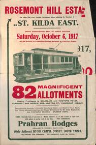
Ephemera - Real estate sale, Prahran Hodges, "Rosemont Hill Estate", Oct. 1917
... coloured paper with photographs and plans.... of cream coloured paper with photographs and plans. "Rosemont Hill ...Pamphlet advertising the sale of land at the "Rosemont Hill Estate", Balaclava Road, St Kilda East, 6-10-1917. On the front cover has a photo of PMTT tram No. 27. Gives terms of sale, the plan of the subdivision, and a general locality plan showing tram and rail lines. Land prices have been written in for some blocks on the pamphlet. Demonstrates the style of land sale pamphlet including the availability of tram services to prospective purchasers.Pamphlet - folded - printed in two colours of cream coloured paper with photographs and plans.has pencil notes re sale price and notes for some blocks.sale of land, trams, real estate, balaclava road, st kilda east, pmtt, tram 27, rosemont hill estate -
 Bacchus Marsh & District Historical Society
Map, Tracing of plan shewing portion through Bacchus Marsh District of proposed new Main Road between Gisborne and Blackwood
Road construction and planning was a primary function of the early local government authorities in rural and regional Victoria. This plan is indicative of the sort of documentation which generated considerable public interest and comment in rural communities. The date of this plan is not clear. Newspaper articles in the Bacchus Marsh Express around 1869 contain numerous references to the proposed new road between Gisborne and Blackwood which suggests this plan may date from the late 1860s or early 1870s.A single page paper map showing the proposed route of a main road to be constructed between Gisborne and Blackwood. The map is pasted into a bound volume containing 76 maps or plans in total. High resolution digital image stored on BMDHS computer network. roads, road plans, bacchus marsh victoria maps, gisborne to blackwood main road -
 Bacchus Marsh & District Historical Society
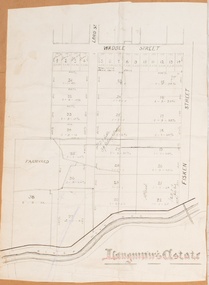
Map, Langmann's Estate Bacchus Marsh
The date of this map has not been determined. It bears the signature of D.A. Little upon of a portion of the map. Little was Bacchus Marsh Shire Secretary and Engineer between 1886 and 1914 which dates the map to some time between 1886 and 1914.A single page paper map showing a portions of land in part of Bacchus Marsh.The area shown is described as Langmann's Estate. The area is bounded by the Werribee River, Fisken Street, Waddle Street(sic.) (Waddell) and Lord Street. The map is pasted into a bound volume containing 76 maps or plans in total. High resolution digital image stored on BMDHS computer network. interim map record stage 1, bacchus marsh victoria maps -
University of Melbourne, Burnley Campus Archives
Plan, Emerald Environmental Horticulture Annexe VCAH Burnley, 1992-1996
... (1) Tracing paper Sketch. Scale 1:500 dated 26.7.96 drawn... and tracing paper copies, "Proposed Concept Plan for Development." (5 ...In 2012 was owned by John Rayner who purchased site from The University of Melbourne in c2006.(1) Tracing paper Sketch. Scale 1:500 dated 26.7.96 drawn by JK (Jill Kellow, Staff). (2) Tracing paper and paper copies, "Proposed Location of Toilet Facility and Septic System." Scale 1:500. (3) Tracing paper copy ,"Revegetation Program Works 1993/94." Scale 1:500. (4) Coloured laminated and tracing paper copies, "Proposed Concept Plan for Development." (5) Tracing paper and paper copies of labelled sketch. Scale 1:500. (6) Proposed Development 1994-95 - List of Proposed New Works. (7) Tracing paper and paper copies, Existing Ornamental Plants, Drawing No E1 drawn by J.J.W. 1.8.92. Scale 1:100. (8) Proposed Amenities Block at Lot Charman Ave, Emerald 3782 by Belgraphic. Drawn by Rosemarie, Plan No 93 003 tp March 1993. Scale 1:50. emerald, john rayner, jill kellow, vcah burnley -
University of Melbourne, Burnley Campus Archives
Plan, The Museum of Modern Art at Heide, 1995
... and 1 paper reduced size, Sketch Plan. Scale 1:1000. Drawn by JK... paper and 1 paper reduced size, Sketch Plan. Scale 1:1000. Drawn ...(1) Photocopy of Herb and Plant Location Map, Heide Kitchen Garden, plants numbered, no legend. (2) 1 tracing paper, 1 paper and 1 paper reduced size, Sketch Plan. Scale 1:1000. Drawn by JK (Jill Kellow, Staff) 06.06.1995. (3) Photocopy of Heide Park and Art Gallery Grounds and Planting. Numbered Plant List, 1 Trees, 2 Shrubs.heide, museum of modern art, gardens, jill kellow, bulleen, kitchen garden -
University of Melbourne, Burnley Campus Archives
Plan, Barkly Gardens, c. 1980
... (1) Plan of park drawn in pencil on tracing paper. (2) 2... paper and 1 original on paper with 3 copies, plan by City ...(1) Plan of park drawn in pencil on tracing paper. (2) 2 copies on tracing paper and 1 original on paper with 3 copies, plan by City of Richmond City Engineers Department.barkly gardens, city of richmond, urban landscapes -
 Bendigo Historical Society Inc.
Document - BASIL MILLER COLLECTION: MAP - CHARING CROSS
Map showing Charing Cross, Bendigo area. Details written suggest plans for an ANZAC Day Service. Cream coloured paper and black print with additions written by hand in blue ink. Numerous markings in blue ink on front. 'the Manager, SEC, Hargreaves Street Bendigo, ref. Tramways' on reverse.basil miller, bendigo trams, state electricity -
University of Melbourne, Burnley Campus Archives
Plan, RMIT Mill Park Campus, 1995
Tracing paper copy, Landscape III Assignment 1995. Scale 1:500.mill park campus, student assignment, rmit -
University of Melbourne, Burnley Campus Archives
Plan - Sketch, The Pergola at Balmoral, 1980s?
Coloured perspective sketch on tracing paper.pergola, balmoral -
 Bendigo Historical Society Inc.
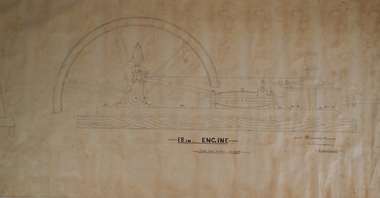
Plan - HORWOOD COLLECTION: DRAWINGS FOR CONSTRUCTION OF 18'' ENGINE
... foot' Plan drawn in fine black pen on waxed paper. Plan HORWOOD ...Engineers plan for an 18 '' engine. Written on bottom 'J. Horwood and Sons, Engineers, Sandhurst. 18 IN Engine, Scale one inch = one foot' Plan drawn in fine black pen on waxed paper.bendigo, industry, horwood, foundry, mining equipment -
 Flagstaff Hill Maritime Museum and Village
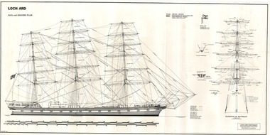
Document - Ship Model Plans, Loch Ard, October 1977
These two framed model ship plans are from more than 650 produced for the LOCH ARD Centenary (1878-1978) Commemoration Committee. These plans were originally researched, designed and distributed in 1977 to assist entrants in the Committee’s Ship Model Competition. The competition was arranged as a means of creating public interest and awareness for the 100th anniversary of the tragic LOCH ARD shipwreck on Victoria’s south west coast in 1878. The main subject specified for modelling was “The Loch Ard ― Iron Wool Clipper 1873”. “The plans were drawn by Mr P Webb to the order of the Committee through Mr P Williams, organizer of the competition. The details were based on all available information which resulted in considerable historical research…and received favourable comment from model makers because of their attention to detail…In excess of 650 sets of plans were sold before entries closed…Many plans were probably purchased by collectors and interested persons for historical reference. An illustrated historical story sheet…was prepared and enclosed with the plans…” (‘Loch Ard Shipwreck Centenary 1878-1978 Report’, November 1978). An example of the attention to historical detail delivered on the plans is the inclusion of the following useful information about the original vessel: “Tonnage….1,693 G.R.T., 1,624 N.R.T. Builders….Charles Connell & Co., Ltd., Scotstoun, 1873. Owners….General Shipping Co., Glasgow, (Aitken Lilburn & Co., Ltd.)”. The quality of research and drafting makes these framed copies of considerable interpretive value to related items from the LOCH ARD shipwreck on display at Flagstaff Hill. They were originally mass produced but are now out of print. Flagstaff Hill retains other (unframed) copies in storage. The plans, in conjunction with the scale Ship Model of the LOCH ARD also on display, are of interpretive significance to Flagstaff Hill Maritime Village. The plans provide historical and technological context to artefacts from the shipwreck, increasing understanding and appreciation of those objects. Flagstaff Hill’s collection of artefacts from LOCH ARD is significant for being one of the largest collections of artefacts from this shipwreck in Victoria. It is significant for its association with the shipwreck, which is on the Victorian Heritage Register (VHR S417). The collection is significant because of the relationship between the objects, as together they have a high potential to interpret the story of the LOCH ARD. The LOCH ARD collection is archaeologically significant as the remains of a large international passenger and cargo ship. The LOCH ARD collection is historically significant for representing aspects of Victoria’s shipping history and its potential to interpret sub-theme 1.5 of Victoria’s Framework of Historical Themes (living with natural processes). The collection is also historically significant for its association with the LOCH ARD, which was one of the worst and best known shipwrecks in Victoria’s history. Two framed model ship plans of the LOCH ARD. These are detailed and researched plans from the original vessel, drawn to scale and printed on good quality paper, and framed behind glass to be hung on display. One slightly smaller plan “Lines, Decks and Details” portrays the hull lines as a body plan (straight on at the bow), a sheer plan (full side view), and a half breadth plan (a top-down view of deck to keel), as well as two top-down views of the upper decks and main deck with fittings and details of specific fixtures. One slightly larger “Sail and Rigging Plan” presents a side on, above deck view of masts and shrouds and a front on, above deck view showing “Elevation of Mainmast Looking Aft”. Each plan bears the draftsman’s initials and date of completion (“P.A.W. 10/77”). The larger plan also includes a boxed label attributing the project to the “LOCH ARD CENTENARY Commemoration Committee Ship Model Competition.”Smaller plan: heading “LOCH ARD: LINES, DECKS and DETAILS”; initials “P.A.W. 10/77”. Larger plan: heading “LOCH ARD: SAIL and RIGGING PLAN”; initials “P.A.W. 10/77”; label “LOCH ARD CENTENARY Commemorative Committee Ship Model Competition”. flagstaff hill, warrnambool, shipwrecked coast, flagstaff hill maritime museum, maritime museum, shipwreck coast, flagstaff hill maritime village, great ocean road, loch line, loch ard, captain gibbs, eva carmichael, tom pearce, glenample station, mutton bird island, loch ard gorge, ship model plans, loch ard model plans, sailing ship, loch ard centenary -
 Bacchus Marsh & District Historical Society
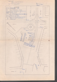
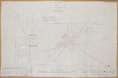
Map, Plan of the Village of Melton
... A single page paper map showing a plan for the village...Melton Victoria Maps A single page paper map showing a plan ...A single page paper map showing a plan for the village of Melton, Parish of Djerriwarrh, County of Bourke. The map is pasted into a bound volume containing 76 maps or plans in total. High resolution digital image stored on BMDHS computer network. melton victoria maps -
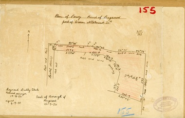 Ringwood and District Historical Society
Map, Plan of Survey, Parish of Ringwood - Part of Crown Allotment 31A - 1950
Hand drawn and labelled copy of map with survey measurements of allotment on Isobel Avenue (Isabel Avenue?), Ringwood East. Raymond Dudley Steele Licensed Surveyor 10-8-50, signed 6-9-50, Seal of Borough of Ringwood 26-9-50. Rubber stamp - Dugdale, Simmons & Stevens, Solicitors, Peacock House, 486 Bourke Street Melbourne. Typewritten heading on backing paper - Capt. M.H. Moyes - Correspondence Supplementary to Statements. -
University of Melbourne, Burnley Campus Archives
Plan, John S. Jenkins, Plan showing land required for Road Purposes from the temporary reservaton for Horticultural Gardens at Richmond, 1880
Plan drawn by hand on tracing paper by John S. Jenkins, Town Surveyor, Richmond. "The land required is coloured red & it is proposed to add the part of Swan Street coloured blue to the gardens." Plan depicts land required for road purposes from the temporary reservation for Horticultural Gardens at Richmond. (Also framed and glazed copy B92.0539.) Scanned on CD.john s. jenkins, gardens, richmond, hoticultural society of victoria -
University of Melbourne, Burnley Campus Archives
Book - Report, E.B. Littlejohn, Victoria 1944 State Regional Boundaries Committee Report on Regional Boundaries, 1944
See paper catalogue for complete contents. Item formerly property of E.B. LittlejohnReport includes maps of Regions for Planning and Development, geographical, weather, power, water resources, crops, livestock, etc.e.b. littlejohn, planning, development, regions -
 Bacchus Marsh & District Historical Society
Map, Atkins and Clarke Land Sale situate at Bacchus Marsh 1856 Copy 2
This plan of land allotments for sale indicates the property once owned by the Bacchus family in and around the township area of Bacchus Marsh. The Bacchus family sold their property in Bacchus Marsh to John Atkins and Robert Nalder Clarke in March 1851. Atkins and Clarke kept the property for a number of years until April 1856 when these allotments were put up for sale.This plan is almost identical to another copy held by the Bacchus Marsh and District Historical Society, VC Record 707, BMDHS collection). This plan, VC Record 452 Copy 2, contains a less detail than than VC Record 707 Copy 1. For example the selling agents and the surveyor who created the plan are not indicated on this copy of the plan. This copy of the plan does indicate the name Crook Street on the map. As the Crook family were the buyers of the Manor House property and surrounding land from Atkins and Clarke in 1856 it suggests that this copy is a later one of the earlier version. It is unlikely that the Crook family would have had the adjacent street named after them prior to purchasing the house and property. This is a very early land sales plan for the township of Bacchus Marsh and it therefore provides some clues as to how the early urban development of the township took place. Upon seeing the map in 1911 Bacchus Marsh Express newspaper editor Christopher Crisp wrote "The sale appears to have created the present township, which had a nucleus in earlier times further east", Express, 30 September, 1911, page 3. A single page paper map showing a portions of land available for sale in Bacchus Marsh in 1856. The subdivided land shown was owned by John Atkins and Robert Nalder Clarke, but previously owned by the Bacchus Family and was in and around their Manor House (Mansion) property in Bacchus Marsh.There are 5 portions of land further divided into numerous small portions. The land for sale is bounded by the present day streets of Main Street, Young Street, McFarland Street, Morton Streets, Crook Street, and part of the eastern section extends to the Lerderderg River. Scale: 4 chains to 1 inch. The map is pasted into a bound volume containing 76 maps or plans in total. High resolution digital image stored on BMDHS computer network. Plan of the first portion of land. The property of Messers Atkins and Clarke situate at Bacchus Marsh.land sales, land sales bacchus marsh, manor house bacchus marsh, crook family bacchus marsh -
 Bacchus Marsh & District Historical Society
Map, Allotments in the Village of Rowsley, Parish of Gorrocburkghap, County of Grant c.1856
Rowsley is a locality 11 kilometers south-west of Bacchus Marsh. The date of this map is uncertain. A very similar map held by the State Library of Victoria (SLV) contains slightly more information than this copy and is dated as an 1856 map. SLV reference: 'Allotments in the Village of Rowsley, Parish of Gorrocburkghap, County of Grant', by T. Nixon, Assistant Surveyor, May 1856 ; Surveyor General’s Office, July 18 1856 (lithographed by R. Meikle). (1856). Melbourne: Surveyor General’s Office. MAPS 820 BJE 1837- ROWSLEY 1856. A single page paper map. A cadastral map of the Village of Rowsley in Victoria, showing numbered land allotments. 57 allotments are shown on the map and some areas set aside as reserves. Allotments 8, and 10-16 are outlined in red ink and allotment 9 has a cross in red ink on it. The map is pasted into a bound volume containing 76 maps or plans in total. High resolution digital image stored on BMDHS computer network. rowsley victoria history, rowsley victoria maps -
University of Melbourne, Burnley Campus Archives
Plan, 'Burnley Park', 1987
Tracing paper copy dated July 1987. Landscape Graphics - Assignment One, 'Burnley Park' Site Plan. Scale 1:100. Includes contours and existing trees.burnley park, trees, landscape graphics -
 Bendigo Historical Society Inc.
Plan - PLAN OF 'TINTEN GLEN' GOLDEN SQUARE BY WILLIAM BEEBE
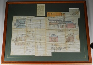
Plan of additions and alterations to house in Golden Square, Bendigo. Plan mounted on green board and framed in brown timber and glass. Plan shows front and side elevations and floor plan. House, called 'Tinten Glen' was owned by R. Saunders Esq. R. Saunders owned a store in High Street, Golden Square.Additions and alterations designed by William Beebe, Architect, Bendigo. On paper on top RH side " Wm Beebe, Architect, Williamson Street, Bendigo'. Top centre of framed item has a newspaper cutting displayed, detailing the auction of the house on Saturday 6th. May ( no year ). Date 1905, confirmed on digital newspaper.bendigo, buildings, tinten glen, golden square, william beebe -
 Warrnambool and District Historical Society Inc.
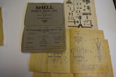
Documents, Atlas Automatic Fire Services Pty Ltd, Woollen Mill, late 20th century
... .1 A sheet of white paper showing a sketch plan in black... paper showing a sketch plan in black of the Warrnambool Woollen ...These items are from the Warrnambool Woollen Mill and relate to the fire protection services operating at the factory in the late 20th century. The Warrnambool Woollen Mill was commenced as a local public company and opened in 1910 in South Warrnambool with the first manager, John Bennett. During World War Two there were 700 employees at the mill due to wartime demand. In 1958 the factory became the first in Australia to manufacture electric blankets. In 1968 the mill was purchased by the Dunlop company and in 1982 Dunlop sold out to Onkaparinga Woollen Company which was taken over by Macquarie Worsteds and became known as Warrnambool Textiles. When Macquarie Worsteds ceased operations in Warrnambool the Smith Family managed the factory on behalf of the owners, the Warrnambool City Council. In 2000 the Woollen Mill closed and the site has been sold and developed as a housing estate.These items are of minor interest as mementoes of the Warrnambool Woollen Mill and will be added to the Woollen Mill collection in the Historical Society archives. .1 A sheet of white paper showing a sketch plan in black of the Warrnambool Woollen Mill with three areas coloured pink, yellow and blue .2 the same as .1 except that there are no shaded areas. .3 A sheet of lightweight card with black and yellow printing and a diagram of a machine Fire Plan For Insurance Purposes Atlas Automatic Fire Services Pty Ltd warrnambool woollen mill, history of warrnambool, onkaparinga woollen company, dunlop company -
 Melbourne Tram Museum
Film - Compact Diskette with video, Metlink, "Moving a Games City", 2006
DVD, with large format clear plastic cover with paper insert titled "Moving a Games City", sub-titled "A look at public transport during the Melbourne 2006 Commonwealth Games". Produced by Metlink, running time 17mins, has the games logo, Metlink., Yarra Trams, Connex, BusVic, VLine and Victorian Government logos on the rear. Features various elements of public transport access during the games, how they coped made changes, planning, Richmond station, Flinders St station, use of buses, passenger flows at Richmond, opening event, Ballarat station, VLine services, Doncaster Park and Ride and buses, Southbank depot, depot run outs, the Yarra Trams Fleet operations centre, Aquatic centre tram stops, St Kilda station, Southern Cross station, a very short segment of Z81, information campaigns, Metlink call centre, Rob Barnett of VLine, Dennis Cliche of Yarra trams, Peter Gibson of VLine, Digby Drew of Yarra Trams, John Stanley of BusVic, Mark Whitehead of VLine, Bernie Carolan of Metlink, Scott Martin of Dept. of Infrastructure, VLine, Mary Dimovski of Metlink, Andrew Kyriacou of Connex, Bruce Hughes of Connex.trams, tramways, commonwealth games, yarra trams, passenger services, metlink, connex, vline