Showing 3383 items
matching run
-
 Lakes Entrance Historical Society
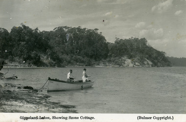
Postcard - Scone Cottage, Bulmer H D, 1930c
Second copy 16.5 x 25, speckly conditionFirst generation black and white postcard of two people fishing from a small boat moored on the shore at Gippsland Lakes. Also shows steep cliffs bordering lake, glimpse of Cliff Crest Tea Rooms, run by Mrs Westerson. Lakes Entrance VictoriaGippsland Lakes showing Scone Cottagetearoom, recreation -
 Melbourne Tram Museum
Document - Instruction, Metropolitan Transit Authority (MTA), "Metropolitan Transit Authority / Tram & Bus Division / Fleet Operations Centre", mid 1980's
Two page printed instruction titled "Metropolitan Transit Authority / Tram & Bus Division / Fleet Operations Centre", detailing how drivers could operate the system, testing, messages, how to contact the centre, emergency messages, explanations, passenger counts, run cards.trams, tramways, avm, automatic vehicle monitoring, mta, fleet operations centre -
 Kiewa Valley Historical Society
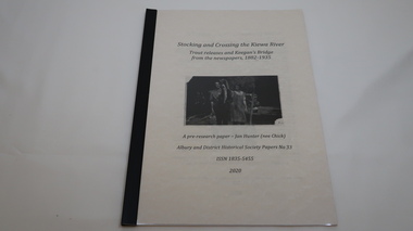
Book - Kiewa River, Stocking and Crossing the Kiewa River by Jan Hunter (nee Chick), 2020
The Chick brothers, Alf, Les and Allan, plus friends, began trout fishing and camping in the Kiewa Valley before the early 1930s. Les continued his connection with the Kiewa River until his death in 1972. Fingerlings were placed in the Kiewa River from the early 1880s. Keegan's Bridge is a crossing near Upper Gundowring and about 4 km south east of Dederang. References to the crossing were made in the early 1900s and a petition presented to Council in 1904 calling for a bridge.The bridge was built and opened in 1907. The photos are of the release of fingerling trout in the Kiewa River, thought to be at Keegan's Bridge. The fingerlings were transported in drums on the back of trucks. The photos are c1940s.The Kiewa Valley has been a popular spot for fishermen, tourists and campers from the 1880s. One of the many attractions has been the excellent fishing along the Kiewa River due to the regular release of fish especially brown trout. This continues to the present day (2020) when a few fish were marked with $$ signs for the lucky fisherman who caught them. This attracts visitors, their families and boosts the economy and dates back to visits at the Tawonga Pub prior to the Kiewa Hydro Electric Scheme.19 page book with black plastic spine and clear plastic cover over the beige paper cover with title , author and black & white photo. Note: In KVHS photo collection there are 4 good quality reproduction photos on photographic paper. These have been produced professionally. These photos of Jan Hunter's are featured on the second page of her book. These also have a letter attached. The book is a pre-research paper & is No 33 of the Albury and District Historical Society Papers. The sub-title is "Trout releases and Keegan's Bridge / from the newpapers, 1882-1935"None on the book but a letter is attached from Jan Hunter, the author as a follow up to the photos she donated. On the photos - On the back: Fujifilm / Fujicolor Crystal Archive / Paper / Production - run codekiewa river; trout; fish; keegan's crossing; keegan's bridge; fingerlings; chick family; camping; tourism -
 Melbourne Tram Museum
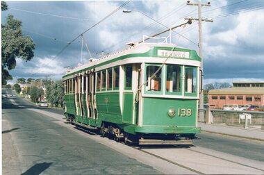
Photograph - Set of two Colour Prints, Jeff Bounds, 27/07/1991 12:00:00 AM
Colour print of Bendigo Tram 24 dressed as its Melbourne number 138 (P class) operating a tour 27/7/1991 operated by Jeff Bounds, in Nolan St. Bendigo. .1 - In Nolan St at the creek bride. .2 - In Bridge St at Nolan St Corner.In ink on the back of each print: "Bendigo, Tram tour run by Jeff Bounds on Sat 27/7/91 before 138 (ex Bendigo 24) was exchanged to Melbourne for SW5 808."trams, tramways, bendigo, nolan st, tours, p class, tram 138, tram 24 -
 Clunes Museum
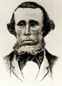
Photograph, JAMES ESMOND
JAMES ESMOND REPORTED GOLD DISCOVED IN 1851 ON THE PROPERTY OF DONALD CAMERON WHO PERSUADEDHIM TO KEEP THE DISCOVERY A SECRET..1 COPY OF A BLACK AND WHITE PHOTOGRAPH OF JAMES ESMOND .2 COPY OF A BLACK AND WHITE PHOTOGRAPH OF JAMES ESMONDPRINTED ON BOTH COPIES ON TOP: WHICH HE FOUND IN THE RANGES ON THE [CLUNES] RUN. DONALD CAMERON PERSUADED HIM [TO KEEP TH] E DISCOVERY SECRET. (PORTION OF TEXT CUT OFF)local history, photographs, james esmond -
 Creswick Campus Historical Collection - University of Melbourne
Still Image, 1962
Subject: Kuark- McKenzie Crk Project . 5 brown envelopes marked Run 1A - Run 5 of 10 prints each. Stored in a brown cardboard file box marked Kuark- McKenzie Crk Project. Photos commissioned by Forests Commission Victoria 1962.Aerial Photographs -
 Kiewa Valley Historical Society
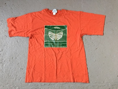
T-Shirt - Mt Beauty Festival of Bogong Moths
See KVHS 1481 Run by the Chamber of Commerce in November in 1994 and 1995Held in 1994 and 1995 in the Kiewa Valley in recognition of the aboriginal people who lived and gathered in the Kiewa Valley.Orange T-shirt with a iron-on green square which has white print on it. The print includes that of a moth.White print: "Mt Beauty / Festival of the Bogong Moth"bogong moth festival, mt beauty chamber of commerce, aboriginal -
 Uniting Church Archives - Synod of Victoria
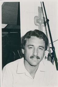
Photograph, Ray Comfort, 1987
Evangelist Ray Comfort was part of a crusade run by the Melton Uniting ChurchB & W photograph of evangelist Ray Comfort. Name and C&N details.ray comfort, melton uniting church -
 Maryborough Midlands Historical Society operating the Worsley Cottage Museum
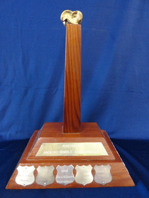
Trophy, c. 1984
The "Jack Be Nimble" competition was run as part of Maryborough's annual Wattle Festival.The competition for which the trophy was presented is based on the traditional game of knucklebones or "Jack - Be - Nimble". The now defunct Wattle Festival was a significant feature of the town's cultural life for many years. Varnished wood two- layer base with central pillar, topped with gold coloured knucklebone. Metal plaque on upper layer of base and metal shields on lower level.Jack Be Nimble competition (main plaque) Individual competition winners noted on shields (Betty Briggs (1984), Isa Stewart (1985), Frank O'Connor (1986, 1987, 1988, 1989), Susan Crouch (1990), Vicki-Lee Rush (1992/3).trophy festival -
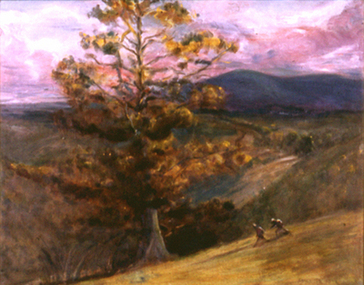 Nillumbik Shire Council
Painting: Sonia Skipper (b.1918 WA - d.2008 Renmark, SA), After the Fire, 1962
Landscape painting of a pine in the Australian bush landscape. Painted just after the devastating Victorian bushfires of 1962. Two figures run down the hill in the foreground. There are hills in the background and the sky is shades of pink and violet. Painted in warm earth tones in a painterly, tonal realist style.Lower right, grey paint, signature: 'Sonia Skipper' -
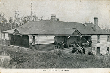 Mt Dandenong & District Historical Society Inc.
Photograph, The Hospice, Olinda, early 1900s
Postcard photograph of The Hospice Guest House at Olinda. The Hospice was built by Joseph Gutmann in 1904 and run by the Dorey family from 1908 - 1911. The Hospice catered for up to 60 guests.The Hospice was in the Main Street of Olinda. It burned down in 1924. This photograph would be early 1900s.the hospice, guest house, guesthouse, joseph gutmann, dorey, olinda -
 Bendigo Historical Society Inc.
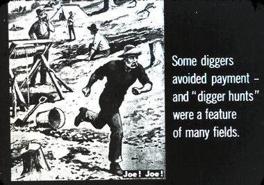
Slide - DIGGERS & MINING. THE GOLD LICENCE, c1850s
Diggers & Mining. The gold licence. The Government Camp. Depicts diggers on the goldfield with one on the run. Some diggers avoided payment - and ''digger hunts'' were a feature of many fields. 'Joe! Joe!' marked on picture. Markings: 32 994.LIF. 4. Used as a teaching aid.hanimounteducation, tertiary, goldfields -
 Bendigo Historical Society Inc.
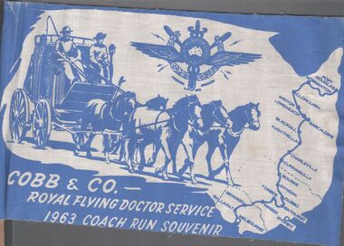
Ephemera - Aileen and John Ellison Collection: Cobb & Co.flag
RFDS was begun by Reverend John Flynn as an aerial Medical Service out of Cloncurry, Queensland in 1928. By 1934 it had expanded across outback Australia. Cobb and Co. was a stagecoach line transporting diggers between the gold fields. There were many coach lines but there names were generalised to "Cobb and Co. It operated between 1853 and 1924.Two small blue and white flag for Cobb & Co. - Royal flying Doctor service 1963 coach run souvenir. The flag has a map of Australia, a horse drawn coach with two men driving, the emblem of the flying doctors and the route from Melbourne to Port Douglas.cobb & co., flying doctors, coach run -
 City of Kingston
Photograph - Black and white, c.1973
A photograph showing the interior of a libraryBlack and white photograph of a library interior. A display shelf faces outward, with a table and chairs at the left hand end adjacent to a pillar. A notice advertising Storytime sits atop the display shelf. Further shelves run along the left hand wall under large windows. library, libraries -
 Lakes Entrance Historical Society
Photograph - Fun Run, Lakes Post Newspaper, 1993
Black and white photograph trophy winners Peta Maher, Corina Cross, Jean Crawford, Peter Field, Doug Anderson, Alan Postlethwaite, Shannon Salisbury, Dean Crosbie, Kate Anderson, Kylie Graeme, Kaye Andrew, after Fun Run Lakes Entrance Victoriasports, recreation -
 Ballarat Tramway Museum
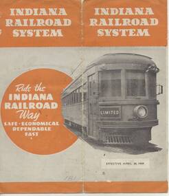
Ephemera - Timetable, Indiana Railroad, "Indiana Railroad system, Timetable, April 30, 1939" - Wal Jack Collection, Apr. 1932
Eight page (folded) timetable for the Indiana Railroad (Interurban Traction Co.) in receivership at time (see page 2), map of page 1, showing routes and connecting lines, bus services, services, days run etc. Record images added 20/8/2013.On each timetable in pencil, whether traction operated or bus (coach), where coach, crossed out in pencil.indiana railroad (electric cars), indianapolis, terre haute, timetables -
 Greensborough Historical Society
Slide - Photograph, John Ramsdale, Headwaters of the Plenty River: Slide 81, 1990s
Photograph shows hill with trees and run off to the river. This is the headwaters of the Plenty River.Part of the John Ramsdale collection of slides and audio visual material.Colour photograph scanned from slide.No maker's marks. No caption on slide.plenty river -
 Lake Bolac & District Historical Society
Black and white photograph, Woolshed and outbuildings of "Wynawang", Wickliffe
Woolshed, Stables and machinery shed of "Wynawang", Wickliffe. Owned and run by the Howlett family.wickliffe, "wynawang", howlett, woolshed, stables, machinery shed. -
Creswick Campus Historical Collection - University of Melbourne
Ephemera - Photographs and documents relating to the Creswick Family Holidays on Campus, 1990s
Photographs and documents relating to the Creswick Family Holidays run at the Campus in the early 1990sPhotographs -
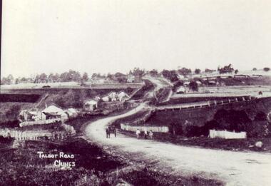 Clunes Museum
photograph
OWNED AND RUN BY JOHAN CONRAD WEICKHARDT UNTIL 1905. BUILDING NO LONGER IN EXISTENCE.AN EARLY PHOTOGRAPH COPY OF TALBOT ROAD CLUNES. BRITISH HOTEL, FIRST BUILDING ON LEFT.local history, photography, photographs, clunes landscape -
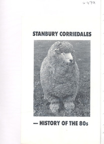 National Wool Museum
Pamphlet, Stanbury Corriedales - history of the 80s
"Stanbury Corriedales" - history of the 80s at the Stanbuy Corriedale Stud, run by the Wettenhall family.corriedale sheep sheep breeding, australian corriedale association, pettitt, mr r. w., stanbury corriedale stud, victoria, corriedale sheep, sheep breeding -
Creswick Campus Historical Collection - University of Melbourne
Still Image, 1964
Subject: Lower Glenelg Plantation . 7 brown envelopes marked Run 1. No. 12 - 17of 9 prints each. Stored in a brown cardboard file box marked Lower Glenelg Plantation Run No.1. 11 - 17(x9). Photos commissioned by Forests Commission Victoria 1964.Aerial Photographs -
 City of Kingston
Photograph - Black and white, 20 December 1945
Cheltenham is a suburb in the City of Kingston that was originally established as a rural market gardening community. The area is bordered by Highett, Mentone and Heatherton. The market gardens, farms and paddocks have gradually been sub-divided into housing and industrial estates. The Southland shopping centre is a major feature of the area.Cheltenham was established as a rural market gardening community. The Le Page family lived in Cheltenham since 1854 when Nicholas Le Page, a tailor from the Channel Island of Guernsey, bought two acres of land on Chesterville Road near Bernard Street to establish a market garden. Over the years the Le Pages purchased more land in the area. In 1875-76 Nicholas' son Frank and his wife Mary built 'Daphne Cottage' near the corner of Bernard and Wilson Streets. n the 1940s Frank's son, Everest Le Page, bought five more lots of land in Chesterville Road from the Tuck family. The Le Pages grazed horses, ponies and cows on this land, and grew pumpkins, carrots, parsnips, onions, potatoes and cabbages. Many buildings and locations within in Cheltenham commemorate the Le Page family's contribution to the Cheltenham community.Aerial photograph taken in 1945 of the Cheltenham district within the City of Kingston. The image includes Chesterville Road, the future site of Turner Road pool (now Waves) and Highett Reserve, (top left), Jellicoe Street, Argus Street, Bernard Street, Wilson Street, the Methodist Children Homes (now Southland), McIvor Street, Goulburn Street, Nepean Highway, Jamieson Street and Barker Street (bottom left), market gardens and paddocks. In the top centre of the image, "Daphne Cottage", the home of Frank T. Le Page is visible on the corner of Bernard and Wilson Streets. Much of the land depicted in this image was owned by the Le Page family. This image is possibly from the collection of aerial photographs commissioned by the Department of Crown Lands and Survey and taken by Adastra Airways.Black and white ink: 57250 White print: VIC-170 57250 20.12.45 Run 6 PROJ. No. 5 MELB. METROP AREA Black type 10200 FTS 30' LENS 20.12.45cheltenham, market gardens, industry, le page family -
City of Kingston
Photograph - Black and white, 5 January 1984
Cheltenham and Heatherton are suburbs in the City of Kingston that were originally established as a rural market gardening community. The market gardens, farms and paddocks have gradually been sub-divided into housing and industrial estates and associated infrastructure such as schools and shopping facilities. This aerial image covers a diverse section of the City of Kingston, taking in the suburbs of Cheltenham, Heatherton, Mentone and Parkdale. By 1984, the market gardens of the district have been replaced by housing and factories. The Nylex factory is visible and now closed. Mentone Bowl on the corner of Warrigal Road and Nepean Highway has now been replaced by high rise apartments, another feature of the changing landscape in the City of Kingston. The vacant land now occupied by the Moorabbin Airport Direct factory Outlet (DFO) is also depicted.Aerial photograph of Cheltenham, Heatherton, Mentone and Parkdale within the City of Kingston. The area depicted in the 1984 aerial view includes Centre Dandenong Road and Cheltenham East Primary School (top left), Kingston Heath Reserve (top right), intersection of Lower Dandenong Road, Warrigal Road, Balcombe Road and Nepean Highway (bottom left), Balmoral Drive/McSwain Street Parkdale (bottom right).White text: 3831-179 Lens information [indecipherable] RINGWOOD M/S 7922-3 RUN 16 [Clockface image] 5,300' ASL VIC DLS© 5-1-84cheltenham, heatherton, mentone, parkdale, market gardens, urbanisation -
City of Kingston
Photograph - Black and white, 5 January 1984
Moorabbin, Cheltenham and Highett are suburbs in the City of Kingston with a diverse mix of development and zoning. The market gardens, farms and paddocks have gradually been sub-divided into housing and industrial estates and associated infrastructure such as schools and shopping facilities. The area includes many parks, reserves and golf courses.This aerial image covers a diverse section of the City of Kingston, taking in the suburbs of Cheltenham, Moorabbin, Beaumaris and Highett. By 1984, the market gardens of the district have been replaced by housing and factories. The Gas and Fuel state-of-the-art Scientific Services Department is visible on Nepean Highway Highett. The CSIRO Highett site can also be seen. Both sites have now been demolished and have undergone remediation. The Southland site is visible and yet to be redeveloped by Westfield. This image portrays the diversity of development in the City of Kingston with a mixture of green spaces, housing and commercial and industrial features.Aerial photograph of Cheltenham, Beaumaris, Moorabbin and Highett within the City of Kingston. The area depicted in the 1984 aerial view includes Eden Street and Edward Street, Cheltenham (top left), Weatherall Road and Reserve Road, Cheltenham/Beaumaris (top right), Turner Road and Chesterville Road, Moorabbin (bottom left), Nepean Highway (left section), Graham Road and Middleton Street, Highett (bottom right). A large section of this image includes Cheltenham Park and Victoria Golf Club.White text: 3831-219 Lens information [indecipherable] RINGWOOD M/S 7922-3 RUN 15 Clockface image 5,300' ASL VIC DLS© 5-1-84cheltenham, highett, industrialisation, urbanisation, moorabbin, beaumaris -
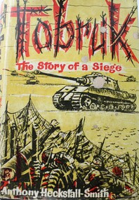 Wodonga & District Historical Society Inc
Book - Tobruk - The story of a Siege, Anthony Heckstall-Smith, 1959
The Siege of Tobruk lasted for 241 days in 1941. Tobruk was the only harbour between Bengazi and Alexandria and became crucial in preventing Rommel's sweep to the Nile. Tobruk was captured in 1941 and became a beleagured fortress until its garrison was relieved in November 1941. Churchill and his War Cabinet had declared that "Tobruk must be held to the death". The Australians under Major General Morshead fought like tigers . Nazi propaganda radio broadcasts spoke contemptuously of the Tobruk defenders as ‘rats’. In defiance, the soldiers proudly adopted this nickname and have been known by it ever since. During the siege, they designed their own medals, in the shape of a rat, made from the scrap metal of a downed German aeroplane. Anthony Heckstalk-Smith who was himself a Flotilla Officer the "A" Lighters which provided supplies to the garrison, researched evidence from officers of all units involved - Australian, South African, German and British to write this controversial story of men in battle.non-fictionThe Siege of Tobruk lasted for 241 days in 1941. Tobruk was the only harbour between Bengazi and Alexandria and became crucial in preventing Rommel's sweep to the Nile. Tobruk was captured in 1941 and became a beleagured fortress until its garrison was relieved in November 1941. Churchill and his War Cabinet had declared that "Tobruk must be held to the death". The Australians under Major General Morshead fought like tigers . Nazi propaganda radio broadcasts spoke contemptuously of the Tobruk defenders as ‘rats’. In defiance, the soldiers proudly adopted this nickname and have been known by it ever since. During the siege, they designed their own medals, in the shape of a rat, made from the scrap metal of a downed German aeroplane. Anthony Heckstalk-Smith who was himself a Flotilla Officer the "A" Lighters which provided supplies to the garrison, researched evidence from officers of all units involved - Australian, South African, German and British to write this controversial story of men in battle.world war 11, rats of tobruk, tobruk, siege of tobruk, arthur lock -
 Kiewa Valley Historical Society
Chart: Bogong High Plains Cattle Allocation
Includes the names of farmers in the Kiewa ValleySoil Conservation Authority, Bogong High Plains, Cattle Allocation Marking/Brand Identifications Season 1958/59. Drawn 7-1-59, DWG No 679 file Sc/D/4M Chart gives details of Names, Run No., Earmarks, Brand & Location & Breed of cattle.Penciled in details under 'Name' 1978/Roper/W.Ryder/F.Ryder/W.Hicks/Maddison.chart, cattle, markings, brandings, bogong high plains, roper, ryder, hicks, maddison -
 Bendigo Military Museum
Instrument - BUGLE WW1, Mathias Road, 1914
WWI Army Bugle has Australian Commonwealth Military Force Rising Sun Badge with a copper letter A fixed beside the Rising Run. Main body is made out of copper, the muzzle & breech are brass. The rear arve has a brass outer plate. The lip nozzle is missing.“Mathias Rd London N. 1914” Some non sensical letters scratched onto brass muzzle.musical instruments - wind, metalcraft - copper - brassware, military history, bugle -
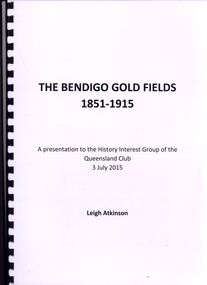 Bendigo Historical Society Inc.
Book - THE BENDIGO GOLDFIELDS 1851-1915, 3 july 2015
The Bendigo Gold Fields 1851-1915 a presentation to the history interest group of Queensland Club 3 July 2015 by Leigh Atkinson 12 pages in a spring bound binder contains black and white and colour photographs with info on Vahland, Lansell, Harry Leigh Atkinson & Ravenswood Run.Leigh Atkinsonbook, bendigo, bendigo history & its people -
Port Melbourne Historical & Preservation Society
Plan, J W Banks, Plans and Sections of Tramsway, Apr 1889
Large book of 9 pages, incl. title page, bound on left with black tape, wih plans and typeset descriptions of a proposal to run a cable tram under the Yarra from Williamstown to Melbourne (Falls Bridge) via Port Melbourne. Submitted to Victorian Legislative Assembly 1889Signed p. 2 by J.W. Banks, C.E.transport - tramways, town planning - proposals shelved, williamstown, j w banks