Showing 19357 items matching "shipwreck-coast"
-
 Robin Boyd Foundation
Slide, Robin Boyd, 1971
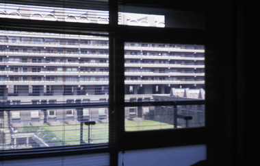
In April-May 1971, Robin and Patricia Boyd travelled to Honolulu, east coast USA and London. In London he was one of the judges for the Commonwealth-wide entries for the redevelopment of Whitehall and the Palace of Westminster. He was also researching overseas libraries, as background for plans for a new State Library of Victoria.Colour slide in a mount. Barbican Centre, London, England, 1965-76. (Architects: Chamberlin Powell & Bon.)Inscribed Made in Australia / 26 / AUG 71M1slide, robin boyd -
 Robin Boyd Foundation
Slide, Robin Boyd, 1971
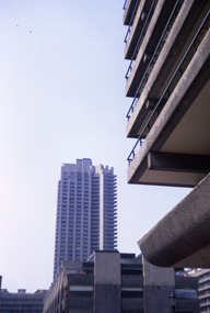
In April-May 1971, Robin and Patricia Boyd travelled to Honolulu, east coast USA and London. In London he was one of the judges for the Commonwealth-wide entries for the redevelopment of Whitehall and the Palace of Westminster. He was also researching overseas libraries, as background for plans for a new State Library of Victoria.Colour slide in a mount. Roman House on right, Barbican Centre, London, England, 1965-76. (Architects: Chamberlin Powell & Bon.)Inscribed Made in Australia / 22 / AUG 71M1slide, robin boyd -
 Robin Boyd Foundation
Slide, Robin Boyd, 1971
In April-May 1971, Robin and Patricia Boyd travelled to Honolulu, east coast USA and London. In London he was one of the judges for the Commonwealth-wide entries for the redevelopment of Whitehall and the Palace of Westminster. He was also researching overseas libraries, as background for plans for a new State Library of Victoria.Colour slide in a mount. Barbican Centre, London, England, 1965-76. (Architects: Chamberlin Powell & Bon.)Inscribed Made in Australia / 24 / AUG 71M1slide, robin boyd -
 Robin Boyd Foundation
Slide, Robin Boyd, 1971
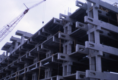
In April-May 1971, Robin and Patricia Boyd travelled to Honolulu, east coast USA and London. In London he was one of the judges for the Commonwealth-wide entries for the redevelopment of Whitehall and the Palace of Westminster. He was also researching overseas libraries, as background for plans for a new State Library of Victoria.Colour slide in a mount. Building under construction, unknown location (NYC, London or Hawaii) (see also S1162)Inscribed Made in Australia / 12 / AUG 71M1slide, robin boyd -
 Robin Boyd Foundation
Slide, Robin Boyd, 1971
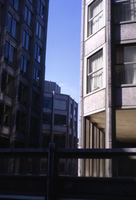
In April-May 1971, Robin and Patricia Boyd travelled to Honolulu, east coast USA and London. In London he was one of the judges for the Commonwealth-wide entries for the redevelopment of Whitehall and the Palace of Westminster. He was also researching overseas libraries, as background for plans for a new State Library of Victoria.Colour slide in a mount. The Economist Buildings (three of them: 15, 8 and 5 stories), Smithson Plaza, London, England, 1964. (Architects: Alison and Peter Smithson.)Made in Australia / 20 / AUG 71M1 robin boyd, slide -
 Lara RSL Sub Branch
Photograph, Australian infantry in New Guinea 1939/45 war
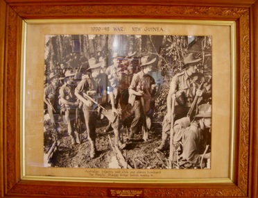
The Battle of the Shaggy Ridge was part of the Markham and Ramu Valley – Finisterre Range campaign, consisting of a number of actions fought by Australian and Japanese troops in Papua New Guinea in World War II. Following the Allied capture of Lae and Nadzab, the Australian 9th Division had been committed to a quick follow up action on the Huon Peninsula in an effort to cut off the withdrawing Japanese. Once the situation on the Huon Peninsula stabilised in late 1943, the 7th Division had pushed into the Markham and Ramu Valleys towards the Finisterre Range with a view to pushing north towards the coast around Bogadjim, where they would meet up with Allied forces advancing around the coast from the Huon Peninsula, before advancing towards Madang.In late December 1943, the Australian offensive to take Shaggy Ridge began, focused on an attack on The Pimple.[13] The Pimple was one of three rocky outcrops, held by the Japanese on the ridge line.Framed Photograph of Australian infantry waiting while our planes" bombard the Pimple,"Shaggy Ridge before moving in. Australian infantry waiting while our planes" bombard the Pimple,"Shaggy Ridge before moving in. THE LARA BRANCH R.S.S.I.L.A. FROM MRS HAMILTON CALVERT =MEMORIES=ww2, papua new guinea, world war 2, lara r.s.l., photographs, australian infantry, shaggy ridge -
 Flagstaff Hill Maritime Museum and Village
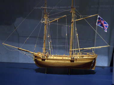
Craft - Ship Model, H.M.S. Lady Nelson, 1988
This model of the ship H.M.S. Lady Nelson was researched and built as the vessel Lady Nelson by David Lumsden, a professional ship model builder. His Majesty's Armed Survey Vessel Lady Nelson was commissioned in 1799 to survey the coast of Australia. This vessel was purpose-built before the British Admiralty requested plans for a Schooner for Port Jackson. At the time large parts of the Australian coast were unmapped and Britain had claimed only part of the continent. The British Government were concerned that, in the event of settlers of another European power becoming established in Australia, any future conflict in Europe would lead to a widening of the conflict into the southern hemisphere to the detriment of the trade that Britain sought to develop. Against this background, Lady Nelson was chosen to survey and establish sovereignty over strategic parts of the continent. Lady Nelson left Portsmouth on 18 March 1800 and arrived at Sydney on 16th December 1800 after having been the first vessel to reach the east coast of Australia via the Bass Strait. Before that date, all vessels had sailed around the southern tip of Tasmania to reach their destination. Lady Nelson's survey work commenced shortly after she arrived in Sydney, initially in the Bass Strait area. She was involved in the discovery of Port Phillip, on the coast of Victoria, in establishing settlements on the River Derwent and at Port Dalrymple in Tasmania. She also successfully chartered much of the Victorian coastline and was heavily involved with the exploration of the Queensland coast with Matthew Flinders; investigated the Hunter River; made numerous visits to New Zealand and Norfolk Island and was involved in the founding of numerous settlements. In comparison to most colonial vessels, the Lady Nelson was technically unique she was fitted with sliding keels, or centreboards, and water-tight trunks reaching to the deck. Captain Schank invented these sliding keels that, when raised, reduced her draught to less than six feet. Her life as an exploration vessel ended while accompanying HMS 'Tamar' to Melville Island in 1825, the 'Lady Nelson' was captured and later abandoned by pirates off the island of Babar (Indonesia). This brought the vessel's 25 years of coastal exploration and navigation to a close.The Lady Nelson made was the first British ship to survey of the southern or south-western coast of Australia and traverse the Bass Strait. The vessel holds a special place in Australia's history of exploration as the first to explore and establish settlements in the then-new British colony of Van Diemans Land. The model gives an insight into what life must have been like onboard sailing vessels of the time and Australia's early history of establishment and exploration. This model acts as an important legacy of the full-scale ship which no longer survives. Ship model of the 60 ton British brig HMS Lady Nelson. Timber model of a two-masted brig with rigging but no sails, displaying the British Union Jack flag. The ship is in a glass exhibition display case on metal stand. HMS Lady Nelsonflagstaff hill, warrnambool, shipwrecked coast, flagstaff hill maritime museum, maritime museum, shipwreck coast, flagstaff hill maritime village, great ocean road, by captain john schanck, sliding keels or centreboards, lady nelson, british brig hms lady nelson, david lumsden ship model builder, lieutennant james grant, bass strait discovery, surveying king island and port phillip bay, philip gidley king -
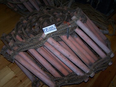
 Parks Victoria - Port Campbell Rocket Shed
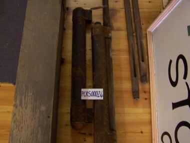
Rocket gear
Rocket equipment which has been used in various lifeboat and rocket stations on the Victorian Coast. It is unclear if this is the original rocket equipment from Port Campbell. This equipment, if not original has been used in rescue operations and is identical to the equipment that was in use at Port Campbell from C.1890 onwardsTwo cylindrical rockets made of base metal with orange painted wooden heads. Three long cedar, wooden sticks (octaganal) that attach to the rockets. They have spring clips and a section of metal and a sheath to protect the wood from fire and with grooves for the rope. One rocket is attached firmly to a stick. A long length of cotton/linen (?) rope is attached to one of the rocketsYes -
 Parks Victoria - Port Campbell Rocket Shed
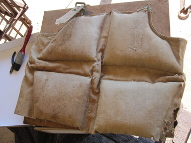
Life jackets
This rocket equipment has been used in various lifeboat and rocket stations on Victorian Coast. It is unclear if this is the original rocket equipment from Port Campbell. This equipment, if not original to the site, has been used in rescue operations and is identical to the equipment that was in use at Port Campbell from C.1890 onwardsTwo canvas lifejackets, one is filled with cotton or silk and the other with cork. The jackets are sewn in sections that hold either the cork or the cotton/silk. One of the lifejackets has a separate strap and brass eyelets and buckles. -
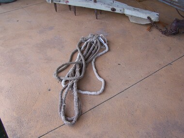
 Parks Victoria - Port Campbell Rocket Shed
Rope ladders
This rocket equipment has been used in various lifeboat and rocket stations on Victorian Coast. It is unclear if this is the original rocket equipment from Port Campbell. This equipment, if not original to the site, has been used in rescue operations and is identical to the equipment that was in use at Port Campbell from C.1890 onwardsTwo rope ladders, identical in format and length. The rungs are made from another type of material. -
 Parks Victoria - Port Campbell Rocket Shed
Rope strops
This rocket equipment has been used in various lifeboat and rocket stations on Victorian Coast. It is unclear if this is the original rocket equipment from Port Campbell. This equipment, if not original to the site, has been used in rescue operations and is identical to the equipment that was in use at Port Campbell from C.1890 onwardsFour rope strops, three are of equal length. Lengths of rope spliced or joined to form a circle of approx. 100cm diameter. The long rope is triple laid rope and the three shorter ropes are made of multiple small strings (approx.40) bound together. Use is yet to be determined. -
 Parks Victoria - Port Campbell Rocket Shed
Rocket line
This rocket equipment has been used in various lifeboat and rocket stations on Victorian Coast. It is unclear if this is the original rocket equipment from Port Campbell. This equipment, if not original to the site, has been used in rescue operations and is identical to the equipment that was in use at Port Campbell from C.1890 onwardsRope handled timber box with faking pins. The Rocket Line was attached to the rocket and fired over the ship in distress. The light rocket line, was folded in such a way that it paid out easily as the rocket shot through the air. -
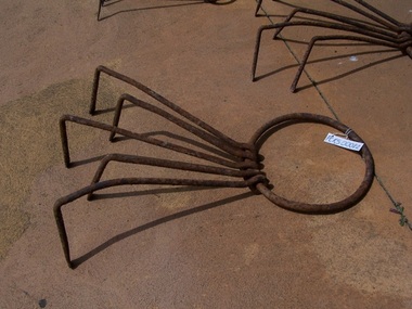 Parks Victoria - Port Campbell Rocket Shed
Anchors
This rocket equipment has been used in various lifeboat and rocket stations on Victorian Coast. It is unclear if this is the original rocket equipment from Port Campbell. This equipment, if not original to the site, has been used in rescue operations and is identical to the equipment that was in use at Port Campbell from C.1890 onwardsEach of the five anchors have an iron ring (2 large, 1 medium, 2 small) to which are attached 5 iron hooks. Medium has 4 hooks.Each has an iron ring 2 large, 2 small to which is attached iron hooks. -
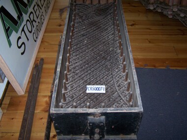
 Parks Victoria - Port Campbell Rocket Shed
Stretcher
This rocket equipment has been used in various lifeboat and rocket stations on Victorian Coast. It is unclear if this is the original rocket equipment from Port Campbell. This equipment, if not original to the site, has been used in rescue operations and is identical to the equipment that was in use at Port Campbell from C.1890 onwardsBody of rescue stretcher is canvas and timber slats. Straps of canvas webbing attached to sides. Rope loops at either end, rope runs along the length of stretcher. Opens out to secure patient. -
 Parks Victoria - Port Campbell Rocket Shed
Anchor pegs
This rocket equipment has been used in various lifeboat and rocket stations on Victorian Coast. It is unclear if this is the original rocket equipment from Port Campbell. This equipment, if not original to the site, has been used in rescue operations and is identical to the equipment that was in use at Port Campbell from C.1890 onwardsEach of the six iron pegs has a spike on one end and eyelet on the other. -
 Parks Victoria - Port Campbell Rocket Shed
Rope
This rocket equipment has been used in various lifeboat and rocket stations on Victorian Coast. It is unclear if this is the original rocket equipment from Port Campbell. This equipment, if not original to the site, has been used in rescue operations and is identical to the equipment that was in use at Port Campbell from C.1890 onwardsRope, 1cm light line -
 Parks Victoria - Port Campbell Rocket Shed
Box
This rocket equipment has been used in various lifeboat and rocket stations on Victorian Coast. It is unclear if this is the original rocket equipment from Port Campbell. This equipment, if not original to the site, has been used in rescue operations and is identical to the equipment that was in use at Port Campbell from C.1890 onwardsRectangular box with fitted lid. All wood. Two rope handles at each end. Inscribed on lid -"Lights Illuminating Wrecks. Mark-IV 3 . 4/7/1910"Inscribed on lid -"Lights Illuminating Wrecks. Mark-IV 3 . 4/7/1910" -
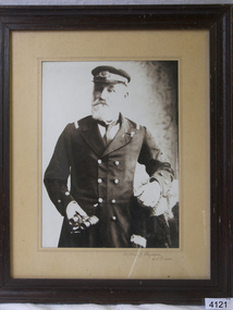 Flagstaff Hill Maritime Museum and Village
Photograph - Captain F Chapman SS Dawn
... shipwreck-coast ...The Dawn steamship was a 522-ton coastal trader built in 1876 and it’s original captain Jones operated the vessel around the Victorian west coast from 1877 until 1898 for the Portland & Belfast Steam Navigation Co, the vessel was then owned in October 1885 by the renamed company, Belfast & Koroit Steam Navigation Co., until March 1896 when it’s ownership moved to W Howard Smith & Sons Ltd., This Melbourne company used the ship to service most ports around Australia. Captain F Chapman took over from captain Jones and served on the SS Dawn from 1898 until 1900 when he took command of the SS Casino operated by the Belfast & Koroit Shipping Company at Port Fairy and became the captain from 1900 until 1922 when he retired after twenty-two years becoming the ships longest-serving captain. Captain Roberts took over command until 1924 followed by captain Middleton until 1932 when the Casino was sunk off Apollo Bay and captain Middleton collapsed and died in the surf. Picture of a long serving sea captain connected with a significant ship that was involved in a significant historical incident prior to his taking command of the vessel also his long time association with Port Fairy's Belfast Steam Navigation Company until 1922.Photograph of Captain Chapman framedCaptain F Chapman SS Dawnflagstaff hill, warrnambool, shipwrecked-coast, flagstaff-hill, flagstaff-hill-maritime-museum, maritime-museum, shipwreck-coast, flagstaff-hill-maritime-village, photograph, captain chapman, ss dawn -
 Flagstaff Hill Maritime Museum and Village
Decorative object - Wallpaper sample, c. 1870s to early 1900s
This wallpaper section is from the original Warrnambool Lighthouse Keeper's Quarters built in the late 1850s on Middle Island, and the building was moved to Flagstaff Hill in 1871-72. The wallpaper was salvaged from Assistant Keeper's residence (Shipwreck Museum) during heritage works in 2023, to upgrade the ageing exhibition space in the historic building.The wallpaper section is significant for its association with the Warrnambool Lighthouse Keeper's Quarters from the late 19th to early 20th centuries. It is also significant as an example of the paper, method of displaying and pattern on the paper, an indication of the materials and patterns available to decorate homes in those times.Wallpaper sample, irregular shape. Wallpaper has been recovered from behind a 1970s built feature in the Warrnambool Lighthouse Keeper's Residence, Assistant's Quarters. The light-coloured textured paper has a small cream-coloured embossed pattern. The sample has two layers of thickness and the back layer is two overlapping pieces. There are holes along the edge where the paper was fixed to another surface.flagstaff hill, warrnambool, maritime museum, shipwreck coast, warrnambool lighthouse keeper's quarters, wall paper, domestic furnishings, wall covering, domestic soft furnishing, wall decoration, wallpaper section, wallpaper, late 19th century wallpaper -
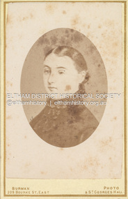 Eltham District Historical Society Inc
Photograph, W.J. Burman, Eva Carmichael, sole surviving passenger of the wreck of the Loch Ard, 1878
Special Carte-de-Visite produced by W. Burman, July 3,1878 featuring the sole surviving passenger of the wreck of the ship, Loch Ard near Mutton Bird Island on the Shipwreck Coast of Victoria on June 1st, 1878. THE PHOTOGRAPHIC SOCIETY. (1878, October 12). The Age (Melbourne, Vic. : 1854 - 1954), p. 7. Retrieved December 4, 2022, from http://nla.gov.au/nla.news-article199353573 According to Sands & McDougall Melbourne Directory, Burman's were operating from 209 Bourke St. East and St George's Hall (73 Bourke St. East) from 1879-1885 Back of photo is overtsamped "Registered Copyright by W. Burman, July 3rd 1878" CARTE-DE-VISITE (cdv) 1857-1890 Cartes-de-visite (cdv's) are the most common form of photograph from the nineteenth century, generally measuring two and a half inches by four and an eighth inches (6.3 x 10.5 cm) when mounted, sepia toned, mounted on a card which was generally printed with the photographer's name and address on the back or beneath the portrait. - Frost, Lenore; Dating Family Photos 1850-1920; Valiant Press Pty. Ltd., Berwick, Victoria 1991marg ball collection, 1878, 1878-1885, burman's photographer 209 bourke st east and st georges hall melbourne, shillinglaw family photo album 2, eva carmichael, loch ard (ship) -
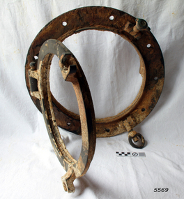 Flagstaff Hill Maritime Museum and Village
Functional object - Porthole frame, ca. 1889
This porthole and porthole cover was removed from the stern of the Newfield wreck, on the starboard side. The barque Newfield left Liverpool on 1st June 1892 with a cargo of 1850 tons of fine rock salt for Brisbane. About six weeks later the ship ran into very heavy weather approaching the Australian coast. On 28th August at about 9pm her master, Captain George Scott, observed between the heavy squalls the Cape Otway light on the mainland of Victoria, but due apparently to a navigational error (the chronometers were incorrect), he mistook it for Cape Wickham on King Island, some 40 miles south. He altered course to the north expecting to run through the western entrance of Bass Strait, but instead, at about 1:30am, the ship ran aground about about 100 yards from shore, one mile east of Curdies River. The vessel struck heavily three times before grounding on an inner shoal with six feet of water in the holds. The Newfield remained upright on the reef with sails set for a considerable time as the wind slowly ripped the canvas to shreds and the sea battered the hull to pieces. Seventeen men survived the shipwreck but the captain and eight of his crew perished.Flagstaff Hill’s collection of artefacts from the Newfield is significant for its association with the shipwreck Newfield, which is listed on the Victorian Heritage Registry. The collection is significant because of the relationship between the objects. The Newfield collection is archaeologically significant as the remains of an international cargo ship. The Newfield collection is historically significant for representing aspects of Victoria’s shipping history and its association with the shipwreckPorthole frame, including porthole and porthole cover, from the wreck of the Newfield. Porthole secured by nine bolts. It was removed from the stern of the wreck on the starboard side. there is some marine growth on the porthole. The cover still opens. warrnambool, shipwrecked coast, flagstaff hill, flagstaff hill maritime museum, maritime museum, shipwreck coast, flagstaff hill maritime village, shipwrecked artefact, 1892, 1893, 28 august 1892, 29 august 1892, barque, curdie's river, newfield, nineteenth century, peter ronald, peterborough, port campbell, porthole, porthole cover, shipwrecks, victorian shipwrecks, porthole frame -
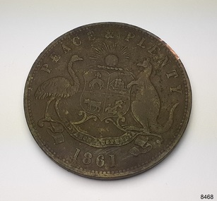 Flagstaff Hill Maritime Museum and Village
Currency - Coin, Robert Hyde & Co. Shipping Merchants, 1861
The donor (a local resident.) of this coin found this penny token coin in the sand dunes of Lady Bay, Warrnambool, in 2023. The coin could have come from a local shipwreck, passengers, or members of the community. Trade was carried out along the southwest coast of Victoria between Melbourne and Portland, with the Port of Warrnambool receiving passengers and goods by coastal traders, the steamboat that set off from ports every few days. One such vessel was the steamship SS Edina that made her first voyage from Melbourne to Portland in 1863. For around a decade or so in the Gold Rush period in Australia there was a shortage of official government currency. It was acceptable during this time to use token coins minted by local businesses to be used within their store, much like the loyalty and rewards cards that businesses give their customers in modern times. The tokens were also a good way to advertise their wares and details. The first token was introduced in Melbourne in 1848 and were used until 1868, when they became illegal in New South Wales. They were minted in Australia and overseas. The token was issued by Robert Hyde & Co. who traded in second-hand goods such as old clothes, sheets, metal items and glass, which they resold to be re-manufactured, or "recycled".A token such as this one identifies businesses existing in the post-Gold Rush period in Australia. Round copper coin. Penny token coin bearing the Australian Coat of Arms and motto. The coin also has the company's name, location, nature of business and motto. The coin has grooves around the edge. It was made in 1861.OBVERSE: Logo: (Australian Coat of Arms), Motto: "PEACE & PLENTY", Date: 1861 REVERSE: "ROBERT HYDE & CO MELBOURNE", "GENERAL MARINE STORE, SHIPPERS OF RAGS GLASS METALS &.C"flagstaff hill maritime museum and village, warrnambool, great ocean road, shipwreck coast, merchant token, melbourne, token, australian token, trade token, coins, merchants, medal, colonisation, gold rush, robert hyde & co., general marine store, shippers of rags glass metals etc., numismatics, second-hand scrap, scrap goods -
 Wangaratta RSL Sub Branch
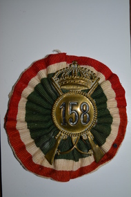
Badge - Hat Badge, Italian
Brass hat badges of the 158th Infantry Division Zara a regular infantry division of the Royal Italian Army and a garrison unit stationed on the Dalmation Coast during WW2. It surrendered to the Germans after the Italian surrender to the Allies in September 1943. Badges were often souvenired by Australian soldiers during WW2The 158th Infantry Division Zara was a regular infantry division of the Royal Italian Army during World War II. The Zara Division formed in March 1942, was a garrison division stationed on the Dalmatian coast. It surrendered to the Germans after the Italian surrender to the Allies in September 1943Two brass Italian Army hat badges showing crossed rifles and '158' within a rope circle surmounted by a crown. One badge is mounted on a red, white and green striped ribbon rosette 158ww2, italian army, badge -
 Flagstaff Hill Maritime Museum and Village
Document - Navigation Chart, Admiralty Office, Lady Bay and Warrnambool Harbour, 1893
This navigation cart of Lady Bay and Warrnambool Harbour was originally surveyed in 1870 but this version includes the update for magnetic variation in 1893. Since the printing of the chart several annotations have been added. These include an additional stamp dated 15-8-1910, a handwritten comment across the top of the page dated August 1910, and another handwritten comment regarding the ‘Proposed Extension of Dock’ dated 19-2-1925, plus connected drawings, notes and figures. The 1925 proposal on this chart may have been a reaction to the Royal Commission of 1923, when the damaged stonework on the seaward side of the Warrnambool Breakwater, caused by the action of the sea, was the subject of enquiry. A conference between the Public Works, Water Commission and the Harbour Trust concluded that it would less costly to make repairs to prevent further damage rather than replaced the damage portion of the wall. A contract was raised in late 1924 to deposit rubble on the damaged side of the breakwater to minimise the Southern Ocean’s destructive action and work had started by August 1925. The Breakwater construction had begun in 1874 and was completed in 1890. The Victorian Government had commissioned Sir John Coode, a British harbour engineer, to present a plan to complete the Warrnambool Breakwater but his original plan was too expensive. He prepared a revised plan for a shorter structure. The construction proved to be too short to protect adequately from the weather and didn't allow enough depth for larger vessels to come into port. The decreasing trade was further affected by siltation in the bay due to the breakwater, and the completion of the railway line. The situation of the harbour became a real problem by 1910 and required continuous dredging. In 1914 the Breakwater was extended but proved to be a failure because the work began to subside and by 1920 about two thirds of the harbour was silted up. Alterations made in the 1920's increased the silting problem and by the 1940's the harbour was no longer used. More alterations were made in the 1950's and 1960's. This chart is significant for its strong connection to the maritime history of Warrnambool Harbour and Lady Bay and the Warrnambool Breakwater. The Warrnambool Breakwater is registered as a place of significance on the Victorian Heritage Database (VHR H2024). The Warrnambool Breakwater is one of the most important late 19th century maritime engineering projects in Victoria and significant in the development of Victorian coastal shipping. It is also significant for its connection with British harbour engineer, Sir John Coode. The chart is a historical record of structures existing in 1893; the Warrnambool Jetties, Warrnambool Breakwater in Lady Bay, the leading lights (lighthouses), streets, roads, bridges and many buildings. It also shows the lay of the land and seabed. Navigation Chart: Lady Bay and Warrnambool Harbour, Australia - South Coast - Victoria. Surveyed by Nav. Lieut. H.J. Stanley, R.N., 1870. Updated for Magnetic Variation, 1893. The rectangular chart is printed on heavy cream paper. Stamps are shaped rectangular, oval and round. Around the Breakwater and Jetty area are handwritten notes, dotted and joined lines, numbers and signatures, and shading of red and green. The chart shows the surrounds of Warrnambool Harbour, Lady Bay, the Breakwater and Jetty, roads, bridges and the streets in Warrnambool. It has sounding details, and angles of line from the leading lights.Stamp, rectangular, including "AUG 1910" Stamp, double oval " - - - -CHART" Stamp, hand drawn, red circle, with "B" inside Hand written note "22-8-1910 - - - - - of surveying C. Ca - - - request of 15-8-10 [initials] " Notes and lines in red pen, including a grid of sounding numbers: "1300" "1050" "1200" "Possible Extension of Dock" "19-2-25" "Dock Dredged to 20 Ft" Notes and lines in blue pen "Extension of Dock to accommodate vessels drawing 20 Feet" and "Light not visible south of this line" Red dots (4) with yellow highlight at both leading lights, breakwater and jettyflagstaff hill, warrnambool, flagstaff hill maritime museum & village, maritime museum, maritime village, shipwreck coast, map, chart, navigation chart, plan, lady bay, warrnambool harbour, port of warrnambool, breakwater, jetty, pier, dock extension, proposed extension, vhr h2024, 1870, 1893, 1910, 1925, warrnambool town late 1800s, warrnambool streets late 1800s royal commission, 1923, public works, water commission, harbour trust, victorian harbours, sir jon coode -
 Bayside Gallery - Bayside City Council Art & Heritage Collection
Photograph, Department of Crown Lands and Survey, Victoria, Melbourne Project: Brighton and Elwood, 1976
The Department of Crown Lands and Survey (1857-1983) was responsible for the administration of survey and mapping and the sale, occupation and management of crown land throughout its existence. This aerial photograph shows parts of Brighton and Elwood and was taken on 1 December 1976brighton, elwood, department of crown lands and survey, aerial photograph, elsternwick park, point ormond, north road, ormond esplanade, st kilda street, glen huntly road, bayside, port phillip bay, map, cartographic material, melbourne project 1976 -
 Tennis Australia
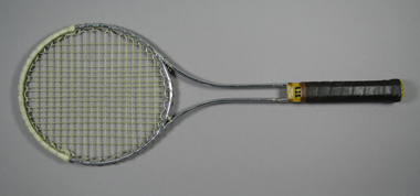
Racquet, Circa 1969
A Wilson 'T2000' metal tennis racquet, with double shaft; yellow plastic shaft casing & gold whipping. Handle wrapped with brown leather. Net anchored to metal wire wrapped around head frame. Yellow plastic butt cap with white label featuring 'W' logo in red. White plastic reinfrcement strip fixed around crown. Adhesive label inside shaft states: STRUNG WITH PRIDE & TLC/SOUTH COAST TENNIS & GOLF SHOPS. Materials: Metal, Plastic, Adhesive tape, Nylon, Adhesive label, String, Leathertennis -
 Kew Historical Society Inc
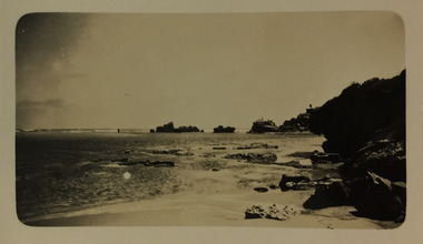
Photograph - Mouth of the Hopkins River, Point Ritchie, Warrnambool, c.1926
Henry Beater Christian (1886-1962) , was a descendant of one of the earliest settler families in Kew. Employed at the Kew Asylum as a 'public servant', he was a skilled amateur photographer, photographing numerous scenes in Kew and on his travels around Victoria. The majority of his photographs date from 1916 to 1929. His finest photographs are housed in two photograph albums. Digital copy of a photograph from page 23 of the 47-page photograph album containing 261 gelatinous silver images, loaned by Diane Washfold with permission given to digitise and hold a copy in our collection. Henry Christian took a number of walking and rail trips, individually or with friends, around regional and rural Victoria during the 1920s. This photo is from a series of twelve photographs of parts of the west coast of Victoria, including Port Fairy and Warrnambool. The location in this photograph has been identified by Kathleen Gervasoni as the mouth of the Hopkins River, Point Ritchie, Warrnambool. henry beater christian (1886-1962), landscape photography, christian-washfold collection, photograph albums, hopkins river, point ritchie, warrnambool -
 Kew Historical Society Inc
Photograph - River Moyne at Port Fairy, c.1926
Henry Beater Christian (1886-1962) , was a descendant of one of the earliest settler families in Kew. Employed at the Kew Asylum as a 'public servant', he was a skilled amateur photographer, photographing numerous scenes in Kew and on his travels around Victoria. The majority of his photographs date from 1916 to 1929. His finest photographs are housed in two photograph albums. Digital copy of a photograph from page 23 of the 47-page photograph album containing 261 gelatinous silver images, loaned by Diane Washfold with permission given to digitise and hold a copy in our collection. In the 1920s, the photographer travelled throughout Victoria, including on the west coast from Port Campbell to Port Fairy. Trips were presumably made by train and by foot. Lynda Tieman and her team at the Port Fairy Historical Society have tentatively identified a number of Henry Christian's photographs of Port Fairy, of which this is one. The scene is believed to be the River Moyne.henry beater christian (1886-1962), landscape photography, christian-washfold collection, photograph albums, river moyne, port fairy -
 Warrnambool and District Historical Society Inc.
Booklet - Booklet Collection: City of Warrnambool Tourist Guides, Collett, Bain and Gaspar, Warrnambool
This is a collection of sixteen tourist guides dating from the mid 1970's to 2013. These contain listings of businesses, accommodation, eateries and events in Warrnambool and district. They also include maps of Warrnambool and surrounds, advertising and photographs of various attractions. While mainly covering Warrnambool a small number of the guides cover the South West Region. These directories have mainly been published by the Warrnambool City Council and are a selection of the types of information provided to visitors at the Tourist information centre during this time period.These tourist guides give snapshots of the City of Warrnambool for the years covered and will be useful for research.[.1] An 8 page paper booklet with black printing and a black & white photo of the pond at the Botanical Gardens on the front cover. [.2] two photocopied A4 black and white pages from the book "On the Trail" K Winser 1956 (Main Roads of Australia) [.3] A trifold colour brochure with a stylised map of the coast on the yellow and blue front cover. The inside has stylised colour drawings on Warrnambool attractions. The rear cover has coloured photographs of bush, Liebig Street and Fletcher Jones gardens [.4] A trifold black and white brochure with a black line drawing of a whale on the front cover. [.5] A trifold white card with mauve printing. The front cover has a line drawing of the former Timor Street post office and a map of businesses and landmarks in Timor Street. The reverse side contains a brief history of Warrnambool. [.6] A 98 page stapled booklet with a foreword by Vanda Savill. There are 4 pages of coloured photographs. The remainder are black and white photographs. The front cover is purple with white writing in the lower third. There is an outline of the coast and five colour photographs of district attractions. The inside middle page has a map of the Western wonderland region. The content covers towns in this area. Content relating to Warrnambool is in the last six pages. [.7] Twelve loose photocopied black and white pages. The front cover has the Warrnambool Premier Town 1988-1991 logo and a photo of a Southern Right Whale and calf. The bottom right hand corner has a Standard Warrnambool logo. [.8] 44 page booklet printed with blue ink. The staples have been removed. The glossy front cover has blue printing with a coloured photo of Flagstaff Hill Maritime Village pond. The centre pages has a fold out map of the City of Warrnambool. The rear cover has photos of The Twelve Apostles and Hopkins Falls. [.9] 4 loose photocopied pages with Warrnambool Library and Corangamite Regional Library Service Warrnambool City Library black ink stamps. The front page line drawing illustrations of Warrnambool attractions [.10] A single sheet of glossy white paper folded in half to make four pages. The front page has a Warrnambool premier town logo 1979-1982 and blue printing and a visitor survey. [.11] A conference pack of light card folded to make a pocket containing three brochures, a shipwreck coast tourist directory and a Australian Heritage Parks Association conference program dated 24 to 27 May 1992. The front cover of the pack has green writing over a stylised upward arrow. There is a City of Warrnambool logo in the top right hand corner and two film strips diagonally across the cover containing photographs of Warrnambool. The rear cover has a coloured Warrnambool Premier Town logo. [.12] A 63 page stapled booklet with coloured photographs of Warrnambool. The front cover has black writing on white background. There is a coloured photograph of Flagstaff Hill in the middle of the cover and a Warrnambool City and Visit Victoria logos on the lower edge. The middle pages has a coloured of the city of Warrnambool with an inset map of Allansford. [.13] A single large sheet of white paper folded in ten to make a brochure. The front cover has black printing. The rear cover has a purple ink stamp for the City of Warrnambool Tourist Information Centre. When folded out the reverse side has a green, grey and white map of the South West Region of Victoria. [.14] A 48 page colour booklet on glossy paper. The front cover has white writing on a blue background and includes photographs of the Twelve Apostles, the Promenade walk, Flagstaff Hill and a southern right whale's tail. The rear cover has photographs of The Twelve apostles, a passenger train from Melbourne passing the Lake Pertobe playground, and a rural scene. There is white writing and a white Warrnambool City logo on a blue background. The centre pages have a stylised green and blue map of the city of Warrnambool. [.15] A 48 page colour booklet on glossy paper. The front cover has white writing over colour photographs of two people at a lookout, Flagstaff Hill, three southern right whales and a child at the Lake Pertobe playground. The lower edge has blue upper case writing on a white background. The rear cover has a colour photograph of the Twelve Apostles. The lower white border on the rear covers has a a blue and green City of Warrnambool logo and blue writing. The centre pages have a stylised green and blue map of the city of Warrnambool. [.16] A 64 page colour booklet on glossy paper. The front cover has black writing on a black background and there is a photograph of a southern right whale's tail. The lower edge has the Warrnambool City and Visit Victoria Logos. The centre pages have maps of Warrnambool and surrounds. [.1] This week in Warrnambool Vol 2 No. 5 Thurs 1st Feb. For the time of your life [.2] Warrnambool Way [.3] Warrnambool The Holiday Host on the South West Coast with compliments City of Warrnambool and Warrnambool Chamber of Commerce [.4] MMI Insurance presents Whales Giants of the Deep Whale Watcher's Logbook Warrnambool [.5] Warrnambool History began in Timor Street [.6] Western Wonderland Tourist Association [.7] A Premier Arrow Tour of Warrnambool Victoria's Premier Town Australia's Southern Right Whale Nursery [.8] Warrnambool The Heart of Victoria's Great Southwest Visitor's Handbook [.9] What to see in Warrnambool Victoria's Premier City 1979-1982 [.10] Win a Free Holiday & $200 Cash in Victoria's Premier Town [.11] Advancing Warrnambool together! [.12] Great Ocean Road Warrnambool Official Visitor Guide [.13] Tourist guide to the South West Region Victoria All it needs is you [.14] Warrnambool visitor guide 2005 the great ocean road experience attractions accommodation entertainment dining [.15] Warrnambool Visitor Guide 2006 the great ocean road experience Attractions Accommodation Entertainment Dining [.16] Official Visitors' Guide Warrnambool Victoria Australia Discover the Great Ocean Road warrnambool, warrnambool tourist guides -
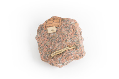 The Beechworth Burke Museum
Geological specimen - Granite
Gabo Island sits off the coast of East Gippsland in Victoria, with cliffs of granite in a relatively unique red/pink colour. Early attempts to build a lighthouse on the island were abandoned due to poor foundations, but when a ship ran aground on the nearby Tullaberga Island in 1853 and led to the death of 37 people, efforts were reignited. Construction of a new lighthouse was completed by 1858, using Gabo Island granite. The lighthouse is Australia's second tallest in Australia and continues to play an important role in guiding boats around the coast as they journey between Melbourne and Sydney. The distinct pink colour from the granite means the lighthouse continues to be a defining feature of the island. Gabo Island granite was also used to construct the Treasury Building at 117 Macquarie Street in Sydney, now the Intercontinental Hotel.Granite in the pink colour of this specimen is relatively rare. The connection to the lighthouse on Gabo Island also gives the specimen historic significance and social significance regarding the maritime history of Victoria. This specimen is part of a larger collection of geological and mineral specimens collected from around Australia (and some parts of the world) and donated to the Burke Museum between 1868-1880. A large percentage of these specimens were collected in Victoria as part of the Geological Survey of Victoria that begun in 1852 (in response to the Gold Rush) to study and map the geology of Victoria. Collecting geological specimens was an important part of mapping and understanding the scientific makeup of the earth. Many of these specimens were sent to research and collecting organisations across Australia, including the Burke Museum, to educate and encourage further study.A solid palm-sized mineral, coloured by flecks of pink, red, and grey. Granite is formed by the slow crystallisation of magma below the earth's surface. It is typically composed of a mix of quartz, feldspar, and other minerals, though syenitic granite like this sample has a smaller amount of quartz than typical granite. This different mineral composition leads to the more distinct pink and red colouring.First sticker: [torn]logical survey / R........ S........ / Loc Gabo Island / 1/4 Sheet / Second Sticker: 15 Third Sticker: Syenitic Graniteburke museum, beechworth, indigo shire, beechworth museum, geological, geological specimen, mineralogy, gabo island, gabo island lighthouse, lighthouse, granite, coast, coastal, granite specimen, victoria, coastal cliffs