Showing 2879 items
matching wellington
-
 Uniting Church Archives - Synod of Victoria
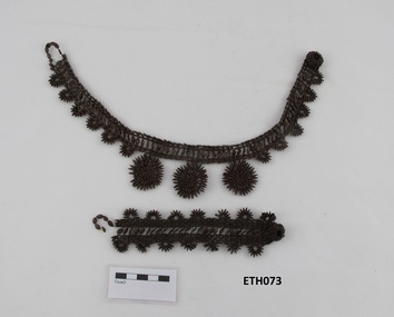
Accessory - Seed necklace and bracelet, c1850s
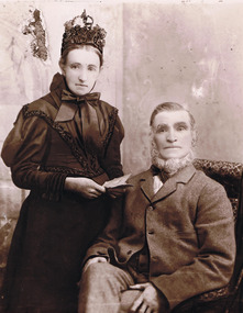
From the collection of the Rev James Watkin. From the collection of the Rev James Watkin. The Rev James Watkin, 1805-1886, was a Pioneer Wesleyan missionary. He was born in Manchester, UK, in 1805. In 1830 was accepted as a candidate for the Wesleyan Ministry and married Hannah Entwistle. They sailed with a missionary party to Tonga. The work of the mission was jeopardised by prolonged and involved struggles between Christian and non-Christian Tongan chiefs. He left with his family for Sydney in September 1837. He was offered a free passage for a missionary appointed to Waikouaiti, New Zealand and arrived there in May 1840. He established the first mission station in the South Island of New Zealand. Watkin established schools at Waikouaiti and Matanaka, and stationed partly trained Maori teachers at Stewart Island and at Moeraki. He had a natural flair for languages, preached in Maori four months after his arrival, and compiled an elementary reading book to be printed in Ngai Tahu. Watkin was relieved by Charles Creed and inWatkin finished his posiion in Waikouaiti in June 1844 when he sailed for Wellington, leaving 227 church members in Otago. In 1855 Watkin settled in New South Wales, Australia, and was president of the National Methodist Conference at Adelaide in 1862. He retired in 1869 and died on 14 May 1886, at Ashfield, New South Wales. Source: https://teara.govt.nz/en/1966/watkin-jamesETH073.1 dark brown wild tamarind seed necklace and ETH073.2 bracelet.rev james watkin -
 Uniting Church Archives - Synod of Victoria
Accessory - Wooden comb, c1850s
From the collection of the Rev James Watkin. From the collection of the Rev James Watkin. The Rev James Watkin, 1805-1886, was a Pioneer Wesleyan missionary. He was born in Manchester, UK, in 1805. In 1830 was accepted as a candidate for the Wesleyan Ministry and married Hannah Entwistle. They sailed with a missionary party to Tonga. The work of the mission was jeopardised by prolonged and involved struggles between Christian and non-Christian Tongan chiefs. He left with his family for Sydney in September 1837. He was offered a free passage for a missionary appointed to Waikouaiti, New Zealand and arrived there in May 1840. He established the first mission station in the South Island of New Zealand. Watkin established schools at Waikouaiti and Matanaka, and stationed partly trained Maori teachers at Stewart Island and at Moeraki. He had a natural flair for languages, preached in Maori four months after his arrival, and compiled an elementary reading book to be printed in Ngai Tahu. Watkin was relieved by Charles Creed and inWatkin finished his posiion in Waikouaiti in June 1844 when he sailed for Wellington, leaving 227 church members in Otago. In 1855 Watkin settled in New South Wales, Australia, and was president of the National Methodist Conference at Adelaide in 1862. He retired in 1869 and died on 14 May 1886, at Ashfield, New South Wales. Source: https://teara.govt.nz/en/1966/watkin-jamesMid nineteenth century wooden comb from Pacific Islands.rev james watkin -
 Uniting Church Archives - Synod of Victoria
Accessory - Woven bag, c1850s
From the collection of the Rev James Watkin. From the collection of the Rev James Watkin. The Rev James Watkin, 1805-1886, was a Pioneer Wesleyan missionary. He was born in Manchester, UK, in 1805. In 1830 was accepted as a candidate for the Wesleyan Ministry and married Hannah Entwistle. They sailed with a missionary party to Tonga. The work of the mission was jeopardised by prolonged and involved struggles between Christian and non-Christian Tongan chiefs. He left with his family for Sydney in September 1837. He was offered a free passage for a missionary appointed to Waikouaiti, New Zealand and arrived there in May 1840. He established the first mission station in the South Island of New Zealand. Watkin established schools at Waikouaiti and Matanaka, and stationed partly trained Maori teachers at Stewart Island and at Moeraki. He had a natural flair for languages, preached in Maori four months after his arrival, and compiled an elementary reading book to be printed in Ngai Tahu. Watkin was relieved by Charles Creed and inWatkin finished his posiion in Waikouaiti in June 1844 when he sailed for Wellington, leaving 227 church members in Otago. In 1855 Watkin settled in New South Wales, Australia, and was president of the National Methodist Conference at Adelaide in 1862. He retired in 1869 and died on 14 May 1886, at Ashfield, New South Wales. Source: https://teara.govt.nz/en/1966/watkin-jamesMid nineteenth century cylindrical woven carry bag with a lid attached and a platted handle. The bag has a brown pattern within the weaving at the top and bottom.rev james watkin, pioneer wesleyan missionary -
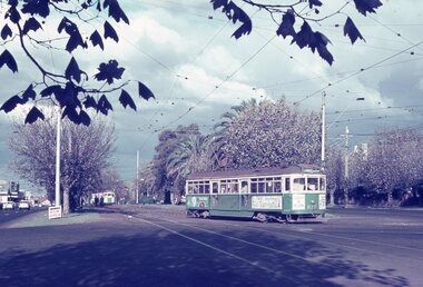
 Melbourne Tram Museum
Album - Robert Thomson Slide Collection, AETA Convention 1971
Photo - see pdf file for further information. Number Brief Description RT123 1971 Convention - 9.4.71 - tram 610 - "Special" - Wattle park terminus RT124 Mt Alexander Road - 980 - "Special" RT125 St Kilda Jct - 7.4.71 - "St Kilda Beach" - route 16 RT126 North Balwyn Terminus - 9.4.71 - tram 840 - "Nth Balwyn" route 79 RT127 Preston - tram 980 - "City - Spencer St" - route 9A RT128 St Kilda Jct - "E Brighton Malv Burke Rd" - route 64 RT129 St Kilda Park St Terminus 12.4.71 - tram 394 - "Special" & tram 1017 - "West Preston - Northcote" - route 10 RT130 Carnegie 9.4.71 - tram 106 - "St Kilda Jun" - route 17 RT131 High St - tram 980 - "East Preston" - route 98 RT132 St Kilda Park St Terminus 12.4.71 - tram 894 - "West Preston" - route 10 RT133 St Kilda Park St Terminus 12.4.71 - tram 894 - "West Preston" - route 10 RT134 Wattle Park - 9.4.71 - tram 610 - "City" - route 70 RT135 Wellington Parade - 9.4.71 - tram 840 - "City - Flinders & Spencer St Cnr" - route 23 RT136 Melville Rd West Coburg 12.4.71 - tram 787 - route 55 Demonstrates the work of Robert Thomson in photography, collection and/or production of slidesAssembled album in a black presentation folder of 14 colour slides, collected or produced by Robert Thomson. All photographs have been scanned and placed on the Museum's G drive. A list of all photographs with details has been compiled. melbourne, tramways, trams -
 Kew Historical Society Inc
Plan, Melbourne & Metropolitan Board of Works. Borough of Kew Detail Plan No.1579, 1904
The Melbourne and Metropolitan Board of Works (MMBW) plans were produced from the 1890s to the 1950s. They were crucial to the design and development of Melbourne's sewerage and drainage system. The plans, at a scale of 40 feet to 1 inch (1:480), provide a detailed historical record of Melbourne streetscapes and environmental features. Each plan covers one or two street blocks (roughly six streets), showing details of buildings, including garden layouts and ownership boundaries, and features such as laneways, drains, bridges, parks, municipal boundaries and other prominent landmarks as they existed at the time each plan was produced. (Source: State Library of Victoria). This plan forms part of a large group of MMBW plans and maps that was donated to the Society by the Mr Poulter, City Engineer of the City of Kew in 1989. Within this collection, thirty-five hand-coloured plans, backed with linen, are of statewide significance as they include annotations that provide details of construction materials used in buildings in the first decade of the 20th century as well as additional information about land ownership and usage. The copies in the Public Record Office Victoria and the State Library of Victoria are monochrome versions which do not denote building materials so that the maps in this collection are invaluable and unique tools for researchers and heritage consultants. A number of the plans are not held in the collection of the State Library of Victoria so they have the additional attribute of rarity.Original survey plan, issued by the MMBW to a contractor with responsibility for constructing sewers in the area identified on the plan within the Borough of Kew. The plan was at some stage hand-coloured, possibly by the contractor, but more likely by officers working in the Engineering Department of the Borough and later Town, then City of Kew. The hand-coloured sections of buildings on the plan were used to denote masonry or brick constructions (pink), weatherboard constructions (yellow), and public buildings (grey). While MMBW Plan No.1579 does not include many buildings, those that it does show are significant to Kew’s history. These include the ‘Kew [Railway] Station’ in Denmark Street and the ‘Recreation Hall’ and rear courts off Wellington Street. The plan shows the outline of the Recreation Hall, constructed in 1880, at the rear of which is listed a bowling green, two tennis courts, a ‘skittle alley’ and a pavilion. When the Hall was first built, the Kew Cricket Club occupied an adjacent ground, however in 1885 this was acquired by the State Government as the future location of the Kew Railway Station. The Plan also shows a single oval at Xavier College. This oval was completed in 1883. One of the current ovals conforms to this oval’s original shape and position in the school grounds.melbourne and metropolitan board of works, detail plans, maps - borough of kew, mmbw 1579, cartography -
 Marysville & District Historical Society
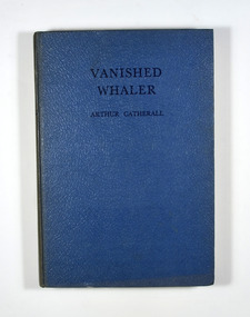
Book, Arthur Catherall, Vanished Whaler, 1953
Jim and his friend Nugget are air pilot and observer employed as scouts by a Norwegian whaling expedition. Sent out to find the Oslo, a whale-chaser which seems to be out of wireless touch with the parent ship, they find her all right, but deserted! Deserted in that desert of snow and ice the Antartic Circle. This is only the beginning of a great adventure, of plots and counter plots centered around a Spanish treasure-ship locked for three centuries in the ice.No dust cover. Book is bound in blue with the title and author in black on the front cover and the spine.fictionJim and his friend Nugget are air pilot and observer employed as scouts by a Norwegian whaling expedition. Sent out to find the Oslo, a whale-chaser which seems to be out of wireless touch with the parent ship, they find her all right, but deserted! Deserted in that desert of snow and ice the Antartic Circle. This is only the beginning of a great adventure, of plots and counter plots centered around a Spanish treasure-ship locked for three centuries in the ice.whaling, whaling ship, adventure, arthur catherall, fiction -
 Surrey Hills Historical Society Collection
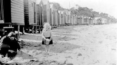
Photograph, Beatrice Mary Stalker, later Mrs Howard Breedon Everard, at the beach, 1930s
Mary Stalker’s engagement notice in The Argus in July 1947 indicates that she was the youngest daughter of Mr & Mrs A M Stalker of Montlare [Monclair] Avenue, North Brighton. It announces her engagement to ”Cr Howard Breedon Everard JP Ev-Ron, Woori Yallock, Youngest son of Hon WH Everard Wellington St Kew and the late Mrs Everard.” Beatrice Mary Stalker was born in 1919. Her parents were Alexander MacLaren Stalker (1885-1970/1973) and Charlotte Eleanor Hayward (1884-1953) who were married in 1911. Her sisters were Joan Winnock Stalker, Betty Neil Stalker and Ruth McLaren Stalker. Charlotte was a teacher prior to her marriage. Alexander, an accountant, lived in Wattle Valley Road, Canterbury in 1910. From 1912-1931 they are listed at ‘Benwerrin’, Wandsworth Road, Surrey Hills. Mary Stalker married in 1949 and by 1954 she and Howard were living at 44 Wandsworth Road, Surrey Hills, which was their home for decades. Howard was born in 1914 and died in October 2010: "EVERARD. - Howard Breedon. In loving memory of Howard, who lived life to the full to the very end of his 96 years. Greatly loved and honoured by Mary, Rosemary, David, Elizabeth, John and extended families." Beatrice Mary Everard died on 25 September 2019, aged 93. it is assumed that the woman in the photo is Mary's mother, Charlotte Eleanor Stalker (nee Hayward). The photo taken at the beach in 1930's may have been at Brighton, given the family’s later association with the suburb. This photo documents part of the social history of a family with a long and strong association with Surrey Hills. The backdrop of the typical bathing boxes used for changing into swimsuits, for lunch and for storing sports and beach gear, documents beach recreation and culture of the 1930s. Given the family's later residence in Brighton, this may well have been taken at Brighton Beach. For many years in the late nineteenth century, Brighton was Melbourne's favourite seaside destination. The now iconic bathing boxes were a response to Victorian ideas of morality and sea bathing. There are 82 Brighton bathing boxes, which protected by a heritage overlay because of their uniform scale and proportion, building materials, sentry order alignment. All retain their classic Victorian architectural features with timber framing, weatherboards and corrugated iron roofs. They remain as they did over one hundred years ago, as licensed bathing boxes. Service amenities such as electricity or water were never connected.A black and white photograph of a lady and little girl on the beach. There is a row of bathing boxes behind them.(miss) mary stalker, bathing boxes, (mrs) mary everard, (miss beatrice mary stalker, (mrs) beatrice mary everard, (mrs) charlotte eleanor stalker, (miss) charlotte eleanor hayward -
 Kew Historical Society Inc
Plan, Melbourne & Metropolitan Board of Works : Borough of Kew : Detail Plan No.1576, 1904
The Melbourne and Metropolitan Board of Works (MMBW) plans were produced from the 1890s to the 1950s. They were crucial to the design and development of Melbourne's sewerage and drainage system. The plans, at a scale of 40 feet to 1 inch (1:480), provide a detailed historical record of Melbourne streetscapes and environmental features. Each plan covers one or two street blocks (roughly six streets), showing details of buildings, including garden layouts and ownership boundaries, and features such as laneways, drains, bridges, parks, municipal boundaries and other prominent landmarks as they existed at the time each plan was produced. (Source: State Library of Victoria)This plan forms part of a large group of MMBW plans and maps that was donated to the Society by the Mr Poulter, City Engineer of the City of Kew in 1989. Within this collection, thirty-five hand-coloured plans, backed with linen, are of statewide significance as they include annotations that provide details of construction materials used in buildings in the first decade of the 20th century as well as additional information about land ownership and usage. The copies in the Public Record Office Victoria and the State Library of Victoria are monochrome versions which do not denote building materials so that the maps in this collection are invaluable and unique tools for researchers and heritage consultants. A number of the plans are not held in the collection of the State Library of Victoria so they have the additional attribute of rarity.Original survey plan, issued by the MMBW to a contractor with responsibility for constructing sewers in the area identified on the plan within the Borough of Kew. The plan was at some stage hand-coloured, possibly by the contractor, but more likely by officers working in the Engineering Department of the Borough and later Town, then City of Kew. The hand-coloured sections of buildings on the plan were used to denote masonry or brick constructions (pink), weatherboard constructions (yellow), and public buildings (grey). Development in the 20th century has irreparably altered that part of Kew represented in this plan. In the block bounded by Cotham Road, Charles Street, Wellington Street and Gellibrand; just one house standing in 1903 remains. This block included two of the most historic houses in Kew: ‘Ordsall’ (later ‘Southesk’) and ‘Madford’ (previously ‘Elm Lodge’). Ordsall was the home of the second chairman of Kew, John Halfey. It contained some of the most significant interior murals in Kew, created for Halfey by artists working for Cullen & Co. It was demolished in 1960 to make way for the Kew Civic Centre. Elm Lodge had been built for William Siddeley in ca. 1864. Arthur Septimus King purchased it in 1874. The lower paddocks of Madford were sold in 1905 by his wife to the Borough of Kew and, after landscaping by George and Thomas Pockett, opened as the Alexandra Gardens in 1908. Elm Lodge/Madford was in 1922 to become St. Anthony’s Home for Little Children before its subsequent demolition in the 1980s.melbourne and metropolitan board of works, detail plans, maps - borough of kew, mmbw 1576, cartography -
 Eltham District Historical Society Inc
Postcard - Photograph postcard, Old Bridge, Kaylock's Crossing, Brougham Street, Eltham, c.1912
Date estimated to be circa 1912 based on the style of printing on the reverse of the card - Kodak Austral paper for real photo postcards, the paper was manufactured c.1908-1914 (See also POSTCARDS ON KODAK PAPER - IS IT POSSIBLE TO "DATE" THEM? http://tps.org.au/bb/viewtopic.php?t=115) Brougham Street was created in Josiah Holloway's 1851 subdivision of Little Eltham. It was one of several east-west streets shown on the subdivision plan as crossing the Diamond Creek. The western part was named Wellington Street on the subdivision plan but was later changed to conform with the name of the eastern part as acknowledgement of the continuity of the street. It is not known when the first bridge was constructed in Brougham Street however it was certainly mentioned at Council’s meeting of 2 June 1884 as being in a dangerous state of repair. This photo (c.1895) of an old bridge shows a very low-level simple log girder bridge crossing the creek at a right angle and so the approaches involved bends in the road alignment. This bridge was generally known as Kaylocks Bridge or Kaylock’s Crossing after the owner of the adjoining land. It was most likely built from around the mid-1850s, or a crossing of some fashion established as Richard George Kaylock, butcher of Little Eltham and his wife Emily Ann settled there in 1854. His property was in Wellington Street (now Brougham Street) and apparently extended across the Diamond Creek. The land on the western side of the creek was farmed, the house being on the eastern side. Kaylock's Bridge formed part of the original coach road to Eltham and in 1922 was described as an "old rustic bridge". Its low level and insubstantial construction made it susceptible to flood damage, necessitating frequent closures until repairs could be carried out. In September 1922, Council called for tenders for a new timber bridge to be constructed at Kaylock’s crossing. An engineering assessment carried out for the Council by Macleod Consulting at the time of the replacement suggested that the construction details indicate that it was in the 1900s, however this dating could possibly have been the result of numerous repairs undertaken over the years to flood damage. The tender was awarded to Mr Weller of Kangaroo Ground who commenced work in February 1923 on a higher-level timber trestle bridge. Work was slowed due to illness of the contractor and the accidental death of a man in March 1923 following the collapse of the bank after he had jumped into a hole that had just been blasted. The bridge was completed around July 1923 at which point the old structure was pulled up, marking what was described in the ‘Advertiser’ newspaper as the passing of an old and well-loved landmark in the district. In April 1924 the approach to Kaylocks bridge was washed away during the heavy flooding that destroyed the Main Road bridge. The western side was repaired, and an extra span was added to the eastern side using timber from the destroyed Main Road bridge. The bridge was again severely damaged four months later in August 1924 When a lack of finances delayed repairs to the Bridge Street bridge in 1931 (also referred to as Obelisk Bridge at the time), traffic had to detour via Brougham Street for some time. Local residents feared that the Bridge Street bridge might never reopen. Kaylocks Bridge was constantly subject to damage by floods. In the 1934 flood it was submerged by two feet of water. In more recent times the bridge was again severely damaged by flooding and repairs made. A new bridge and adjoining footbridge were constructed in 2009.Digital file only Postcards scanned from the collection of Michael Aitken on loan to EDHS, 2 Sep. 2022michael aitken collection, eltham, postcards, bridge, brougham street, diamond creek (creek), kaylocks bridge, wellington street -
 Eltham District Historical Society Inc
Photograph, Old Bridge, Kaylock's Crossing, Brougham Street, Eltham, c.1895
Brougham Street was created in Josiah Holloway's 1851 subdivision of Little Eltham. It was one of several east-west streets shown on the subdivision plan as crossing the Diamond Creek. The western part was named Wellington Street on the subdivision plan but was later changed to conform with the name of the eastern part as acknowledgement of the continuity of the street. It is not known when the first bridge was constructed in Brougham Street however it was certainly mentioned at Council’s meeting of 2 June 1884 as being in a dangerous state of repair. This photo (c.1895) of an old bridge shows a very low-level simple log girder bridge crossing the creek at a right angle and so the approaches involved bends in the road alignment. This bridge was generally known as Kaylocks Bridge or Kaylock’s Crossing after the owner of the adjoining land. It was most likely built from around the mid-1850s, or a crossing of some fashion established as Richard George Kaylock, butcher of Little Eltham and his wife Emily Ann settled there in 1854. His property was in Wellington Street (now Brougham Street) and apparently extended across the Diamond Creek. The land on the western side of the creek was farmed, the house being on the eastern side. Kaylock's Bridge formed part of the original coach road to Eltham and in 1922 was described as an "old rustic bridge". Its low level and insubstantial construction made it susceptible to flood damage, necessitating frequent closures until repairs could be carried out. In September 1922, Council called for tenders for a new timber bridge to be constructed at Kaylock’s crossing. An engineering assessment carried out for the Council by Macleod Consulting at the time of the replacement suggested that the construction details indicate that it was in the 1900s, however this dating could possibly have been the result of numerous repairs undertaken over the years to flood damage. The tender was awarded to Mr Weller of Kangaroo Ground who commenced work in February 1923 on a higher-level timber trestle bridge. Work was slowed due to illness of the contractor and the accidental death of a man in March 1923 following the collapse of the bank after he had jumped into a hole that had just been blasted. The bridge was completed around July 1923 at which point the old structure was pulled up, marking what was described in the ‘Advertiser’ newspaper as the passing of an old and well-loved landmark in the district. In April 1924 the approach to Kaylocks bridge was washed away during the heavy flooding that destroyed the Main Road bridge. The western side was repaired, and an extra span was added to the eastern side using timber from the destroyed Main Road bridge. The bridge was again severely damaged four months later in August 1924 When a lack of finances delayed repairs to the Bridge Street bridge in 1931 (also referred to as Obelisk Bridge at the time), traffic had to detour via Brougham Street for some time. Local residents feared that the Bridge Street bridge might never reopen. Kaylocks Bridge was constantly subject to damage by floods. In the 1934 flood it was submerged by two feet of water. In more recent times the bridge was again severely damaged by flooding and repairs made. A new bridge and adjoining footbridge were constructed in 2009. Part of a slide show presentation "Bridges & Waterways of the Shire" by Russell Yeoman to the 13 September 1989 Society meeting. The presentation included slides of historic photos from the Shire of Eltham Pioneers collections as well as several recent views.Photo of earliest known crossing of the Diamond Creek at brougham StreetPostcard photo printbrougham street, eltham, wellington street, kaylocks bridge, bridge, diamond creek (creek) -
 Eltham District Historical Society Inc
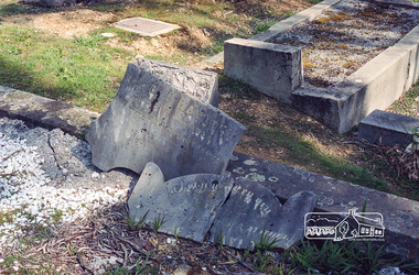
Negative - Photograph, Harry Gilham, Grave of Richard George, Emily Ann (nee Davis) and Edith Jane Kaylock, Eltham Cemetery, Victoria, Sep 2009
In his early adult life, Richard Kaylock worked as a whaler (visiting California and New Zealand) and later as a drover on a large cattle station in New South Wales. In 1848 he came to Melbourne, working as a slaughterman, then settled in Eltham in 1854, his occupation thereafter being variously recorded as butcher or orchardist. He also had some experiences at Ballarat during the Eureka Rebellion. He died in 1910 at the age of 84. His obituary described him as a "striking personality" who was "brusque to a fault" and "strictly upright, expecting others to be the same". It seems from his will that he was illiterate. He is buried in Eltham Cemetery with his wife Emily. His property was in Wellington Street (now Brougham Street) and apparently extended across the Diamond Creek. The land on the western side of the creek was farmed, the house being on the eastern side. For many years the Brougham Street bridge was generally known as "Kaylock's Bridge". It formed part of the original coach road to Eltham and in 1922 was described as an "old rustic bridge". Its low level and insubstantial construction made it susceptible to flood damage, necessitating frequent closures until repairs could be carried out. The original bridge was demolished in 1923 and replaced by a "new up-to-date" one. When a lack of finances delayed repairs to the Bridge Street bridge in 1931, traffic had to detour via Brougham Street for some time. Local residents feared that the Bridge Street bridge might never reopen. In Loving Memory Of Our Dear Father & Mother R.G. and E.A. Kaylock Also E.J. Kaylock Died 21st Jan. 1927 The Eternal God Is My PledgeRoll of 35mm colour negative film, 6 stripsKodak GC 400-9eltham cemetery, gravestones, edith jane kaylock, emily ann kaylock (nee davis), richard george kaylock, brougham street bridge, kaylocks bridge -
 Eltham District Historical Society Inc
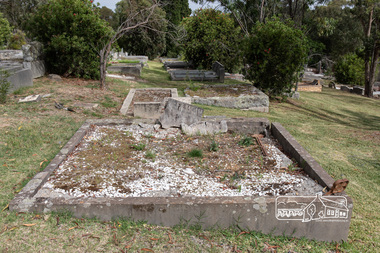
Photograph, Peter Pidgeon, Grave of Richard George, Emily Ann (nee Davis) and Edith Jane Kaylock, Eltham Cemetery, Victoria, 5 April 2021
In his early adult life, Richard Kaylock worked as a whaler (visiting California and New Zealand) and later as a drover on a large cattle station in New South Wales. In 1848 he came to Melbourne, working as a slaughterman, then settled in Eltham in 1854, his occupation thereafter being variously recorded as butcher or orchardist. He also had some experiences at Ballarat during the Eureka Rebellion. He died in 1910 at the age of 84. His obituary described him as a "striking personality" who was "brusque to a fault" and "strictly upright, expecting others to be the same". It seems from his will that he was illiterate. He is buried in Eltham Cemetery with his wife Emily. His property was in Wellington Street (now Brougham Street) and apparently extended across the Diamond Creek. The land on the western side of the creek was farmed, the house being on the eastern side. For many years the Brougham Street bridge was generally known as "Kaylock's Bridge". It formed part of the original coach road to Eltham and in 1922 was described as an "old rustic bridge". Its low level and insubstantial construction made it susceptible to flood damage, necessitating frequent closures until repairs could be carried out. The original bridge was demolished in 1923 and replaced by a "new up-to-date" one. When a lack of finances delayed repairs to the Bridge Street bridge in 1931, traffic had to detour via Brougham Street for some time. Local residents feared that the Bridge Street bridge might never reopen. In Loving Memory Of Our Dear Father & Mother R.G. and E.A. Kaylock Also E.J. Kaylock Died 21st Jan. 1927 The Eternal God Is My PledgeBorn Digitaleltham cemetery, gravestones, brougham street bridge, edith jane kaylock, emily ann kaylock (nee davis), kaylocks bridge, richard george kaylock -
 Bendigo Military Museum
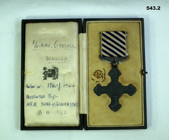
Award - MEDAL DFC, C.1944 - 46
Allan Frederick GOODALL DFC. Allan enlisted in the RAAF on 10.10.1941 No 409828 age 18 years. He was mustered as Aircrew on elisted and was designated as WO/AG ( Wireless operator Air Gunner) on 23.7.1942. he rose through the ranks from AC2, LAC, Sgt, F/Sgt, W/O, F/O to Flt/Lt on 1.3.1945. Embarked for England on 24.8.1942 and posted to RAF Station Bournemouth on 18 .11.1942, posted to MEC (Middle East Command) with 150 Sqd RAF flying Wellingtons from North Africa. On 21.12.1943 on a non operational flight from Africa to Italy his flight crashed into Mt Etna, they were coming out of a cloud when the Pilot saw Etna. Allan as least injured made sure his mates were okay and sheltered he walked down to a nearby village (Maletto) to get help. Allan spent from 21.12.1943 to 5.1.1944 in hospital with Abrasions. He was awarded the DFC (Distinguished Flying Cross) in 1944 for operations over Italy, at the time he was classed as Sqd Signals Leader. According to his records he flew 37 Operational sorties. He was discharged from the RAAF on 3.1.1946. The crew of the Plane were; Bruce Hayman (NZ) Pilot, Fractured leg. Allan Goodall Aust (WOP/AG) abrasions and injured wrist. Alan Warner (Aust) Navigator, Fractured Ankle. Y.F.Redknap (UK) injured shoulder. C.A. Carr (UK) Fractured Dorsal Spine. J.E. Ward (UK) Dislocated shoulder. Alfred Dugdale (UK) Deceased. Tony Moore (UK) Deceased. Both are buried at the Catania War Cemetery Sicily. Refer Cat No 1025P for his photo.543.1 Medal-Distinguished FLying Cross won by FO Alan F Goodall. Rear of medal is engraved "Italy FO Alan Goodall 1944" 543.2 Case-to suit DFC above. Case rear has a note "Alan's sister Jean, Mrs R.T Mitchell, 22 O'Dea Cres Kangaroo Flat 3555 471428." Written inside case in pen "F/O Alan Goodall Bendigo Won in Italy 1944 Presented by HRH Duke of Gloucester 13-11-1946"awards, dfc ww2, raaf -
 Melbourne Tram Museum
Album - Robert Thomson Slide Collection, "Melbourne 1968"
4182 - Box 2 - Melbourne 1968 (RT033-054) RT033 Dandenong Rd - tram 870 - "St Kilda Bch - Balaclava Rd" - route 69 RT034 St Kilda Rd - tram 262 - "South Melb Beach" - route 2A RT035 Sth Melb Beach Ter - tram 262 - "City" - route 2A RT036 Wallen Rd - tram 923 - "City" - route 70 RT037 Dandenong Rd - tram 438 - "Malvern - Burke Rd" - route 5 RT038 Batman Ave Ter - tram 851 - "Wattle Park Warrigal Rd" - route 70 RT039 Batman Ave - tram 864 - "City" - route 70 RT040 Princes Bridge - tram 874 - "Moreland" - route 15 RT041 E Brunswick Ter - tram 1038 - "City - Spencer St" - route 96 RT042 Victoria Pde - tram 673 - "South Melb & St Kilda Beach" - route 12 RT043 Dandenong Rd at St Kilda Junction? RT044 Dandenong Rd at St Kilda Junction? RT045 St Kilda Jct? RT046 Wellington St - tram 811 - "City" - route 64 RT047 St Kilda Jct RT048 St Kilda Jct? - trams 968 & 902 - "Carnegie" & "City" route 4 RT049 St Kilda Jct? - trams 968 & 902 - "Carnegie" & "City" route 4 RT050 Carnegie Single Line - tram 774 - "City" - route 4 RT051 Nth Fitzroy Depot - buses RT052 Wattle Park Single Line - tram 823 - "Wattle Park Elgar Rd" - route 70 RT053 Wattle Park Single Line - tram 371 - "Wattle Park Elgar Rd" - route 70 RT054 Essendon Reserved Track - tram 449 - "City" - route 59Demonstrates the work of Robert Thomson in photography, collection and/or production of slidesAssembled album in a black presentation folder of 22 colour slides, collected or produced by Robert Thomson. All photographs have been scanned and placed on the Museum's G drive. A list of all photographs with details has been compiled. melbourne, tramways, trams, track construction -
 Federation University Historical Collection
Magazine - Book, St Patrick's College Annual Magazine, 1930-31, 1930-1931
School Magazine of St Patrick's College, Ballarat. Includes a boarders' Roll Call. Articles include: Ballarat Still a Golden City, What Shall I Be? Images:S.P.C. From the Air, Senior Dormitory, A Scene in the Botanical Gardens, Ballarat, dining rooom, Christian Brothers' Novitate and Training College, Strathfield, N.S.W. Advertisements: Ballarat Trustees, Heinz Brothers Butchers, Middleton and Morris, National Trustees, F. Cannon Hairdresser, G. Werner & Co, Clegg, Miller and Morrow, Rowlands, Gordon Brothers, Loreto Convent, St Alysius Junior Boys' School Portland, Coghlan Boase and Co, Briant's Red Shop Tea Rooms, Ballarat Supply Stores, Stephen Wellington furnishing undertaker, W. Cornell, Eden Photographs, W.E. Longhurst Bread, Sacred Heart Boarding School, St Anes' Ladies' College Geelong, Ballarat Brewing Company, J.S. Young Suit Builders, George Smithm, Kearns Brothers Fish and Oyster Saloon, T.G. Skewes Pharmacy, J.A. Reynolds Wal paper Wahehouse, Walter Gude Music Teacher, Snows, Auldana Wines, J. Ewins Book Store, Cowdell, Tonner and Ellis, Richards and Co, Kruse's Fluid Magnesia, Jago's Ballarat Boot Palace, R.J. Miller Undertaker, W.C. Thomas and Sons Flour Millers, Broadbent Bros, W.E. Thomas American Dentist, Harry Davies and Co., Permewan Wright, William P. Linehan, Tyler's Clothing Arcadem C. Marks and Co, Coad and Hewitson Chaff Cutters.Written on first page Walsh, Vectis South, Horsham.st patrick's college ballarat, rev. dr. foley, rev. dr higgins, br keniry, thomas walsh, j. guinane, irish national forresters, gerald o'day, p. ryan, frank keys, l. bartels, g. hickey, t. keys, o. daly, j. wolf, a. mckean, t.h. jenkins, dr devine, j. sowersby, gerard little, rev. j. mchugh, andrew mulquiney, bernard heinz, ballarat trustees, heinz brothers butchers, middleton and morris, national trustees, f. cannon hairdresser, g. werner & co, clegg, miller and morrow, gordon brothers, loreto convent, st alysius junior boys' school portland, coghlan boase and co, briant's red shop tea rooms, ballarat supply stores, stephen wellington furnishing undertaker, w. cornell, eden photographs, w.e. longhurst bread, sacred heart boarding school, st anes' ladies' college geelong, ballarat brewing company, j.s. young suit builders, george smith, kearns brothers fish and oyster saloon, t.g. skewes pharmacy, j.a. reynolds wal paper warehouse, walter gude music teacher, snows, auldana wines, j. ewins book store, cowdell, tonner and ellis, richards and co, kruse's fluid magnesia, jago's ballarat boot palace, r.j. miller undertaker, w.c. thomas and sons flour millers, broadbent bros, w.e. thomas american dentist, harry davies and co., permewan wright, william p. linehan, tyler's clothing arcade, c. marks and co, coad and hewitson chaff cutters, loreto convent portland -
 Kew Historical Society Inc
Plan, Melbourne & Metropolitan Board of Works : Borough of Kew : Detail Plan No.1574, 1905
The Melbourne and Metropolitan Board of Works (MMBW) plans were produced from the 1890s to the 1950s. They were crucial to the design and development of Melbourne's sewerage and drainage system. The plans, at a scale of 40 feet to 1 inch (1:480), provide a detailed historical record of Melbourne streetscapes and environmental features. Each plan covers one or two street blocks (roughly six streets), showing details of buildings, including garden layouts and ownership boundaries, and features such as laneways, drains, bridges, parks, municipal boundaries and other prominent landmarks as they existed at the time each plan was produced. (Source: State Library of Victoria)This plan forms part of a large group of MMBW plans and maps that was donated to the Society by the Mr Poulter, City Engineer of the City of Kew in 1989. Within this collection, thirty-five hand-coloured plans, backed with linen, are of statewide significance as they include annotations that provide details of construction materials used in buildings in the first decade of the 20th century as well as additional information about land ownership and usage. The copies in the Public Record Office Victoria and the State Library of Victoria are monochrome versions which do not denote building materials so that the maps in this collection are invaluable and unique tools for researchers and heritage consultants. A number of the plans are not held in the collection of the State Library of Victoria so they have the additional attribute of rarity.Original survey plan, issued by the MMBW to a contractor with responsibility for constructing sewers in the area identified on the plan within the Borough of Kew. The plan was at some stage hand-coloured, possibly by the contractor, but more likely by officers working in the Engineering Department of the Borough and later Town, then City of Kew. The hand-coloured sections of buildings on the plan were used to denote masonry or brick constructions (pink), weatherboard constructions (yellow), and public buildings (grey). This plan shows several very large houses, particularly along Glenferrie Road, and the area now occupied by Ruyton Girls’ School. ‘Tarring’ (incorrectly spelled here as ‘Karring’) was built for Henry Henty in 1872, on part of his original allotment of 20 acres, and ‘Mount View’, which retains its original building and the fountain in the front garden, is part of Ruyton’s Junior School. The most significant change to Tarring and its grounds since 1903, involve the removal of a number of the outbuildings, including a Burmese temple, bought by Henty from the Burmese Exhibit at the Great Exhibition of 1880. It is shown on the plan as a summerhouse. The two-storey mansion, on the corner of Glenferrie Road and Wellington Street, was built in 1891 by leading architect Alfred White as his own home. Having an initial N.A.V. of £160, the house was purchased by a warehouseman Henry Lister, by 1900, when the N.A.V. was recorded at £111. By the turn of the century the house was known as ‘Comaques’. By contrast, much smaller houses are shown in Scott and Byron Streets, including a tiny Mission Hall in Byron Street, which belonged to the Anglican Church from at least 1903 to 1917.melbourne and metropolitan board of works, detail plans, maps - borough of kew, mmbw 1574, cartography -
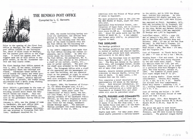 Bendigo Historical Society Inc.
Document - LONG GULLY HISTORY GROUP COLLECTION: THE BENDIGO POST OFFICE
Article titled The Bendigo Post Office, compiled by L C Bennetts. Mentioned is the history of the Bendigo Post Office and postmarks, some information on mining, Bendigo foundries, Underground connections of mines, expenses and shaft sinking costs. Also mentioned is Bendigo and Eaglehawk - 60 years ago and the role the pubs played in daily living. They were where theatres, concerts and dances were held, and the meeting rooms for clubs and lodges, even church benefits. Listed is a number of Bendigo hotels. Some even had a few names. Names of the pubs are: The Freemasons, The Courthouse, The Commercial Law Courts, The Hamburg, The European, The Prince Bismark, The Lord Kitchener, The Bendigo, The Rosalind Park, The Showgrounds, Atheneum Club, Olivers, Bridge Hotel, Bourkes, The Globe, The Hibernia, Albert, Albion, Abbotts, Australian, Belvidere, Beehive, British Queen, Black Eagle, British and American, Brian Boru, Bakers Arms, Butchers Arms, Brick Layers Arms, Bull and Mouth, Cresent, Clarence, Back Creek Bridge, Cape Clear, Crooked Billet, Cambridgeshire Arms, Camp, Coach and Horses, Cricketers Arms, Diggers Rest, Ellesmere, Five Lions, Franklyn, Golden Square, Golden Gate, Golden Gully, Golden Age, Golden Vine, Gumtree, Glasgow Reef, Great Britain, Haymarket, Daniel O'Connell, Half Way House, Fleece Inn, Ironbark, Johnsons Reef, Lancashire, Live and Let Live, Manchester Arms, Gold Mines, Metropolitan, Crown, National, New Chum, Honeysuckle Street, Pavilion, Napier Arms, Quartz Miners Arms, Retreat Inn, Rainbow, Rose of Australia, Lake View, Robin Hood, Fountain, Southern Cross, Bath, Berlin, Spring Gully, Star, Sir Charles Hotham, Silvermines, Royal Oak, Suburban, Town Hall, Temperance, Ship Inn, View Point, View Bend, Victoria, Exchange, American, Arcade, Belfast, All Nations, Union, United Kingdom, Union Jack, Westend, Washington, Waterloo, Wellington, Whitehorse, Wheat Sheaf, Yorkshire, Niagra and Noahs Ark.bendigo, history, long gully history group, the long gully history group - the bendigo post office, l c bennetts, mt alexander post office, porcupine inn, cenotaph, pike or pyke, baby health centre, sandhurst post office, government survey office, queen elizabeth oval, sandhurst trustees company, mr h b briston, savings bank, telegraph office, the sub-treasury, sir henry brougham lock kcb, sir john nimmo mla, prince of wales group of mines, the new prince of wales, eaglehawk golf links, new prince of wales no 2, the whip and jersey, mines department, lansell's big 180, new chum and victoria mine and battery, new chum railway, koch's pioneer, south new moon, catherine reef united, new moon, the virginia, south bell vue, central nell gwynne, north nell gwynne, miner's phthisis, hercules engine house, ironbark, new chum syncline, hercules energetic, roberts & sons, harkness & co, horwoods, great southern, ulster, carlisle, lansells big 180, victoria quartz, new st mungo, duchess tribute, south devonshire, hopewell mine, saxby mine, mcnair & co, shamrock, mr king, burke and wills expedition, sandhurst hotel, courthouse, hiberian, the freemasons, the courthouse, the commercial law courts, the hamburg, the european, the prince bismark, the lord kitchener, the bendigo, the rosalind park, the showgrounds, atheneum club, olivers, bridge hotel, bourkes, the globe, the hibernia, albert, albion, abbotts, australian, belvidere, beehive, british queen, black eagle, british and american, brian boru, bakers arms, butchers arms, brick layers arms, bull and mouth, cresent, clarence, back creek bridge, cape clear, crooked billet, cambridgeshire arms, camp, coach and horses, cricketers arms, diggers rest, ellesmere, five lions, franklyn, golden square, golden gate, golden gully, golden age, golden vine, gumtree, glasgow reef, great britain, haymarket, daniel o'connell, half way house, fleece inn, ironbark, johnsons reef, lancashire, live and let live, manchester arms, gold mines, metropolitan, crown, national, new chum, honeysuckle street, pavilion, napier arms, quartz miners arms, retreat inn, rainbow, rose of australia, lake view, robin hood, fountain, southern cross, bath, berlin, spring gully, star, sir charles hotham, silvermines, royal oak, suburban, town hall, temperance, ship inn, view point, view bend, victoria, exchange, american, arcade, belfast, all nations, union, united kingdom, union jack, westend, washington, waterloo, wellington, whitehorse, wheat sheaf, yorkshire, niagra, noahs ark -
 Bendigo Historical Society Inc.
Photograph - Historical Society Field Trip to the Springs at Sedgwick, Abt 2009
The Phil Wilkin Collection contains a series of 11 Items. The related items can be found by clicking on the reference link below. The following history of the Young family and their descendants who lived at the Springs is provided by Phil Wilkin. His Great Grandparents were Frances Young and August Wirth. Phil has also provided notes on the Wilkin Family and some history of the gold mining in Sedgwick. Frances Young's parents Joseph and Margaret Young owned the property called "The Old Place, Preston Vale or Wellington Flat" at Sedgwick near the Springs. Joseph Young owned and Managed the Standard Brewery which was located at Campbells Creek during the late 1800’s early 1900’s. Joseph and Margaret are buried in the Harcourt cemetery. In 1880 August Wirth lived at Mosquito Creek (Lake Eppalock, Victoria) when he married Frances Young. In 1902 they moved to part of Joseph Young's property. They milked cows and sold cattle for a living. One of their children Charles Wirth (Phil Wilkin's Grandfather) bought the land in 1935 after his parents had died. Charles Wirth was a councillor and also was president of the Shire of Strathfieldsaye. The "Old Place" was part of the property owned by members of the family. The old house at the Springs was burnt out by bushfire in January 1944 and much of the stonework was later vandalized by campers. The original Coliban Water Works were designed in 1863 by the Irish engineer Joseph Brady. The system included 70 kilometres of open water channels, aqueducts, syphons and tunnels to carry water (by gravity) from the Coliban River at Malmsbury, north to Castlemaine and Bendigo. Sedgwick is a locality in Central Victoria, Australia. It is located in the City of Greater Bendigo. Facilities include a public hall that opened in 1958 and CFA Rural fire station. It was named Upper Emu Creek until 1901 when it was renamed as Sedgwick after British geologist Adam Sedgwick.Twenty nine photos taken on a field trip by the Bendigo Historical Society to "The Springs" on the main Coliban water channel from Malmsbury to the Sandhurst Reservoir in Bendigo. The water race descends through a concrete chute, and continues sharply around the contour of the hills. Once it descended into a syphon across the gully. The are 182 photos in this series and can be found at 8683.1 to 8683.11. The series also includes photos of the surrounding farming land and the remains of an old house. There are also some notes on the pioneers of the district.history, bendigo, coliban water, joseph brady, irrigation, the springs, sedgwick -
 Bendigo Historical Society Inc.
Photograph - Historical Society Field Trip to the Springs at Sedgwick, Abt 2009
The Phil Wilkin Collection contains a series of 11 Items. The related items can be found by clicking on the reference link below. The following history of the Young family and their descendants who lived at the Springs is provided by Phil Wilkin. His Great Grandparents were Frances Young and August Wirth. Phil has also provided notes on the Wilkin Family and some history of the gold mining in Sedgwick. Frances Young's parents Joseph and Margaret Young owned the property called "The Old Place, Preston Vale or Wellington Flat" at Sedgwick near the Springs. Joseph Young owned and Managed the Standard Brewery which was located at Campbells Creek during the late 1800’s early 1900’s. Joseph and Margaret are buried in the Harcourt cemetery. In 1880 August Wirth lived at Mosquito Creek (Lake Eppalock, Victoria) when he married Frances Young. In 1902 they moved to part of Joseph Young's property. They milked cows and sold cattle for a living. One of their children Charles Wirth (Phil Wilkin's Grandfather) bought the land in 1935 after his parents had died. Charles Wirth was a councillor and also was president of the Shire of Strathfieldsaye. The "Old Place" was part of the property owned by members of the family. The old house at the Springs was burnt out by bushfire in January 1944 and much of the stonework was later vandalized by campers. The original Coliban Water Works were designed in 1863 by the Irish engineer Joseph Brady. The system included 70 kilometres of open water channels, aqueducts, syphons and tunnels to carry water (by gravity) from the Coliban River at Malmsbury, north to Castlemaine and Bendigo. Sedgwick is a locality in Central Victoria, Australia. It is located in the City of Greater Bendigo. Facilities include a public hall that opened in 1958 and CFA Rural fire station. It was named Upper Emu Creek until 1901 when it was renamed as Sedgwick after British geologist Adam Sedgwick.Twenty five photos taken on a field trip by the Bendigo Historical Society to "The Springs" on the main Coliban water channel from Malmsbury to the Sandhurst Reservoir in Bendigo. The water race descends through a concrete chute, and continues sharply around the contour of the hills. Once it descended into a syphon across the gully. The are 182 photos in this series and can be found at 8683.1 to 8683.11. The series also includes photos of the surrounding farming land and the remains of an old house. There are also some notes on the pioneers of the district.history, bendigo, coliban water, joseph brady, irrigation, the springs, sedgwick -
 Bendigo Historical Society Inc.
Photograph - Historical Society Field Trip to the Springs at Sedgwick, Abt 2009
The Phil Wilkin Collection contains a series of 11 Items. The related items can be found by clicking on the reference link below. The following history of the Young family and their descendants who lived at the Springs is provided by Phil Wilkin. His Great Grandparents were Frances Young and August Wirth. Phil has also provided notes on the Wilkin Family and some history of the gold mining in Sedgwick. Frances Young's parents Joseph and Margaret Young owned the property called "The Old Place, Preston Vale or Wellington Flat" at Sedgwick near the Springs. Joseph Young owned and Managed the Standard Brewery which was located at Campbells Creek during the late 1800’s early 1900’s. Joseph and Margaret are buried in the Harcourt cemetery. In 1880 August Wirth lived at Mosquito Creek (Lake Eppalock, Victoria) when he married Frances Young. In 1902 they moved to part of Joseph Young's property. They milked cows and sold cattle for a living. One of their children Charles Wirth (Phil Wilkin's Grandfather) bought the land in 1935 after his parents had died. Charles Wirth was a councillor and also was president of the Shire of Strathfieldsaye. The "Old Place" was part of the property owned by members of the family. The old house at the Springs was burnt out by bushfire in January 1944 and much of the stonework was later vandalized by campers. The original Coliban Water Works were designed in 1863 by the Irish engineer Joseph Brady. The system included 70 kilometres of open water channels, aqueducts, syphons and tunnels to carry water (by gravity) from the Coliban River at Malmsbury, north to Castlemaine and Bendigo. Sedgwick is a locality in Central Victoria, Australia. It is located in the City of Greater Bendigo. Facilities include a public hall that opened in 1958 and CFA Rural fire station. It was named Upper Emu Creek until 1901 when it was renamed as Sedgwick after British geologist Adam Sedgwick.Twenty six photos taken on a field trip by the Bendigo Historical Society to "The Springs" on the main Coliban water channel from Malmsbury to the Sandhurst Reservoir in Bendigo. The water race descends through a concrete chute, and continues sharply around the contour of the hills. Once it descended into a syphon across the gully. The are 182 photos in this series and can be found at 8683.1 to 8683.11. The series also includes photos of the surrounding farming land and the remains of an old house. There are also some notes on the pioneers of the district.history, bendigo, coliban water, joseph brady, irrigation, the springs, sedgwick -
 Bendigo Historical Society Inc.
Photograph - Historical Society Field Trip to the Springs at Sedgwick, Abt 2009
The Phil Wilkin Collection contains a series of 11 Items. The related items can be found by clicking on the reference link below. The following history of the Young family and their descendants who lived at the Springs is provided by Phil Wilkin. His Great Grandparents were Frances Young and August Wirth. Phil has also provided notes on the Wilkin Family and some history of the gold mining in Sedgwick. Frances Young's parents Joseph and Margaret Young owned the property called "The Old Place, Preston Vale or Wellington Flat" at Sedgwick near the Springs. Joseph Young owned and Managed the Standard Brewery which was located at Campbells Creek during the late 1800’s early 1900’s. Joseph and Margaret are buried in the Harcourt cemetery. In 1880 August Wirth lived at Mosquito Creek (Lake Eppalock, Victoria) when he married Frances Young. In 1902 they moved to part of Joseph Young's property. They milked cows and sold cattle for a living. One of their children Charles Wirth (Phil Wilkin's Grandfather) bought the land in 1935 after his parents had died. Charles Wirth was a councillor and also was president of the Shire of Strathfieldsaye. The "Old Place" was part of the property owned by members of the family. The old house at the Springs was burnt out by bushfire in January 1944 and much of the stonework was later vandalized by campers. The original Coliban Water Works were designed in 1863 by the Irish engineer Joseph Brady. The system included 70 kilometres of open water channels, aqueducts, syphons and tunnels to carry water (by gravity) from the Coliban River at Malmsbury, north to Castlemaine and Bendigo. Sedgwick is a locality in Central Victoria, Australia. It is located in the City of Greater Bendigo. Facilities include a public hall that opened in 1958 and CFA Rural fire station. It was named Upper Emu Creek until 1901 when it was renamed as Sedgwick after British geologist Adam Sedgwick.Twenty five photos taken on a field trip by the Bendigo Historical Society to "The Springs" on the main Coliban water channel from Malmsbury to the Sandhurst Reservoir in Bendigo. The water race descends through a concrete chute, and continues sharply around the contour of the hills. Once it descended into a syphon across the gully. The are 182 photos in this series and can be found at 8683.1 to 8683.11. The series also includes photos of the surrounding farming land and the remains of an old house. There are also some notes on the pioneers of the district.history, bendigo, coliban water, joseph brady, irrigation, the springs, sedgwick -
 Bendigo Historical Society Inc.
Photograph - The Young and Wirth Families at Preston Vale, near the Springs Sedgwick, 1880s-1900s
The Phil Wilkin Collection contains a series of 11 Items. The related items can be found by clicking on the reference link below. The following history of the Young family and their descendants who lived at the Springs is provided by Phil Wilkin. His Great Grandparents were Frances Young and August Wirth. Phil has also provided notes on the Wilkin Family and some history of the gold mining in Sedgwick. Frances Young's parents Joseph and Margaret Young owned the property called "The Old Place, Preston Vale or Wellington Flat" at Sedgwick near the Springs. Joseph Young owned and Managed the Standard Brewery which was located at Campbells Creek during the late 1800’s early 1900’s. Joseph and Margaret are buried in the Harcourt cemetery. In 1880 August Wirth lived at Mosquito Creek (Lake Eppalock, Victoria) when he married Frances Young. In 1902 they moved to part of Joseph Young's property. They milked cows and sold cattle for a living. One of their children Charles Wirth (Phil Wilkin's Grandfather) bought the land in 1935 after his parents had died. Charles Wirth was a councillor and also was president of the Shire of Strathfieldsaye. The "Old Place" was part of the property owned by members of the family. The old house at the Springs was burnt out by bushfire in January 1944 and much of the stonework was later vandalized by campers. The original Coliban Water Works were designed in 1863 by the Irish engineer Joseph Brady. The system included 70 kilometres of open water channels, aqueducts, syphons and tunnels to carry water (by gravity) from the Coliban River at Malmsbury, north to Castlemaine and Bendigo. Sedgwick is a locality in Central Victoria, Australia. It is located in the City of Greater Bendigo. Facilities include a public hall that opened in 1958 and CFA Rural fire station. It was named Upper Emu Creek until 1901 when it was renamed as Sedgwick after British geologist Adam Sedgwick.Thirty Four Photos of Joseph Young's property near "The Springs" on the main Coliban water channel from Malmsbury to the Sandhurst Reservoir in Bendigo. This item contains family history of Joeph's descendant Charles Wirth, who was a councillor for the Shire of Strathfieldsaye. The water race descends through a concrete chute, and continues sharply around the contour of the hills. Once it descended into a syphon across the gully. The are 182 photos in this series and can be found at 8683.1 to 8683.11. The series also includes photos of the surrounding farming land and the remains of an old house. There are also some notes on the pioneers of the district.history, bendigo, coliban water, joseph brady, irrigation, the springs, sedgwick, charles wirth, preston vale, joseph and margaret young, standard brewery campbells creek harcourt, phil wilkin collection -
 Bendigo Historical Society Inc.
Photograph - Phil Wilkin Collection - The Springs at Sedgwick 11 Items
The Phil Wilkin Collection contains a series of 11 Items. The related items can be found by clicking on the reference link below. The following history of the Young family and their descendants who lived at the Springs is provided by Phil Wilkin. His Great Grandparents were Frances Young and August Wirth. Phil has also provided notes on the Wilkin Family and some history of the gold mining in Sedgwick. Frances Young's parents Joseph and Margaret Young owned the property called "The Old Place, Preston Vale or Wellington Flat" at Sedgwick near the Springs. Joseph Young owned and Managed the Standard Brewery which was located at Campbells Creek during the late 1800’s early 1900’s. Joseph and Margaret are buried in the Harcourt cemetery. In 1880 August Wirth lived at Mosquito Creek (Lake Eppalock, Victoria) when he married Frances Young. In 1902 they moved to part of Joseph Young's property. They milked cows and sold cattle for a living. One of their children Charles Wirth (Phil Wilkin's Grandfather) bought the land in 1935 after his parents had died. Charles Wirth was a councillor and also was president of the Shire of Strathfieldsaye. The "Old Place" was part of the property owned by members of the family. The old house at the Springs was burnt out by bushfire in January 1944 and much of the stonework was later vandalized by campers. The original Coliban Water Works were designed in 1863 by the Irish engineer Joseph Brady. The system included 70 kilometres of open water channels, aqueducts, syphons and tunnels to carry water (by gravity) from the Coliban River at Malmsbury, north to Castlemaine and Bendigo. Sedgwick is a locality in Central Victoria, Australia. It is located in the City of Greater Bendigo. Facilities include a public hall that opened in 1958 and CFA Rural fire station. It was named Upper Emu Creek until 1901 when it was renamed as Sedgwick after British geologist Adam Sedgwick.The Phil Wilkin Collection contains a series of eleven Items about the Young family and their descendants who lived at the Springs and is provided by Phil Wilkin. His Great Grandparents were Frances Young and August Wirth. Phil has also provided notes on the Wilkin Family and some history of the gold mining in Sedgwick. The are 182 photos in this series and can be found at 8683.1 to 8683.11. The series also includes photos of the surrounding farming land and the remains of an old house. There are also some notes on the pioneers of the district.history, bendigo, coliban water, joseph brady, irrigation, the springs, sedgwick -
 Bendigo Historical Society Inc.
Photograph - The Sedgwick Gold Mine, abt 1909
The Phil Wilkin Collection contains a series of 11 Items. The related items can be found by clicking on the reference link below. The following history of the Young family and their descendants who lived at the Springs is provided by Phil Wilkin. His Great Grandparents were Frances Young and August Wirth. Phil has also provided notes on the Wilkin Family and some history of the gold mining in Sedgwick. Frances Young's parents Joseph and Margaret Young owned the property called "The Old Place, Preston Vale or Wellington Flat" at Sedgwick near the Springs. Joseph Young owned and Managed the Standard Brewery which was located at Campbells Creek during the slate 1800’s early 1900’s. Joseph and Margaret are buried in the Harcourt cemetery. In 1880 August Wirth lived at Mosquito Creek (Lake Eppalock, Victoria) when he married Frances Young. In 1902 they moved to part of Joseph Young's property. They milked cows and sold cattle for a living. One of their children Charles Wirth (Phil Wilkin's Grandfather) bought the land in 1935 after his parents had died. Charles Wirth was a councillor and also was president of the Shire of Strathfieldsaye. The "Old Place" was part of the property owned by members of the family. The old house at the Springs was burnt out by bushfire in January 1944 and much of the stonework was later vandalized by campers. The original Coliban Water Works were designed in 1863 by the Irish engineer Joseph Brady. The system included 70 kilometres of open water channels, aqueducts, syphons and tunnels to carry water (by gravity) from the Coliban River at Malmsbury, north to Castlemaine and Bendigo. Sedgwick is a locality in Central Victoria, Australia. It is located in the City of Greater Bendigo. Facilities include a public hall that opened in 1958 and CFA Rural fire station. It was named Upper Emu Creek until 1901 when it was renamed as Sedgwick after British geologist Adam Sedgwick.Four photos of the miners and information on the Sedgwick Gold Mine. There are 182 photos in this series and can be found at 8683.1 to 8683.11. The series also includes photos of the surrounding farming land and the remains of an old house. There are also some notes on the pioneers of the district.history, bendigo, coliban water, joseph brady, irrigation, the springs, sedgwick, phil wilkin collection, sedgwick gold mine -
 Bendigo Historical Society Inc.
Photograph - Joseph and Margaret Young from Preston Vale (near The Springs) Sedgwick, 1800s-1900s
The Phil Wilkin Collection contains a series of 11 Items. The related items can be found by clicking on the reference link below. The following history of the Young family and their descendants who lived at the Springs is provided by Phil Wilkin. His Great Grandparents were Frances Young and August Wirth. Phil has also provided notes on the Wilkin Family and some history of the gold mining in Sedgwick. Frances Young's parents Joseph and Margaret Young owned the property called "The Old Place, Preston Vale or Wellington Flat" at Sedgwick near the Springs. Joseph Young owned and Managed the Standard Brewery which was located at Campbells Creek during the late 1800’s early 1900’s. Joseph and Margaret are buried in the Harcourt cemetery. In 1880 August Wirth lived at Mosquito Creek (Lake Eppalock, Victoria) when he married Frances Young. In 1902 they moved to part of Joseph Young's property. They milked cows and sold cattle for a living. One of their children Charles Wirth (Phil Wilkin's Grandfather) bought the land in 1935 after his parents had died. Charles Wirth was a councillor and also was president of the Shire of Strathfieldsaye. The "Old Place" was part of the property owned by members of the family. The old house at the Springs was burnt out by bushfire in January 1944 and much of the stonework was later vandalized by campers. The original Coliban Water Works were designed in 1863 by the Irish engineer Joseph Brady. The system included 70 kilometres of open water channels, aqueducts, syphons and tunnels to carry water (by gravity) from the Coliban River at Malmsbury, north to Castlemaine and Bendigo. Sedgwick is a locality in Central Victoria, Australia. It is located in the City of Greater Bendigo. Facilities include a public hall that opened in 1958 and CFA Rural fire station. It was named Upper Emu Creek until 1901 when it was renamed as Sedgwick after British geologist Adam Sedgwick.12 photos and historical document of Joseph and Margaret Young. There are 182 photos in this series and can be found at 8683.1 to 8683.11. The series also includes photos of the surrounding farming land and the remains of an old house. There are also some notes on the pioneers of the district.history, bendigo, coliban water, joseph brady, irrigation, the springs, sedgwick, phil wilkin collection, standard brewery campbells creek, joeseph and margaret young -
 Bendigo Historical Society Inc.
Photograph - The Wilkin Family of Sedgwick, 1800s-1900s
The Phil Wilkin Collection contains a series of 11 Items. The related items can be found by clicking on the reference link below. The following history of the Young family and their descendants who lived at the Springs is provided by Phil Wilkin. His Great Grandparents were Frances Young and August Wirth. Phil has also provided notes on the Wilkin Family and some history of the gold mining in Sedgwick. Frances Young's parents Joseph and Margaret Young owned the property called "The Old Place, Preston Vale or Wellington Flat" at Sedgwick near the Springs. Joseph Young owned and Managed the Standard Brewery which was located at Campbells Creek during the late 1800’s early 1900’s. Joseph and Margaret are buried in the Harcourt cemetery. In 1880 August Wirth lived at Mosquito Creek (Lake Eppalock, Victoria) when he married Frances Young. In 1902 they moved to part of Joseph Young's property. They milked cows and sold cattle for a living. One of their children Charles Wirth (Phil Wilkin's Grandfather) bought the land in 1935 after his parents had died. Charles Wirth was a councillor and also was president of the Shire of Strathfieldsaye. The "Old Place" was part of the property owned by members of the family. The old house at the Springs was burnt out by bushfire in January 1944 and much of the stonework was later vandalized by campers. The original Coliban Water Works were designed in 1863 by the Irish engineer Joseph Brady. The system included 70 kilometres of open water channels, aqueducts, syphons and tunnels to carry water (by gravity) from the Coliban River at Malmsbury, north to Castlemaine and Bendigo. Sedgwick is a locality in Central Victoria, Australia. It is located in the City of Greater Bendigo. Facilities include a public hall that opened in 1958 and CFA Rural fire station. It was named Upper Emu Creek until 1901 when it was renamed as Sedgwick after British geologist Adam Sedgwick.17 photos and historical document of the Wilkin Family associated with the Springs near Sedgwick. There are 182 photos in this series and can be found at 8683.1 to 8683.11. The series also includes photos of the surrounding farming land and the remains of an old house. There are also some notes on the pioneers of the district.history, bendigo, coliban water, joseph brady, irrigation, the springs, sedgwick, phil wilkin collection, standard brewery campbells creek, joeseph and margaret young, wilkin family -
 Bendigo Historical Society Inc.
Photograph - The Wilkin Family of Sedgwick - Isaac and Letitia Barcley, 1800s-1900s
The Phil Wilkin Collection contains a series of 11 Items. The related items can be found by clicking on the reference link below. The following history of the Young family and their descendants who lived at the Springs is provided by Phil Wilkin. His Great Grandparents were Frances Young and August Wirth. Phil has also provided notes on the Wilkin Family and some history of the gold mining in Sedgwick. Frances Young's parents Joseph and Margaret Young owned the property called "The Old Place, Preston Vale or Wellington Flat" at Sedgwick near the Springs. Joseph Young owned and Managed the Standard Brewery which was located at Campbells Creek during the late 1800’s early 1900’s. Joseph and Margaret are buried in the Harcourt cemetery. In 1880 August Wirth lived at Mosquito Creek (Lake Eppalock, Victoria) when he married Frances Young. In 1902 they moved to part of Joseph Young's property. They milked cows and sold cattle for a living. One of their children Charles Wirth (Phil Wilkin's Grandfather) bought the land in 1935 after his parents had died. Charles Wirth was a councillor and also was president of the Shire of Strathfieldsaye. The "Old Place" was part of the property owned by members of the family. The old house at the Springs was burnt out by bushfire in January 1944 and much of the stonework was later vandalized by campers. The original Coliban Water Works were designed in 1863 by the Irish engineer Joseph Brady. The system included 70 kilometres of open water channels, aqueducts, syphons and tunnels to carry water (by gravity) from the Coliban River at Malmsbury, north to Castlemaine and Bendigo. Sedgwick is a locality in Central Victoria, Australia. It is located in the City of Greater Bendigo. Facilities include a public hall that opened in 1958 and CFA Rural fire station. It was named Upper Emu Creek until 1901 when it was renamed as Sedgwick after British geologist Adam Sedgwick.Seven historical documents of Isacc and Letitia Barcley who were associated with the Wilkin Family and also with the Springs near Sedgwick. There are 182 photos in this series and can be found at 8683.1 to 8683.11. The series also includes photos of the surrounding farming land and the remains of an old house. There are also some notes on the pioneers of the district.history, bendigo, coliban water, joseph brady, irrigation, the springs, sedgwick, phil wilkin collection, joeseph and margaret young, letitia and isacc barclay -
 Melbourne Tram Museum
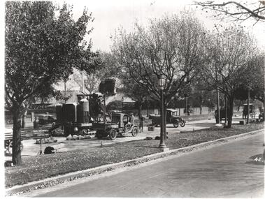
Photograph - Black & White Photograph/s, c1926
Black and white photograph of the construction of the tram track in St Kilda Road, during 1925 or 1926 by the Foundation Construction Ltd, with a concrete mixer tracked vehicle and two aggregate or crushed rock trucks. Photo from the Collection of the Department of Infrastructure now with the Public Records Office - image number H514. Note: this photo is now out of copyright and was not an original VR photograph, but one copied from another source and collected as their Heritage series. See Image 3674i2 and 3674i3 for a digital image of the card photograph at the PRO on 7/1/2019 that this photograph comes from. Further notes from Rod Atkins 11/7/2019: The cement mixer was state of the art machine at the time. "Buddy" in the USA were making them but this one is slightly different and may have been made by a company call AAC in Sheffield U.K. You can just make out the word " ….field" etc … on the water tank . The sign; now this is very interesting. "The Foundation Company" is the Australian company of the one in London.. from The Argus at the time. run by no less than by Herbert Del Cott Ply Ltd. (you can just make that out in the bottom line of the sign.) A rather interesting person in Melbourne society between the wars. His name pops up a lot in The Argus. was not short of a pound either.... Had his "Buick" stolen from Russell Street in 1920. Had some issues with wages on Wellington Street conversion. Looks to have run a electrical business before seeing opportunity with cable tram replacement coming up. In the 1930' lived in Stevenson Street, Kew. Travelled a lot to Europe. (Austria) …..Has Department of Infrastructure copy right stamp on rear and number "H 514" in ink on rear and "2-1"trams, tramways, st kilda rd, trackwork, construction, conversion