Showing 22463 items matching "parks"
-
 Whitehorse Historical Society Inc.
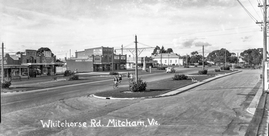
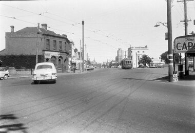
Photograph - Black and white negative - Whitehorse Road Mitcham c. 1949, Harold Ernest Millane, Whitehorse Road Mitcham, Vic. c. 1949, circa. 1949
This image was one of a series taken by Harold Millane in the late 1940's. They were printed onto post cards. Mary Millane, Harold's wife, printed captions on each negative with Indian ink. The series includes a variety of views of Mitcham, Vermont, Nunawading, Park Orchards and Doncaster East. The post cards were sold as souvenirs in the Millane shop on the N-E corner of Station Street and Whitehorse Road, Mitcham (originally the Mitcham Post Office).Clear photograph showing details of shops, vehicles, streetscape, lighting.Celluloid half plate B + W negative.Whitehorse Road Mitcham, Vic. hardy scott, h. s .beckwith, richards drapers, d. g. williamson, r. gracie, s. kelly, cenotaph, mitcham memorial hall -
 Ballarat Tramway Museum
Photograph - Black & White Photograph/s - Geelong 23 at Railway Station, Wal Jack, Jun. 1939
Black and white photo from the Wal Jack album (item 5003) of Geelong tram 23 leaving the railway station with Johnstone park in the background. i1 - scan of print in the album i2 - rear of image i3 - scan of negative at 3200dpi - not exactly the same location given the position of the trees behind. i4 - scan of a print from the Ken Magor collection i5 - scan of rear of print with date 21-6-1939 and Ken Magor number 1805. Yields information about Geelong tram 23Photo of No. 23 at the Geelong Railway Station. Has the Wal Jack copyright stamp on the back.trams, tramways, geelong, railway station, tram 23 -
 Bayside Gallery - Bayside City Council Art & Heritage Collection
Map - print, Melbourne and Metropolitan Board of Works, Interim development order: Brighton, Moorabbin and Sandringham, 1959
The Melbourne and Metropolitan Board of Works (now Melbourne Water) was established in 1891. From that time, as part of their work laying water and sewerage connections, they created detailed plans of houses and other buildings in the Melbourne metropolitan area. In 1956 it acquired powers to construct and maintain highways and bridges, protect and improve the foreshores and create and maintain parks within the metropolitan region. This Interim development order comprises part of the municipalities of Brighton, Moorabbin and Sandringham and was made on 20 October 1959.brighton, moorabbin, sandringham, melbourne and metropolitan board of works, map, town planning, cartographic material, interim development order, bayside -
 Kew Historical Society Inc
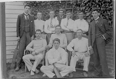
Photograph, First XI, Kew Cricket Club, 1913
The first cricket club in Kew in was formed in 1863, and played its matches in Wellington Street, and then later in O’Shaughnessy’s Paddock. In the early 1870s, a second club was formed and played at Victoria Park. The Kew Cricket Club gained its permanent name in 1888-89. One of the named players in the photograph - Albert Watson - was the son of the local Methodist Minister. The photograph entered the collection within a donation of items by Mrs Joy Ivory, a descendant of the Watson family, and a member of the Society.The photograph, dating from 1911 has local significance as an image of participation in sport and recreation.A monochrome photograph, mounted on card of the Kew Cricket Club's first XI cricket team in 1911. Annotations on the reverse identify three of the players: Standing left with bat: George Twycross; standing right: Albert Clements; Seated third on right: Albert Watson.Presented to Kew Historical by Mrs Ivory (nee Watson) Kew Cricket Club / Standing left with the bat Mr George Twycross / Standing right Mr Bert Clements / Seated third on right Mr Albert Watson / Year 1913kew cricket club (vic), sport - kew - victoria, albert watson, albert clements, george twycross -
 Vision Australia
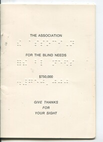
Booklet - Text, The Association for the Blind needs $750,000 - Give Thanks For Your Sight
Overview of the work done by the Association for the Blind and contact details for all those involved in managing the appeal. The 'Sight, Kooyong' appeal aimed to raise $750,000 to provide additional facilities at Kooyong, Oak Park, Geelong, Ballarat, Mildura and Shepparton, expand the George Vowell Day Centre and establish residential facilities at Mt Eliza, expand welfare and rehabilitation services across Victoria, increase work done in the Low Vision Clinic and expand awareness in the prevention of blindness.1 booklet with braille and print on front covernon-fictionassociation for the blind, elizabeth maxwell, neil maxwell, fundraising -
 Melbourne Legacy
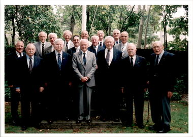
Photograph - Past presidents, Past Presidents 2008, 2008
Photograph of the group of past Presidents in 2008. There is usually a Presidents luncheon every year and a group photo is taken. In 2008 the past presidents were listed on a photocopy of the photo, from left in this photo are; David Kelly, David Grierson, George Woodward, David Millie, Ron Foskett, David Carter, Ray Ward, Alf Argent, Tony Parkes, Tom Butcher, Geoff Swan, Lucky Luscombe, Graham Riches, Colin Bannister, Rob Allison, and Robbie Robertson.A record of the past presidents gathering together each year.Colour photo x 2 of a group of former Legacy Presidents in 2008 and an A4 black and white photocopy with names added, and an A4 colour photocopy.past presidents, presidents lunch -
![Map, [Coornmill land area available for leasing for grazing, Parish of Coornmill]. Circa 1904](/media/collectors/5e461d8021ea67224c82f2a1/items/677cde147f2053f3e5d277c3/item-media/677cdeea7f2053f3e5d27bb4/item-fit-380x285.jpg) Bacchus Marsh & District Historical Society
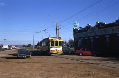
Bacchus Marsh & District Historical SocietyMap, [Coornmill land area available for leasing for grazing, Parish of Coornmill]. Circa 1904
This map shows an area of land north of Bacchus Marsh in the Larderderg State Park area known as the Parish of Coornmill.The map indicates an area of land which was to be made available by public tender for grazing leaseholders. The plan to do this was discussed in the Bacchus Marsh Express newspaper on the 16 July, 1904, page 2, column 7. The area reserved for grazing leases is identified by red lines on the map. The Express described the area available for grazing was 12,000 acres.A single page paper map showing an area of land in the Parish of Corrnmill to be made available for grazing leases. A photo lithographed Lands Department Map. No scale indicated. The map is pasted into a bound volume containing 76 maps or plans in total. High resolution digital image stored on BMDHS computer network. coornmill parish maps, lerderderg state park maps, agriculture bacchus marsh area -
 Ballarat Tramway Museum
Negative - Geelong tram 36 Mercer St, Laurie Gallop, early 1956
Photo shows Geelong tram 36 outbound to North in Mercer St at Ginn St. In the background is a shop selling Franklins Lemon Swish, a four & Twenty Pie shop, Toppa Ice cream, a Coca Cola truck, a Hotel advertising Richmond Lager, three parked buses and a shop advertising hot pies. On the pole is a tram stop with a metal "CARS STOP HERE" sign. On the left-hand side of the photograph a surveyor can be seen at work.Yields information about the Geelong operations toward the closure of the tram system.Black and white Negative - 120 sizetramways, geelong, mercer st, tram 36, tram stops -
 Bendigo Historical Society Inc.
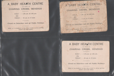
Administrative record - Charing Cross Baby Health Centre Cards
In November 1921 the Bendigo Baby Health Centre was established in rooms at the Town Hall. By Dec. 1925, the council offered two rooms at the Commonwealth Chambers, Charing Cross to be used for the rapidly growing service. In October 1934, council proposed the need for a purpose built Centre and the site in Rosalind Park was chosen in December of that year. The new Centre opened 7/4/1936. Noel Blyth Townsend was born in 1937 and in 1959 married George Victor Rumbold.Charing Cross Baby Health Centre: Three cards Noel Townsend Years: 1937, 1939, 1940 Three cards, each has standard information in print on one side and ink written details on reverse sidecards, noel townsend -
 Bacchus Marsh & District Historical Society
Photograph, Police Barracks Main Street Bacchus Marsh 1883
The Bacchus Marsh Police Barracks shown in this image were located in Main Street on the site of the present day Police Station. The Barracks were constructed around 1857 or 1858. Prior to this the Police were stationed in the Police Paddocks at Maddingley in the area where Maddingley Park is now located. This building was in use by the Police until 1930 when it was replaced by a new building. This later building was in use until the early 2000s but was demolished in 2003 and replaced by a larger Police building.Small sepia unframed photograph on card with gold border framing photograph. Housed in the album, 'Photographs of Bacchus Marsh and District in 1883 by Stevenson and McNicoll'. The image shows the Bacchus Marsh Police Police Barracks and stables in 1883. Two uniformed male police officers wearing helmets can be seen standing on the footpath in front of the building. Next to them on their left stand two boys, one holding a document, possibly a newspaper.. The Barracks is a sandstone building with a chimney on one side; it appears to have a slate roof. Two buildings can be seen behind the main building. A white picket fence with a double gate runs along the front of the complex.On the front: Stevenson & McNicoll. Photo. 108 Elizabeth St. Melbourne. COPIES CAN BE OBTAINED AT ANY TIME. On the back: LIGHT & TRUTH inscribed on a banner surmounted by a representation of the rising sun. Copies of this Portrait can be had at any time by sending the Name and Post Office Money Order or Stamps for the amount of order to STEVENSON & McNICOLL LATE BENSON & STEVENSON, Photographers. 108 Elizabeth Street, MELBOURNE. stevenson and mcnicoll 1883 photographs of bacchus marsh and district, bacchus marsh police station, police stations, police -
 Melbourne Tram Museum
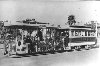
Photograph - Cable tram 306 - Prk St Sth Melb, c1930
Photo of a cable tram set, trailer 306, in Park St South Melbourne with the St Vincent Gardens in the background. The photo is taken after the construction of the Collins St electric line in 1929 as the destination board notes the tram is connecting with Collins St electric trams. The gripman is waiting for the phtograph to be taken, with the Conductor on the platform of the trailer car. In the background are the Gardens and housing of this area. Photo c1930. The South Melbourne cable tram line closed for conversion in 1937.Yields information about the South Melbourne cable tram line and Park St.Black and white print with a plain backtrams, tramways, south melbourne, tram 306, cable trams, park st -
 Ithacan Historical Society
Photograph, WW2 Australian Defence Forces - Allied Aliens, c1942
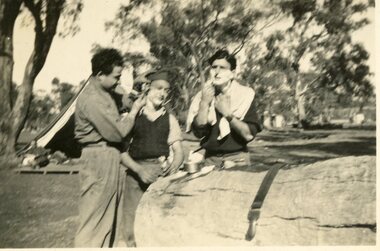
The three soldiers, all from Ithaca, served with the Australian Civilian Military Forces during World War 2. They are pictured at Camp Pell, Royal Park Melbourne where a large military camp was located during World War 2. Naki Raftopoulos is the man being shaved. He migrated as a young boy in the early 1930. Initially the family settled in the Mildura area where other members of the Raftopoulos family were established. Eventually they moved to Melbourne.During the period of the second world war, Ithacans who were unnaturalised were recruited into the Civilian Military Forces as 'Allied Aliens' and served the war effort on the home front. Naturalised Ithacans saw active service. A black and white photograph of three soldiers standing around a fallen tree trunk in a camp. One man is shaving himself while the man in the middle is being shaved. A tent is visible in thew background.army -
 Ballarat Tramway Museum
Slide - 35mm slide/s - set of 6, Noel Simons, 22/05/1971 12:00:00 AM
Set of 6 Kodachrome transparencies taken on 22/5/1971. 1171.1 - Tram 33 at Sebastopol terminus, showing destination of Lydiard St. Nth, with Royal Mail Hotel in the background and three parked cars. Tram has "Twin Lakes" sign on front dash. 1171.2 - as for 1171.1 but taken from other side of tram, has hotel in part of photo. Shows arrangement of tram terminus signs on a pole in the background. 1171.3 - Tram 26 just after arrival at the Lydiard St. terminus, with passengers getting off and driver about to swap ends. Destination has been changed to Sebastopol. Has Lydiard St. shelter in the right edge of the photo. 1171.4 - as for 1171.3 - but with pole turned and looking back along street towards city. Shows the undulating nature of the street. 1171.5 - Tram 26 outbound in Albert St. for Sebastopol, crossing the street near Ophir St. Has a motor cyclist stopped for tram and shows tram stop on the west side of the road. 1171.6 - Tram 26, close up of tram at the Sebastopol terminus with two cars parked along side. Tram has destination of Lydiard St. Nth.1171.1 - "No. 33 at Sebastopol Terminus" and initials "BC" in bottom left hand corner. 1171.2 - "No. 33 at Sebastopol Terminus" and initials "BC" in bottom left hand corner. 1171.3 - "No. 26 at Lydiard St. North terminus" and initials "BC" in bottom left hand corner. 1171.4 - "No. 26 at Lydiard St. North terminus" and initials "BC" in bottom left hand corner. 1171.5 - "No. 26 crossing from left side of Albert St. Sebastopol to right side near Ophir St." and initials "BC" in bottom left hand corner. 1171.6 - No. 26 at Sebastopol Terminus" and initials "BC" in bottom left hand corner. All slides have date stamp of "22 May 1971" in purple ink and Kodak developing date of "Jun 71M7" in red ink. tramways, trams, sebastopol, lydiard st nth, royal mail hotel, tram stops, tram 33, tram 26 -
 Ballarat Tramway Museum
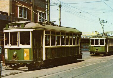
Postcard - Illustration/s, McCarron Bird, MMTB tram postcards
Set of nine of printed illustrations - postcard size of Melbourne and Metropolitan Tramways Board Tramcars produced in 1978. Separate card for each class of tramcar featured, with notes, statistics, MMTB name. Each card also has printers name and date on back. Not a formal postcard, no place for a stamp. 1810.1 - X1 - 465 with 466 in background. Photographed at Footscray station terminus, c1962. 465 has destination of "Ballarat Rd." 1810.2 - Z7 in Victoria Parade, c1975 - has destination of "West Preston - Regent St." and route number "13". 1810.3 - Cable car set (No. 1) - photographed at Preston Workshops 1810.4 - L104 - showing destination of Carnegie and route number 67. 1810.5 - Y469 - showing destination of "Wattle Park - Elgar Road", possibly with Wattle Park in background. 1810.6 - T180 - showing "Special", while on a charter. 1810.7 - W7 1022 - showing destination "West Preston", route 11, freshly painted. 1810.8 - X2676 - freshly painted. 1810.9 - W2511 - fitted with marker lights, freshly painted, showing "City" - route 11. Cards 8 and 9 added 9/3/2018 from Donation of John Ruyg. trams, tramways, melbourne, mmtb, tramcars -
 Ballarat Tramway Museum
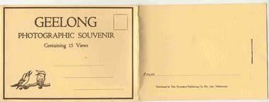
Postcard - Folder set, Valentine & Sons Publishing Co, "Geelong Photographic Souvenir", early 1920's
Shows views of the Geelong CBD and beach area in the 1930's including one tram photo and two other photos of trams in the street and the centre poles which were later removed. Demonstrates production of souvenirs of the era - folded postcards. The photos could also be used for individual postcards.Set of 15 black and white views of Geelong printed on a folded strip, glued within a manila colour cardboard folder, titled "Geelong Photographic Souvenir". Booklet printed with an address area with title and kookaburras and on the rear, an area where the sender could write their name. Produced by The Valentine Publishing Co. Pty Ltd Melbourne. The rear has a slit on the rear cover that allowed the folder to be secured. Pictures are: 1. Panorama of Eastern Beach Geelong 2. Eastern Beach Gardens 3. Eastern Beach 4. Ryrie St with centre poles and a tram in the distance. 5. Botanic Gardens 6. Johnstone Park 7. Gordon Technical College 8. Moorabool St. - with poles in street, single line track and tram in far distance. 9. Eastern Beach and Wharves 10 T and G Building 11 The Fountain, Eastern Beach 12 Town Hall and Post Office 13 Baron bridge - just prior to opening - roadway construction appears to be underway. 14 Malop St with tram (10?) in foreground 15 View of Johnstone Park. Made during 1930's given motor cars in the photo. trams, tramways, geelong, postcards, malop st, town hall, post office, gardens -
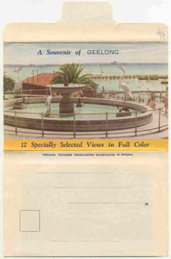 Ballarat Tramway Museum
Postcard - Folder set, Nu-color-vue or Nucolorvue Productions, "A Souvenir of Geelong", 1950's
Set of 12 colour views of Geelong on a folded strip, glued within a colour printed cover, titled "A Souvenir of Geelong", printed on both sides of the strip. Booklet printed with an address area on rear. Produced by Nulcolorvue Productions, Mentone, Victoria. The rear has a slit on the rear cover that allowed the folder to be secured. On the inside of the front cover, has an introduction to Geelong, notes "modern tram and bus routes" Pictures are: 1. Gheringhap St showing Geelong City Hall and Post Office 2. The Barwon River, Geelong 3. T&G Building, Ryrie St - shows tramway overhead 4. Christ Church, Moorabool St 5. Malop St Geelong 6. Art Gallery and Park 7. St Marys Roman Catholic Cathedral 8. The Geelong Post Office with buses in background and a Safety Zone sign 9. Moorabool St Geelong - has overhead and a bar traffic light/ 10. Queens Park Geelong 11. The Waterfront at Geelong. 12. Eastern Beach Swimming Pool. Made during the early 1950's, given motor cars in the photo. trams, tramways, geelong, moorabool st, ryrie st -
 Port Melbourne Historical & Preservation Society
Photograph - Various photos related to John James GILCHRIST, John Gilcrist, 1940s - 1950s
From John Gilcrist via Janet Bolitho13 photos from John GILCHRIST showing his father, John James GILCHRIST, at Station Pier and Princes Pier, a view from the Shrine of Remembrance, Centenary Bridge, and his father and mother, Eileen Mary GILCHRIST at their home at 16 McCormack Street Port Melbourne .01 - Princes Pier, Taroona, Port Hobart .02 - View from Shrine overlooking Albert Park Lake .03 - Between piers .04 - Princes Pier at night .05 - From Station Pier West finger pier .06 - House at 16 McCormack Street. (No. 12 McCormack Street also shown) .07 - Centenary Bridge1949-50 .08 - Outside 16 McCormack Street, showing Singer car. (Nos. 22, 24 & 26 McCormack Street also shown) .09 - John and Eileen Gilcrist in backyard .10 - South side of house at 16 McCormack Street .11 - South side of house at 16 McCormack Street .12 - Photo of Edwards Park .13 - East side of house at 16 McCormack Street Refer also to hand drawn plan of house and outbuildings at catalogue no. 2763piers and wharves - station pier, piers and wharves - princes pier, built environment, transport - roads, mccormack street, john gilchrist, john james gilchrist, mary eileen gilchrist -
 Friends of Ballarat Botanical Gardens History Group
Slide - Colour transparency
... parks ...Thomas Stoddart, bought 12 marble statues during a visit to Carrara in Italy and gave them, together with Sicilian marble pedestals, to the citizens of Ballarat. The statues were unveiled by the Governor of Victoria on Queen Victoria’s birthday, 24 May 1884 and are located throughout the gardens.View of the gardens with the sculpture of Wallace and the statuary pavilion.ballarat botanical gardens, trees, parks, lawns, flowers, pathways, thomas stoddart, marble, statues, carrara, italy, 1884, fernery, 1889, plaque, memorial, mrs w.d. thompson, mbe -
 Warrnambool and District Historical Society Inc.
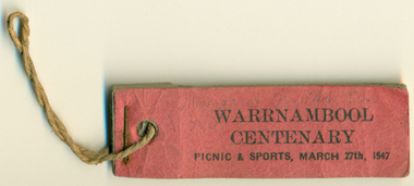
Souvenir - Ticket Book, Warrnambool Centenary Picnic & Sports 1947, 1947
The Centenary of Warrnambool in 1947 drew crowds of 20000. It was generally felt that the celebrations excelled anything that had been seen in the city in the last 100 years. There were numerous activities held over the weekend including an elaborate street parade which was followed by joining the 4500 children at sports and picnic celebrations at the showgrounds. The Warrnambool and District Turf club also held a race meeting to aid the Hospital and raised 740 pounds. It was estimated that 20000 attended the finale bonfire and fireworks in Albert Park. This little booklet of tickets is a tangible link to one of the biggest celebrations ever held in the city.Dark pink cover with three remaining tickets stapled and held with string. On Cover: Warrnambool Centenary. Picnic and Sports March 27th 1947 Margaret P**** in greylead warrnambool, warrnambool centenary, 1947 warrnambool celebrations warrnambool centenary tickets -
 Christ Church Anglican Parish of Warrnambool
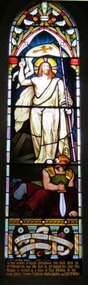
Memorial window: Eliza RUTLEDGE
Eliza Rutledge (1820-1888) was the daughter of Rupert and Jane (nee Newby) Kirk. She married William Rutledge in St James’ Church, Sydney on 18th August, 1840. She and William had five children two sons and five daughters. Recorded accounts tell that Eliza was “beloved for her kindness and hospitality” and that she and William kept open house for all manner of social events and occasions. Eliza died at Farnham Park, Dennington, on 31st August 1888. The marriage of Eliza to William Rutledge, a man of historical importance in the development of Port Fairy, Warrnambool and the western district of Victoria, places her as a person of importance.Her daughter Susan Fleetwood is also memorialised in a window in Christ Church, Warrnambool.Her son, Thomas Forster is memorialised in a tablet near the two windows for Eliza.Stained-glass lancet window, south wall, main nave. A depiction of the risen Jesus.In fond memory of ELIZA RUTLEDGE who was born on / 12th February AD 1820, who died on 31st August AD 1888, this / window is erected as a token of filial affection by her / loving children Thomas F Rutledge, Martha Hamilton and Edith McKellar.rutledge, christ church warrnambool, eliza rutledge, eliza kirk, farnham park -
 Warrnambool and District Historical Society Inc.
33.3 R.P.M. Record (Warrnambool Technical School), H.M.S. Pinafore, 1971
This record was made by a local business existing in the 1960s and early 70s, Warrnambool Recording Enterprises. This business used a local landmark, the Tower Hill State Park, as its logo and label. The recording is of the 1971 production of ‘H.M.S. Pinafore’ by the students of Warrnambool Technical College. This school was established in 1913 in Timor Street and in 1973, as Warrnambool Technical School, was relocated to Caramut Road and re-named Brauer college in 1990. The Timor Street site is now the South West TAFE College. This record is of interest as a memento both of the Warrnambool Technical College’s musical performance in 1971 and of the production of records such as this one by a local business, Warrnambool Recording Enterprises in the early 1970s. This is a 33.3 R.P.M. record with a part-image of a guitar and a yellow label in the centre with black printing and typing. It is in a paper sleeve which is tattered with the bottom section mostly missing. The cover does not appear to belong to the record. Tower Hill HMS Pinafore presented by students of Warrnambool Technical School 1971 Custom Recording by Warrnambool Recording Enterprises P.O. Box 123 Warrnambool Phone 8223warrnambool technical school, warrnambool recording enterprises tower hill label, history of warrnambool, ‘h.m.s. pinafore’ -
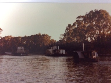 Port of Echuca
Colour negative, coloured photograph and coloured enlargement, 03/04/1984
These photographs and negative show the P. S. Adelaide travelling from Paddlewheel Park up to the Echcua wharf, immediately after being re-launched into the Murray River on 03/04/1984. The P.S.Adelaide had been displayed in the Hopwood Gardens, as a static display since 1960. The P.S Adelaide is the second oldest wooden hulled paddle steamer, still operative, in the world. The P.S Pevensey is leading the way up to the wharf, and an unknown smaller paddle steamer follows behind. This photograph is significant because it shows the P.S Adelaide back in the Murray River after 24 years as a static display in the Hopwood Gardens. The P.S Adelaide is the second oldest wooden hulled paddle steamer, still operative in the world. In July 2016 it celebrated its 150th birthday. These images relate to P000059.3, P000060.3, P000061.3, P000062.2, P000063.3, P000070.2, P000071.Colour negative and two different sized photographs showing three paddle steamers travelling upstream towards the Echcua Wharf. There is a small unidentifiable paddle steamer in the foreground. The P.S Adelaide is sailing between the other two paddle steamers. The P.S Pevensey is in the background. The P.S Murray Queen is in the foreground. All three boats are heading towards the wharf, immediately after the re-launch of the P.S Adelaide from the Hopwood Gardens, back into the Murray River on 03/04/1984.p.s pevensey, p.s adelaide, p.s philadelphia, echcua wharf, p.s murray queen -
 Eltham District Historical Society Inc
Photograph, Birch Cottage, Eltham-Yarra Glen Road, c.1970, 1970
GC advised that when they first arrived in Eltham in the late 1960s, he would enjoy driving out to Yarra Glen. The Eltham-Yarra Glen road was unmade at the time. He passed this residence on the north side of the road. It was totally remote. GC found the juxtaposition of this little cottage with its surburban wire gate out in the remoteness of the landscape intriguing. Since then the road has been reconstructed and diverted away from the cottage which is now owned by Parks Victoria.Digital TIFF file Scan of 35mm Ilford HP4 black and white transparencyIlford HP4birch cottage, christmas hills, early settlers, edwin samuel birch, eltham-yarra glen road, honor mary birch, honor mary williams, john hill, watsons creek -
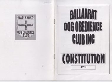 Federation University Historical Collection
Booklet - Booklet - Club Constitution, ZILLES COLLECTION: Ballaarat Dog Obedience Club Constitution, 1995
Zilles Printers was begun by Lewis Zilles in the early 1930s. It was in McKenzie Street Ballarat. His son Jeffrey also became a printer - letterpress, offset and screen printer. The business became Zilles Printers/Graphics and was in Armstrong Street and later Bell Street Ballarat. Booklet for the Ballarat Dog Obedience club Inc. This is the Constitution published in 1995. The Club was established in 1977. It is located in Military Drive. Victoria Park, Ballarat. Classes are held Sundays. It is a non-profit organisation promoting responsible dog ownership.A5 booklet, stapled together. White pages with black print. 26 pages including cover.Name of club. Year of productionzilles printers, ballarat, ballaarat dog obedience club, constitution, responsible dog ownership, victoria park -
 Greensborough Historical Society
Map, Melbourne and Metropolitan Board of Works. Survey Division, MMBW, Yarra 2500 / 12.21. Watsonia North, 1979_02
Melbourne and Metropolitan Board of Works. Yarra 2500 [base map]. 12-22, Parish of Keelbundora 2856, Municipality of Diamond Valley 257. Shows street names, easement sizes, lot numbers, lodged plan numbers, names of prominent features, contour values, creek or river names. Watsonia Railway Station and environs. Prominent streets: Grimshaw Street, William Street and Macorna Street. Includes former Institute of Social Welfare (now Loyola College) Lines Reserve and Binnak Park.MMBW Map in 1:2500 [scale] series. Cream parchment with green tape reinforcing on edges and punched holes on left edge.mmbw, melbourne and metropolitan board of works, shire of diamond valley, watsonia - maps, bundoora - maps -
 Eltham District Historical Society Inc
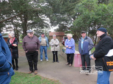
Photograph, Shire of Nillumbik World War One Memorials tour, 10 August 2016, 10 August 2016
As part of a program to acknowledge the Anzac Centenary Nillumbik Shire Council partnered with Yarra Plenty Regional Library to provide a bus tour with commentary of local sites of significance. These included Eltham township, the Shire of Eltham War Memorial at Kangaroo Ground, Christmas Hills, Hurstbridge memorial recreation park and finished at Eltham Library to view the Writing the War exhibtion at Eltham Library Community Gallery. Dennis Ward (right hand side) of "The Friends of Kangaroo Tower" gives a brief presentation about the site. Born Digitalworld war 1, war memorials, shire of nillumbik, kangaroo ground, kangaroo ground memorial, tour, dennis ward -
 Orbost & District Historical Society
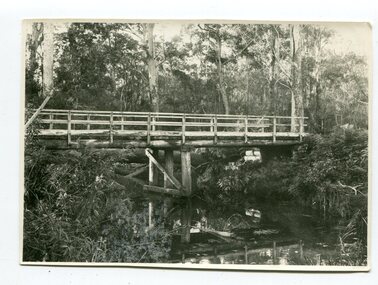
black and white photograph, June 1897
This photograph was taken at what is now the Young’s Creek picnic area which is located on the site of an old sawmill, once owned and operated by L.E. & H. Williams, dating back to the early 1920’s. The mill was eventually sold, dismantled, and the machinery transferred to a sawmill at Cabbage Tree Creek. there are still some items of old sawmill debris. The old steam engine at the edge of the car park is the remains of the mill’s former power plant. This portable steam engine was constructed in Leiston, Suffolk, in England.This is a pictorial record of a popular recreational area in the Orbost district in the late 19th century.A black / white photograph of a wooden bridge over a creek in forest setting. There is a second copy.on back - handwritten "the Young's Creek Bridge June 1897"young's-creek-orbost bridge-young's-creek -
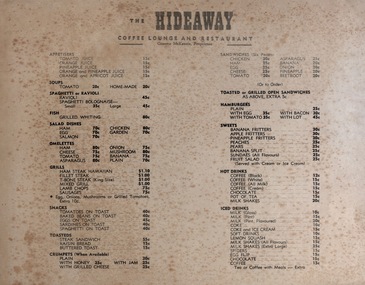 Federation University Historical Collection
Document - Document - Cafe Menu, ZILLES COLLECTION: Menu for "The Hideaway" Coffee Lounge and Restaurant, Ballarat
Zilles Printers was begun by Lewis Zilles in the early 1930s. It was in McKenzie Street Ballarat. His son Jeffrey also became a printer - letterpress, offset and screen printer. The business became Zilles Printers/Graphics and was in Armstrong Street and later Bell Street Ballarat. "The Hideaway" was in Sturt Street Ballarat during 1960s-70s. The propriotor was Graeme McKenzie. He was the manager and swimming teacher at the Eureka Pool until it was taken over by the YMCA. He was also on the committee of the Eureka Stockade Memorial Park. Buff coloured thick card with black printzilles printers, graeme mckenzie, the hideaway, coffee lounge and restaurant, sturt street ballarat, eureka pool, eureka stockade memorial park, swimming teacher