Showing 9613 items
matching water-rates
-
 Eltham District Historical Society Inc
Document, Samantha Westbrooke Pty Ltd et al, 2 Bell Street, Eltham: Cultural Heritage Significance Assessment & Heritage Guidelines for Future Use & Development, 2012
Prepared for Nillumbik Shire Council by Samantha Westbrooke Pty Ltd in association with Peter Mills PhD, Architectural Historian and Roark Muhlen-Schilte, Archaeologist. Covers history of early market gardening in Eltham with the commencement of European settlement in the late 1830s. The site for the village of Eltham was surveyed in 1851 and the Township Plan shows that the property is made up of Lots 7 and 8 which were sold at auction in June 1852 to M. O'Shea. The history of the Bell Street property is closely tied to the West family from the 1860s to 1930s; the earliest rate books for Eltham show William West farming in El;tham in 1864. In the aerly 1930s ownership of the creek side was transferred from the west family to the Fabbro family who shortly afterwards were impaced by the 1934 Diamond Creek flooding. Guido Fabbro relocated the original West home further up the hill and built a new Italianate style modern home in situ. The Fabbro family farmed the property. In 1993/4 Eltham Council acquired the creek-side market garden blocks to the south of 2 Bell Street which was recconceived in 1998 as the Barak Bushland Reserve. The Fabbro house was demolished shortly after and the lots were sold to a developer in 1994. The large steel shed now present on the 2 Bell Street property dates from soon after this sale.26 A4 pages color printcultural heritage significance assessment, peter mills, samantha westbrooke pty ltd, shire of nillumbik, 2 bell street, eltham, market gardening, west family, fabbro family, land use, barak bushland reserve, heritage assessment -
 Glen Eira Historical Society
Article - Rosemont, Kooyong Road, 112A, Caulfield North
Eight items about this property: Handwritten notes from 1870 Caulfield rate book along with list of owners 1870-1890; unsigned and undated. Short history of Rosemont from 1860’s with owners listed up to 1895. Includes description of land and architectural features of house with sketch of pillar. Unsigned and undated with both typed and handwritten information. Unsigned and undated note (original and photocopy) about 112 Kooyong Road and Rosemont’s changing address over time. Photocopy of Andrew Ward’s Heritage Study (two pages) on 112 Kooyong Road (rear) describing significance, history and description of property. Includes photo. Online print without photo of same Heritage Study with handwritten note about brick exterior provided by owner/occupier to compiler Andrew Frederick 2010. Excerpt from Caulfield’s Building Heritage p.47-48 Volume 1 by Dr. Geulah Solomon about Rosemont giving description and history (start of entry on page 46 omitted). Added by Claire Barton date unknown. Notes taken by Andrew Frederick from Caulfield Heritage Vol.1 pages 47-9 re history; and from Sands and McDougall Directories of 1874, 1903, 1911, 1913 and 1923; plus 1913 entry in Vict. P.O Directory. These show house numbers and owners for those periods. Three pages of plans relating to Rosemont covering ground and first floors.rosemont, caulfield north, howitt godfrey dr., kooyong road, blake arthur, grice james, cast iron work, cellars, campbell john a., campbell john archibald, stables, verandahs, king thomas, howitt’s corner, howitt alfred william, farm houses, bakewell john, architectural features, bricks, mcwilliams robert, rosemont estate, mansions, howitt william godfrey dr., arches, balaclava road, coach houses, outbuildings, timber houses, squatters, campbell john, connelly mrs., king florence, slate tiles, ward andrew, chimneys, fireplaces, allen george, warburton james, mirfield professor, hall william sir, hall lady, land subdivision, cellars, embossed leather features, bay windows, house names, victorian style, ceilings, stairs, gardens -
 Eltham District Historical Society Inc
Photograph, Frank Stokes with daughters Dorothy (left) and Beryl (right) at Stokes Orchard, Nyora Road, Eltham, 1944, 1944
Frank Stokes first traveled to the district by train in 1944 to find land with the intention to establish an orchard. By chance he met Arthur Bird of Bird Orchard (bounded by Pitt Street, Eucalyptus Road and Wattle Grove) and they got talking over their common interest. Arthur put Frank up for the night and pointed out the land, part of Crown Allotment 15, Section 5, Parish of Nillumbik (CA15) somewhat diagonally opposite Bird Orchard. Frank bought the land and for the next two years would travel by train from Melbourne to Eltham every weekend establishing Stokes Orchard and building a home for his family, which they eventually moved into in 1946. In the mid 1970s the Shire of Eltham divided the orchard up into numerous rate-able parcel lots, which became affordable for Frank. As a consequence Stokes Orchard was turned into a housing development by Macquarie Builders and marketed as the Stokes Orchard Estate in two stages; Stage 1 encompassing Scarlet Ash Court, Ironbark Close and Peppermint Grove bounded by Nyora and Eucalyptus roads c.1976 and Stage 2 encompassing Stokes Place, Orchard Way, The Crest and The Lookout bound by Nyora and Diosma roads c.1979. The development of Orchard Way, The Crest and The Lookout did not proceed as planned due to the lack of the sewer along Diosma Road and so many of the proposed lots were incorporated into five-acre parcels instead.Representative of the orchard growing areas of ElthamDigital file only - Digitised by EDHS from a scrapbook (containing commercially printed photos of digital scans) on loan from Beryl Bradbury (nee Stokes), daughter of Frank Stokes.1944, beryl bradbury (nee stokes), beryl bradbury (nee stokes) collection, dorothy stokes, eltham, frank stokes, nyora road, stokes orchard -
 Waverley RSL Sub Branch
Shell 40 Cal
The Bofors 40 mm gun, often referred to simply as the Bofors gun, is an anti-aircraft/multi-purpose autocannon designed in the 1930s by the Swedish arms manufacturer AB Bofors. It was one of the most popular medium-weight anti-aircraft systems during World War II, used by most of the western Allies as well as by the Axis powers. The shells were manufactured according to a British design after it was discovered that the Swedish shells had much too sensitive a contact fuse, "which functioned on impact with rain drops". Although the shells could nominally reach out to 11,000 yards (10,000 meters), almost all the shells manufactured had self-destroying tracers that detonated the rounds at a range of 4000-5000 yards (3700-4600 meters.) This helped prevent friendly fire incidents or other collateral damage. In addition to the TNT bursting charge, the shell contained a pellet of powdered magnesium and aluminum as an incendiary. Production of ammunition peaked at 12 million rounds per month in the winter of 1944. Ammunition type Contact fused HE/incendiary fixed shell. AP shells were also available. Projectile weight 1.985 lb 0.80 kg Velocity 2890 feet/s 881 m/s Maximum elevation 90 degrees Range 11,000 yards 10,000 meters Altitude 22,800 feet 6950 meters Rate of fire 120 rounds per minuteCollected by Norman Hall D.J Hall 17455 RAN2 shells (complete) for a Bofors 40mm Anti Aircraft Gun used by the R.A.N.See Imagesbofors 40 mm, anti aircraft gun, shell, r.a.n. bofors gun, world war ii, wwii, norman hall -
 Eltham District Historical Society Inc
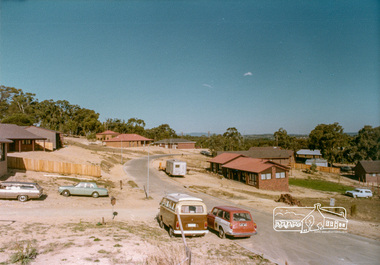
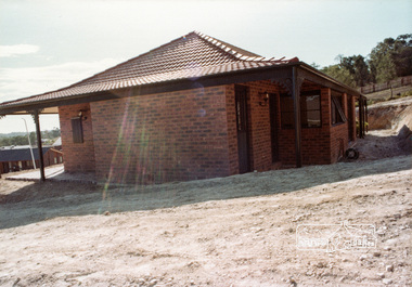
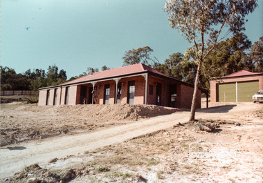
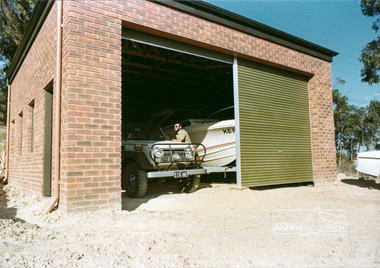
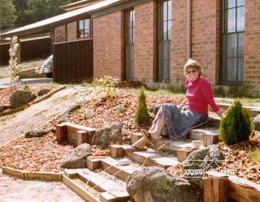
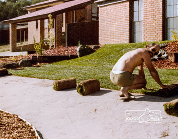
Document, 14 Stokes Place, Eltham: Building plans and contracts, 1979c
14 Stokes Place was the home of Peter and Carla Vermey. The land was purchased in May 1979 and the home built by Peter and Carla Vermey after the developer, Macquarie Builders went bankrupt. Sold October 2017 by Morrison and Kleeman Real Estate. Stokes Place was part of the Stokes Orchard Estate which was developed from the break-up of the the orchard owned by Frank Stokes who lived on the northeast corner of Nyora Road and Eucalyptus Road. His daughter Beryl advised that the Shire had levied a rate assessment on individual parcels of land within the orchard which became unaffordable resulting in its sub-division and sell off. The Stokes Orchard Estate was developed by Macquarie Builders in two stages starting with stage 1 in 1976. Stokes Place was part of Stage 2 in 1979. The Estate was bounded between Nyora Road, Eucalyptus Road, Diosma Road and Stokes Place. The original orchard only just reached the left most portions of Stokes Place and did not go fully up to Diosma, rather to just beyond the extant of Stokes Place. Stokes Place was known within the family as "The Oats" as that is where they grew oats. Frank Stokes moved to Eltham c.1945 after visiting Harold Bird to view his orchard, located diagonally opposite Stokes Orchard from the intersection of Eucalyptus Road, Pitt Street and Nyora Road. It was on Harold Bird's recommendation that Frank purchased the land.The Stokes Orchard Estate collection is typical of housing developments of the late 1970s and 1980s. It was one of the earliest estates in Eltham following the nearby Woodridge Estate development.Digital file30 digital files scanned from documents provided on loan by Peter and Carla Vermeystokes place, eltham, stokes orchard, stokes orchard estate, streets, houses, peter and carla vermey -
 Eltham District Historical Society Inc
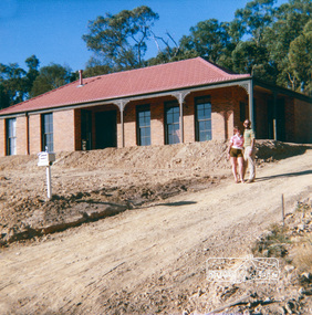
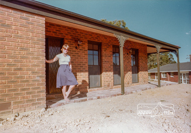
Photograph, 14 Stokes Place, Eltham, April 1980, 1980
14 Stokes Place was the home of Peter and Carla Vermey. The land was purchased in May 1979 and the home built by Peter and Carla Vermey after the developer, Macquarie Builders went bankrupt. Sold October 2017 by Morrison and Kleeman Real Estate. Stokes Place was part of the Stokes Orchard Estate which was developed from the break-up of the the orchard owned by Frank Stokes who lived on the northeast corner of Nyora Road and Eucalyptus Road. His daughter Beryl advised that the Shire had levied a rate assessment on individual parcels of land within the orchard which became unaffordable resulting in its sub-division and sell off. The Stokes Orchard Estate was developed by Macquarie Builders in two stages starting with stage 1 in 1976. Stokes Place was part of Stage 2 in 1979. The Estate was bounded between Nyora Road, Eucalyptus Road, Diosma Road and Stokes Place. The original orchard only just reached the left most portions of Stokes Place and did not go fully up to Diosma, rather to just beyond the extant of Stokes Place. Stokes Place was known within the family as "The Oats" as that is where they grew oats. Frank Stokes moved to Eltham c.1945 after visiting Harold Bird to view his orchard, located diagonally opposite Stokes Orchard from the intersection of Eucalyptus Road, Pitt Street and Nyora Road. It was on Harold Bird's recommendation that Frank purchased the land.The Stokes Orchard Estate collection is typical of housing developments of the late 1970s and 1980s. It was one of the earliest estates in Eltham following the nearby Woodridge Estate development.Digital fileScanned from a print contained in owner's photo album (81 prints in total digitised)stokes place, eltham, stokes orchard, stokes orchard estate, streets, houses, peter and carla vermey -
 Eltham District Historical Society Inc
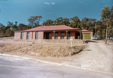
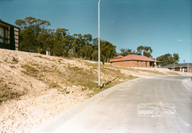
Photograph, Stokes Place, Eltham, April 1980; viewed from near no. 10 looking southeast, 1980
14 Stokes Place was the home of Peter and Carla Vermey. The land was purchased in May 1979 and the home built by Peter and Carla Vermey after the developer, Macquarie Builders went bankrupt. Sold October 2017 by Morrison and Kleeman Real Estate. Stokes Place was part of the Stokes Orchard Estate which was developed from the break-up of the the orchard owned by Frank Stokes who lived on the northeast corner of Nyora Road and Eucalyptus Road. His daughter Beryl advised that the Shire had levied a rate assessment on individual parcels of land within the orchard which became unaffordable resulting in its sub-division and sell off. The Stokes Orchard Estate was developed by Macquarie Builders in two stages starting with stage 1 in 1976. Stokes Place was part of Stage 2 in 1979. The Estate was bounded between Nyora Road, Eucalyptus Road, Diosma Road and Stokes Place. The original orchard only just reached the left most portions of Stokes Place and did not go fully up to Diosma, rather to just beyond the extant of Stokes Place. Stokes Place was known within the family as "The Oats" as that is where they grew oats. Frank Stokes moved to Eltham c.1945 after visiting Harold Bird to view his orchard, located diagonally opposite Stokes Orchard from the intersection of Eucalyptus Road, Pitt Street and Nyora Road. It was on Harold Bird's recommendation that Frank purchased the land.The Stokes Orchard Estate collection is typical of housing developments of the late 1970s and 1980s. It was one of the earliest estates in Eltham following the nearby Woodridge Estate development.Digital fileScanned from a print contained in owner's photo album (81 prints in total digitised)stokes place, eltham, stokes orchard, stokes orchard estate, streets, houses, peter and carla vermey -
 Eltham District Historical Society Inc
Photograph, 14 Stokes Place, Eltham, April 1980, 1980
14 Stokes Place was the home of Peter and Carla Vermey. The land was purchased in May 1979 and the home built by Peter and Carla Vermey after the developer, Macquarie Builders went bankrupt. Sold October 2017 by Morrison and Kleeman Real Estate. Stokes Place was part of the Stokes Orchard Estate which was developed from the break-up of the the orchard owned by Frank Stokes who lived on the northeast corner of Nyora Road and Eucalyptus Road. His daughter Beryl advised that the Shire had levied a rate assessment on individual parcels of land within the orchard which became unaffordable resulting in its sub-division and sell off. The Stokes Orchard Estate was developed by Macquarie Builders in two stages starting with stage 1 in 1976. Stokes Place was part of Stage 2 in 1979. The Estate was bounded between Nyora Road, Eucalyptus Road, Diosma Road and Stokes Place. The original orchard only just reached the left most portions of Stokes Place and did not go fully up to Diosma, rather to just beyond the extant of Stokes Place. Stokes Place was known within the family as "The Oats" as that is where they grew oats. Frank Stokes moved to Eltham c.1945 after visiting Harold Bird to view his orchard, located diagonally opposite Stokes Orchard from the intersection of Eucalyptus Road, Pitt Street and Nyora Road. It was on Harold Bird's recommendation that Frank purchased the land.The Stokes Orchard Estate collection is typical of housing developments of the late 1970s and 1980s. It was one of the earliest estates in Eltham following the nearby Woodridge Estate development.Digital fileScanned from a print contained in owner's photo album (81 prints in total digitised)stokes place, eltham, stokes orchard, stokes orchard estate, streets, houses, peter and carla vermey -
 Eltham District Historical Society Inc
Photograph, 14 Stokes Place, Eltham, 1982, 1980
14 Stokes Place was the home of Peter and Carla Vermey. The land was purchased in May 1979 and the home built by Peter and Carla Vermey after the developer, Macquarie Builders went bankrupt. Sold October 2017 by Morrison and Kleeman Real Estate. Stokes Place was part of the Stokes Orchard Estate which was developed from the break-up of the the orchard owned by Frank Stokes who lived on the northeast corner of Nyora Road and Eucalyptus Road. His daughter Beryl advised that the Shire had levied a rate assessment on individual parcels of land within the orchard which became unaffordable resulting in its sub-division and sell off. The Stokes Orchard Estate was developed by Macquarie Builders in two stages starting with stage 1 in 1976. Stokes Place was part of Stage 2 in 1979. The Estate was bounded between Nyora Road, Eucalyptus Road, Diosma Road and Stokes Place. The original orchard only just reached the left most portions of Stokes Place and did not go fully up to Diosma, rather to just beyond the extant of Stokes Place. Stokes Place was known within the family as "The Oats" as that is where they grew oats. Frank Stokes moved to Eltham c.1945 after visiting Harold Bird to view his orchard, located diagonally opposite Stokes Orchard from the intersection of Eucalyptus Road, Pitt Street and Nyora Road. It was on Harold Bird's recommendation that Frank purchased the land.The Stokes Orchard Estate collection is typical of housing developments of the late 1970s and 1980s. It was one of the earliest estates in Eltham following the nearby Woodridge Estate development.Digital fileScanned from a print contained in owner's photo album (81 prints in total digitised)stokes place, eltham, stokes orchard, stokes orchard estate, streets, houses, peter and carla vermey -
 Eltham District Historical Society Inc
Photograph, 14 Stokes Place, Eltham, October 1983, 1980
14 Stokes Place was the home of Peter and Carla Vermey. The land was purchased in May 1979 and the home built by Peter and Carla Vermey after the developer, Macquarie Builders went bankrupt. Sold October 2017 by Morrison and Kleeman Real Estate. Stokes Place was part of the Stokes Orchard Estate which was developed from the break-up of the the orchard owned by Frank Stokes who lived on the northeast corner of Nyora Road and Eucalyptus Road. His daughter Beryl advised that the Shire had levied a rate assessment on individual parcels of land within the orchard which became unaffordable resulting in its sub-division and sell off. The Stokes Orchard Estate was developed by Macquarie Builders in two stages starting with stage 1 in 1976. Stokes Place was part of Stage 2 in 1979. The Estate was bounded between Nyora Road, Eucalyptus Road, Diosma Road and Stokes Place. The original orchard only just reached the left most portions of Stokes Place and did not go fully up to Diosma, rather to just beyond the extant of Stokes Place. Stokes Place was known within the family as "The Oats" as that is where they grew oats. Frank Stokes moved to Eltham c.1945 after visiting Harold Bird to view his orchard, located diagonally opposite Stokes Orchard from the intersection of Eucalyptus Road, Pitt Street and Nyora Road. It was on Harold Bird's recommendation that Frank purchased the land.The Stokes Orchard Estate collection is typical of housing developments of the late 1970s and 1980s. It was one of the earliest estates in Eltham following the nearby Woodridge Estate development.Digital fileScanned from a print contained in owner's photo album (81 prints in total digitised)stokes place, eltham, stokes orchard, stokes orchard estate, streets, houses, peter and carla vermey -
Glen Eira Historical Society
Book - GLEN EIRA GUIDE
... Rates ...This file contains one item: 1/A copy of the 1999 edition of the Glen Eira guide. This magazine aims to provide readers with useful information for living and working within the City of Glen Eira. It is divided into five principal sections. The first section, titled Glen Eira City Council Information, provides information pertaining to the local government. It includes information about Council meetings, the names and contact details of the six members of the Council, information about services offered by the Glen Eira Service Centre, the contact details for particular services offered by the Glen Eira City Council, information about rates and valuations, information about the building permit application process, information about waste management, and federal and state electoral maps. The second section, titled Council and Community Resource Guide, consists of a list of the various local community facilities and organizations. The third section, titled City of Glen Eira Safe Food Guide, consists of a list of food venues nominated by the Glen Eira City Council Environmental Health Services Department for their commendable level of hygiene. The fourth section, titled City of Glen Eira Business Development Unit, provides information about the eponymous local government department, which is aimed at providing aid to local businesses. The fifth and final section, titled ‘Think Local, BUY LOCAL’ Guide, consists of a list of local businesses, grouped according to industry, to try and encourage the support thereof.glen eira, city of glen eira, glen eira city council, local government, local officials and employees, kennedy norman cr, mayors, public utilities, community services, local government departments, rates, local government, building permits, waste disposal, community groups, cultural structures and establishments, law and order, libraries, education, educational and research establishments, religious groups, clubs and associations, community centres, food, restaurants, businesses -
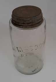 Flagstaff Hill Maritime Museum and Village
Container - Fruit Preserving Jar, John Landis Mason, 1858-1910
The Masons patent of Nov 30th, 1858 phrase was originally embossed on countless glass fruit jars and canning jars, most ranging in age from circa 1858 to the mid-1910s. John Landis Mason was awarded patent No 22186, issued on November 30, 1858, by the U.S. Patent & Trademark Office it was termed an "Improvement in screw-neck bottles", for his invention concerning the process of creating a threaded screw-type closure on bottles and jars. Similar screw-threading had been done before on some bottles, but the process of forming the upper lip area of the container so that it was smooth, even, and sturdy enough for a lid of standard size to be screwed thereon was difficult and expensive to do properly, often with unsatisfactory results. His improvement revolutionized home canning in the United States and many other countries. In any case, throughout the next 60-odd years, production of jars with the Nov. 30, 1858 embossing continued at a high rate, with untold tens of millions being produced. The phrase was soon considered an important marketing device, adding to the perception of quality and reliability of the container to the average consumer. This perception continued to at least 1879 21 years after the patent was issued, nearly every glass bottle factory was likely producing their version. The 1880s and 1890s likely saw the peak of popularity of these jars. A considerable percentage have a mold number or letter on the base, a means of identifying the particular mold in use at the factory.An early item used in most kitchens by women who preserved fruit and vegetables before the arrival of refrigeration giving a snapshot into the domestic lives of families during the late 19th to early 20th century's and how they preserved food for later use without refrigeration. Preserving jar, glass, with metal screw top lid. Glass has side seams, impurities and slightly concave base. It has been hand blown into a mould. Inscription is moulded into glass. Moulded into glass: MASON'S / PATENT / NOV 30TH / 1838"warrnambool, flagstaff-hill, flagstaff-hill-maritime-museum, maritime-museum, shipwreck-coast, flagstaff-hill-maritime-village, food preserving, mason jar, john landis mason, domestic container, glass jar, fruit & vegetable jar, domestic jar, food preparation, handmade glass, blown glass -
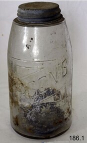 Flagstaff Hill Maritime Museum and Village
Container - Fruit Preserving Jar, John Landis Mason, 1858-1910
The Masons patent of Nov 30th, 1858 phrase was originally embossed on countless glass fruit jars and canning jars, most ranging in age from circa 1858 to the mid-1910s. John Landis Mason was awarded patent No 22186, issued on November 30, 1858, by the U.S. Patent & Trademark Office it was termed an "Improvement in screw-neck bottles", for his invention concerning the process of creating a threaded screw-type closure on bottles and jars. Similar screw-threading had been done before on some bottles, but the process of forming the upper lip area of the container so that it was smooth, even, and sturdy enough for a lid of standard size to be screwed thereon was difficult and expensive to do properly, often with unsatisfactory results. His improvement revolutionized home canning in the United States and many other countries. In any case, throughout the next 60-odd years, production of jars with the Nov. 30, 1858 embossing continued at a high rate, with untold tens of millions being produced. The phrase was soon considered an important marketing device, adding to the perception of quality and reliability of the container to the average consumer. This perception continued to at least 1879 21 years after the patent was issued, nearly every glass bottle factory was likely producing their version. The 1880s and 1890s likely saw the peak of popularity of these jars. A considerable percentage have a mold number or letter on the base, a means of identifying the particular mold in use at the factory.An early item used in most kitchens by women who preserved fruit and vegetables before the arrival of refrigeration giving a snapshot into the domestic lives of families during the late 19th to early 20th century's and how they preserved food for later use without refrigeration. Preserving glass jar. Glass lip with metal screw top lid. Inscription pressed into glass."Mason's Patent Nov 30th 1858"warrnambool, flagstaff-hill, flagstaff-hill-maritime-museum, maritime-museum, shipwreck-coast, flagstaff-hill-maritime-village, food preserving, mason jar, john landis mason, domestic container, glass jar, fruit & vegetable jar, food storage, preserving jar -
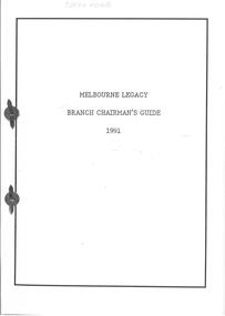 Melbourne Legacy
Document, Branch Chairman's Guide 1991, 1991
A guide for Chairmen of Melbourne Legacy. This copy was owned by Graham Riches. The guide contains: Section A Operations Council and Branches : The Relationship Operations Council Section B Group, Liaison Committee and Groups : The Relationship Group Liaison Committee Section C Internal Changes of Communication and Sources of Information for the Legatee Section D An outline of responsibilities and procedural guidelines for branch chairmen Section E Financial Authority of Branches Section F Guidelines for the Format and Content of Branch Minutes Section G Selection and Appointment of Branch Chairmen Section H Enrolment, Contact and Reporting Procedures Section I Procedure and Notes for Proposers of Prospective Members Section J Duty Legatee Scheme Section K Education (including Sir John Gellibrand Memorial Scholarship and the Macrae Trust) Section L Section M Welfare Section N Pensions, Benefits and Allowances Section O Widows' Committee and Widows' Clubs Section P Widows' Clubs Rules Section Q Current Rates of Social Security and Repatriation Pensions Section R Recommended List of Contractors Available for Home Maintenance (including a list of contractors that can provide services to Widows, such as plumbers, bricklayers, electricians and blind supplies and repairs) 31 yellow pages - not scanned due to it being names and addresses and phone numbers. Section S Administration Instructions An Organisation Chart of Legacy and A Table of Organisation of StaffA living document that was regularly updated for the Chairman of Melbourne Legacy to use in his duties.A4 pages x 64 bound together with split pins.L/GPA Riches in pencil on top edge.regulations, rules, objectives -
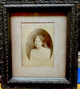 Kew Historical Society Inc
Photograph, Portrait of Winifred Noble, c.1910
One of five group and individual portraits of the Noble family of Kew, two in the rear garden of what is presumed to be ‘Charnwood’, in Station Street, Coburg. The photographs date from the period c.1890-1914. One of the larger framed photographs is a portrait of the entire family group, while another is of two of the children, Frederick and Winifred. The father, Frederick William Noble was a businessman, and, at one period Secretary of the Victorian Creamery & Butter Company in South Melbourne. Later he was to manage J. Bartram & Co., Ice & Cold Storage Department in Flinders Lane. By 1906, the Noble family had moved to Kew, living for almost 20 years at 100 Walpole Street before relocating to 26 Molesworth Street in the mid 1920s. The five photographs in the collection reveal details of family life and social values as expressed through attire. The family is formally costumed in a manner indicative of their social status. Mrs Noble, in one of the large framed portraits, is dressed in a sombre manner in a long, dark-coloured long-sleeved, high-necked gown. It is difficult to know whether she is dressed in mourning wear in this black and white photograph. It was not uncommon for a woman to regularly wear mourning attire due to the high mortality rate in the Victorian era. This situation was compounded for women due to the size of extended families. A woman might rarely be out of mourning due to the death of a parent, a sibling, a husband, a child or a near relative. The portraits of the Noble family children, particularly Frederick and Winifred, show the elaborateness of formal attire worn by the children of wealthy families during the late Victorian era. Winifred is dressed in a long cotton dress and a broad-rimmed hat; both liberally covered in lace. Winifred and Frederick’s lace collars extend to their shoulders. Winifred’s diaries, covering the period 1908-50, are now in the collection of the State Library of Victoria. The most detailed of the diaries is from 1914, just before the outbreak of World War 1, and includes ‘Accounts of my Dancing Evenings - Season 1914’. The diaries were the inspiration for an art exhibition by Jim Pavlidis in 2014. One of the family’s two sons, Frederick, was to work at The Age newspaper for 50 years. His obituary records that “He was regarded as the epitome of accuracy and a fount of knowledge on many subjects, but especially cricket, the Royal Melbourne Show and Gilbert & Sullivan”. With Robert Morgan he compiled Speed the Plough, a history of the Royal Agricultural Society of Victoria and its role in developing agriculture in Victoria.Framed photographic half portrait of Winifred Noble in the original carved wooden frame. Winifred lived at 'Avalon' in Molesworth Street, Kew.Handwritten label on rear "Winifred Noble c 1910-12"noble family, winifred noble, photographic portrait, kew -
 Kew Historical Society Inc
Photograph - Verandah of 'Wimba', 235 Cotham Road, John T Collins, 1979
Although probably built some time earlier, the first mention in the Rate Books of the property later known as 'Wimba Lodge' appears in the entry for 1870 when the property, owned by John Sharpe Denbigh, a civil servant, was given an N.A.V. of £72. Denbigh did however occupy a house in Cotham Road in 1863, and it is possible that was the same premises'. The house was occupied by Sharp until at least May 1876 when the 'family residence ... was auctioned' to Carlington George Edmund Marston, a chemist of Smith Street, Collingwood. At the time of the auction the house was described thus: The residence and grounds of the late J.S. Dendigh, situate in the most elevated part of Cotham Road Kew. The grounds comprise an area of 4a Or 29p or thereabouts, and have a frontage to Cotham-road of 4 chains. The house has two large rooms in front, with 6ft hall built of brick, bay and side windows (plate glass), four rooms of wood behind with slate roofs, bathroom and closets, detached kitchen and servant's room, large shed with washing boiler, pantry and cellar under, brick and cement tank, and the Yan Yean laid onto house and grounds, cowshed, pigstye, &c, the whole securely fenced. First class orchard and flower garden. The paddocks laid with English grasses and drained... .' (Sanderson P. Kew Conservation Study Vol 2)'Wimba' is a single storeyed rendered house. The front entrance is flanked by two polygonal bay windows, and a verandah with a concave corrugated iron roof returns around three facades, and accentuates the projections of the windows. The solid render parapet is very ornate and tall for the date of construction. It has panels of decoration along it and is surmounted by a number of render urns. (Sanderson P. Kew Conservation Study Vol 2)Reverse: "JOHN COLLINS / 11 Anderson Road / Hawthorn East, 3123 / Film 395 Exposure 15A / Kew / Wimba / Front verandah from east / 7-4-79wimba lodge, 235 cotham road -- kew (vic.), john s denbigh, carlington george edmund marston -
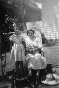 Surrey Hills Historical Society Collection
Digital photo, George L Coop, Winifred Alice Coop and her daughter Alison, c1950, c1950
The photo was taken at 688 Whitehorse Road, Mont Albert. It is of Winifred Alice Coop (nee Trewartha), known as Alice, and her daughter Alison, b1945. This was the home of 3 generations of the Coop family: 1. Josephine and George Frank Coop (noted in Box Hill Rate Books for 1947-1954). 2. George Burton Coop (1906-1960) and his family. He was Assistant Chief Architect of Victoria in the Public Works Department (P.W.D.) George Burton Coop was born in c1906 in Williamstown, the son of Josephine Vistarini and George Frank Coop. He married Winifred Alice Trewartha in 1936 and they are listed in the electoral rolls at 688 Whitehorse Road in 1937. George died 3/4/1960, aged 54 years at Mont Albert; Alice died in 1980. 3. George Burton and Alice Coop had 2 children: George Lister Coop - born St Georges Hospital, 8/10/1937 Alison - born c1945. The donor George Lister Coop informed that he initially attended Chatham State School because his first home was the Spanish Mission style flats at 346 Whitehorse Road, opposite Brenbeal Street, Balwyn. When his grandparents died, the family moved to 688 Whitehorse Road and he then attended Mont Albert Central School. Alison being younger did not go to Chatham Primary. A black & white photo of a woman seated in a cane chair with her daughter standing adjacent to her and standing on a small child's chair. The woman's sun hat is lying beside her on the grass. Both faces are partly shaded by an adjacent bush.alison coop, (mrs) winifred alice coop, whitehorse road, surrey hills, children, clothing and dress, george lister coop -
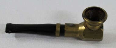 Wodonga & District Historical Society Inc
Functional object - Haeusler Collection Tobacco Pipe c. Mid-Century
The Wodonga Historical Society Haeusler Collection provides invaluable insight into life in late nineteenth and early twentieth century north east Victoria. The collection comprises manuscripts, personal artefacts used by the Haeusler family on their farm in Wodonga, and a set of glass negatives which offer a unique visual snapshot of the domestic and social lives of the Haeusler family and local Wodonga community. The Haeusler family migrated from Prussia (Germany) to South Australia in the 1840s and 1850s, before purchasing 100 acres of Crown Land made available under the Victorian Lands Act 1862 (also known as ‘Duffy’s Land Act’) in 1866 in what is now Wodonga West. The Haeusler family were one of several German families to migrate from South Australia to Wodonga in the 1860s. This tobacco pipe is one of the many objects in the Haeusler Collection that provides insight into life in early to mid-twentieth century Wodonga, and Australia more broadly. Smoking in the first half of the twentieth century was incredibly common in Australia and other western countries. In 1945, more than three out of every four men and one in every four women were regular smokers. While rates of smoking decreased over the next two decades due to observations and research regarding the links between smoking and illness, an increase in tobacco use was documented after the advent of television as people were bombarded with advertisements for cigarettes. This item has well documented provenance and a known owner. It forms part of a significant and representative historical collection which reflects the local history of Wodonga. It contributes to our understanding of domestic and family life in early twentieth century Wodonga, as well as providing interpretative capacity for themes including local history, social history, and women’s history. A tobacco pipe with brass coloured fitting and black stem.tobacco, smoking, pipe, tobacco pipe, haeusler, haeusler collection, wodonga -
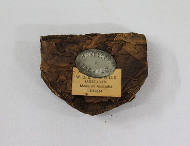 Wodonga & District Historical Society Inc
Functional object - Haeusler Collection Havelock Tobacco c. Early-Mid Twentieth Century, W.D. Wills (Aust.) LTD
The Wodonga Historical Society Haeusler Collection provides invaluable insight into life in late nineteenth and early twentieth century north east Victoria. The collection comprises manuscripts, personal artefacts used by the Haeusler family on their farm in Wodonga, and a set of glass negatives which offer a unique visual snapshot of the domestic and social lives of the Haeusler family and local Wodonga community. The Haeusler family migrated from Prussia (Germany) to South Australia in the 1840s and 1850s, before purchasing 100 acres of Crown Land made available under the Victorian Lands Act 1862 (also known as ‘Duffy’s Land Act’) in 1866 in what is now Wodonga West. The Haeusler family were one of several German families to migrate from South Australia to Wodonga in the 1860s. This tobacco is one of the many objects in the Haeusler Collection that provides insight into life in early to mid-twentieth century Wodonga, and Australia more broadly. Smoking in the first half of the twentieth century was incredibly common in Australia and other western countries. In 1945, more than three out of every four men and one in every four women were regular smokers. While rates of smoking decreased over the next two decades due to observations and research regarding the links between smoking and illness, an increase in tobacco use was documented after the advent of television as people were bombarded with advertisements for cigarettes.This item has well documented provenance and a known owner. It forms part of a significant and representative historical collection which reflects the local history of Wodonga. It contributes to our understanding of domestic and family life in early twentieth century Wodonga, as well as providing interpretative capacity for themes including local history and social history. Lump of tobacco with Havelock Tobacco makers mark on tin insert, with manufacture details on paper"HAVELOCK/TOBACCO" and "J D & (unintelligible) WILLS (AUST.) LTD./Made in Australia/D10114".tobacco, smoking, social history, wodonga, haeusler, haeusler collection -
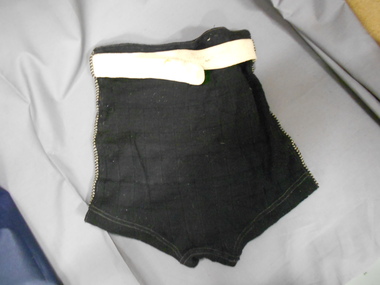 Bendigo Historical Society Inc.
Clothing - MEN'S BLACK WOOLLEN SWIMMING TRUNKS, 3/10/1943
Donated by the great niece of Richard Harry Adams Flight Sergeant Richard Harry Adams, Date of birth 6/2/1922. Place of birth, Brighton Victoria. Brighton State School and Hampton High School. Completed Merit Certificate on 18.12.1936. Enrolled in architectural draughtsman course at Melbourne Technical College May 1938 - May 1940. Occupation in civil life Architectural Draughtsman, applied for RAAF air crew 30.4.1940. Listed sports and games: running swimming, tennis, shooting, bicycle riding, cricket, camping, 8 years' scouting experience and a member of the YMCA. Enlisted 21.6.1941. Conflict/operation: 2nd World War,1939-1945, Height 5'11'', Weight 10 stone 5 lbs. NoK: Father Albert Ward Adams, Rate collector. Place of enlistment, Melbourne. Service No. 409012. Embarked at Sydney 2.11.1941. Service RAAF No. 1449 Flight (RAF). Date of death, 3.10.1943. Place of death Scilly Islands, Cornwall, UK. Aircraft: Hurricane WL BD 729 - Single-engine, single-seat monoplane fighters/fighter bombers. Casuality notification for ''P'' file. Name:409012 F/Sgt. ADAMS, R, H. Att. RAF U.K. Nature of casualty: Missing believed, killed air.ops from UK. Casualty Report No. 280. Date 3 October 1943. C.D. 155/43 ZMen's black woollen swimming trunks. Wide ribbed horizontal pattern. Front skirt panel over trunks. Decorative double line of black and white zig zag seams forming belt keeper loops at waist. Embroidered patch on lower front of LHS with a picture of a sailing yacht. White cotton woven belt with silver coloured clip fastener.costume, male, swimming trunks