Showing 14338 items
matching property
-
 Eltham District Historical Society Inc
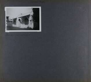
Photograph, Belle Vue, Livingstone Road, Eltham, c.1960, 1960c
Photo taken at time of ownership by Eric Staff. Originally purchased by pioneer Eltham farmer Henry Stooke, Belle Vue farm comprised about 56 ha (140 acres) extending northerly from the northern boundary of Holloway’s 1851 Little Eltham subdivision. On the present day map the southern boundary was just north of Elsa Court and Grove Street. The western boundary was the Diamond Creek and extended northerly to Main Road where it turns easterly towards Research. It was traversed by the main road to Kangaroo Ground and beyond and from 1912 by the railway to Hurstbridge. From 1895 the farm was owned by William Williams and his wife Mary Ann. In 1914-1915 they built a new house now known as “Belle Vue”. They sold the land in 1920 and residential subdivision began soon after that. “Belle Vue” remains today on a large residential lot in Livingstone Road. The house and many old trees on the site have been subject to a heritage overlay under the Nillumbik Planning Scheme. Despite that overlay, most of the heritage trees were removed during sub-division and development of the property.Digital file only from scan of copy on loan to EDHSbelle vue, eltham, eric staff, houses, livingstone road, staff family -
 Eltham District Historical Society Inc
Folder, Shire of Eltham Living and Learning Centre, 1996
Contents: 1. Hand drawn schematic record of site buildings as of 1975 compiled by Harry Gilham, Shire of Eltham Historical Society 2. History compiled on the ocassion of the Eltham Living and Learning Centre's 21st birthday in 1996. Includes historical notes about the property, origins of the Living and Learning Centre at Eltham which started in 1975. List of associate groups, friends of the creek, friends of the centre, playhouse, list of co-ordinators 3. Enrolment Day Cake recipe 4. Poem - "Who'd be a co-ordinator" by unknown 5. Traditions and Memories by Margaret Johnson, Program Co-ordinator for 10 years 6. Reminiscences by Linda Kirkwright, Admin Assistant 7. In the beginning there was a small cottage ... by Joanne Osborne, Assistant Co-ordinator 1977-1980 8. Newsclippings - Living and Learning Centre in Council Centre, Diamond Valley New, 2 Apr 1975; 'Rub-A-Dub" unknown publication; and miscellaneous advertisements 9. Copy of certifcate of title when transferred to the Shire of Eltham in 1975 10. Copy of 1992 Shire of Eltham Heritage Study, pages 930-936 with notations 48 A4 pages photocopies HG Booklets 22 and 47, 64eltham living and learning centre, enrolment day cake, harry gilham collection, heritage study, history, joanne osborne, linda kirkwright, margaret johnson, poem, recipe, reminiscences, who'd be a co-ordinator -
 Federation University Historical Collection
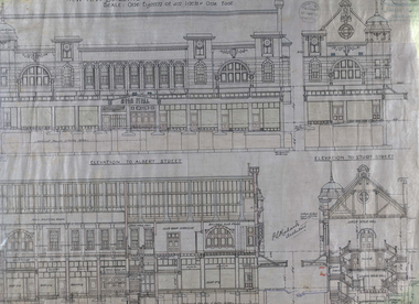
Plan - Architectural Plans, Australian Natives' Association Ballarat Branch No 4 Architectural Plans
Percy Richards taught Architecture and Building Construction at The Ballarat Art School - a division of Ballarat School of Mines from 1918-1921. He was responsible for the design of a number of buildings in the district. This item is the "Specification of work required to be done and materiaals required for construction of the new A.N.A. Building at the corner of Sturt, Albert and Lewis Streets, Ballarat. Prepared by and to the satisfaction of P.S. Richards, A.R.V.I.A. Architect and subject to the General Conditions of Contract." "BALLARAT CITY A.N.A. BALLARAT, Wednesday — The Ballarat City branch, A.N.A., which was formed nearly 50 years ago, ranks fourth on the association records, but several of the members were prominent in establishing the association in Melbourne a year or two earlier. On the past half-year's operations the total funds increased by £1558/18/3 to £29.389/11/11. The membership now totals 949. The committee recommended that as the property at the corner of Sturt and Albert Streets, which had been intended as the site of a new hall, had been sold, steps should he taken to remodel the present hall, and bring It up to date. The report was adopted." (The Herald, 18 June 1924)Fourteen detailed drawings showing the specifications for each section of the new A.N.A. building for Ballarat. A 24 page document submitted to the Public Health Department, Victoria, received 15 January 1918 and a 3 page document related to Reinforced Concrete Particulars. All contained in a labelled black metal cylinder.A.N.A.4. PLANS painted on side and lid. Signature of P.S. Richards.ana, australian natives' association, architecture, percy richards, building specifications, ballarat, technical art school ballarat, materials, construction, p.s. richards, percival selwyn richards -
 Flagstaff Hill Maritime Museum and Village
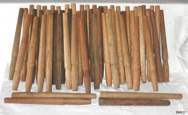
Equipment - Belaying Pins, Late 19th Century
The pins in this collection vary in the timber used and the design. They were found in a warehouse beside Crown Casino in Melbourne, located along the Yarra River, close to the sailing ship "Polly Woodside" and not far from the docks of Port Melbourne. Some of the pins have the mark of a 'Broad Arrow' with 'D ↑ D, which signifies that they were the property of the Australian Government's Department of Defence. Belaying pins are essential equipment on a traditional sailing ship of the 19th and early 20th centuries. They are usually made of wood but some are metal. A belaying pin is used to secure the running ropes of the rigging to the ship's rails using holes drilled onto the rails for that purpose. The belaying pins are inserted into holes in the ship’s rail, drilled for that purpose. When the sail has been raised, the ropes are wrapped around the upper and lower sections of the pins in a figure-eight pattern. The shapes of these belaying pins taper from the rounded end of the handle inwards towards the bottom, which allows them to have a firm fit into the holes in the rails. The rigging rope is wound around the pins in such a way that a tug on the pin's handle pulls it out of the hole and quickly frees the rope and the sail.These belaying pins are significant for their association with sailing vessels, particularly vessels of the late 19th and early 20th centuries. They are also significant for their association with the Port of Melbourne where sailing ships docked to and from the Port of Melbourne. Some of the pins have additional significance for being connected with the Australian Government's Department of Defence.Belaying pin, wooden, simple design, wooden shaft with a wider rounded end on top third, tapering to the centre third, which is wider than a lower third. The bottom has a blunt base. Some of the pins have the three sections divided by a line around their circumferences. This collection of fifty-seven pins of varying shapes, colours and timber. Some of the pins are stained with colour, and some have been left natural Stored in a wooden crate. Some have inscriptions.Marks: (Government Defence Department Broad Arrow) "D ↑ D"sailiing equipment, nautical equipment, rigging, yards, flagstaff hill, maritime museum, maritime village, belaying pin, broad arrow, australian government, australian department of defence, sailing ship, sail -
 Warrnambool and District Historical Society Inc.
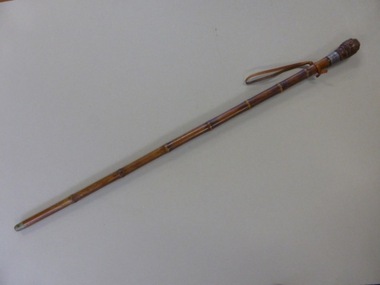
Walking Stick, Mr Bendall Walking & Measuring Stick, c.1920
This walking stick, which is also a horse measurer, belonged to Atwell George Bendall, the well-known racing man, judge and handicapper in the Western District early in the 20th century. Born in the Caramut district, he was the manager of the ‘Green Hills’ estate at Winslow, a property owned by his father who also operated a livery and coach service at Caramut. When his father died Bendall carried on the family business until the end of the 19th century when he went to live in Warrnambool. A lover of horses, Bendall was an amateur rider of note and an owner of several racehorses. He also took a keen interest in coursing and owned and bred many successful dogs. In Warrnambool he took an interest in trotting and owned several trotters. For the last sixteen years of his life Atwell Bendall was a handicapper for most of the Western District race clubs and his keen judgment and knowledge of horses were greatly admired and appreciated. He was also a judge at agricultural shows and other horse events and this is probably where he was made use of this horse-measuring walking stick. He died in 1922. This is a most significant item as it belonged to the prominent early 20th century horse racing identity in the Western District – Atwell Bendall. It is also of general historical interest as an ingenious object – a walking stick doubling as a horse measurer. This is a mottled brown-coloured wooden walking stick, slightly tapered and with seven segments. It has a wooden knob at the top curved and indented in an acorn shape. The knob has silver coloured nails or tacks driven into the raised sections. The knob lifts out and is actually a wooden ruler with silver casing at the top of the ruler. Also at the top of the ruler, at a right angle to the ruler, is a lift-out metal piece which has a spirit level at the top end and this metal piece is used to rest on the horse to estimate its measurement in hands. There is a leather strap near the top of the walking stick for attachment to the wrist and a gold metal cap at the bottom of the stick. A silver band near the top of the stick has an inscription. ‘A G. Bendall Warrnambool’ atwell bendall, history of horse racing in the western district, history of warrnambool -
 Eltham District Historical Society Inc
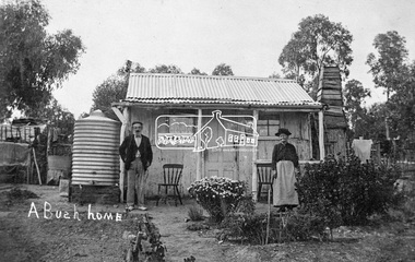
Photograph, Tom Prior, A Bush Home - Research, Vic, c.1895
A slab hut situated in Research, Victoria. An elderly man and woman stand in front of their small bark slab home with bark chimney. It has a tin roof and tin water tank to the side. A small garden is situated at the front. Reproduced on pp 38-39 of 'Pioneers & Painters: One Hundred years of Eltham and it's Shire" (1971) Article in "Australian Family Tree Connections" February 2000 by B. J. Parkinson claims that the people in this photo are "Jonas and Christina Jane (Gregg) PRIOR in front of their home at Ferny Hill, near Eltham, Victoria, 1877". Photocopy of photo also attached to 14 online family trees for the Prior family on Ancestry.com without the words "A Bush Home". References found to Prior in historical newspapers and the property "Ferny Hill". Jonas was a convict from Kent, England. He arrived in Hobart in 1821 aged 19 years. He married Christina Gregg in Hobart about 1834 and had 11 children. They came to Victoria about 1846. He died at Ferny Hill, near Research, Eltham in 1878 aged 74 years and was buried at Melbourne General Cemetery. His occupation was gardener.This photo forms part of a collection of photographs gathered by the Shire of Eltham for their centenary project book,"Pioneers and Painters: 100 years of the Shire of Eltham" by Alan Marshall (1971). The collection of over 500 images is held in partnership between Eltham District Historical Society and Yarra Plenty Regional Library (Eltham Library) and is now formally known as the 'The Shire of Eltham Pioneers Photograph Collection.' It is significant in being the first community sourced collection representing the places and people of the Shire's first one hundred years.Digital image 4 x 5 inch B&W Neg Print 20 x 25 cmshire of eltham pioneers photograph collection, research (vic.), ferny hill, jonas prior, christina prior, hut, prior, convict, pioneers and painters -
 Glen Eira Historical Society
Album - Album page, Cromarty, Sandham Street, Circa 1972
This photograph is part of the Caulfield Historical Album 1972. This album was created as part of a project from approximately 1966-1972 by the Caulfield Historical Society to assist in identifying buildings worthy of preservation. This album is related to a Survey the Caulfield Historical Society developed in collaboration with the National Trust of Australia Victoria and Caulfield City Council to identify historic buildings within the City of Caulfield that warranted the protection of a National Trust Classification. Photographers Jenny O’Donnell and Trevor Hart, members of Caulfield Historical Society. Some photographs are older and from unknown sources. All photographs are black and white except where stated. From Victorian Heritage Database citation for HO61 Presentation Convent, 28 Sandham Street Elsternwick https://vhd.heritagecouncil.vic.gov.au/places/35476 (as at 1/11/2020) The "Presentation Convent" is locally significant as a substantial late Victorian villa residence in Elsternwick and for its more recent role in the educational and spiritual lives of the community. https://vhd.heritagecouncil.vic.gov.au/places/65716 (as at 21/08/2021) National Trust Property No B2713 Typical of period but yet interesting for association with Horatio Beauchamp. Classified 26/11/1970 Victorian Heritage Database citation for HO61 Presentation Convent, 28 Sandham Street Elsternwick https://vhd.heritagecouncil.vic.gov.au/places/35476 A substantial two storeyed stuccoed asymmetrical Italianate villa residence, representative of its period, with two storeyed cast iron verandah and projecting facetted bay with trabeated treatment to the ground floor and round arched upper level windows with distinctive moulds.Page 185 of Photograph Album with one photograph of Cromarty.Handwritten: SANDHAM STREET [top] / CROMARTY - OLD CLASSROOMS [under photo] / 185 [bottom left]trevor hart, chimneys, porch, cast iron lacework, school, education, presentation sisters, catholic girls college, balcony, verandah, presentation convent, sandham street, victorian villa residence, villa residence, cast iron frieze, cast iron columns, protruding bay, bay window, 1880's, double storey, cromarty, chiselhurst, chisel hurst, horatio beauchamp, elsternwick, classrooms, class rooms, late victorian style, arched windows -
 City of Moorabbin Historical Society (Operating the Box Cottage Museum)
Photograph, B&W, Martha Sheldrake 1st wife of John Box, c1880
John Box 1841 - 1914, the 4th son of George and Mary Box, was born in Withyham, Sussex England and came to Australia in 1856 with his parents. He lived and worked on his fathers market garden in East Brighton ( now Bentleigh) for several years and then rented a property in Tucker Road in 1862. John married Martha Sheldrake and they had 10 children who were all born in East Brighton ( now Ormond ). Their eldest daughter Rebecca 'Faith' Box 1863 -1950 was a member of the 1st Australian party to go to China with the Methodist Church China Inland Mission in 1890. During the Boxer Rebellion 1900-1901 Rebecca was rescued from her inland mission post by a group of traders from Shanghai. She later married Nicolas Viloudaki, a Greek Silk merchant , who was a member of the rescue party. Rebecca sent a bolt of chinese hand embroidered cream silk to Mary Closter for her wedding dress at her marriage to Alonzo Box, who was Rebecca's younger brother. This Dress has been published on the Australian Dress Register in 2015 and is on display at Box Cottage Museum Ormond. John Box is the brother of William Box who, with his wife Elizabeth Box, lived in Box Cottage . John Box was a pioneer market gardener in North Road, East Brighton now Bentleigh. He married Martha Louise Sheldrake and they had 10 children. The eldest daughter Rebecca was a Methodist Missionary in China and Alonzo, their 9th child, served in the Army WW1 at Gallipoli, France and Flanders. Rebecca sent the hand embroidered Chinese silk material for the Wedding Dress worn by Mary Closter at her marriage to Alonzo Box 1918. After Martha died John Box married Eleanor Rushall c 1900 and they had 3 children. John was well respected by the community and also a Methodist lay preacher. Box Cottage Museum, a reconstruction of an early settler hut, is named after the Box family who resided there 1865 -1913 . William Box who, with his wife Elizabeth Avis Box and 13 children, lived and farmed on the block of land in Jasper Road, East Brighton ( now McKinnon / Ormond) that was part of the Henry Dendy Special Survey 1841. Inscribed in Album “ The early photos in this album were found by Mr (Laurie) Lewis when he was demolishing the Old Box Cottage. He gave them to Mrs Avis Box Eldridge who in turn gave them to me. They were not identified. I believe they rightly belong in the Cottage. I have attempted to identify them and present them in a way they can be preserved as a historical record of the era.” A B Leigh A black and white photograph of Martha Sheldrake d1895 the 1st wife of John Box 1841-1914Photographed by J Read Brennand / 83 Chapel St. Prahran -
 City of Moorabbin Historical Society (Operating the Box Cottage Museum)
Photographs x 2 B/W, Stefanie & William Rietman c1920, c1920
Stefanie and William Rietman were the children of August and Frieda Rietmann. Stefanie became a school teacher and designed and made resin jewellery, Later she established a Native grass garden in Joyce park, Ormond, William joined August's business and after his death continued the development of Rietman's Landscaping and pottery firm . His son Ray also continued the family business in Bay Road Highett and the Carrum. August Rietman 1877-1951 and his wife Frieda 1878-1942 leased the Cottage in 1917 and raised 2 children Stefanie 1918-2006, and William 1920– 1997. August was a Monumental Mason / Potter / Sculptor and he was employed at Corbens Ltd Clifton Hill, to make the War Memorials for many towns post WW1. August purchased the property 1935,and established a pressed concrete business using the cottage as a workshop and storeroom After August died in 1951, William, his son, continued to work in the business from the site until the land was sold to Lewis Co. Ltd Timber Merchants in 1970. Rietman's Landscaping Ltd moved to Bay Road Highett 1953 and later to Carrum. The Rietman family is an example of the diverse nationalities that lived and worked productively in Moorabbin Shire 1871–1933 , the City of Moorabbin 1934-1994 and continues today in the Cities of Glen Eira, Kingston, Bayside, and Monash. August, a sculptor and stone mason, was employed by Corben Pty Ltd Clifton Hill to carve WW1 Memorials before establishing his own successful masonry business in the Box Cottage during the latter 1920s. After becoming interested in pressed cement casting, he took on apprentices (1930s Depression) and among his products were garden furniture, pots and also street lamp standards, some of which were installed in St Kilda Road. After August’s death in 1951, his family continued the business ‘Rietman’s Landscaping Ltd.’, at Highett and Carrum.Photographs x 2 Black & White, of Stefanie Amilie Rietman, and William Henry Rietman c 1920 at Ormond AustraliaHand written namesrietmann august, rietman august, rietmann frieda, rietman frieda, stonnington city town hall, war memorials, world war 1 1914-1918, rietman stefanie, rennick stefanie, francis stefanie, rietman william, rietman ray, mountford paul, malvern city town hall, box cottage museum ormond, box william, box elizabeth, joyce park ormond, rietman's landscaping pty ltd, bay road highett, macrobertson pty ltd, coleraine soldier memorial 1921, resin jewellery, australian native grasses, schools, education, craftwork, pottery, ceramics, ormond state school -
 Nillumbik Shire Council
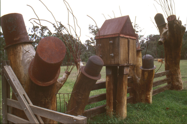
Sculpture: Tony Trembath (b.1946 Sale, Victoria), Tony Trembath, The Fences Act 1968 - Location: Edendale Farm (entrance) 30 Gastons Road, Eltham, 1989 - 1994
Eltham Council (now the Shire of Nillumbik) commissioned this work in 1989 to create an entrance / gateway to Edendale Community Farm. It was also aided by a grant from the Ministry of the Arts (now Arts Victoria). The former name of this work was "Gateway to Edendale Farm". Edendale Farm is a demonstration farm modelling sustainable environmental practices, providing support to the local residents of Nillumbik. Established in 1986, the land was purchased in 1970. It was previously an English gentleman's residence and was used for grazing. It consists of 5.6 hectares, with the Diamond Creek meandering through the property. The Victorian Fences Act 1968 governs liability of occupiers of adjoining lands to fence, and deals with disputes between neighbours regarding boundaries fences and costs. This work took into consideration ideas and suggestions from residents and committees, who required the use of recycled materials and that the work celebrate man's relationship with nature, animals and the earth, as well as relate to the fence-line on the far side of the carpark. Trembath also absorbed significant aspects of local history, making references to Eltham's agricultural past, the clearing of the land, the destruction of trees, the ruthless pruning of trees by suburban Councils and incorporated such Australian features as the post and rail fence. 'The Fences Act 1968' is significant for aesthetic, historic and social reasons at a regional level. It makes prominent the historical and social significance of Edendale and the rural aspects of Nillumbik. The use of existing tree stumps and salt pots in the work explores the iconography of the countryside such as the isolated farmhouse, pioneering farming practices, post and rail fencing and the regrowth of lopped trees. The title of the work, as well as the extensive community involvement in its creation, also makes reference to the Victorian Fences Act 1968, which makes neighbours jointly responsible for the cost of construction and maintenance of fences in the partitioning of land for settlement. 'The Fences Act 1968' has been classified as of regional significance by the National Trust of Australia. The work is an installation of wood and metal, approximately twenty five meters long. The design is very informal and rustic and runs the full width of the fence-line. It comprises groups of recycled tree trunks fitted with metal caps (chrome-nickel 'salt pots' that are shaped like tall bowler / top hats). Metal rods protrude from the trunks and some of these rods have metal birds. Two larger, sentinel-like stumps at the two outer ends have metal flame-like wings, which bend inward. To the left of the entrance, a simple architectural element indicates an isolated farmhouse. The rustic fence runs between the groups of tree trunks with native planting in clumps along it. The fence-line incorporates a functional engineered double gate and post and rail fencing. There may be many interpretations of the work and the intention is to stimulate interest and imagination rather than alienate. Interpretation is based on the personal experience that a visitor brings. The artist recommended that no explanation of the design logic be positioned with the work. N/Apublic art, sculpture, edendale, recycled, wood, metal, fences act 1968, gate, trembath, salt pot, tree stumps -
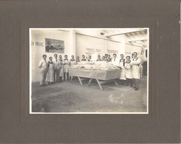 National Wool Museum
Photograph
Photo depicts a final year woolclassing class from the Gordon Institute in Geelong. They have prepared a display re: woolclassing for the visit of the Prince of Wales to Geelong in 1920. They are on the top floor of the Dennys Lascelles woolstore. The donor's father, Mr Cyril Cameron, can be seen in the photo at sixth from the right. Cyril Cameron (known as 'Cam') came from the family property 'Burnside' near Glenthompson in the Western District. He joined Strachan & Co. as an office boy in Aug. 1914 and then joined the 8th Battalion, 1st AIF in January 1915. He returned to Australia in early 1920 and started work at Strachan's again. He did the wool classing course (one year, evening?) at the Gordon in 1920-21. He became Head Wool Valuer at Strachan's in 1938 and retired in 1970. His office at Strachan's was on the top floor, directly overlooking what is now the entrance to the National Wool Museum (formerly Dennys Lascelles woolstore). He died in 1983. Interestingly, within the photo, can be seen a poster on the wall advertising the RSS or Diggers' Mill. The mill opened in 1922 but had been advertising for investors since the end of the war.Photograph, Gordon Technical College wool classing course, 1920. Wool classing display for the visit of the Prince of Wales at the Dennys Lascelles wool store.GEOFFREY S. WOOD, PHOTO, GEELONG Dennys Lascelles Show Floor 1920 / Visit of Prince of Waleswoolclassing royal visits, gordon technical college - woolclassing department, cameron, mr cyril, dennys lascelles wool store, woolclassing, royal visits -
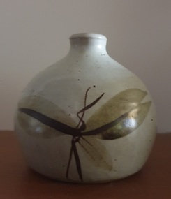 Ballarat Heritage Services
Ceramic, Small bottle by Ray Molony
Ray MOLONY Born Albury, New South Wales "Notes for Raymond Walter Molony: Raymond Walter Molony grew up in the Dandenongs, and Maffra where he went to school. He attenended Sale Technical School, before studying at R.M.I.T. from where he gained a diploma of pottery and technical teaching qualifications. He taught at Shepparton Technical College leaving there in 1977 to become a full time potter. Ray Molony established the Mud Factory Pottery in Shepparton in 1977 after purchasing, renovating and extending the old Kialla Methodist church, and building a two storey mud brick pottery. Two of Ray and Deirdre Molony's sons, Kevin and Russell, were employed during the 1980s and 1990s. Kevin Molony left due in the early 1990s due to the recession at that time, and Russell Molony followed soon after. Both competent throwers, with Russell making some creative slab work while Ray continuing to decorate the works. Ray Molony continued to produce studio ceramics at the kialla studion until selling the property in 2000, and semi retiring to Miepoll. In 2005 he moved to Pottsville New South Wales." studio potterySmall ceramic bottle with leaf designs in brown glaze made at the Mud Factory Pottery by Ray Molony.ceramics, studio pottery, ray molony, mud factory pottery -
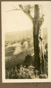 Mt Dandenong & District Historical Society Inc.
Photograph
The photograph is from the album of Ivy May Child. It shows a view across the holding of Walter Jeeves. Walter was the second son of Ellis Jeeves and grandson of Isaac Jeeves, the pioneer. Walter was given the house 'Kalorama' and 20 acres of lnd - most of it sloping. He established a commercial garden, initially growing vegetables but later flowers and shrubs. This land now forms part of Kalorama Park. The building in the photograph is the Kalorama Homestead with shrubs and trees planted in rows on the sloping site. Ivy May Child (1910 – 1989) was the daughter of Arthur Edward (Ted) Child (1878 – 1964) and Ethel May Madden (1888 – 1970). Ted Child was the son of Matthew Francis Child (1839 – 1933) and Martha Jeeves (1857 – 1926). He was the grandson of one of the early pioneers Francis Child. Ivy grew up on the family property on Childs Road and took many photographs. Most of these are glued into her photo album. The album covered the years from c1927 – 1932. Ivy married Henry William Burgess (1906 – 1968) in 1944. The photographs remain in their original state in the album with individual copies made. Black and white photograph with a large gum tree in the foreground, a sloping area of cleared, cultivated land and homestead in the centre and a forested area in the distance.An inscription below the photograph in the album reads: W. JEEVESwalter jeeves, jeeves, kalorama homestead, kalorama park -
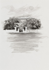 Bayside Gallery - Bayside City Council Art & Heritage Collection
Work on paper - ink and watercolour, Annette Meikle, Karinga, 1977
In 1977, artist Annette Meikle undertook a commission to illustrate a book recording stories of places and people in the Bayside area. It was published in 1978 as Sandringham Sketchbook, with text by Elizabeth Waters. The sketches were intended to record remaining examples of Bayside’s early architecture and environment, as well as reflect newer architectural changes. Meikle went on to donate 22 of these sketches to Bayside City Council in 2003. This inter-war house located at 60 Bluff Road, Black Rock, was built in 1926 for former Scotland Yard and Criminal Investigation Branch detective Horatio Reginald Clarence McWilliams. When McWilliams died it was found that he had taken extreme measures to protect his security. All the windows were nailed shut, a network of burglar alarms ran through the house and a complicated underground air raid shelter had been built in the garden. The security measures were at odds with the name of the house – Karinga or Karinya – an Aboriginal word meaning peaceful, happy home. Later residents of ‘Karinga’ included Senator Don Chipp and his family. The property has since been demolished and apartments have been built on the land.Annette Meikle, Karinga 1977, ink and watercolour, 32 x 23.5 cm. Bayside City Council Art and Heritage Collection. Donated by the artist, 2003annette meikle, sandringham sketchbook, elizabeth waters, black rock, karinga, karinya, horatio reginald clarence mcwilliams, senator don chipp, historic house, bluff road -
 Surrey Hills Historical Society Collection
Work on paper - Photograph, Nethercourt Private Hospital, Surrey Hills, c 1924, 1924
Notes from a previous collection coordinator indicate that Miss Lucy Musselwhite (Lillywhite) opened the hospital in 1914 and Matron Eliza Tank took it over in 1921 and named it Nethercourt Private Hospital. However recent research suggests that Miss Musselwhite (name confirmed) moved from Tooronga to Wilson Street some time between 1903 and 1909. She and her mother Elizabeth are listed in the 1909 electoral rolls in Wilson Street and Lucy's occupation is given as nurse. (It is of course possible that the property was a residence only at this time and later opened as a private hospital.) The name Nethercourt was used prior to Matron Eliza Tank taking over. Her daughter Irene was also a nurse at Nethercourt. Lucy Musselwhite was born in 1873 in Hampshire. She married Henry James Dore in later life and lived in Brenbeal Street, Balwyn. She died in 1955. In 1930 / 1935 Matron Tank transferred the hospital to 219-223 Union Road. Later it was known as Norwich Hall / St Jude's. Mosgiel Hospital in Mont Albert Road also opened in 1924. After this time home births became less common. Nethercourt Hospital closed in the 1960s.Small hospitals such as this one were primarily used for midwifery, preceding the development of larger centralised general hospitals. Black and white photo of Nethercourt Private Hospital at 11 Wilson Street in c 1924 taken from the street in winter. The building is Victorian in style; block-fronted with lacework detail to the verandah and has 2 chimneys. It is set behind a wooden picket fence behind which is a well-manicured hedge which appears to have been grown across the front entrance gate.nethercourt private hospital, midwifery, hospitals, matron eliza tank, miss lucy musselwhite, miss irene tank, mrs irene anderson -
 Vision Australia
Administrative record - Text, Royal Blind Society of NSW Council meeting minutes: 20/1/1958 - 3/9/1963, 1958-1963
These minutes contain information on attendees, meeting chairs, apologies, correspondence, subscriptions, donations, legacies and general business. Reports are also included from Auxiliaries, Auditors, Library and Home teacher, Directors, The Black and White committee, Victor Maxwell House, Helen Keller Hostel, The Victor Maxwell Kindergarten, The Sandy Robertson Kindergarten, Alexis Albert House, Silver Lighthouse committee, 'Heathfield' and other Woollahra properties. 20/1/1958 it was noted that considerable developments were taking place with respect to the recording of books on discs to tape and the Society will adopt system of recording set out by R.N.I.B. 24/2/1958 an order for 100 small silver plated lighthouses had been decided on to be presented to outstanding benefactors of the Society. 15/8/1959 'Lighthouse', home for aged Blind women was opened. 5/9/1958 The President welcomed the first 6 residents to Alexis Albert House, home for aged Blind men. 6/9/1958 The Newcastle Blind Centre was opened. 23/9/1963 it was unanimously resolved that 5 Lots comprising of the estate left by the late Mrs F. I. Skovronksi were to be sold. 1 volume with sheets pasted on to pagesroyal blind society of new south wales, alexis albert hostel, victor maxwell kindergarten, sandy robertson kindergarten, helen keller hostel -
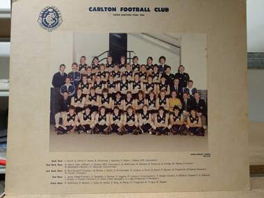 Carlton Football Club
Colour photograph, Under 19 team 1984, 1984
From Roger Skien Collection. Back Row: J. Smith, D. Zerna, P. James, B. Whitemore, J. Rainone, P. Albon, J. Baker (P.E. Instructor) 2nd Back Row: G. Warry (Development Officer), J. Stevens (P.E. Instructor), A. McKinnon, G. Hatvani, P. Starbuck, D. Forbes, M. Hanna, P. Cronin, D. Bolzonello (Doctor), K. Newman (Committee). 3rd Back Row: R. Shuttleworth (Trainer), W. Burke, J. Hullin, D. Krittemeyer, R. Lowery, A. Price, G. Evans, P. Muscat, N. Fitzpatrick (Property Steward), H Turner (Trainer) 2nd Row: L. Jones (Head Trainer), D. Nardella, J. Dunlop, P. Higgins, P. Lumicisi (Vice Captain), T. Keogh (Coach), S. Baldwin (Captain), S. Glasscott, I. Aitken, J. Vincent (Runner), R. Skien (Team Manager), A. Lugg (Treasurer, Time keeper). Front Row: P. Wilkinson, P Merson, J. Cook, M. Hailes, S, Gray, S. Potter, D. Fitzgerald, M. Turgut, W. Pepper.Colour team photograph mounted on cardboard -
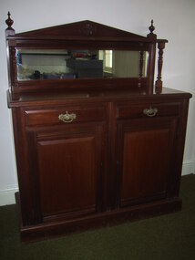 Parks Victoria - Cape Nelson Lightstation
Furniture - Sideboard
The cedar sideboard has two cupboard doors below two corresponding drawers. The style is in keeping with the completion date of the lightstation in 1884, when furniture in the late nineteenth century had squarer, more defined lines and angles, and ornamental features. This sideboard is a modest version of this trend combining a pediment‐shaped back board with turned side columns and finials, rectangular mirror, decorative drawer pulls and door handle, as well as cupboards and drawers with bevelled, raised panels. The initials ‘PWD’along with a crown motif and letters are inscribed on the side indicating that the furnishing was the property of the government and made in its workshops. The Public Works Department, which operated in Victoria from 1855 to 1987, was responsible for the design of Victoria’s major public buildings and provision of furnishings to its offices as well as residences where the need was required.301 The keepers’ quarters at Cape Otway Lightstation were supplied with two of the same sideboards, which remain there today; on is intact (COLS 0001), the other missing the backboard (COLS 0015). Two similar but plainer examples, which are probably earlier in date, also remain at Cape Schanck (CSLS 0007.3; CSLS 0009.3). The Cape Nelson sideboard has first level contributory significance as a fine example of the good quality domestic furnishings made by the Victorian Government and provided to lighthouse keepers and their families in the late nineteenth century. It is also significant for its provenance to the lightstationThe cedar sideboard has two cupboard doors below two corresponding drawers with pediments‐shaped back board with turned side columns and finials, a rectangular mirror, decorative drawer pulls and door handle, as well as cupboards and drawers with bevelled, raised panels. -
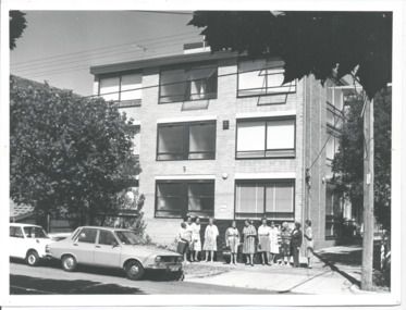 Melbourne Legacy
Photograph, Widows' Flats, 1976
A photo of a group of widows outside a block of units in Windsor, that Legacy purchased to provide accomodation for widows. Names unknown but possibly the first tenants to move into the units. From the date stamp is it February 1976. The September 1975 edition of the Legacy Newsletter to Widows, mentions the 20 flats purchased by Legacy at 9 The Avenue, Windsor, and that they are being renovated for widows to live in. Two options were presented, an 'ingoing' amount of $5,000 then a week maintenance charge of $7 a week; or on a rental basis of approximately $20 a week. (a copy of the Title deed shows the flats were purchased on 7 February 1975). Purchase price was $205,000 with the Department of Social Security requiring the addition of lifts to the building (approximate cost $100,000). From President's highlights report in 1981 we know that external blinds were added to the property. The Windsor units were named "Miriam and Frederick James Ramsay Lodge" after a generous donation in 1987. It was decided the Windsor units, and the ones in Hawthorn, would be sold in 2003 and announced by President Tony Parkes. The decision was published in Leader newspapers and Jellis Craig approached Legacy about the sale, see items at 01089.A record of widows being looked after by Legacy by being provided with affordable housing.Black and white photo of Legacy's flats for widows in The Avenue, Windsor.Handwritten 'Legacy Hostel / 9 The Avenue / Windsor' in blue pen. 'Box 11' in black pen. Stamped 'Melbourne Legacy 3 Feb 1976' in purple ink.widows, properties -
 Melbourne Legacy
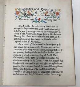
Document, Origin and Record of Blamey House December 1939 - January 1947, 1987
Copies of correspondence with Mr K Crouch asking for the history of Blamey House. Plus a photocopy of the history pages from the Blamey House roll that is kept in glass display cabinets at Legacy House. Blamey House was one of the residences used by Legacy as a home for Junior Legatees. The first few pages of the book (item 02298) explains the history and significance of the name Blamey House - which was photocopied and sent to Mr Crouch. Blamey House was originally the name of a hostel set up in World War 2 for servicemen that needed short term accommodation and food. It was originally situated in Melbourne CBD on the corner of King and Collins Streets in the Robbs Building (since demolished). When the hostel was no longer required after the war, the trustees of Blamey House donated money - almost 20,000 pounds, to Legacy for a children and toddlers' home which was established in Balcombe Road Beaumaris. The condition of donation was that the name Blamey House be used and when the Balcombe Road property was sold in 1956 the name was transferred to Holmbush, another Legacy residence. When it was sold in 1977 the name transferred to Harelands until Legacy sold it in 1980.A record of the history known about the donation made to Legacy to establish Blamey House in 1947.Black and white A4 photocopy x 12 pages on history of Blamey House, part of it copied from the Blamey House roll and some of correspondence between K Crouch and Legacy.blamey house, blamey, residences, hostel -
 Wooragee Landcare Group
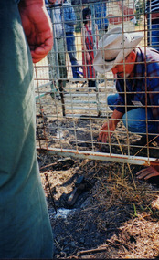
Photograph, 3rd April 2004
Wooragee Landcare, since its establishment in 1998, has organised a series of events and activities in order to promote weed and pest control, provide assistance and knowledge to landholders and ensure sustainability and protection of natural vegetation. This photograph was taken on the 3rd April 2004 as part of an event called "Spotlight on Fox", organised by the Wooragee Landcare Group. It was addressed to all landholders in the area and involved practical demonstration of techniques suitable for integrated fox control. Camille Velesky, who is illustrated in the photograph, was the presenter; he is a specialist in fox behaviour and has worked for 27 years on pest control. Under the Catchment and Land Protection Act 1994 (CaLP Act) foxes are declared as established pest animals and landowners have the responsibility to take reasonable steps to protect their land from established pest animals. The most commonly used management techniques are baiting, shooting, guard animals, fencing, trapping, canid pest ejectors, above-ground harbour removal, property hygiene and fumigation. Trapping, due to the significant suffering and distress that causes to foxes, has significant animal welfare implications and should be avoided if there is another suitable alternative. The photograph is an example of the type of events and activities organised by Wooragee Landcare to educate and inform local residents and landholders on the most suitable techniques for integrated fox control. Wooragee Landcare, abiding by its mission statement, promotes best land management strategies and ensures sustainability through collaboration with local community and council agencies.Portrait coloured photograph printed on gloss paper. Reverse: WAN NA 0ANA2N0 NNN+ 1 8743/ [PRINTED] (No.10)/256/spotlight on fox, wooragee landcare group, integrated fox control, camille velesky, fox behaviour, pest control, catchment and land protection act 1994, calp act, established pest animals, baiting, guard animals, fencing, trapping, trap setting demonstration, weed and pest control, sustainability, natural vegetation, fox dens, fumigation, animal welfare -
 Melbourne Tram Museum
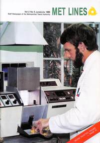
Magazine, Metropolitan Transit Authority (MTA), "Met Lines Vol. 2, No. 5", July 1986
Staff newspaper or magazine published by the Metropolitan Transport Authority, The Met, June/July 1986 Features an article on the Chemists at the Preston Workshops with a photo of Graham Cox on the front cover and Garry Smith on pages 6 & 7 Has message from Kevin Shea, Managing Director along with items on: The Clock Shop - Mike Barker, Charlie Roonui, Peter Cohen and Ray Brun Lost Property - Peter Lopriorre, Tony Germane, Stan Mintzis, Jerry Styulianou. David Bartolo Driving buses is not easy Noel Donchi, with a photo of Munitions bus 301, AVM extended to trams - Tom Roper, Z3 223 Appointment of Russ Ingersoll as chairman of the MTA Civil Branch trackwork - Peter Kargas, Steve Chambers, Michele Giannetta, P Lombardi, S Luci, More Safety Zones for tram network with trams 967 and tram 871 New Look for Preston Workshops Shelters provide passenger comfort - with photos of four shelters Painted trams ride the track again - Tom Roper and Race Matthews - launch of new series Extra comfort for tram travellers - launch of B1 2001 Demonstrates a MTA staff magazine.Magazine - "Met Lines Vol. 2, No. 5" - 36 A4 pages, colour, centre stapled.preston workshops, laboratory, bundy clock, lost property, bus 301, buses, avm, transporting art, tram 223, track maintenance, tram 967, tram 871, safety zones, shelters, tram 2001 -
 Ballarat Heritage Services
Photograph - Digital photograph, Nose in Admiralty Arch, London, 19/09/2016
Admiralty Arch is a landmark building in London which incorporates an archway providing road and pedestrian access between The Mall, which extends to the southwest, and Trafalgar Square to the northeast. Admiralty Arch, commissioned by King Edward VII in memory of his mother, Queen Victoria and designed by Aston Webb is now a Grade I listed building. In the past, it served as residence of the First Sea Lord and was used by the Admiralty. Until 2011, the building housed government offices, but in 2012 the government sold a 125-year lease over the building to a property developer (Prime Investors Capital, run by Rafael Serrano) for redevelopment into a luxury hotel, restaurant and apartments. (Wikipedia) On the inside wall of the northernmost arch is a small protrusion the size and shape of a human nose. It was placed there by artist Rick Buckley in 1997 as part of a campaign against the "Big Brother" society. The nose is at a height of about seven feet, and sits at waist height for anyone riding through the arch on a horse. Prior to Buckley being unmasked in 2011 by the London Evening Standard, an urban myth grew that the nose is there in honour of the Duke of Wellington, who was known for having a particularly large nose.(wikipedia)admiralty arch, london, nose -
 Bendigo Historical Society Inc.
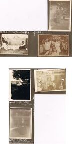
Photograph - HILDA HILL COLLECTION: BLACK AND WHITE PHOTOS, 1917-1924
Series of Black & White Photos Total 6 Hill Family & Friends During the First World War and after. Rita, wearing a dark dress with white collar and holding a dark coloured hat, background is large brick structure with windows to right and small section of veranda, pal tree, Railway Reserve Kyneton 1918. Man and two women wearing white dresses and dark hats, man wears dark suit white shirt and dark tie with his back against a large wheel, white sheet on ground between them and indistinguishable articles on sheet, Hibernian Picnic Axedale November 13th 1918. Group of young girls and boys all dressed in light coloured clothing gathering Botanical gardens January 1917, Miss N. Linnane reclining on cane lounge chair on verandah, weatherboard wall of house, verandah post, rock garden edging in foreground, May 1918. Monte Video Property Queensland Jeff, dressed in dark trousers and white shirt, holding a skinned rabbit, water tank in background, wire fence, July 1924. Father & Mother, Father wears a grey suit with white shirt and dark tie, Mother seated is wearing a dark dress with striped collar and white blouse, 'The Ranche' Mollison Street Eppalock.Hilda Hill Personal Collectionaustralia, history, post war life -
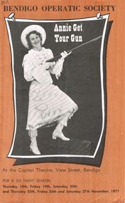 Bendigo Historical Society Inc.
Programme - BENDIGO OPERATIC SOCIETY ''ANNIE GET YOUR GUN''
Bendigo Operatic Society ''Annie Get Your Gun'' At the Capital Theatre View Street Bendigo for a Six Night Season Commencing Thursday 18th November,1971. Producer: Max Collis. Assistant Producer, Bellet and Wardrobe Mistress: Madge Welch. Society Pianist: Ruth Gorman. Musical Director: Gwen Grose. Cast: Kerry Lorenz as a Small Girl - Ferd Lorenz as Charlie Davenport - Shane Brennan as Mac (Property Manager) - Douglas Sayle as Foster Wilson - Ann Ball as Dolly Tate - Annette Beckwith as Winnie Tate - Terry Carr as Tommy Keeler - Len Carr as Frank Butler - Heather Lindhe as Annie Oakley - Mark Edebone, Peter Miller as Little Jake - Debbie Moyle, Rosemarie Favaloro as Nellie - Jennifer Carr, Cathy Johnson as Jessie - Judith Hall, Suzanne Hartley as Minnie - Brian Thomas as Col.Wm F. Cody - Valerie Griffith as Mrs. Little Horse - Wilma Baldwin as Mrs. Black Tooth - Kerry Hogan as Trainman - Bridgette Agnew as Waitress - John Tonkin as Conductor - Bernard Keogh as Major Gordon Lillie (Pawnee Bill) - Fred trewarn as Chief Sitting Bull - Ann Rundall as Wild Horse Ceremonial Dancer - Jan Lovett as Sylvia Potter Porter - Jill James as Mrs. Adamsprogram, theatre, bendigo operatic society -
 Kew Historical Society Inc
Plan, Melbourne & Metropolitan Board of Works : Borough of Kew : Detail Plan No.1301, 1910
The Melbourne and Metropolitan Board of Works (MMBW) plans were produced from the 1890s to the 1950s. They were crucial to the design and development of Melbourne's sewerage and drainage system. The plans, at a scale of 40 feet to 1 inch (1:480), provide a detailed historical record of Melbourne streetscapes and environmental features. Each plan covers one or two street blocks (roughly six streets), showing details of buildings, including garden layouts and ownership boundaries, and features such as laneways, drains, bridges, parks, municipal boundaries and other prominent landmarks as they existed at the time each plan was produced. (Source: State Library of Victoria)This plan forms part of a large group of MMBW plans and maps that was donated to the Society by the Mr Poulter, City Engineer of the City of Kew in 1989. Within this collection, thirty-five hand-coloured plans, backed with linen, are of statewide significance as they include annotations that provide details of construction materials used in buildings in the first decade of the 20th century as well as additional information about land ownership and usage. The copies in the Public Record Office Victoria and the State Library of Victoria are monochrome versions which do not denote building materials so that the maps in this collection are invaluable and unique tools for researchers and heritage consultants. A number of the plans are not held in the collection of the State Library of Victoria so they have the additional attribute of rarity.Original survey plan, issued by the MMBW to a contractor with responsibility for constructing sewers in the area identified on the plan within the Borough of Kew. The plan was at some stage hand-coloured, possibly by the contractor, but more likely by officers working in the Engineering Department of the Borough and later Town, then City of Kew. The hand-coloured sections of buildings on the plan were used to denote masonry or brick constructions (pink), weatherboard constructions (yellow), and public buildings (grey). Throughout its history, the land in what is known today as Studley Ward of the City of Boroondara has been subject to continuing subdivision. This is evident in Plan 1301, where later hands have modified the original map to include streets created subsequent to the printing of the plan in 1904. Other annotations such as the ‘Reserved for Road Purposes’ beside the Yarra never eventuated. The plan continued to be modified to at least 1953, when a later hand noted that a particular site was ‘Property site P. McIntyre house’ in Swinton Avenue. Two significant houses in the area are outlined on the plan: ‘Swinton’ on the corner of the streets then named Effey and Maud Streets (now Swinton Avenue) and ‘Fairhaven’ [unnamed] in Stevenson Street. The gardens of the two David Syme owned mansions of ‘Blythswood’ and ‘Rockingham’, stretching down to the River Yarra, are also represented.melbourne and metropolitan board of works, detail plans, mmbw 1301, cartography -
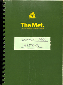 Melbourne Tram Museum
Document - Report, The Met, "Wattle Park", 1989
Report - approx. 90 A4 photocopied sheets, within a green cover preprinted for "The Met", titled "Wattle Park" containing many documents concerned with the history of Wattle Park and its status legally within a black comb binder. Comprises: 1 - Map 2 - two page letter from Tom Roper Minister for Planning and Environment to Jim Kennan Minister for Transport dated 22/11/1988. 3 - two page history 4 - two page extract from the Nov - Dec 1966 issue of MMTB News 5 - 23 pages - handwritten "Notes of Address on early history of Wattle Park given by A. J. Holt to the Box Hill Historical Society Nov. 1986. 6 - 10 page extract of the Act authorising the HTT to acquire the land and extracts from Hansard 7 - 4 page letter by the Office of the Solicitor to The Met Property department 1/12/1986 about the use of the land and charging fees for its use. 8 - 15 page legal advice re the use of the land and its permitted uses. 9 - 13 page follow up advice by P. N. Wikrama dated 20/6/1989 10 - 6 page photocopy of the certificates of title. Each section separated by a green sheet.trams, tramways, wattle park, legal agreements, htt, mmtb, the met, minister for transport -
 Eltham District Historical Society Inc
Document - Folder, Mann, John and Violet and family
John Mann arrived from Forfar, Scotland, on the clipper packet "Ellen Stuart" in 1857 and rented a farm "Overton" at Janefield. Soon after he met Melbourne-born Violet McKimmie, whose parents had a property near Darebin Creek. They married on 25 September 1862, John 26 and Violet 19. In 1874 John selected a block on Arthurs Creek and built a slab and bark hut (still standing in 1984) and called their farm "Carseburn" after John's parish in Scotland. They had seven children: John, Jane, Christine, David, Walter, James and Violet. John was drowned in the Yarra in May 1875 and Violet struggled to meet the lease commitment. She wrote to her brother-in-law David Mann in New Zealand who came to her aid, and on 10 September 1876, they married at the Victorian Free church, Smith Street, Collingwood. They improved the farm and built a three-room house. in July 1883 they bought neighbouring land from Ann Welsh. With David, Violet had four more children: Robert, William and twins Thomas and Henry. In 1883, David died and was buried in the same grave as his brother in Preston Cemetery. The twins also died, Thomas just before and Henry just after their father. the children assisted with the farm and orchard, the business including crops, a dairy herd, Carseburne sheep, and breeding horses. Violet died at Yan Yean in 1925, aged 83. A grandson of John Mann, James Mann, lived in Henry Street, Greensborough and had given a talk at the Whittlesea Historical Society in 1983 on his family. Descendant Lindsay Mann was part of a creative writing group that published a book including a short story "The Mountain Tramway" is loosely based on his childhood and stories he was told then but was planning to write his family story. Contents Newspaper article: "Tragedy couldn't stop this pioneer", Diamond Valley News, 31 January 1984, story of Mann family. Newspaper article: "Tracing the history of ordinary. people," Diamond Valley News, 29 July 1986, story of Mann family, researched by descendant Lindsay Mann who grew up at the Mann property She-Oak at Yan Yean and has numerous family records. Newspaper article: "A realist who captures light," Diamond Valley News, 29 July 1986, David Moore, a realist painter had been working from a studio at Montsalvat and his exhibition of work from that period was to open 1 August 1986 at the Victorian Artists Society Galleries.Newspaper clippings, A4 photocopies, etcjohn manan, violet mann nee mckimmie, clipper packet "ellen stuart", forfar scotland, darebin creek victoria, arthurs creek victoria, "overton" at janefield, "carseburn" at arthurs creek, jane mann, christine mann, david mann, walter mann, james mann, violet mann, victorian free church smith street collingwood, ann welsh, robert mann, william mann, thomas mann, henry mann, preston cemetery, carseburne sheep, yan yean cemetery, lindsay mann, david moore, montsalvat -
 Eltham District Historical Society Inc
Photograph, Liz Pidgeon, Public Records Office Victoria (PROV) visit to Eltham Justice Precinct, 20 Apr 2018
The original Shire of Eltham was founded in 1871. Prior to its founding, the district was managed by the Eltham District Road Board, which was established in 1856. The initial rate assessment commenced in 1857 for the year ending October 14, 1858. The honour of being recorded with the first assessment went to a farm of 110 cultivated acres at Lower Plenty, owned by John Porter and occupied by Albert Baines. It was assessed at 6d/acre providing for a rate income of £2 15s. In July 2017, officers at Nillumbik Shire Council discovered some early Eltham Road District Assessment books and donated them to the Eltham District Historical Society. The seven volumes were the district’s first six years of rate assessments. This was a unique and significant record of early settlers in the pre-Shire of Eltham. They immediately became one of the oldest and most valuable items in our collection. An article on page 5 in the Eltham and Whittlesea Shires Advertiser, Friday, 21 November, 1941 titled: ‘District’s Early History‘ states: “The first rate book which is still in existence at the Shire Office is for the year ending October 14, 1858 and is probably the best record possible to indicate the development of the district. At the time properties were rated as follows: Cultivated land. 6d. per acre; pasture land, 1d. per acre: estimated annual value of buildings, etc., 6d in the (pound). The total amount of rate recorded for the year was £153/14/8. Properties were described as being situated at Lower Plenty, Yarra Yarra, Eltham, Lower Eltham, Kangaroo Ground, Yarra Flats, Diamond Creek and the Yarra.” Given the precious nature of this collection, priority was given to digitise the rate books and place them in suitable archival storage to minimise further handling. Subsequent discussion amongst our Collections team arrived at the conclusion that the most appropriate home for this valuable record was the Public Record Office Victoria (PROV), the archive of the State Government of Victoria and who are charged with archiving and caring for all Government related records. An approach was made to PROV who confirmed these records would complete their collection of rate assessment books for Eltham. At a small ceremony held Friday, April 20 at the Local History Centre, Eltham, members of the Society and our Collections team, along with Ms. Vicki Ward, MP for Eltham, presented the seven volumes for 1858-1863 along with the complete set of digital files to Mr. David Taylor, Community Archives Manager and Mr. Charlie Farrugia, Senior Collection Advisor, Public Record Office Victoria.Born Digitalassessment ledger, donation, eltham courthouse, eltham road district, local history centre, public records office victoria (prov), rate books, eltham district road board -
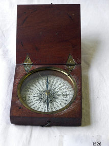 Flagstaff Hill Maritime Museum and Village
Instrument - Compass, c. 1839
This magnetic compass is a good size to fit easily into a person's pocket or personal luggage and is protected from knocks by its wooden case. It could have been used for reference when travelling on land or sea. There is no visible manufacturer's mark, which may mean that it was not of high monetary value. Leith is a district of Edinburgh in the country of Scotland, the U.K. It was once the Port of Edinburgh and many migrant ships departed from here bound for the Australian colony. It had a busy shipbuilding industry, with wet and dry docks. It appears from the inscription on the case "Chas Gray, LEITH, 1839" that this pocket compass once belonged to Charles M. Gray (Chas is a common abbreviation for the name Charles). The inscription coincides with the name, place and date that the Western Victorian pioneer Charles M. Gray left Scotland and arrived in Australia. Charles Gray was born in Anstruther, Scotland, in 1818. His family was connected with the Royal Marines, which may have created his nautical instruments such as this pocket compass. Charles Gray arrived in Hobson's Bay on 15 June 1839 on the ship “Midlothian”. That same ship had departed from Leith, Scotland on February 15th 1839. Did Charles Gray acquire the pocket compass in Leith, perhaps as a gift or a souvenir of his motherland? Charles Gray was an early squatter and went on to become a very successful settler as a sheep pastoralist in the Western District of what is now Victoria (originally the colony of New South Wales). He and his wife had a large property called “Nareeb Nareeb”, Green Hill Creek District (now Glenthompson), Victoria, from 1840-1886. He was also a local Councillor and Justice of the Peace, and had an interest in the local indigenous people; he named his property after their tribe. Charles returned to England in 1890 and died there in 1905. Charles Gray had written an account in 1890 of his life at Nareeb Nareeb, called Western Victoria in the Forties: "REMINISCENCES OF A PIONEER The Western District in the 1840's By Charles Gray" , a valuable historical reference to colonial Victoria. His book was published by the Hamilton Spectator in 1932. Charles Gray's photograph is one of 713 historical photographs of early Victorian settlers, created as a montage by Thomas Foster Chuck in 1872. The State Library of Victoria holds the framed montage titled “The Explorers and Early Colonists of Victoria”. To qualify for inclusion on this montage the Settlers must have arrived in Victoria before 1843. Charles Gray's photograph is number 349! The pocket compass is associated with Charles Gray, one of the early squatters and settlers in Western Victoria, possibly given to him as a parting gift on his emigration to Van Diemans land in 1839. The item is very significant as it's connection with one of Victoria's early pioneers is well provenanced by the inscriptions on the wooden case. Pocket compass, brass, set into a square wooden case with hinged lid and small hook catch. Compass is marked with 360 degrees and compass points and has two pointers; one to show magnetic north and one to set the direction of travel. Hinges are triangular and inset into the wood. The lid has an attached brass plaque with the inscription "Chas Gray, Leith, 1839" (It likely belonged to Charles Gray, Leith, UK, who migrated to Port Philip Australia in 1839 and became a successful pastoralist.) “Chas Gray / LEITH / 1839” engraved on brass plaque on lid.flagstaff hill, warrnambool, shipwrecked coast, flagstaff hill maritime museum, maritime museum, shipwreck coast, flagstaff hill maritime village, great ocean road, magnetic compass, pocket compass, charles m. gray, chas gray, migrrant from leith 1839, charles gray anstruther, scottland, ship midlothian 1839, squatter western victoria, settler western victoria, hobson's bay port phillip australia, charles gray nareeb nareeb - green hill creek district, western victoria in the forties: reminiscences of a pioneer by charles m. gray 1890, leith edinburgh u.k., western victoria in the forties: reminiscences of a pioneer - montage by thomas foster chuck 1872, charles gray, reminiscences of a pioneer, the western district in the 1840's, compass, scientific instrument, nautical instrument, direction, directional compass, navigation